
ATL: BERTHA - Post-Tropical - Discussion
Moderator: S2k Moderators
-
tropicwatch

- Category 5

- Posts: 3426
- Age: 62
- Joined: Sat Jun 02, 2007 10:01 am
- Location: The Villages, Florida
- Contact:
The dry air and wind shear have diminished considerably.
0 likes
Tropicwatch
Agnes 72', Eloise 75, Elena 85', Kate 85', Charley 86', Florence 88', Beryl 94', Dean 95', Erin 95', Opal 95', Earl 98', Georges 98', Ivan 2004', Arlene 2005', Dennis 2005', Ida 2009' Debby 2012' Irma 2017' Michael 2018'
Agnes 72', Eloise 75, Elena 85', Kate 85', Charley 86', Florence 88', Beryl 94', Dean 95', Erin 95', Opal 95', Earl 98', Georges 98', Ivan 2004', Arlene 2005', Dennis 2005', Ida 2009' Debby 2012' Irma 2017' Michael 2018'
-
TheAustinMan

- Category 5
- Posts: 1060
- Joined: Mon Jul 08, 2013 4:26 pm
- Location: Central TX / United States
Mid level shear is still persisting over Bertha but overall the upper/lower level averaged shear has dropped like a rock in the area surrounding Bertha.
0 likes
Treat my opinions with a grain of salt. For official information see your local weather service.
“It's tough to make predictions, especially about the future.”
“It's tough to make predictions, especially about the future.”

Re:
TheAustinMan wrote:Mid level shear is still persisting over Bertha but overall the upper/lower level averaged shear has dropped like a rock in the area surrounding Bertha.
So more favorable conditions immediately ahead of it?
0 likes
The above post is not official and should not be used as such. It is the opinion of the poster and may or may not be backed by sound meteorological data. It is not endorsed by any professional institution or storm2k.org. For official information, please refer to the NHC and NWS products.
-
ozonepete
- Professional-Met

- Posts: 4743
- Joined: Mon Sep 07, 2009 3:23 pm
- Location: From Ozone Park, NYC / Now in Brooklyn, NY
Re: Re:
SeGaBob wrote:TheProfessor wrote:So if Bertha has trouble strengthening when it gets north of Carribean would it still recurve?
I'd like to know the answer to this as well.
Quite likely regardless of its strength. That longwave trough that is moving into the eastern U.S. will be strong enough to pick up even a weak system.
0 likes
-
ozonepete
- Professional-Met
- Posts: 4743
- Joined: Mon Sep 07, 2009 3:23 pm
- Location: From Ozone Park, NYC / Now in Brooklyn, NY
Re: ATL: BERTHA - Tropical Storm - Discussion
0 likes
-
ozonepete
- Professional-Met
- Posts: 4743
- Joined: Mon Sep 07, 2009 3:23 pm
- Location: From Ozone Park, NYC / Now in Brooklyn, NY
Re:
Gustywind wrote:Looks like Guadeloupe should face strongs TS winds during next couple of hours as Bertha is moving close to Dominica now. Whereas we're always under an yellow alert and no more for now but i follow closely the situation....
Hi gusty! Yeah the strongest for you is coming now. Let us know what's going on there but keep a watchful eye since it sure looks like Bertha is strengthening right now. A lot of heavy rain for you in the next few hours as convection is really increasing. And winds could really pick up in those biggest thunderstorms.
0 likes
-
Gustywind

- Category 5
- Posts: 12334
- Joined: Mon Sep 03, 2007 7:29 am
- Location: Baie-Mahault, GUADELOUPE
Re: Re:
ozonepete wrote:Gustywind wrote:Looks like Guadeloupe should face strongs TS winds during next couple of hours as Bertha is moving close to Dominica now. Whereas we're always under an yellow alert and no more for now but i follow closely the situation....
Hi gusty! Yeah the strongest for you is coming now. Let us know what's going on there but keep a watchful eye since it sure looks like Bertha is strengthening right now. A lot of heavy rain for you in the next few hours as convection is really increasing. And winds could really pick up in those biggest thunderstorms.
Hi my friend! Thanks for the reply. You're right
Regards
Gustywind
0 likes
-
Gustywind
- Category 5
- Posts: 12334
- Joined: Mon Sep 03, 2007 7:29 am
- Location: Baie-Mahault, GUADELOUPE
First report of Bertha arrival in Dominica...
 http://stormcarib.com/reports/current/dominica.shtml
- CONDITIONS DETERIORATING FAST...
•From: Alex Staunton <dtkcomp2002 at yahoo.com>
•Date: Fri, 1 Aug 2014 14:19:35 -0700
Good Afternoon/ evening to All!
Re:Bertha- - Conditions are now deteriorating rapidly on the North East Coast-
stronger gusts have been building from mid morning - some minor to moderate
squalls ocurred earlier...& they were mostly at or near gale force about 26-30
knots -& the ocean has been building steadily since and is now churning wildly
here on the North East coast of the island near Londonderry.
Bertha is looking better on radar-& it will take a while to transition into
surface satellite imagery, which is happening slowly- but unlike some storms
that have impressive satellite imagery and yet no 'bite' - Bertha is Definitely
a storm that's Big on surface action-as evident on radar- She definitely knows
how to 'dance.'
Tropical storm force winds have begun in earnest in my local area from about
3:40pm (Eastern Caribbean local time). Looking at the Martinique radar- it
seems like the North of Martinique is still getting punished currently. Here in
Dominica our Southern area is about to feel the brunt- I hope the reports of
last minute scrambles in the Capital today would have paid off over night And
into tomorrow... No doubt there will always be those who are caught
unprepared...Berta looks like it's intensifying right on the heels and
eventually right over Dominica (It's center according to Radar fixes being in
the Dominica/ Martinique Channel)... It will be a long night- keep us in
Prayer! Latest wind gusts at the nearest airport- Melville Hall outs too winds
at 37 knots...Cudos to our utility crews and to the 'French' guys at SxM
Cyclone who are doing a great job like so many if these wonderful weather
sites/ blogs.
Also, Long may the power live - a Great job by our local power company- Domlec
so far! Sadly Like I said in an earlier post- this storm has already been
deadly- earlier on-from its impacts all the way on the African coast- it does
bear watching for sure...Re: those ahead in its track... Let's All take good
care this season & God Bless!
With God all things are Possible! -
0 likes
-
ozonepete
- Professional-Met
- Posts: 4743
- Joined: Mon Sep 07, 2009 3:23 pm
- Location: From Ozone Park, NYC / Now in Brooklyn, NY
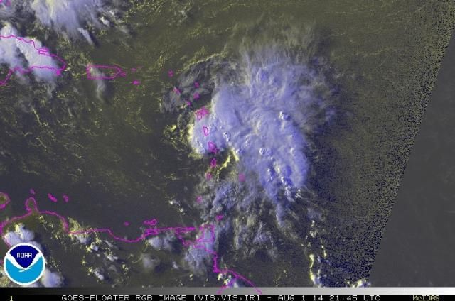
Re: ATL: BERTHA - Tropical Storm - Discussion
Look at how rapidly the convection has rebuilt over the center of this storm and over the eastern portion, and this happened at DMIN.
1:15 PM EDT
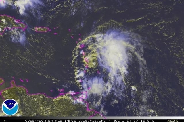
4 and 1/2 hours later at 5:45PM EDT:
1:15 PM EDT

4 and 1/2 hours later at 5:45PM EDT:

Last edited by ozonepete on Fri Aug 01, 2014 5:46 pm, edited 1 time in total.
0 likes
-
Gustywind
- Category 5
- Posts: 12334
- Joined: Mon Sep 03, 2007 7:29 am
- Location: Baie-Mahault, GUADELOUPE
Here is the latest from Dominica weather station as Bertha is the suprised guest...
http://weather.noaa.gov/weather/current/TDCF.html
Current Weather Conditions:
Canefield Airport, Dominica
Conditions at Aug 01, 2014 - 06:00 PM EDT Aug 01, 2014 - 2014.08.01 2200 UTC
Wind from the S (180 degrees) at 8 MPH (7 KT) gusting to 20 MPH (17 KT)
Visibility 1 mile(s)
Sky conditions mostly cloudy
Weather Rain showers
Cumulonimbus clouds observed
Temperature 78 F (26 C)
Dew Point 71 F (22 C)
Relative Humidity 78%
Pressure (altimeter) 29.74 in. Hg (1007 hPa)
ob TDCF 012200Z 18007G17KT 2000 SHRA FEW008 BKN010CB 26/22 Q1007
Latest 6 PM (22) Aug 01 78 (26) 71 (22) 29.74 (1007) S 8 rain showers
5 PM (21) Aug 01 78 (26) 71 (22) 29.77 (1008) WSW 6 light rain showers
4 PM (20) Aug 01 78 (26) 73 (23) 29.80 (1009) NNW 6 light rain showers
3 PM (19) Aug 01 80 (27) 73 (23) 29.85 (1011) NNE 8 light rain showers
2 PM (18) Aug 01 80 (27) 73 (23) 29.88 (1012) NW 1 light rain showers
1 PM (17) Aug 01 84 (29) 68 (20) 29.88 (1012) N 6
Noon (16) Aug 01 82 (28) 64 (18) 29.91 (1013) SSE 5
0 likes
-
HurricaneMaster_PR

- Category 2

- Posts: 795
- Joined: Tue Jul 22, 2003 6:23 pm
- Location: San Juan, Puerto Rico
Re: ATL: BERTHA - Tropical Storm - Discussion
ozonepete wrote:Look at how rapidly the convection has rebuilt over the center of this storm and over the eastern portion, and this happened at DMIN.
Interesting. I wonder how it will behave overnight during Dmax. Conditions could be getting a little more favorable compared to yesterday.
0 likes
-
northjaxpro

- S2K Supporter

- Posts: 8900
- Joined: Mon Sep 27, 2010 11:21 am
- Location: Jacksonville, FL
Yeah, ozonepete, convection has surged back rather nicely today. Actually, Bertha may be slightly strengthening this evening as she passes through the islands.As panamatropicwatch indicated above on this page, apperently Bertha has found a pocket of marginally conducive conditions with regards to shear and has scoured out enough dry air to build convection again. This is the best this system has looked to me in a couple of days. This will help it maintain itself as the system approches more hostile conditions the next 48 hours.
Now, there will be struggles ahead with more shear and dry air through the weekend until Bertha prepares to round the bend of the subtropical ridge. Once Bertha gets up near the Bahamas, the upper level conditions may become more favorable for significant development as the cyclone begins its recurve out to sea by Monday.
Now, there will be struggles ahead with more shear and dry air through the weekend until Bertha prepares to round the bend of the subtropical ridge. Once Bertha gets up near the Bahamas, the upper level conditions may become more favorable for significant development as the cyclone begins its recurve out to sea by Monday.
Last edited by northjaxpro on Fri Aug 01, 2014 5:58 pm, edited 1 time in total.
0 likes
NEVER, EVER SAY NEVER in the tropics and weather in general, and most importantly, with life itself!!
________________________________________________________________________________________
Fay 2008 Beryl 2012 Debby 2012 Colin 2016 Hermine 2016 Julia 2016 Matthew 2016 Irma 2017 Dorian 2019
________________________________________________________________________________________
Fay 2008 Beryl 2012 Debby 2012 Colin 2016 Hermine 2016 Julia 2016 Matthew 2016 Irma 2017 Dorian 2019
-
ozonepete
- Professional-Met
- Posts: 4743
- Joined: Mon Sep 07, 2009 3:23 pm
- Location: From Ozone Park, NYC / Now in Brooklyn, NY
Re: ATL: BERTHA - Tropical Storm - Discussion
HurricaneMaster_PR wrote:ozonepete wrote:Look at how rapidly the convection has rebuilt over the center of this storm and over the eastern portion, and this happened at DMIN.
Interesting. I wonder how it will behave overnight during Dmax. Conditions could be getting a little more favorable compared to yesterday.
Yeah, there are indications that the shear has dropped a lot and it looks like the dry air is lessening and what's there is not being entrained now.
0 likes
-
ozonepete
- Professional-Met
- Posts: 4743
- Joined: Mon Sep 07, 2009 3:23 pm
- Location: From Ozone Park, NYC / Now in Brooklyn, NY
Re:
northjaxpro wrote:Yeah, ozonepete, convection has surged back rather nicely today. Actually, Bertha may be slightly strengthening this evening as she passes through the islands.As panamatropicwatch indicated above on this page, apperently Bertha has found a pocket of marginally conducive conditions with regards to shear and has scoured out enough dry air to build convection again. This is the best this system has looked to me in a couple of days. This will help it maintain itself as the system approches more hostile conditions the next 48 hours.
Now, there will be struggles ahead with more shear and dry air through the weekend until Bertha prepares to round the bend of the subtropical ridge. Once Bertha gets up near the Bahamas, the upper level conditions may become more favorable for significant development as the cyclone begins its recurve out to sea by Monday.
Hi northjax! Yeah this has a decent shot at a minimal hurricane as it leaves the Bahamas.
0 likes
-
Fego

- S2K Supporter
- Posts: 767
- Age: 66
- Joined: Sun Apr 18, 2004 7:58 pm
- Location: San Juan, Puerto Rico
- Contact:
Re: ATL: BERTHA - Tropical Storm - Discussion
http://vortex.plymouth.edu/atl_sat_flan.html
 Here a very interesting review of Bertha evolution in a seven days time frame.
0 likes
Go Giants! Go Niners! Go Warriors!
-
northjaxpro
- S2K Supporter
- Posts: 8900
- Joined: Mon Sep 27, 2010 11:21 am
- Location: Jacksonville, FL
Gustywind, keep us updated to what is happening down there. Hoping Bertha brings some beneficial rain to you and to all down there. Also, hope Bertha breezes through with minimal or no significant damage of course!
0 likes
NEVER, EVER SAY NEVER in the tropics and weather in general, and most importantly, with life itself!!
________________________________________________________________________________________
Fay 2008 Beryl 2012 Debby 2012 Colin 2016 Hermine 2016 Julia 2016 Matthew 2016 Irma 2017 Dorian 2019
________________________________________________________________________________________
Fay 2008 Beryl 2012 Debby 2012 Colin 2016 Hermine 2016 Julia 2016 Matthew 2016 Irma 2017 Dorian 2019
Radar presentation not looking so good, and have been staring at the high-res visible loop before sunset trying to find some west component to the clouds, and that combined with the recon finding calm winds leads me to believe that the islands may have disrupted the circulation to at least some degree.
0 likes
The above post is not official and should not be used as such. It is the opinion of the poster and may or may not be backed by sound meteorological data. It is not endorsed by any professional institution or storm2k.org. For official information, please refer to the NHC and NWS products.
-
galaxy401

- Category 5
- Posts: 2446
- Age: 30
- Joined: Sat Aug 25, 2012 9:04 pm
- Location: Casa Grande, Arizona
Re:
Hammy wrote:Radar presentation not looking so good, and have been staring at the high-res visible loop before sunset trying to find some west component to the clouds, and that combined with the recon finding calm winds leads me to believe that the islands may have disrupted the circulation to at least some degree.
I don't think small islands can disrupt tropical cyclones but I could be wrong.
0 likes
Got my eyes on moving right into Hurricane Alley: Florida.
Who is online
Users browsing this forum: No registered users and 11 guests