UKMET is on board.
MET OFFICE TROPICAL CYCLONE GUIDANCE FOR NORTH-EAST PACIFIC
AND ATLANTIC
GLOBAL MODEL DATA TIME 12UTC 25.05.2016
NEW TROPICAL STORM FORECAST TO DEVELOP AFTER 72 HOURS
FORECAST POSITION AT T+ 72 : 29.7N 74.8W
VERIFYING TIME POSITION STRENGTH TENDENCY
-------------- -------- -------- --------
12UTC 28.05.2016 29.7N 74.8W WEAK
00UTC 29.05.2016 30.9N 76.9W WEAK LITTLE CHANGE
12UTC 29.05.2016 31.6N 78.8W WEAK LITTLE CHANGE
00UTC 30.05.2016 31.7N 79.0W WEAK INTENSIFYING SLIGHTLY
12UTC 30.05.2016 32.5N 78.5W WEAK INTENSIFYING SLIGHTLY
00UTC 31.05.2016 33.9N 77.5W MODERATE LITTLE CHANGE
12UTC 31.05.2016 35.1N 76.6W WEAK LITTLE CHANGE
ATL: BONNIE - Post-Tropical - Discussion
Moderator: S2k Moderators
-
cycloneye

- Admin

- Posts: 149503
- Age: 69
- Joined: Thu Oct 10, 2002 10:54 am
- Location: San Juan, Puerto Rico
Re: ATL: INVEST 91L - Models
0 likes
Visit the Caribbean-Central America Weather Thread where you can find at first post web cams,radars
and observations from Caribbean basin members Click Here
and observations from Caribbean basin members Click Here
-
AutoPenalti
- Category 5

- Posts: 4091
- Age: 29
- Joined: Mon Aug 17, 2015 4:16 pm
- Location: Ft. Lauderdale, Florida
Re: ATL: INVEST 91L - Discussion
Glad to be back, time for a new season of naked swirls, little canes that could, and fishes.
Interesting to see that 91L has become sheared a bit, the area south of it looks a bit more organized.
Interesting to see that 91L has become sheared a bit, the area south of it looks a bit more organized.
0 likes
The posts in this forum are NOT official forecasts and should not be used as such. They are just the opinion of the poster and may or may not be backed by sound meteorological data. They are NOT endorsed by any professional institution or STORM2K. For official information, please refer to products from the NHC and NWS.
Model Runs Cheat Sheet:
GFS (5:30 AM/PM, 11:30 AM/PM)
HWRF, GFDL, UKMET, NAVGEM (6:30-8:00 AM/PM, 12:30-2:00 AM/PM)
ECMWF (1:45 AM/PM)
TCVN is a weighted averaged
-
SouthDadeFish

- Professional-Met

- Posts: 2835
- Joined: Thu Sep 23, 2010 2:54 pm
- Location: Miami, FL
- Contact:
Re: ATL: INVEST 91L - Discussion
I think people need to keep in mind that this isn't your typical pathway to genesis, such as a low-level trough like an African easterly wave. Instead, 91L will initially intensify via baroclinic instability and forcing for ascent provided by the upper-tropospheric trough to its west. It will be messy early on, but if enough convection can initiate, that will help to erode the upper-level trough and consequently mitigate the harmful effects of vertical wind shear.
0 likes
-
cycloneye
- Admin
- Posts: 149503
- Age: 69
- Joined: Thu Oct 10, 2002 10:54 am
- Location: San Juan, Puerto Rico
Re: ATL: INVEST 91L - Discussion
SouthDadeFish wrote:I think people need to keep in mind that this isn't your typical pathway to genesis, such as a low-level trough like an African easterly wave. Instead, 91L will initially intensify via baroclinic instability and forcing for ascent provided by the upper-tropospheric trough to its west. It will be messy early on, but if enough convection can initiate, that will help to erode the upper-level trough and consequently mitigate the harmful effects of vertical wind shear.
We remember Joaquin developing from an upper level low but of course this will not be a cat 4 type.
0 likes
Visit the Caribbean-Central America Weather Thread where you can find at first post web cams,radars
and observations from Caribbean basin members Click Here
and observations from Caribbean basin members Click Here
-
tolakram
- Admin
- Posts: 20186
- Age: 62
- Joined: Sun Aug 27, 2006 8:23 pm
- Location: Florence, KY (name is Mark)
Re: ATL: INVEST 91L - Discussion
0 likes
M a r k
- - - - -
Join us in chat: Storm2K Chatroom Invite. Android and IOS apps also available.
The posts in this forum are NOT official forecasts and should not be used as such. Posts are NOT endorsed by any professional institution or STORM2K.org. For official information and forecasts, please refer to NHC and NWS products.
-
tarheelprogrammer

- S2K Supporter

- Posts: 1793
- Joined: Mon Mar 28, 2016 9:25 pm
- Location: Raleigh, NC area (Garner, NC)
Re: ATL: INVEST 91L - Discussion
Convection trying its best to fire over center now.
0 likes
My posts are not official forecasts. They are just my opinion and may or may not be backed by sound meteorological data. They are NOT endorsed by any professional institution or storm2k.org. For official information, please refer to the NHC and NWS products.

Re: ATL: INVEST 91L - Models
Euro continues to show development within 48-72 hours, leaving the GFS the only one not to do so.
0 likes
The above post is not official and should not be used as such. It is the opinion of the poster and may or may not be backed by sound meteorological data. It is not endorsed by any professional institution or storm2k.org. For official information, please refer to the NHC and NWS products.
-
tropicwatch

- Category 5
- Posts: 3426
- Age: 62
- Joined: Sat Jun 02, 2007 10:01 am
- Location: The Villages, Florida
- Contact:
Re: ATL: INVEST 91L - Discussion
Shear has come down considerably northwest of 91L.

0 likes
Tropicwatch
Agnes 72', Eloise 75, Elena 85', Kate 85', Charley 86', Florence 88', Beryl 94', Dean 95', Erin 95', Opal 95', Earl 98', Georges 98', Ivan 2004', Arlene 2005', Dennis 2005', Ida 2009' Debby 2012' Irma 2017' Michael 2018'
Agnes 72', Eloise 75, Elena 85', Kate 85', Charley 86', Florence 88', Beryl 94', Dean 95', Erin 95', Opal 95', Earl 98', Georges 98', Ivan 2004', Arlene 2005', Dennis 2005', Ida 2009' Debby 2012' Irma 2017' Michael 2018'
-
tarheelprogrammer
- S2K Supporter
- Posts: 1793
- Joined: Mon Mar 28, 2016 9:25 pm
- Location: Raleigh, NC area (Garner, NC)
Re: ATL: INVEST 91L - Discussion
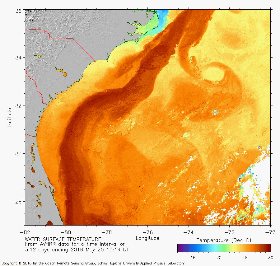
With shear being low and the system stalling over the Gulf Stream. What is supposed to hold it back from strengthening?
0 likes
My posts are not official forecasts. They are just my opinion and may or may not be backed by sound meteorological data. They are NOT endorsed by any professional institution or storm2k.org. For official information, please refer to the NHC and NWS products.
-
stormlover2013
-
tarheelprogrammer
- S2K Supporter
- Posts: 1793
- Joined: Mon Mar 28, 2016 9:25 pm
- Location: Raleigh, NC area (Garner, NC)
Re: ATL: INVEST 91L - Discussion
stormlover2013 wrote:its May lol, that's the hold back.......
Well of course lol my biggest thing is the Gulf Stream is mighty warm already. If it stalls over waters as warm as below and no shear why would it not strengthen has to be something else in play.
0 likes
My posts are not official forecasts. They are just my opinion and may or may not be backed by sound meteorological data. They are NOT endorsed by any professional institution or storm2k.org. For official information, please refer to the NHC and NWS products.
-
cycloneye
- Admin
- Posts: 149503
- Age: 69
- Joined: Thu Oct 10, 2002 10:54 am
- Location: San Juan, Puerto Rico
Re: ATL: INVEST 91L - Discussion
Nice surface reflection but needs plenty of convection.

0 likes
Visit the Caribbean-Central America Weather Thread where you can find at first post web cams,radars
and observations from Caribbean basin members Click Here
and observations from Caribbean basin members Click Here
-
stormlover2013
Re: ATL: INVEST 91L - Discussion
maybe it will you never know, going to be a ragged storm and you know how those are, always tough to get those to take off and develop quick.
0 likes
-
tarheelprogrammer
- S2K Supporter
- Posts: 1793
- Joined: Mon Mar 28, 2016 9:25 pm
- Location: Raleigh, NC area (Garner, NC)
Re: ATL: INVEST 91L - Discussion
stormlover2013 wrote:maybe it will you never know, going to be a ragged storm and you know how those are, always tough to get those to take off and develop quick.
Oh I could be wrong no doubt I am no MET and May is usually not favorable for TC strengthening but it has happened in the past as recently as 2012.
0 likes
My posts are not official forecasts. They are just my opinion and may or may not be backed by sound meteorological data. They are NOT endorsed by any professional institution or storm2k.org. For official information, please refer to the NHC and NWS products.

Re: ATL: INVEST 91L - Discussion
psyclone wrote:first naked swirl of the new year. popcorn. Could be a holiday weekend bummer for someone and certainly a reminder that the tropical season is upon us.
I'm super excited to see this. I've been lurking these forums for years, trying to learn what I can here and there. Just based on last years el nino and the historic warm temperatures, I've been giddy with excitement for months now.
I wish I knew anywhere near as much as you guys about how to read these maps, forecasting etc. Anyone have any suggestions for starting points?
0 likes
-
stormlover2013
Re: ATL: INVEST 91L - Discussion
to be honest its prob because it isn't a true tropical system.
0 likes
-
tarheelprogrammer
- S2K Supporter
- Posts: 1793
- Joined: Mon Mar 28, 2016 9:25 pm
- Location: Raleigh, NC area (Garner, NC)
Re: ATL: INVEST 91L - Discussion
stormlover2013 wrote:to be honest its prob because it isn't a true tropical system.
Didn't Joaquin start out as such last season?
0 likes
My posts are not official forecasts. They are just my opinion and may or may not be backed by sound meteorological data. They are NOT endorsed by any professional institution or storm2k.org. For official information, please refer to the NHC and NWS products.


Re: ATL: INVEST 91L - Discussion
Admins, please feel free to delete this if this isn't the board for this question.
Now that we have an invest, shouldn't it be showing up on the map at the top of the home page, instead of "No Active Storms"?
I could be wrong.
Now that we have an invest, shouldn't it be showing up on the map at the top of the home page, instead of "No Active Storms"?
I could be wrong.
0 likes
-
TCmet
- Professional-Met
- Posts: 106
- Age: 45
- Joined: Sat Jul 14, 2007 4:00 pm
- Location: New York, NY
- Contact:
Re: ATL: INVEST 91L - Discussion
Cuda wrote:
I wish I knew anywhere near as much as you guys about how to read these maps, forecasting etc. Anyone have any suggestions for starting points?
Welcome to the club, Cuda! Here's a great resource about tropical meteorology. Ignore the equations, etc, and there are a lot of really well-done graphics and explanations: http://www.goes-r.gov/users/comet/tropical/textbook_2nd_edition/print_1.htm
0 likes
-
TheStormExpert
Re: ATL: INVEST 91L - Discussion
tarheelprogrammer wrote:stormlover2013 wrote:maybe it will you never know, going to be a ragged storm and you know how those are, always tough to get those to take off and develop quick.
Oh I could be wrong no doubt I am no MET and May is usually not favorable for TC strengthening but it has happened in the past as recently as 2012.
It happened last season too with Ana trying to ramp up some as it approached the SC Coast.
0 likes
Who is online
Users browsing this forum: No registered users and 43 guests