ATL: COLIN - Post-Tropical - Discussion

Moderator: S2k Moderators

Message
Author
User avatar
northjaxpro
S2K Supporter
S2K Supporter
Posts: 8900
Joined: Mon Sep 27, 2010 11:21 am
Location: Jacksonville, FL

Re: ATL: COLIN - Tropical Storm - Discussion

#641 Postby northjaxpro » Sun Jun 05, 2016 6:56 pm

adam0983 wrote:Does anyone think tropical storm Colin will be a hurricane and what should we expect in Boca Raton


I don't think it will become a minimum hurricane in the GOM before landfall over the Big Bend region, but I think there is a brief, small window of opportunity, if shear is not decapitating, that Colin may attain Cat 1 status if he can get out into the Gulf Stream off the SE ATL coast before becoming extratropical during Tuesday.
0 likes   
NEVER, EVER SAY NEVER in the tropics and weather in general, and most importantly, with life itself!!

________________________________________________________________________________________

Fay 2008 Beryl 2012 Debby 2012 Colin 2016 Hermine 2016 Julia 2016 Matthew 2016 Irma 2017 Dorian 2019

Chris_in_Tampa
Category 5
Category 5
Posts: 5075
Age: 41
Joined: Thu Jun 21, 2007 11:06 pm
Location: Tampa, Florida, USA
Contact:

Re: ATL: COLIN - Tropical Storm - Discussion

#642 Postby Chris_in_Tampa » Sun Jun 05, 2016 6:57 pm

With 7pm CDT intermediate advisory position:

Image
0 likes   

User avatar
Nimbus
Category 5
Category 5
Posts: 5274
Joined: Mon Jul 19, 2004 10:54 am

Re: ATL: COLIN - Models

#643 Postby Nimbus » Sun Jun 05, 2016 7:01 pm

ronjon wrote:
gatorcane wrote:Wow GFS has trended stronger indeed, now strong TS in the NE Gulf. :eek:

Image


Looks to me on SAT that the upper level trough over SE Texas is weakening and retrograding slowly SW. This might be the reason GFS now showing strengthening.


So what will the upper air environment be like in 24 hours?
Hopefully that shear from the south will keep Colin from stacking up but the trough is no longer moving east.
0 likes   

User avatar
gatorcane
S2K Supporter
S2K Supporter
Posts: 23689
Age: 47
Joined: Sun Mar 13, 2005 3:54 pm
Location: Boca Raton, FL

Re: ATL: COLIN - Tropical Storm - Discussion

#644 Postby gatorcane » Sun Jun 05, 2016 7:07 pm

MLC looks vigorous and seems to be moving more NNE. Last frame before sun goes down

http://rammb.cira.colostate.edu/ramsdis ... display=12
0 likes   

User avatar
stormhunter7
Category 2
Category 2
Posts: 761
Joined: Mon May 26, 2008 3:13 pm
Location: Panama City Beach, Florida
Contact:

Re: ATL: COLIN - Tropical Storm - Discussion

#645 Postby stormhunter7 » Sun Jun 05, 2016 7:11 pm

0 likes   
The following post is NOT an official forecast and should not be used as such. It is just the opinion of the poster and may or may not be backed by sound meteorological data. It is NOT endorsed by any professional institution including storm2k.org For Official Information please refer to the NHC and NWS products. http://www.nhc.noaa.gov

psyclone
S2K Supporter
S2K Supporter
Posts: 4745
Joined: Wed Aug 24, 2005 9:04 pm
Location: palm harbor fl

Re: ATL: COLIN - Tropical Storm - Discussion

#646 Postby psyclone » Sun Jun 05, 2016 7:13 pm

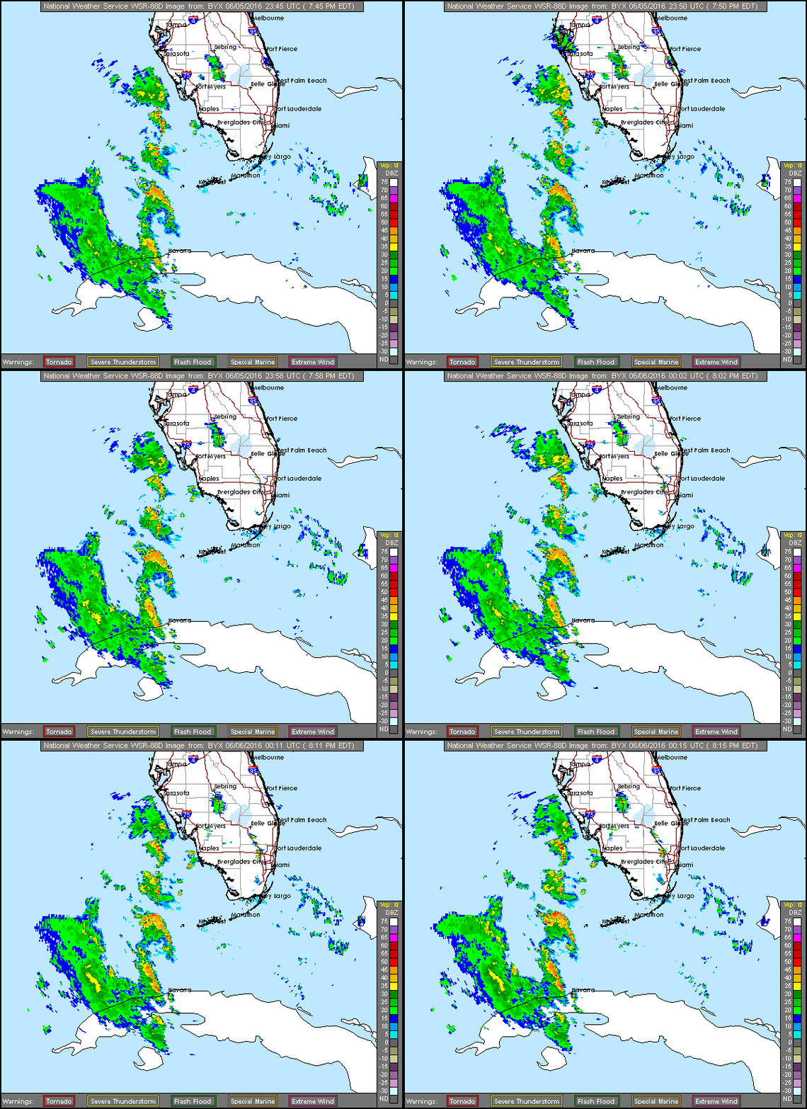
a non stop parade of squalls runs from Tampa Bay all the way to west of Havana. Gulf coast residents will need to time their dog walks carefully this evening
0 likes   

User avatar
tarheelprogrammer
S2K Supporter
S2K Supporter
Posts: 1793
Joined: Mon Mar 28, 2016 9:25 pm
Location: Raleigh, NC area (Garner, NC)

Re: ATL: COLIN - Tropical Storm - Discussion

#647 Postby tarheelprogrammer » Sun Jun 05, 2016 7:13 pm


Haircut time.
0 likes   
My posts are not official forecasts. They are just my opinion and may or may not be backed by sound meteorological data. They are NOT endorsed by any professional institution or storm2k.org. For official information, please refer to the NHC and NWS products.

User avatar
NDG
S2K Supporter
S2K Supporter
Posts: 15446
Joined: Sun Jul 09, 2006 10:14 pm
Location: Orlando, FL

Re: ATL: COLIN - Models

#648 Postby NDG » Sun Jun 05, 2016 7:14 pm

Nimbus wrote:
ronjon wrote:
gatorcane wrote:Wow GFS has trended stronger indeed, now strong TS in the NE Gulf. :eek:

http://i.imgur.com/2ISDtMy.png


Looks to me on SAT that the upper level trough over SE Texas is weakening and retrograding slowly SW. This might be the reason GFS now showing strengthening.


So what will the upper air environment be like in 24 hours?
Hopefully that shear from the south will keep Colin from stacking up but the trough is no longer moving east.


Here's the map for tomorrow evening, it looks like Colin will maintain the current UL environment, 20-30 knot windshear, moderate to strong but not that it will decapitate it.

Image
0 likes   

User avatar
NDG
S2K Supporter
S2K Supporter
Posts: 15446
Joined: Sun Jul 09, 2006 10:14 pm
Location: Orlando, FL

Re: ATL: COLIN - Tropical Storm - Discussion

#649 Postby NDG » Sun Jun 05, 2016 7:20 pm

tarheelprogrammer wrote:


Haircut time.


Guess what? Colin is not moving to the west into the stronger sheared area :)
0 likes   

User avatar
NDG
S2K Supporter
S2K Supporter
Posts: 15446
Joined: Sun Jul 09, 2006 10:14 pm
Location: Orlando, FL

Re: ATL: COLIN - Tropical Storm - Discussion

#650 Postby NDG » Sun Jun 05, 2016 7:21 pm

psyclone wrote:a non stop parade of squalls runs from Tampa Bay all the way to west of Havana. Gulf coast residents will need to time their dog walks carefully this evening


Indeed, a Havana-Tampa express.

Image
0 likes   

User avatar
tarheelprogrammer
S2K Supporter
S2K Supporter
Posts: 1793
Joined: Mon Mar 28, 2016 9:25 pm
Location: Raleigh, NC area (Garner, NC)

Re: ATL: COLIN - Tropical Storm - Discussion

#651 Postby tarheelprogrammer » Sun Jun 05, 2016 7:23 pm

NDG wrote:
tarheelprogrammer wrote:


Haircut time.


Guess what? Colin is not moving to the west into the stronger sheared area :)


True but what about the flight level winds that are in the 90 range above him? To the northeast?
0 likes   
My posts are not official forecasts. They are just my opinion and may or may not be backed by sound meteorological data. They are NOT endorsed by any professional institution or storm2k.org. For official information, please refer to the NHC and NWS products.

stormwise

Re: ATL: COLIN - Models

#652 Postby stormwise » Sun Jun 05, 2016 7:26 pm

Image
Image
Image
Image
Image

With out cherry picking.
0 likes   

tgenius
S2K Supporter
S2K Supporter
Posts: 1159
Joined: Mon May 15, 2006 5:31 pm
Location: Miami, FL

Re: ATL: COLIN - Tropical Storm - Discussion

#653 Postby tgenius » Sun Jun 05, 2016 7:27 pm

NDG wrote:
psyclone wrote:a non stop parade of squalls runs from Tampa Bay all the way to west of Havana. Gulf coast residents will need to time their dog walks carefully this evening


Indeed, a Havana-Tampa express.

Image


Based on the way that's shaping, Eastern South FL doesn't appear like it will get as much rain from Colin.
0 likes   

User avatar
NDG
S2K Supporter
S2K Supporter
Posts: 15446
Joined: Sun Jul 09, 2006 10:14 pm
Location: Orlando, FL

Re: ATL: COLIN - Tropical Storm - Discussion

#654 Postby NDG » Sun Jun 05, 2016 7:33 pm

tarheelprogrammer wrote:
NDG wrote:
tarheelprogrammer wrote:
Haircut time.


Guess what? Colin is not moving to the west into the stronger sheared area :)


True but what about the flight level winds that are in the 90 range above him? To the northeast?


I am sure they will relax some as the system moves northward and the UL anticyclone tries to move northward with it, or at least some portion of it.
0 likes   

User avatar
AdamFirst
S2K Supporter
S2K Supporter
Posts: 2491
Age: 36
Joined: Thu Aug 14, 2008 10:54 am
Location: Port Saint Lucie, FL

Re: ATL: COLIN - Tropical Storm - Discussion

#655 Postby AdamFirst » Sun Jun 05, 2016 7:33 pm

tgenius wrote:
Based on the way that's shaping, Eastern South FL doesn't appear like it will get as much rain from Colin.


As the mass and the associated energy pushes northeastward, Southeast Florida will get its share of rain and squalls, just not at the frequency of the west coast.

South Florida may see its heaviest rainfall later in the week after Colin is long gone due to the stalling trough.

Personal Forecast Disclaimer:
The posts in this forum are NOT official forecast and should not be used as such. They are just the opinion of the poster and may or may not be backed by sound meteorological data. They are NOT endorsed by any professional institution or storm2k.org. For official information, please refer to the NHC and NWS products.
0 likes   
Dolphins Marlins Canes Golden Panthers HEAT
Andrew 1992 - Irene 1999 - Frances 2004 - Jeanne 2004 - Wilma 2005 - Fay 2008 - Isaac 2012 - Matthew 2016 - Irma 2017 - Dorian 2019 - Ian 2022 - Nicole 2022 - Milton 2024

User avatar
northjaxpro
S2K Supporter
S2K Supporter
Posts: 8900
Joined: Mon Sep 27, 2010 11:21 am
Location: Jacksonville, FL

Re: ATL: COLIN - Tropical Storm - Discussion

#656 Postby northjaxpro » Sun Jun 05, 2016 7:46 pm

I could not resist posting the wide view of the Atlantic basin. It is remarkable to give you an idea just how large and massive this gyre is, as the deep tropical moisture is funneling all the way from the Eastern Pacific north/northeast to Colin in the Eastern Gulf of Mexico. Mother Nature's moisture pump truly in full effect, on satellite imagery.

Image

Image


Also you can see clearly how the upper trough over Northern Mexico continues to retrograde southwest for the time being, which is actually helping the cyclone ventilate and is keeping the decapitating shear away from Colin for the time being.
Last edited by northjaxpro on Sun Jun 05, 2016 7:59 pm, edited 2 times in total.
0 likes   
NEVER, EVER SAY NEVER in the tropics and weather in general, and most importantly, with life itself!!

________________________________________________________________________________________

Fay 2008 Beryl 2012 Debby 2012 Colin 2016 Hermine 2016 Julia 2016 Matthew 2016 Irma 2017 Dorian 2019

User avatar
tropicwatch
Category 5
Category 5
Posts: 3364
Age: 61
Joined: Sat Jun 02, 2007 10:01 am
Location: Panama City Florida
Contact:

Re: ATL: COLIN - Tropical Storm - Discussion

#657 Postby tropicwatch » Sun Jun 05, 2016 7:55 pm

:uarrow: The imagery above kind of gives the impression that the front is separating at the Louisiana, Arkansas and Mississippi state lines.
0 likes   
Tropicwatch


Agnes 72', Eloise 75, Elena 85', Kate 85', Charley 86', Florence 88', Beryl 94', Dean 95', Erin 95', Opal 95', Earl 98', Georges 98', Ivan 2004', Arlene 2005', Dennis 2005', Ida 2009' Debby 2012' Irma 2017' Michael 2018'

floridasun78
Category 5
Category 5
Posts: 3755
Joined: Sun May 17, 2009 10:16 pm
Location: miami fl

Re: ATL: COLIN - Tropical Storm - Discussion

#658 Postby floridasun78 » Sun Jun 05, 2016 7:57 pm

tgenius wrote:
NDG wrote:
psyclone wrote:a non stop parade of squalls runs from Tampa Bay all the way to west of Havana. Gulf coast residents will need to time their dog walks carefully this evening


Indeed, a Havana-Tampa express.

Image


Based on the way that's shaping, Eastern South FL doesn't appear like it will get as much rain from Colin.

i was say that look all rain staying off gulf coast moving north for now nws was expacting east coast get good rain from COLIN
0 likes   

CrazyC83
Professional-Met
Professional-Met
Posts: 34001
Joined: Tue Mar 07, 2006 11:57 pm
Location: Deep South, for the first time!

Re: ATL: COLIN - Recon

#659 Postby CrazyC83 » Sun Jun 05, 2016 7:58 pm

Next flight is tomorrow morning?
0 likes   

User avatar
cycloneye
Admin
Admin
Posts: 143877
Age: 68
Joined: Thu Oct 10, 2002 10:54 am
Location: San Juan, Puerto Rico

Re: ATL: COLIN - Recon

#660 Postby cycloneye » Sun Jun 05, 2016 8:02 pm

CrazyC83 wrote:Next flight is tomorrow morning?


Plane departs at 3:30z.

FLIGHT TWO -- TEAL 73
A. 06/0530Z,1130Z
B. AFXXX 0203A CYCLONE
C. 06/0330Z
D. 25.0N 87.2W
E. 06/0500Z TO 06/1130Z
F. SFC TO 10,000 FT
0 likes   
Visit the Caribbean-Central America Weather Thread where you can find at first post web cams,radars
and observations from Caribbean basin members Click Here


Return to “2016”

Who is online

Users browsing this forum: No registered users and 33 guests