ATL: JOSE - Models
Moderator: S2k Moderators
-
forecasterjack
- Tropical Storm

- Posts: 195
- Joined: Wed Aug 23, 2017 3:44 pm
Re: ATL: JOSE - Models
12Z EPS tracks for Jose: https://weather.us/cyclone-tracks/euro/ ... -jose.html
2 likes
-
floridasun78
- Category 5

- Posts: 3755
- Joined: Sun May 17, 2009 10:16 pm
- Location: miami fl

Re: ATL: JOSE - Models
Obviously it's crazy to put too much stock in models this far out, but 18Z GFS is showing an intriguing dance between Jose and Lee at day 13. Any precedents for that kind of interaction in this part of the Atlantic?
0 likes
Re: ATL: JOSE - Models
Does the Azores anticyclone more or less guarantee they're protected from a tropical storm striking from the west, or could some exotic interaction between Jose and Lee actually overcome that and lead at least one of those storms over the islands?
1 likes
-
WilmingtonSandbar
- S2K Supporter

- Posts: 505
- Joined: Sun Aug 29, 2010 12:11 pm
- Location: Southport, NC
Re: ATL: JOSE - Models
sflicht wrote:Obviously it's crazy to put too much stock in models this far out, but 18Z GFS is showing an intriguing dance between Jose and Lee at day 13. Any precedents for that kind of interaction in this part of the Atlantic?
Isn't that a Fujiwara effect depicted?
1 likes
Diana X2 (look it up), Bertha, Fran, Bonnie, Floyd, Dennis, Charley, Ophelia, Ernesto, Irene, Matthew, And Florence
-
ColdMiser123

- Professional-Met

- Posts: 905
- Age: 29
- Joined: Mon Sep 26, 2016 3:26 pm
- Location: Northeast US
Re: ATL: JOSE - Models
Way out there, but the 0z Euro wants to turn Jose into Jeanne 2.0.
Lots of options for Jose after Day 5.
Lots of options for Jose after Day 5.
0 likes
B.S., M.S., Meteorology & Atmospheric Science
-
wxmann_91

- Category 5
- Posts: 8007
- Age: 34
- Joined: Fri Jul 15, 2005 2:49 pm
- Location: Southern California
- Contact:
Re: ATL: JOSE - Models
This is in fantasy range for sure, but models and their ensembles do hint at building heights in the western Atlantic later next week...

0 likes
-
AtlanticWind

- S2K Supporter
- Posts: 1898
- Age: 67
- Joined: Sun Aug 08, 2004 9:57 pm
- Location: Plantation,Fla
Re: ATL: JOSE - Models
This would be a nightmare for us in florida ,another major hurricane?
3 likes
-
Digital-TC-Chaser
Re: ATL: JOSE - Models
Ryan MaueVerified account @RyanMaue 26m26 minutes ago
More
Hurricane Jose will need to be watched closely next week as steering currents collapse & storm may loop a la Jeanne [2004].

More
Hurricane Jose will need to be watched closely next week as steering currents collapse & storm may loop a la Jeanne [2004].
1 likes
-
TheStormExpert
Re: ATL: JOSE - Models
I seriously hope this is a bad case of the Euro being horrendous in its long-range like it's known to be this season. That's the last thing folks need in SE FL!
2 likes
-
EquusStorm
- Category 5
- Posts: 1649
- Age: 35
- Joined: Thu Nov 07, 2013 1:04 pm
- Location: Jasper, AL
- Contact:
Re: ATL: JOSE - Models
Category four Gulf hurricane hitting while RI followed by a long-lived, island-shredding, 'I'-named Cat 5 Cape Verde ACE churner heading generally for Florida and then a 'J'-named possible looping hit following fairly close behind? Is this 2004 or 2017??
Seriously though... I heard mention of a possible Lee on long range GFS earlier, how long is the ridging supposed to be this strong? It's really not good to have a Cape Verde train going while under super strong ridging, obviously
Seriously though... I heard mention of a possible Lee on long range GFS earlier, how long is the ridging supposed to be this strong? It's really not good to have a Cape Verde train going while under super strong ridging, obviously
3 likes
Colors of lost purpose on the canvas of irrelevance
Not a meteorologist, in fact more of an idiot than anything. You should probably check with the NHC or a local NWS office for official information.
Not a meteorologist, in fact more of an idiot than anything. You should probably check with the NHC or a local NWS office for official information.
-
northjaxpro

- S2K Supporter
- Posts: 8900
- Joined: Mon Sep 27, 2010 11:21 am
- Location: Jacksonville, FL
Re: ATL: JOSE - Models
GOD FORBID!!!!!!!!!
A double whammy of two major hurricanes impacting Florida within 10 days??
Oh my heavens?? I freaked out seeing the latest 0Z EURO run.
A Jeanne '04 type scenario Part 2 in the making? The Ridge building right back in to steer Jose back at the Bahamas and Florida? This would be a complete nightmare if this verified.
1 likes
NEVER, EVER SAY NEVER in the tropics and weather in general, and most importantly, with life itself!!
________________________________________________________________________________________
Fay 2008 Beryl 2012 Debby 2012 Colin 2016 Hermine 2016 Julia 2016 Matthew 2016 Irma 2017 Dorian 2019
________________________________________________________________________________________
Fay 2008 Beryl 2012 Debby 2012 Colin 2016 Hermine 2016 Julia 2016 Matthew 2016 Irma 2017 Dorian 2019
-
Digital-TC-Chaser
Re: ATL: JOSE - Models
TheStormExpert wrote:I seriously hope this is a bad case of the Euro being horrendous in its long-range like it's known to be this season. That's the last thing folks need in SE FL!
Alot of people would be hoping maybe its just as you say the ec being horrendous @L/R.
If not who know's some real estate may become uninhabitable for years.
0 likes
-
USTropics
- Professional-Met
- Posts: 2737
- Joined: Sun Aug 12, 2007 3:45 am
- Location: Florida State University
Re: ATL: JOSE - Models
Quite a few ECMWF ensembles are showing Jose doing an anti-cyclonic loop:

0 likes
-
Nightwatch

- Tropical Storm
- Posts: 107
- Joined: Thu Aug 04, 2011 6:58 am
Re: ATL: JOSE - Models
Jose seems to shift further west every single day...
1 likes
The only thing we really get for free is the weather...

Re: ATL: JOSE - Models

0 likes
Igor 2010, Sandy 2012, Fay 2014, Gonzalo 2014, Joaquin 2015, Nicole 2016, Humberto 2019, Imelda 2025
I am only a tropical weather enthusiast. My predictions are not official and may or may not be backed by sound meteorological data. For official information, please refer to the NHC and NWS products.
I am only a tropical weather enthusiast. My predictions are not official and may or may not be backed by sound meteorological data. For official information, please refer to the NHC and NWS products.

Re: ATL: JOSE - Models
Insult to injury that the models are trending towards Jose tracking over or close to the Leeward Islands, unreal.
1 likes
-
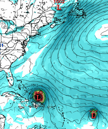
tolakram
- Admin

- Posts: 20179
- Age: 62
- Joined: Sun Aug 27, 2006 8:23 pm
- Location: Florence, KY (name is Mark)
Re: ATL: JOSE - Models
0Z Euro loop solution

0 likes
M a r k
- - - - -
Join us in chat: Storm2K Chatroom Invite. Android and IOS apps also available.
The posts in this forum are NOT official forecasts and should not be used as such. Posts are NOT endorsed by any professional institution or STORM2K.org. For official information and forecasts, please refer to NHC and NWS products.
-
TheDreamTraveler

- Category 2

- Posts: 645
- Joined: Sun Aug 22, 2010 3:10 am
- Location: PA
Re: ATL: JOSE - Models
I guess the Euro is showing Jose making a cyclonic loop near Florida just like the GFS did a few days ago. People better pay attention to this just in case. I know people are still talking about Harvey and now Irma, but this could be bad also.
0 likes

Re: ATL: INVEST 94L - Models
Michele B wrote:Yes, I watched this loop!
Not sure how to embed.
Just wrap it in image tags like you would any other type of image. That's what I did above.
0 likes
Who is online
Users browsing this forum: No registered users and 92 guests