ATL: DORIAN - Models

Moderator: S2k Moderators

Message
Author
Ken711
Category 5
Category 5
Posts: 1074
Joined: Tue Aug 28, 2012 12:48 pm

Re: ATL: DORIAN - Models

#4681 Postby Ken711 » Sat Aug 31, 2019 11:14 am

norva13x wrote:Looks like a trend west for current model runs. Hopefully it doesn't continue. Not out of the woods.


Nobody out off the woods in any respect from Florida to Virginia.
2 likes   

hohnywx
Category 2
Category 2
Posts: 508
Age: 34
Joined: Sun Jul 19, 2009 8:34 pm
Location: Hastings-on-Hudson, NY

Re: ATL: DORIAN - Models

#4682 Postby hohnywx » Sat Aug 31, 2019 11:14 am

KWT wrote:The UKMO is still offshore but got to say, thats really not that far from brushing the east coast of Florida on that 12z, a fairly close approach and wouldn't take much of a westward shift to bring the eyewall close to the coast....


And it seems to have come westward from its previous run.
0 likes   

Ian2401
Category 1
Category 1
Posts: 307
Joined: Thu Sep 14, 2017 5:55 pm
Location: Tallahassee, Florida
Contact:

Re: ATL: DORIAN - Models

#4683 Postby Ian2401 » Sat Aug 31, 2019 11:15 am

CMC running now, initialized slightly S and slower at 12 hours
0 likes   
B.S. Meteorology from Florida State '24 // Current M.S. Meteorology student at Florida State

Research Interests: Rapid Intensification, TC Climatology, TC Modeling

Consult the NHC for official information

LarryWx
S2K Supporter
S2K Supporter
Posts: 6321
Joined: Sun Sep 07, 2003 2:04 pm
Location: GA

Re: ATL: DORIAN - Models

#4684 Postby LarryWx » Sat Aug 31, 2019 11:19 am

CMC headed to Canaveral
0 likes   
Personal Forecast Disclaimer:
The posts in this forum are NOT official forecasts and should not be used as such. They are just the opinion of the poster and may or may not be backed by sound meteorological data. They are NOT endorsed by any professional institution or storm2k.org. For official information, please refer to the NHC and NWS products.

Javlin
Category 5
Category 5
Posts: 1620
Age: 64
Joined: Fri Jul 09, 2004 7:58 pm
Location: ms gulf coast

Re: ATL: DORIAN - Models

#4685 Postby Javlin » Sat Aug 31, 2019 11:20 am

Cimss steering layer looks due W for a while with a stronger ridge to the N how long that holds out is another question but Dorian is on the move today.

http://tropic.ssec.wisc.edu/real-time/d ... oom=&time=
4 likes   

Aric Dunn
Category 5
Category 5
Posts: 21238
Age: 42
Joined: Sun Sep 19, 2004 9:58 pm
Location: Ready for the Chase.
Contact:

Re: ATL: DORIAN - Models

#4686 Postby Aric Dunn » Sat Aug 31, 2019 11:22 am

LarryWx wrote:CMC headed to Canaveral


yeah it has west motion for about 12 hours then turns wnw.. allowing it to get to the coast with the gradual turn.
0 likes   
Note: If I make a post that is brief. Please refer back to previous posts for the analysis or reasoning. I do not re-write/qoute what my initial post said each time.
If there is nothing before... then just ask :)

Space & Atmospheric Physicist, Embry-Riddle Aeronautical University,
I believe the sky is falling...

b0tzy29
Tropical Depression
Tropical Depression
Posts: 65
Joined: Sun Sep 02, 2018 9:03 am

Re: ATL: DORIAN - Models

#4687 Postby b0tzy29 » Sat Aug 31, 2019 11:23 am

Lets hope this isnt the beginning of a trend. I see a slight shift south and west. This is going to be so close guys.

Image
3 likes   

LarryWx
S2K Supporter
S2K Supporter
Posts: 6321
Joined: Sun Sep 07, 2003 2:04 pm
Location: GA

Re: ATL: DORIAN - Models

#4688 Postby LarryWx » Sat Aug 31, 2019 11:24 am

Aric Dunn wrote:
LarryWx wrote:CMC headed to Canaveral


yeah it has west motion for about 12 hours then turns wnw.. allowing it to get to the coast with the gradual turn.


Next frame (54), CMC turns west just offshore Melbourne! Then stalls barely offshore.
Last edited by LarryWx on Sat Aug 31, 2019 11:25 am, edited 1 time in total.
1 likes   
Personal Forecast Disclaimer:
The posts in this forum are NOT official forecasts and should not be used as such. They are just the opinion of the poster and may or may not be backed by sound meteorological data. They are NOT endorsed by any professional institution or storm2k.org. For official information, please refer to the NHC and NWS products.

User avatar
gatorcane
S2K Supporter
S2K Supporter
Posts: 23691
Age: 47
Joined: Sun Mar 13, 2005 3:54 pm
Location: Boca Raton, FL

Re: ATL: DORIAN - Models

#4689 Postby gatorcane » Sat Aug 31, 2019 11:25 am

CMC looks to have Dorian way too weak
0 likes   

beachman80

Re: ATL: DORIAN - Models

#4690 Postby beachman80 » Sat Aug 31, 2019 11:26 am

Good thing CMC is not very reliable. It’s been horrible with storms. About as bad as ICON and NAVGEM.
0 likes   

User avatar
Blinhart
Category 5
Category 5
Posts: 2081
Age: 48
Joined: Thu Sep 08, 2011 3:13 pm
Location: Crowley, La.

Re: ATL: DORIAN - Models

#4691 Postby Blinhart » Sat Aug 31, 2019 11:26 am

TheDreamTraveler wrote:
Airboy wrote:So the ICON have a stronger ridge forcing it in and up Florida as I can understand it.


Icon isn't a very good model so I wouldn't put much weight into it.


Really cant say that, since it is a new model.
0 likes   
Personal Forecast Disclaimer:
The posts in this forum are NOT official forecast and should not be used as such. They are just the opinion of the poster and may or may not be backed by sound meteorological data. They are NOT endorsed by any professional institution or storm2k.org. For official information, please refer to the NHC and NWS products.

User avatar
NDG
S2K Supporter
S2K Supporter
Posts: 15446
Joined: Sun Jul 09, 2006 10:14 pm
Location: Orlando, FL

Re: ATL: DORIAN - Models

#4692 Postby NDG » Sat Aug 31, 2019 11:27 am

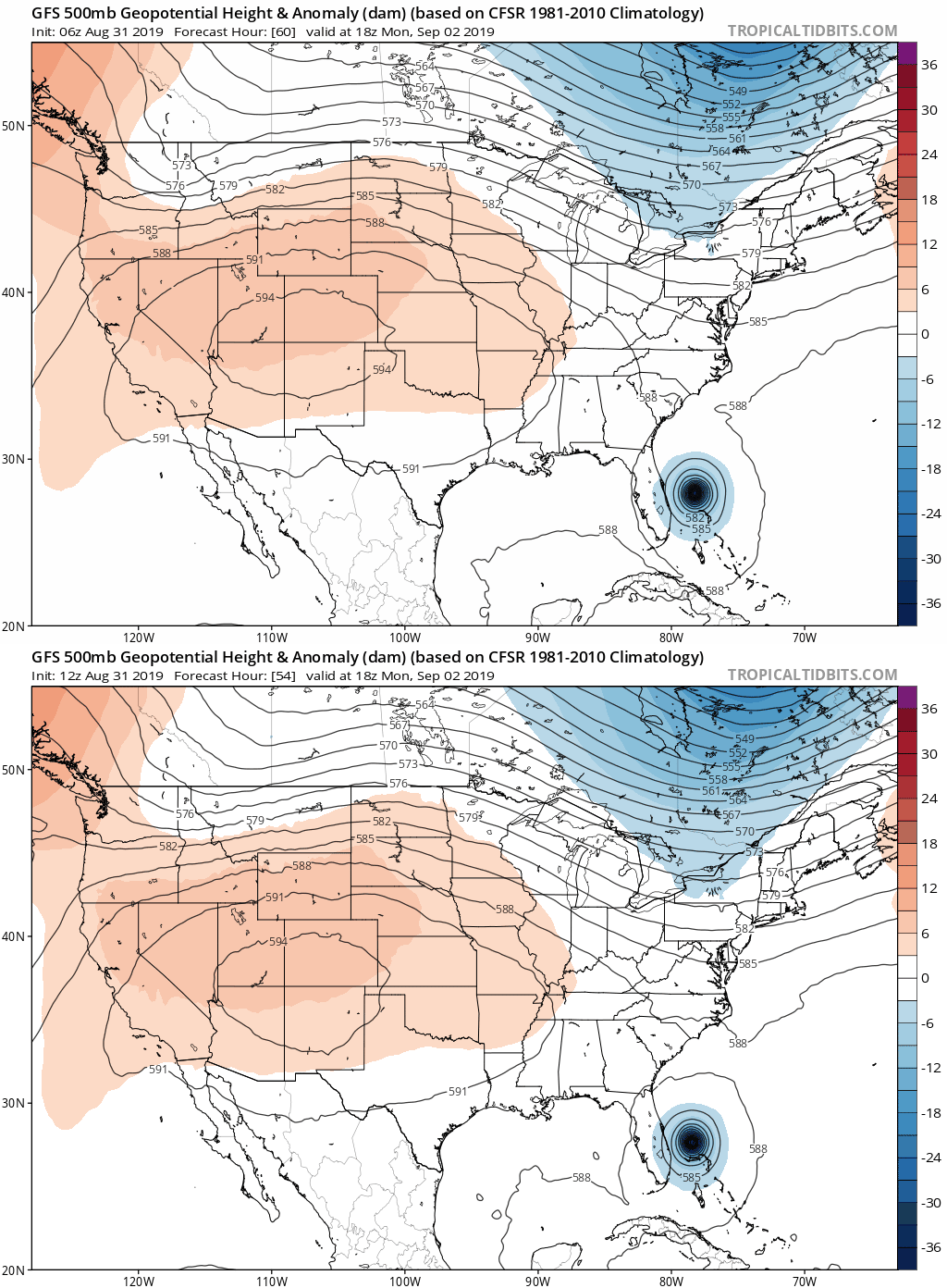
For whatever is worth, but a trend is a trend.

Image
0 likes   

LarryWx
S2K Supporter
S2K Supporter
Posts: 6321
Joined: Sun Sep 07, 2003 2:04 pm
Location: GA

Re: ATL: DORIAN - Models

#4693 Postby LarryWx » Sat Aug 31, 2019 11:28 am

CMC actual LF barely N of Canaveral at 72.
0 likes   
Personal Forecast Disclaimer:
The posts in this forum are NOT official forecasts and should not be used as such. They are just the opinion of the poster and may or may not be backed by sound meteorological data. They are NOT endorsed by any professional institution or storm2k.org. For official information, please refer to the NHC and NWS products.

User avatar
tronbunny
S2K Supporter
S2K Supporter
Posts: 1558
Joined: Wed Sep 01, 2004 1:18 am
Location: Central FL

Re: ATL: DORIAN - Models

#4694 Postby tronbunny » Sat Aug 31, 2019 11:29 am

ronjon wrote:12z ICON moves it N-NW up the spine of Florida after landfall in Ft Laud. What might be a trend to look at is ICON brings it south of the northern Bahama islands and doesn't stall it like the Euro. Second longer term trend is look at the strengthening 500mb ridge south of Bermuda and east of the storm in days 4-5. This massive ridge is expanding and extending all the way to almost the NC coast and keeping the storm from recurving until it reaches north Florida on this run.

https://www.tropicaltidbits.com/analysis/models/?model=icon&region=us&pkg=z500_mslp&runtime=2019083112&fh=3

This is the same ICON model that saw Dorian east of PR before others?
2 likes   

catskillfire51
S2K Supporter
S2K Supporter
Posts: 480
Age: 38
Joined: Sun Aug 26, 2012 5:40 pm
Location: Lake Jackson, TX

Re: ATL: DORIAN - Models

#4695 Postby catskillfire51 » Sat Aug 31, 2019 11:30 am

tronbunny wrote:
ronjon wrote:12z ICON moves it N-NW up the spine of Florida after landfall in Ft Laud. What might be a trend to look at is ICON brings it south of the northern Bahama islands and doesn't stall it like the Euro. Second longer term trend is look at the strengthening 500mb ridge south of Bermuda and east of the storm in days 4-5. This massive ridge is expanding and extending all the way to almost the NC coast and keeping the storm from recurving until it reaches north Florida on this run.

https://www.tropicaltidbits.com/analysis/models/?model=icon&region=us&pkg=z500_mslp&runtime=2019083112&fh=3

This is the same ICON model that saw Dorien east of PR before others?


Yes
0 likes   

Kat5
Tropical Storm
Tropical Storm
Posts: 178
Joined: Tue Jul 07, 2009 5:28 pm

Re: ATL: DORIAN - Models

#4696 Postby Kat5 » Sat Aug 31, 2019 11:32 am

beachman80 wrote:Good thing CMC is not very reliable. It’s been horrible with storms. About as bad as ICON and NAVGEM.


I consider it reliable as an early indicator of height changes. Definitely not on intensity, and exact positioning.
0 likes   

User avatar
SouthFLTropics
Category 5
Category 5
Posts: 4236
Age: 50
Joined: Thu Aug 14, 2003 8:04 am
Location: Port St. Lucie, Florida

Re: ATL: DORIAN - Models

#4697 Postby SouthFLTropics » Sat Aug 31, 2019 11:34 am

HWRF is running and is a bit sw of 06z as well.
0 likes   
Fourth Generation Florida Native

Personal Storm History: David 79, Andrew 92, Erin 95, Floyd 99, Irene 99, Frances 04, Jeanne 04, Wilma 05, Matthew 16, Irma 17, Ian 22, Nicole 22, Milton 24

User avatar
gatorcane
S2K Supporter
S2K Supporter
Posts: 23691
Age: 47
Joined: Sun Mar 13, 2005 3:54 pm
Location: Boca Raton, FL

Re: ATL: DORIAN - Models

#4698 Postby gatorcane » Sat Aug 31, 2019 11:34 am

Note the ICON shifted SW a decent amount. There are some Euro ensembles that show something similar.
3 likes   

User avatar
Blown Away
S2K Supporter
S2K Supporter
Posts: 10147
Joined: Wed May 26, 2004 6:17 am

Re: ATL: DORIAN - Models

#4699 Postby Blown Away » Sat Aug 31, 2019 11:37 am

12z HWRF @30-40 miles SW of 06z at @9 hours...
0 likes   
Hurricane Eye Experience: David 79, Irene 99, Frances 04, Jeanne 04, Wilma 05... EYE COMING MY WAY IN 2024…
Hurricane Brush Experience: Andrew 92, Erin 95, Floyd 99, Matthew 16, Irma 17, Ian 22, Nicole 22…

Shell Mound
Category 5
Category 5
Posts: 2434
Age: 32
Joined: Thu Sep 07, 2017 3:39 pm
Location: St. Petersburg, FL → Scandinavia

Re: ATL: DORIAN - Models

#4700 Postby Shell Mound » Sat Aug 31, 2019 11:37 am

The ICON has consistently displayed a southwesterly bias with DORIAN near FL because it unrealistically deepens the system in the Gulf, hence shortwave ridging.

The slight SW shifts by reliable global models won't change the outcome beyond the northern Bahamas. OTS is still heavily favoured after the Bahamas.
Last edited by Shell Mound on Sat Aug 31, 2019 11:40 am, edited 1 time in total.
3 likes   
CVW / MiamiensisWx / Shell Mound
The posts in this forum are NOT official forecasts and should not be used as such. They are just the opinion of the poster and may or may not be backed by sound meteorological data. They are NOT endorsed by any professional institution or STORM2K. For official information, please refer to products from the NHC and NWS.


Return to “2019”

Who is online

Users browsing this forum: No registered users and 3 guests