norva13x wrote:Looks like a trend west for current model runs. Hopefully it doesn't continue. Not out of the woods.
Nobody out off the woods in any respect from Florida to Virginia.
Moderator: S2k Moderators
norva13x wrote:Looks like a trend west for current model runs. Hopefully it doesn't continue. Not out of the woods.

KWT wrote:The UKMO is still offshore but got to say, thats really not that far from brushing the east coast of Florida on that 12z, a fairly close approach and wouldn't take much of a westward shift to bring the eyewall close to the coast....


LarryWx wrote:CMC headed to Canaveral
Aric Dunn wrote:LarryWx wrote:CMC headed to Canaveral
yeah it has west motion for about 12 hours then turns wnw.. allowing it to get to the coast with the gradual turn.
TheDreamTraveler wrote:Airboy wrote:So the ICON have a stronger ridge forcing it in and up Florida as I can understand it.
Icon isn't a very good model so I wouldn't put much weight into it.
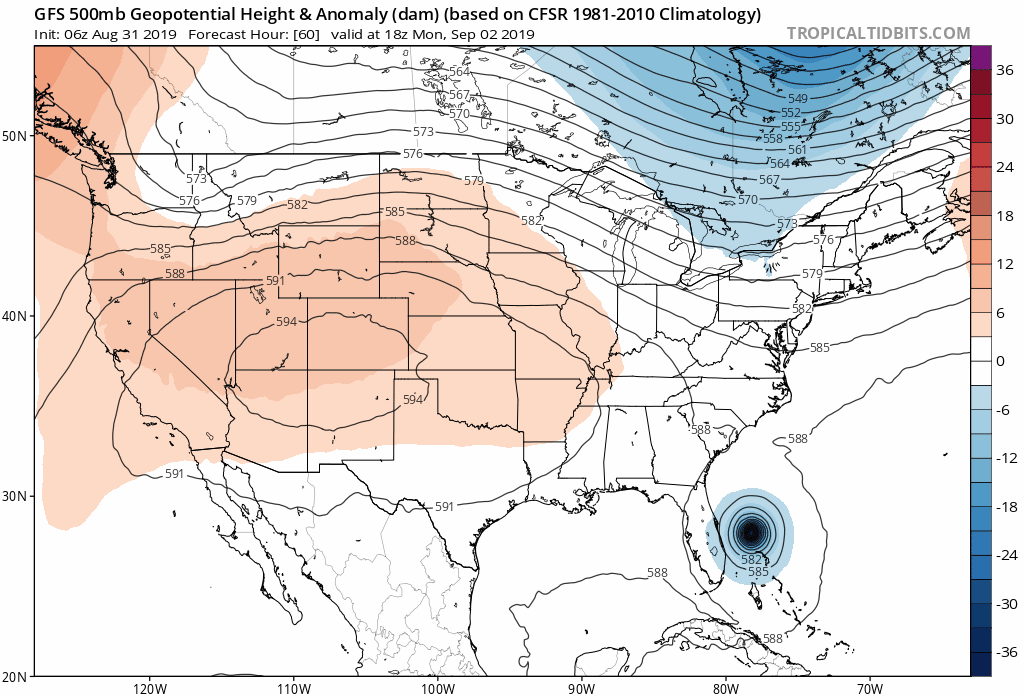
ronjon wrote:12z ICON moves it N-NW up the spine of Florida after landfall in Ft Laud. What might be a trend to look at is ICON brings it south of the northern Bahama islands and doesn't stall it like the Euro. Second longer term trend is look at the strengthening 500mb ridge south of Bermuda and east of the storm in days 4-5. This massive ridge is expanding and extending all the way to almost the NC coast and keeping the storm from recurving until it reaches north Florida on this run.
https://www.tropicaltidbits.com/analysis/models/?model=icon®ion=us&pkg=z500_mslp&runtime=2019083112&fh=3

tronbunny wrote:ronjon wrote:12z ICON moves it N-NW up the spine of Florida after landfall in Ft Laud. What might be a trend to look at is ICON brings it south of the northern Bahama islands and doesn't stall it like the Euro. Second longer term trend is look at the strengthening 500mb ridge south of Bermuda and east of the storm in days 4-5. This massive ridge is expanding and extending all the way to almost the NC coast and keeping the storm from recurving until it reaches north Florida on this run.
https://www.tropicaltidbits.com/analysis/models/?model=icon®ion=us&pkg=z500_mslp&runtime=2019083112&fh=3
This is the same ICON model that saw Dorien east of PR before others?
beachman80 wrote:Good thing CMC is not very reliable. It’s been horrible with storms. About as bad as ICON and NAVGEM.


Users browsing this forum: No registered users and 33 guests


