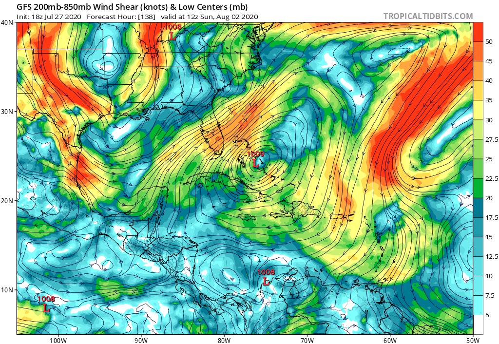
ATL: ISAIAS - Models

Moderator: S2k Moderators

Message
Author
User avatar
CM2
Tropical Storm
Tropical Storm
Posts: 103
Joined: Sun Jul 26, 2020 2:41 am

Re: ATL: INVEST 92L - Models

#621 Postby CM2 » Mon Jul 27, 2020 5:14 pm

St0rmTh0r wrote:
CM2 wrote:Though the GFS has been trash, what is interesting note is that for the first time in 10 runs, the trend is now back to a stronger storm than the previous run which hasn't happen in 10 runs. One thing to appreciate from models, even as trash as the GFS, is the trend they put together. Individual model runs are always garbage but the trend is always very telling.
https://imgur.com/PLPUOQu
The GFS 18z is still running so this is just the first thing I noticed in its early stages,

Was it the GFS that showed this storm weeks ago? I remember some model run showing a massive wave like this.

Both the Euro and the GEM both showed this wave forming into something, but nothing impressive. Nothing was shown last monday but they first started spotting 92L tuesday around 12z.

0 likes   
Large Signatures are for losers.
The posts in this forum are NOT official forecasts and should not be used as such. They are just the opinion of the poster and may or may not be backed by sound meteorological data. They are NOT endorsed by any professional institution or STORM2K. For official information, please refer to products from the NHC and NWS.

User avatar
gatorcane
S2K Supporter
S2K Supporter
Posts: 23691
Age: 47
Joined: Sun Mar 13, 2005 3:54 pm
Location: Boca Raton, FL

Re: ATL: INVEST 92L - Models

#622 Postby gatorcane » Mon Jul 27, 2020 5:16 pm

HUGE shift west by the 18Z GFS. It actually shows a favorable upper-level wind pattern with the low-level vorticity crawling WNW to NW over the Bahamas yet no development. When I say crawling I mean really slow. Not really something I want to see to start August:

Image
3 likes   

User avatar
toad strangler
S2K Supporter
S2K Supporter
Posts: 4543
Joined: Sun Jul 28, 2013 3:09 pm
Location: Earth
Contact:

Re: ATL: INVEST 92L - Models

#623 Postby toad strangler » Mon Jul 27, 2020 5:18 pm

gatorcane wrote:HUGE shift west by the 18Z GFS. It actually shows a favorable upper-level wind pattern with the low-level vorticity crawling WNW to NW over the Bahamas yet no development. Not really something I want to see to start August:

https://i.postimg.cc/N0mSJrNb/gfs-shear-watl-24.png


Stole my thunder. Huge GFS shift. Or shall I say cave.
Last edited by toad strangler on Mon Jul 27, 2020 5:22 pm, edited 1 time in total.
0 likes   

User avatar
gatorcane
S2K Supporter
S2K Supporter
Posts: 23691
Age: 47
Joined: Sun Mar 13, 2005 3:54 pm
Location: Boca Raton, FL

Re: ATL: INVEST 92L - Models

#624 Postby gatorcane » Mon Jul 27, 2020 5:21 pm

Looks like the GFS has more ridging as well which drives it into Florida but with little development despite a very favorable upper-level pattern over some of the hottest SSTs in the basin:

Image
Image
3 likes   

SconnieCane
Category 4
Category 4
Posts: 998
Joined: Thu Aug 02, 2018 5:29 pm
Location: Madison, WI

Re: ATL: INVEST 92L - Models

#625 Postby SconnieCane » Mon Jul 27, 2020 5:23 pm

gatorcane wrote:Looks like the GFS has more ridging as well which drives it into Florida but with little development despite a very favorable upper-level pattern over some of the hottest SSTs in the basin:

https://i.postimg.cc/L5wVFx5P/gfs-z500a-Norm-watl-29.png


Well THAT makes sense...

Thanks, GFS.
0 likes   

User avatar
SouthFLTropics
Category 5
Category 5
Posts: 4236
Age: 50
Joined: Thu Aug 14, 2003 8:04 am
Location: Port St. Lucie, Florida

Re: ATL: INVEST 92L - Models

#626 Postby SouthFLTropics » Mon Jul 27, 2020 5:23 pm

gatorcane wrote:HUGE shift west by the 18Z GFS. It actually shows a favorable upper-level wind pattern with the low-level vorticity crawling WNW to NW over the Bahamas yet no development. When I say crawling I mean really slow. Not really something I want to see to start August:

Image

Ugh...crawling. Dorian II THE SEQUAL. Let’s hope it stays this small blip on the radar. Although I have NO CONFIDENCE whatsoever in the models ability to forecast strength. Especially after that Hanna nonsense a few days ago.


Sent from my iPhone using Tapatalk
2 likes   
Fourth Generation Florida Native

Personal Storm History: David 79, Andrew 92, Erin 95, Floyd 99, Irene 99, Frances 04, Jeanne 04, Wilma 05, Matthew 16, Irma 17, Ian 22, Nicole 22, Milton 24

User avatar
DestinHurricane
Category 4
Category 4
Posts: 935
Joined: Tue May 01, 2018 8:05 am
Location: New York, NY

Re: ATL: INVEST 92L - Models

#627 Postby DestinHurricane » Mon Jul 27, 2020 5:23 pm

gatorcane wrote:Looks like the GFS has more ridging as well which drives it into Florida but with little development despite a very favorable upper-level pattern over some of the hottest SSTs in the basin:

https://i.postimg.cc/L5wVFx5P/gfs-z500a-Norm-watl-29.png


What is inhibiting development on this GFS?
2 likes   
Michael 2018

User avatar
Ubuntwo
Category 5
Category 5
Posts: 1406
Age: 31
Joined: Thu Oct 05, 2017 10:41 pm

Re: ATL: INVEST 92L - Models

#628 Postby Ubuntwo » Mon Jul 27, 2020 5:24 pm

DestinHurricane wrote:
gatorcane wrote:Looks like the GFS has more ridging as well which drives it into Florida but with little development despite a very favorable upper-level pattern over some of the hottest SSTs in the basin:

https://i.postimg.cc/L5wVFx5P/gfs-z500a-Norm-watl-29.png


What is inhibiting development on this GFS?

In this run, just dry air. It's got a persistent anticyclone so shear is no problem.
2 likes   
Kendall -> SLO -> PBC

Memorable Storms: Katrina (for its Florida landfall...) Wilma Matthew Irma

User avatar
CM2
Tropical Storm
Tropical Storm
Posts: 103
Joined: Sun Jul 26, 2020 2:41 am

Re: ATL: INVEST 92L - Models

#629 Postby CM2 » Mon Jul 27, 2020 5:24 pm

gatorcane wrote:HUGE shift west by the 18Z GFS. It actually shows a favorable upper-level wind pattern with the low-level vorticity crawling WNW to NW over the Bahamas yet no development. When I say crawling I mean really slow. Not really something I want to see to start August:

https://i.postimg.cc/N0mSJrNb/gfs-shear-watl-24.png

I saw the GFS, it's still a Yikes after 120 hours. There's just no consistency with the GFS in terms of structures and it just seems to change quite radically after each run. If I could, I would make it illegal to post GFS (Para would be acceptable) after 120 hours. It's just been that bad this season with long term forecasting.
1 likes   
Large Signatures are for losers.
The posts in this forum are NOT official forecasts and should not be used as such. They are just the opinion of the poster and may or may not be backed by sound meteorological data. They are NOT endorsed by any professional institution or STORM2K. For official information, please refer to products from the NHC and NWS.

User avatar
SouthFLTropics
Category 5
Category 5
Posts: 4236
Age: 50
Joined: Thu Aug 14, 2003 8:04 am
Location: Port St. Lucie, Florida

Re: ATL: INVEST 92L - Models

#630 Postby SouthFLTropics » Mon Jul 27, 2020 5:25 pm

Leave it to the 18z “happy hour” version of the GFS to shake things up a bit.


Sent from my iPhone using Tapatalk
1 likes   
Fourth Generation Florida Native

Personal Storm History: David 79, Andrew 92, Erin 95, Floyd 99, Irene 99, Frances 04, Jeanne 04, Wilma 05, Matthew 16, Irma 17, Ian 22, Nicole 22, Milton 24

User avatar
Evil Jeremy
S2K Supporter
S2K Supporter
Posts: 5463
Age: 32
Joined: Mon Apr 10, 2006 2:10 pm
Location: Los Angeles, CA

Re: ATL: INVEST 92L - Models

#631 Postby Evil Jeremy » Mon Jul 27, 2020 5:27 pm

GFS takes a barely closed low into WPB. Big shift from last day of GFS runs, but let's see if it bounces back East on the 00z.
2 likes   
Frances 04 / Jeanne 04 / Katrina 05 / Wilma 05 / Fay 08 / Debby 12 / Andrea 13 / Colin 16 / Hermine 16 / Matthew 16 / Irma 17

User avatar
toad strangler
S2K Supporter
S2K Supporter
Posts: 4543
Joined: Sun Jul 28, 2013 3:09 pm
Location: Earth
Contact:

Re: ATL: INVEST 92L - Models

#632 Postby toad strangler » Mon Jul 27, 2020 5:28 pm

SouthFLTropics wrote:Leave it to the 18z “happy hour” version of the GFS to shake things up a bit.


Sent from my iPhone using Tapatalk


To me, Euro has had the most plausible scenarios for awhile now, even with the N shift at 12z.
0 likes   

User avatar
SouthFLTropics
Category 5
Category 5
Posts: 4236
Age: 50
Joined: Thu Aug 14, 2003 8:04 am
Location: Port St. Lucie, Florida

Re: ATL: INVEST 92L - Models

#633 Postby SouthFLTropics » Mon Jul 27, 2020 5:29 pm

Evil Jeremy wrote:GFS takes a barely closed low into WPB. Big shift from last day of GFS runs, but let's see if it bounces back East on the 00z.

I’ve seen this movie before. It didn’t end well for the Northern Bahamas.


Sent from my iPhone using Tapatalk
1 likes   
Fourth Generation Florida Native

Personal Storm History: David 79, Andrew 92, Erin 95, Floyd 99, Irene 99, Frances 04, Jeanne 04, Wilma 05, Matthew 16, Irma 17, Ian 22, Nicole 22, Milton 24

Aric Dunn
Category 5
Category 5
Posts: 21238
Age: 42
Joined: Sun Sep 19, 2004 9:58 pm
Location: Ready for the Chase.
Contact:

Re: ATL: INVEST 92L - Models

#634 Postby Aric Dunn » Mon Jul 27, 2020 5:30 pm

Hey how are those trends going for everyone ?? :D
10 likes   
Note: If I make a post that is brief. Please refer back to previous posts for the analysis or reasoning. I do not re-write/qoute what my initial post said each time.
If there is nothing before... then just ask :)

Space & Atmospheric Physicist, Embry-Riddle Aeronautical University,
I believe the sky is falling...

AutoPenalti
Category 5
Category 5
Posts: 4030
Age: 29
Joined: Mon Aug 17, 2015 4:16 pm
Location: Ft. Lauderdale, Florida

Re: ATL: INVEST 92L - Models

#635 Postby AutoPenalti » Mon Jul 27, 2020 5:31 pm

Happy hour GFS is not so happy about forming 92L
0 likes   
The posts in this forum are NOT official forecasts and should not be used as such. They are just the opinion of the poster and may or may not be backed by sound meteorological data. They are NOT endorsed by any professional institution or STORM2K. For official information, please refer to products from the NHC and NWS.


Model Runs Cheat Sheet:
GFS (5:30 AM/PM, 11:30 AM/PM)
HWRF, GFDL, UKMET, NAVGEM (6:30-8:00 AM/PM, 12:30-2:00 AM/PM)
ECMWF (1:45 AM/PM)

TCVN
is a weighted averaged

User avatar
AdamFirst
S2K Supporter
S2K Supporter
Posts: 2491
Age: 36
Joined: Thu Aug 14, 2008 10:54 am
Location: Port Saint Lucie, FL

Re: ATL: INVEST 92L - Models

#636 Postby AdamFirst » Mon Jul 27, 2020 5:31 pm

Aric Dunn wrote:Hey how are those trends going for everyone ?? :D


I'm ready for naked swirl Isaias to move my lawn chairs a few centimeters
5 likes   
Dolphins Marlins Canes Golden Panthers HEAT
Andrew 1992 - Irene 1999 - Frances 2004 - Jeanne 2004 - Wilma 2005 - Fay 2008 - Isaac 2012 - Matthew 2016 - Irma 2017 - Dorian 2019 - Ian 2022 - Nicole 2022 - Milton 2024

St0rmTh0r
Category 1
Category 1
Posts: 369
Joined: Tue Jul 14, 2020 8:04 pm

Re: ATL: INVEST 92L - Models

#637 Postby St0rmTh0r » Mon Jul 27, 2020 5:32 pm

gatorcane wrote:Looks like the GFS has more ridging as well which drives it into Florida but with little development despite a very favorable upper-level pattern over some of the hottest SSTs in the basin:

https://i.postimg.cc/L5wVFx5P/gfs-z500a-Norm-watl-29.png
https://i.postimg.cc/W1PMmFks/gfs-z850-vort-watl-29.png

Yet another example of why you cant trust a model this far away especially the GFS as of late. This is why I asked about the upper level high because that could put this in a favorable environment
2 likes   

User avatar
aspen
Category 5
Category 5
Posts: 8818
Joined: Sat Oct 12, 2019 7:10 pm
Location: Connecticut, USA

Re: ATL: INVEST 92L - Models

#638 Postby aspen » Mon Jul 27, 2020 5:32 pm

gatorcane wrote:Looks like the GFS has more ridging as well which drives it into Florida but with little development despite a very favorable upper-level pattern over some of the hottest SSTs in the basin:

https://i.postimg.cc/L5wVFx5P/gfs-z500a-Norm-watl-29.png
https://i.postimg.cc/W1PMmFks/gfs-z850-vort-watl-29.png

You know the GFS has lost its mind when it’s not going happy hour despite a very favorable environment.

If that upper level pattern remains by the time 92L is north of the Greater Antilles, we could very well see a Hanna repeat, where a hurricane forms despite the GFS showing nothing from that disturbance.
2 likes   
Irene '11 Sandy '12 Hermine '16 5/15/2018 Derecho Fay '20 Isaias '20 Elsa '21 Henri '21 Ida '21

I am only a meteorology enthusiast who knows a decent amount about tropical cyclones. Look to the professional mets, the NHC, or your local weather office for the best information.

User avatar
CM2
Tropical Storm
Tropical Storm
Posts: 103
Joined: Sun Jul 26, 2020 2:41 am

Re: ATL: INVEST 92L - Models

#639 Postby CM2 » Mon Jul 27, 2020 5:33 pm

AutoPenalti wrote:Happy hour GFS is not so happy about forming 92L

Happy hour GFS this year has dank a bit too much and has blacked out on the couch. :lol:
1 likes   
Large Signatures are for losers.
The posts in this forum are NOT official forecasts and should not be used as such. They are just the opinion of the poster and may or may not be backed by sound meteorological data. They are NOT endorsed by any professional institution or STORM2K. For official information, please refer to products from the NHC and NWS.

St0rmTh0r
Category 1
Category 1
Posts: 369
Joined: Tue Jul 14, 2020 8:04 pm

Re: ATL: INVEST 92L - Models

#640 Postby St0rmTh0r » Mon Jul 27, 2020 5:34 pm

Hammy wrote:
St0rmTh0r wrote:
CM2 wrote:Though the GFS has been trash, what is interesting note is that for the first time in 10 runs, the trend is now back to a stronger storm than the previous run which hasn't happen in 10 runs. One thing to appreciate from models, even as trash as the GFS, is the trend they put together. Individual model runs are always garbage but the trend is always very telling.
https://imgur.com/PLPUOQu
The GFS 18z is still running so this is just the first thing I noticed in its early stages,

Was it the GFS that showed this storm weeks ago? I remember some model run showing a massive wave like this.


GEM (CMC) followed by the Euro--the GFS was being laughed at for not showing anything, not even the massive tropical low that's presently there.

And now GFS showing favorable upper level environment in Bahamas after showing a TUTT in several runs. More laughter to come.
3 likes   


Return to “2020”

Who is online

Users browsing this forum: No registered users and 7 guests