ATL: HENRI - Models
Moderator: S2k Moderators
Re: ATL: HENRI - Models
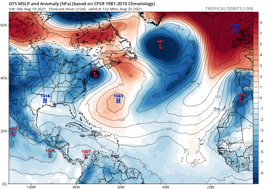
ICON has shown a New England hit in a couple of runs the last few days along with a few of the members of the Euro and GFS ensembles. New England and the Canadian coastline should keep a close eye on Henri.
0 likes
-
Keldeo1997
- Category 2

- Posts: 688
- Joined: Fri Oct 11, 2019 11:35 pm
Re: ATL: HENRI - Models
It doesn't help that GFS likes to underestimate ridge so NYC might need to watch out here
0 likes

Re: ATL: HENRI - Models
I know it's just one ensemble but on that 00Z GEFS the one going into NYC Harbor, I couldn't even imagine, Got a lot of family on LI keeping an close watch on this. Even with a majority showing an OTS eventually.
0 likes
Once I see the REDS and GREENS Converge on a Base Velocity. ... I'm There!!
This is NOT an Official Forecast....Just my Opinion. For official information, please refer to the NHC and NWS products.
HIGHLIGHTS : '13 El Reno Tornado : 2013 Storm Chaser Tour, Joaquin; SC flood event, Matthew '16, Lowcountry Snow storm Jan '18
This is NOT an Official Forecast....Just my Opinion. For official information, please refer to the NHC and NWS products.
HIGHLIGHTS : '13 El Reno Tornado : 2013 Storm Chaser Tour, Joaquin; SC flood event, Matthew '16, Lowcountry Snow storm Jan '18
-
TheDreamTraveler

- Category 2
- Posts: 645
- Joined: Sun Aug 22, 2010 3:10 am
- Location: PA
Re: ATL: HENRI - Models
6z gfs is another hit on new england. has it stronger before approach in the 960's but landfalls around 982mb still
Last edited by TheDreamTraveler on Wed Aug 18, 2021 5:14 am, edited 1 time in total.
0 likes

Re: ATL: HENRI - Models
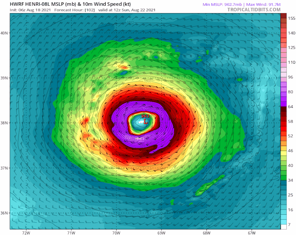
06z GFS shows a Cat 3 hurricane while recurving, and the 00z HWRF shows a Cat 4 at around the same time and place. The possibility of this hitting New England means there’s a non-zero chance Henri becomes the first major hurricane to threaten the region since Bob.
Good thing I got a portable generator and had a bunch of trees cut down last summer.
Good thing I got a portable generator and had a bunch of trees cut down last summer.
1 likes
Irene '11 Sandy '12 Hermine '16 5/15/2018 Derecho Fay '20 Isaias '20 Elsa '21 Henri '21 Ida '21
I am only a meteorology enthusiast who knows a decent amount about tropical cyclones. Look to the professional mets, the NHC, or your local weather office for the best information.
I am only a meteorology enthusiast who knows a decent amount about tropical cyclones. Look to the professional mets, the NHC, or your local weather office for the best information.
-
TheDreamTraveler
- Category 2
- Posts: 645
- Joined: Sun Aug 22, 2010 3:10 am
- Location: PA
Re: ATL: HENRI - Models
aspen wrote:06z GFS shows a Cat 3 hurricane while recurving, and the 00z HWRF shows a Cat 4 at around the same time and place. The possibility of this hitting New England means there’s a non-zero chance Henri becomes the first major hurricane to threaten the region since Bob.
Good thing I got a portable generator and had a bunch of trees cut down last summer.
Not sure if you just mean a hurricane but there hasn't been any major cat 3+ hurricanes in new england since the 1960s. But yeah last actual hurricane was bob in 1991
1 likes
Re: ATL: HENRI - Models
I am not liking the 06Z GFS for NE's sake, One this run deepens it more to 964/965MB(high end Cat 2) paralleling the East coast. Also I noticed it dives it more south before the N turn. 
0 likes
Once I see the REDS and GREENS Converge on a Base Velocity. ... I'm There!!
This is NOT an Official Forecast....Just my Opinion. For official information, please refer to the NHC and NWS products.
HIGHLIGHTS : '13 El Reno Tornado : 2013 Storm Chaser Tour, Joaquin; SC flood event, Matthew '16, Lowcountry Snow storm Jan '18
This is NOT an Official Forecast....Just my Opinion. For official information, please refer to the NHC and NWS products.
HIGHLIGHTS : '13 El Reno Tornado : 2013 Storm Chaser Tour, Joaquin; SC flood event, Matthew '16, Lowcountry Snow storm Jan '18
-
AlphaToOmega
- Category 5

- Posts: 1448
- Joined: Sat Jun 26, 2021 10:51 am
- Location: Somewhere in Massachusetts
-
TheDreamTraveler
- Category 2
- Posts: 645
- Joined: Sun Aug 22, 2010 3:10 am
- Location: PA
Re: ATL: HENRI - Models
Kohlecane wrote:I am not liking the 06Z GFS for NE's sake, One this run deepens it more to 964/965MB(high end Cat 2) paralleling the East coast. Also I noticed it dives it more south before the N turn.
Yeah I noticed that too. The runs just keep going farther west. The stronger it gets the farther west it gets
0 likes

Re: ATL: HENRI - Models
Woke up to see the 06z GFS and I live only a few miles from Narragansett Bay so I’m definitely keeping an eye on future model runs.
I live only a few miles from Narragansett Bay so I’m definitely keeping an eye on future model runs.
0 likes
-
Iceresistance

- Category 5
- Posts: 9598
- Age: 22
- Joined: Sat Oct 10, 2020 9:45 am
- Location: Tecumseh, OK/Norman, OK
Re: ATL: HENRI - Models
The 6z GFS is making me worried for the East Coast now . . .
Even if it does miss, it's getting closer to there . . .

Even if it does miss, it's getting closer to there . . .
0 likes
Bill 2015 & Beta 2020
Winter 2020-2021
All observations are in Tecumseh, OK unless otherwise noted.
Winter posts are focused mainly for Oklahoma & Texas.
Take any of my forecasts with a grain of salt, refer to the NWS, SPC, and NHC for official information
Never say Never with weather! Because ANYTHING is possible!
Winter 2020-2021
All observations are in Tecumseh, OK unless otherwise noted.
Winter posts are focused mainly for Oklahoma & Texas.
Take any of my forecasts with a grain of salt, refer to the NWS, SPC, and NHC for official information
Never say Never with weather! Because ANYTHING is possible!
Re: ATL: HENRI - Models
Iceresistance wrote:The 6z GFS is making me worried for the East Coast now . . .
Even if it does miss, it's getting closer to there . . .
https://s5.gifyu.com/images/gfs_mslp_pcpn_frzn_us_fh6-162.gif
I'm just trying to figure out the dynamics at play from Hr 90-108 that cause it to take a jog NW the N before moving out. You can see the steering that grabs it and brings it NE along the E Coast, it's just between that time frame I put that it takes a very noticeable Leap NW almost like it wants to make sure I stop by LI,NY to grab a slice of pizza first!
0 likes
Once I see the REDS and GREENS Converge on a Base Velocity. ... I'm There!!
This is NOT an Official Forecast....Just my Opinion. For official information, please refer to the NHC and NWS products.
HIGHLIGHTS : '13 El Reno Tornado : 2013 Storm Chaser Tour, Joaquin; SC flood event, Matthew '16, Lowcountry Snow storm Jan '18
This is NOT an Official Forecast....Just my Opinion. For official information, please refer to the NHC and NWS products.
HIGHLIGHTS : '13 El Reno Tornado : 2013 Storm Chaser Tour, Joaquin; SC flood event, Matthew '16, Lowcountry Snow storm Jan '18
Re: ATL: HENRI - Models
Kohlecane wrote:Iceresistance wrote:The 6z GFS is making me worried for the East Coast now . . .
Even if it does miss, it's getting closer to there . . .
https://s5.gifyu.com/images/gfs_mslp_pcpn_frzn_us_fh6-162.gif
I'm just trying to figure out the dynamics at play from Hr 90-108 that cause it to take a jog NW the N before moving out. You can see the steering that grabs it and brings it NE along the E Coast, it's just between that time frame I put that it takes a very noticeable Leap NW almost like it wants to make sure I stop by LI,NY to grab a slice of pizza first!
I read that the uncertainty is in how deep the trough is in the eastern USA with a strengthening ridge downstream from Henri. So plenty of uncertainty but bears watching
Last edited by pgoss11 on Wed Aug 18, 2021 6:15 am, edited 1 time in total.
0 likes
Re: ATL: HENRI - Models
HMON pushing the limits on 74W with each run
0 likes
Once I see the REDS and GREENS Converge on a Base Velocity. ... I'm There!!
This is NOT an Official Forecast....Just my Opinion. For official information, please refer to the NHC and NWS products.
HIGHLIGHTS : '13 El Reno Tornado : 2013 Storm Chaser Tour, Joaquin; SC flood event, Matthew '16, Lowcountry Snow storm Jan '18
This is NOT an Official Forecast....Just my Opinion. For official information, please refer to the NHC and NWS products.
HIGHLIGHTS : '13 El Reno Tornado : 2013 Storm Chaser Tour, Joaquin; SC flood event, Matthew '16, Lowcountry Snow storm Jan '18
Re: ATL: HENRI - Models
Im a very optimistic person, but HMON has been very persistent and one of the first few models showing this NE strike. But if what I just saw on the 6Z were to come to fruition that angle of approach to the NW as a decent Cat 1 with full moon in 5 days ->tides plus storm surge.. I don't wanna throw it out there but it would make Sandy look like a bad noreaster IMO
0 likes
Once I see the REDS and GREENS Converge on a Base Velocity. ... I'm There!!
This is NOT an Official Forecast....Just my Opinion. For official information, please refer to the NHC and NWS products.
HIGHLIGHTS : '13 El Reno Tornado : 2013 Storm Chaser Tour, Joaquin; SC flood event, Matthew '16, Lowcountry Snow storm Jan '18
This is NOT an Official Forecast....Just my Opinion. For official information, please refer to the NHC and NWS products.
HIGHLIGHTS : '13 El Reno Tornado : 2013 Storm Chaser Tour, Joaquin; SC flood event, Matthew '16, Lowcountry Snow storm Jan '18
Re: ATL: HENRI - Models
Even the HWRF shifting more W than the 0Z, will be interesting to see what the 12Z and later runs show today as we are within a potential 5 day window. Also will recon make a mission now that this has more guidance of potential impact?
0 likes
Once I see the REDS and GREENS Converge on a Base Velocity. ... I'm There!!
This is NOT an Official Forecast....Just my Opinion. For official information, please refer to the NHC and NWS products.
HIGHLIGHTS : '13 El Reno Tornado : 2013 Storm Chaser Tour, Joaquin; SC flood event, Matthew '16, Lowcountry Snow storm Jan '18
This is NOT an Official Forecast....Just my Opinion. For official information, please refer to the NHC and NWS products.
HIGHLIGHTS : '13 El Reno Tornado : 2013 Storm Chaser Tour, Joaquin; SC flood event, Matthew '16, Lowcountry Snow storm Jan '18
-
TheDreamTraveler
- Category 2
- Posts: 645
- Joined: Sun Aug 22, 2010 3:10 am
- Location: PA
Re: ATL: HENRI - Models
Kohlecane wrote:Even the HWRF shifting more W than the 0Z, will be interesting to see what the 12Z and later runs show today as we are within a potential 5 day window. Also will recon make a mission now that this has more guidance of potential impact?
HWRF is showing it getting really strong too..
https://twitter.com/MJVentrice/status/1427966347376570374
0 likes
-
TheDreamTraveler
- Category 2
- Posts: 645
- Joined: Sun Aug 22, 2010 3:10 am
- Location: PA
Re: ATL: HENRI - Models
Here's another good example of the last time a hurricane hit new england...this site didn't even exist for another 10 years or so since the last time one did lol
0 likes


Who is online
Users browsing this forum: No registered users and 12 guests