ATL: NICOLE - Models
Moderator: S2k Moderators

Re: ATL: NICOLE - Models
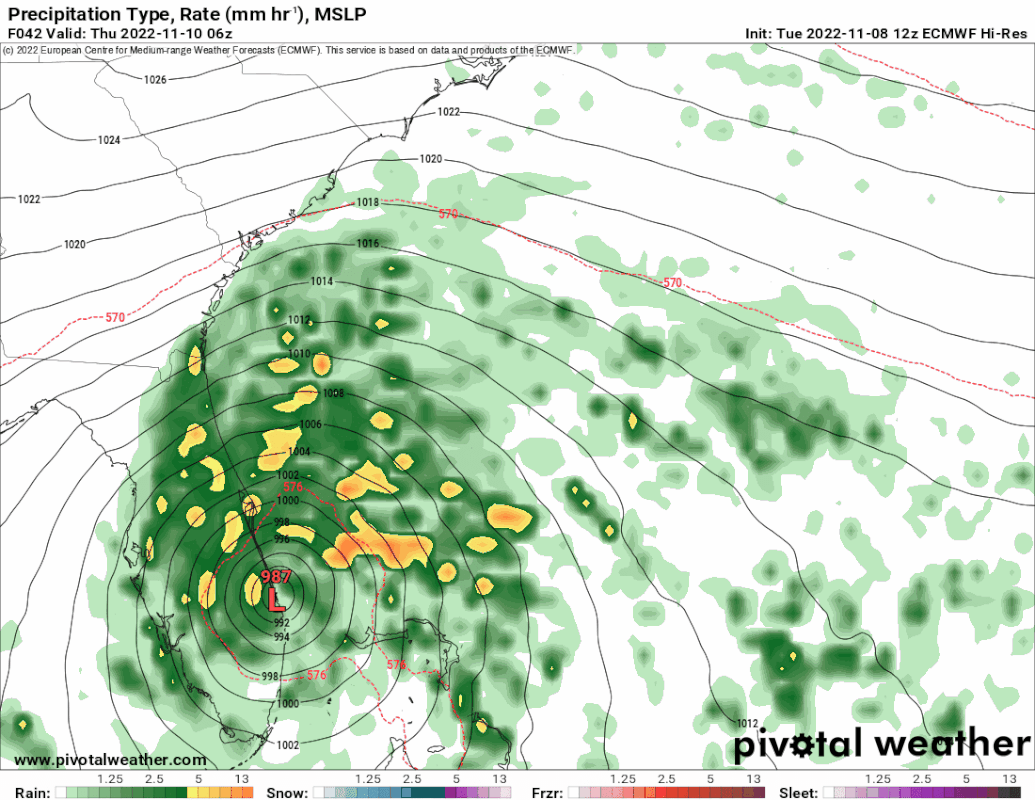
Anybody have the new 12z model from for the HAFS v0.3S? It's stuck on hour 3 over at Tropical Tidbits.
0 likes
-
DESTRUCTION5

- Category 5

- Posts: 4430
- Age: 44
- Joined: Wed Sep 03, 2003 11:25 am
- Location: Stuart, FL
Re: ATL: NICOLE - Models
12z Euro landfall in less than 40 hrs in Port st Lucie area. Stronger.
0 likes
GATOR NATION IS E V E R Y W H E R E !

Re: RE: Re: ATL: NICOLE - Models
jlauderdal wrote:Its one model run in a very unstable modeling environment, will have to see a solid trend which we dont have. We had south and west trend yesterday which evaporated today and of course has increased anxiety, even at NHC.MetroMike wrote:Interesting to note the 12z GFS keeps it a hurricane across the state, something my local station are not publically saying. How can this track stay so south when official track stays North?
The ridge capture looks like it completed a little earlier than models anticipated and the official track may have to lag a little as they bring that south again. If recon finds a stronger storm that could mess with the models as well.
2 likes
-
tolakram
- Admin

- Posts: 20186
- Age: 62
- Joined: Sun Aug 27, 2006 8:23 pm
- Location: Florence, KY (name is Mark)
Re: ATL: NICOLE - Models

0 likes
M a r k
- - - - -
Join us in chat: Storm2K Chatroom Invite. Android and IOS apps also available.
The posts in this forum are NOT official forecasts and should not be used as such. Posts are NOT endorsed by any professional institution or STORM2K.org. For official information and forecasts, please refer to NHC and NWS products.
Re: ATL: NICOLE - Models
DESTRUCTION5 wrote:12z Euro landfall in less than 40 hrs in Port st Lucie area. Stronger.
Since the 6Z Euro was near Ft. Pierce, the 12Z Euro is based on your info ~15 miles south of the 6Z. This means that all of the major dynamic models are south of their respective 6Z runs at FL landfall. But the HWRF was a little north at 12Z.
1 likes
Personal Forecast Disclaimer:
The posts in this forum are NOT official forecasts and should not be used as such. They are just the opinion of the poster and may or may not be backed by sound meteorological data. They are NOT endorsed by any professional institution or storm2k.org. For official information, please refer to the NHC and NWS products.
The posts in this forum are NOT official forecasts and should not be used as such. They are just the opinion of the poster and may or may not be backed by sound meteorological data. They are NOT endorsed by any professional institution or storm2k.org. For official information, please refer to the NHC and NWS products.

-
Blown Away

- S2K Supporter

- Posts: 10253
- Joined: Wed May 26, 2004 6:17 am
Re: ATL: NICOLE - Models
DESTRUCTION5 wrote:12z Euro landfall in less than 40 hrs in Port st Lucie area. Stronger.
This is just a thing between us MC residents, but I have Sewall's Point for EURO based on latitude. I know it's insignificant.
1 likes
Hurricane Eye Experience: David 79, Irene 99, Frances 04, Jeanne 04, Wilma 05… Hurricane Brush Experience: Andrew 92, Erin 95, Floyd 99, Matthew 16, Irma 17, Ian 22, Nicole 22…
-
Coolcruiseman
- Tropical Depression

- Posts: 97
- Age: 52
- Joined: Wed Sep 21, 2022 8:10 pm
- Location: Melbourne, FL
Re: ATL: NICOLE - Models
From the 1 pm update:
"A west-southwest motion is expected through early Wednesday. A west-northwest motion is forecast to begin on Wednesday night, followed by a turn toward the northwest and north-northwest on Thursday and Thursday night."
Was this expected and taken into account by the models?
"A west-southwest motion is expected through early Wednesday. A west-northwest motion is forecast to begin on Wednesday night, followed by a turn toward the northwest and north-northwest on Thursday and Thursday night."
Was this expected and taken into account by the models?
1 likes
-
tolakram
- Admin
- Posts: 20186
- Age: 62
- Joined: Sun Aug 27, 2006 8:23 pm
- Location: Florence, KY (name is Mark)
Re: ATL: NICOLE - Models

0 likes
M a r k
- - - - -
Join us in chat: Storm2K Chatroom Invite. Android and IOS apps also available.
The posts in this forum are NOT official forecasts and should not be used as such. Posts are NOT endorsed by any professional institution or STORM2K.org. For official information and forecasts, please refer to NHC and NWS products.
- - - - -
Join us in chat: Storm2K Chatroom Invite. Android and IOS apps also available.
The posts in this forum are NOT official forecasts and should not be used as such. Posts are NOT endorsed by any professional institution or STORM2K.org. For official information and forecasts, please refer to NHC and NWS products.
-
DESTRUCTION5
- Category 5
- Posts: 4430
- Age: 44
- Joined: Wed Sep 03, 2003 11:25 am
- Location: Stuart, FL
Re: ATL: NICOLE - Models
Blown Away wrote:DESTRUCTION5 wrote:12z Euro landfall in less than 40 hrs in Port st Lucie area. Stronger.
This is just a thing between us MC residents, but I have Sewall's Point for EURO based on latitude. I know it's insignificant.
1 likes
GATOR NATION IS E V E R Y W H E R E !
-
Blown Away
- S2K Supporter
- Posts: 10253
- Joined: Wed May 26, 2004 6:17 am
Re: ATL: NICOLE - Models
I’m not a GFS hugger, but 12z is in Palm Beach County… Being @36 hours out I’m stunned how off the model is from the NHC track.
2 likes
Hurricane Eye Experience: David 79, Irene 99, Frances 04, Jeanne 04, Wilma 05… Hurricane Brush Experience: Andrew 92, Erin 95, Floyd 99, Matthew 16, Irma 17, Ian 22, Nicole 22…

Re: ATL: NICOLE - Models
cane5 wrote:Jr0d wrote:chaser1 wrote:As for northward track adjustments, sure.... the 500mb orientation would suggest a deep tropical cyclone should respond with a distinct West to WSW motion given the location and strength of the mid level bubble ridge over the Tennessee valley. What I believe may be occurring is a far more "smoothed" out west and sooner WNW track as a result of primary steering being controlled by lower level ridging centered over and east of the US seaboard. It feels like watching a shallow tropical system move along with what was the old "Shallow BAM" models.
The models were not showing the WSW to SW dive until later tonight through most of Wednesday.
These WSW dives are tough to forecast but most certainly will happen with Nichole. I think this is the biggest question mark on the ultimate track. We have seen countless storms make the south dive with no forecast, so my opinion is it may dive further south than the models are indicating.
Also the models are in good agreement that Nichole will
transition to fully tropical while taking the south dive. This will enable Nichole to become a hurricane.
The models now show a weaker high pressure ridge which is why the track has moved a bit north pretty logical stuff. ICON nailed it again. And being in Miami I am breathing easier today.
ICON
3 likes
Andy D
(For official information, please refer to the NHC and NWS products.)
(For official information, please refer to the NHC and NWS products.)
-
AxaltaRacing24
- Category 5
- Posts: 1774
- Age: 25
- Joined: Wed Jul 27, 2016 11:14 am
- Location: Jupiter, FL
Re: ATL: NICOLE - Models
chaser1 wrote:cane5 wrote:Jr0d wrote:
The models were not showing the WSW to SW dive until later tonight through most of Wednesday.
These WSW dives are tough to forecast but most certainly will happen with Nichole. I think this is the biggest question mark on the ultimate track. We have seen countless storms make the south dive with no forecast, so my opinion is it may dive further south than the models are indicating.
Also the models are in good agreement that Nichole will
transition to fully tropical while taking the south dive. This will enable Nichole to become a hurricane.
The models now show a weaker high pressure ridge which is why the track has moved a bit north pretty logical stuff. ICON nailed it again. And being in Miami I am breathing easier today.
ICON(Blind squirel - nut)
The ICON also just took a pretty decent shift south at 12z after "nailing it" too.
3 likes
-
jlauderdal
- S2K Supporter
- Posts: 7240
- Joined: Wed May 19, 2004 5:46 am
- Location: NE Fort Lauderdale
- Contact:
Re: ATL: NICOLE - Models
Blown Away wrote:I’m not a GFS hugger, but 12z is in Palm Beach County… Being @36 hours out I’m stunned how off the model is from the NHC track.
So is the NHC as alluded to in the last discussion...GFS has been good for this system so it has to be taken seriously.
2 likes
-
hurricane2025
- Category 1

- Posts: 254
- Joined: Thu Apr 08, 2021 10:36 am
-
AutoPenalti
- Category 5
- Posts: 4091
- Age: 29
- Joined: Mon Aug 17, 2015 4:16 pm
- Location: Ft. Lauderdale, Florida
Re: ATL: NICOLE - Models
hurricane2025 wrote:Could see a cat 3
A cat 3 would be unprecedented. I don't think it will intensify that much.
2 likes
The posts in this forum are NOT official forecasts and should not be used as such. They are just the opinion of the poster and may or may not be backed by sound meteorological data. They are NOT endorsed by any professional institution or STORM2K. For official information, please refer to products from the NHC and NWS.
Model Runs Cheat Sheet:
GFS (5:30 AM/PM, 11:30 AM/PM)
HWRF, GFDL, UKMET, NAVGEM (6:30-8:00 AM/PM, 12:30-2:00 AM/PM)
ECMWF (1:45 AM/PM)
TCVN is a weighted averaged
-
Poonwalker
- Category 1
- Posts: 270
- Joined: Tue Sep 20, 2022 11:12 am
Re: ATL: NICOLE - Models
Blown Away wrote:I’m not a GFS hugger, but 12z is in Palm Beach County… Being @36 hours out I’m stunned how off the model is from the NHC track.
Iam with you on that one. GFS has handled this storm accurately so far, I would be surprised we don't see them update the track to the left with another run supporting that response.
1 likes
-
hurricane2025
- Category 1
- Posts: 254
- Joined: Thu Apr 08, 2021 10:36 am
Re: ATL: NICOLE - Models
[Tweet][/Tweet]
Hwrf and haf show cat 3
AutoPenalti wrote:hurricane2025 wrote:Could see a cat 3
A cat 3 would be unprecedented. I don't think it will intensify that much.
Hwrf and haf show cat 3
0 likes
-
Blown Away
- S2K Supporter
- Posts: 10253
- Joined: Wed May 26, 2004 6:17 am
Re: ATL: NICOLE - Models
jlauderdal wrote:Blown Away wrote:I’m not a GFS hugger, but 12z is in Palm Beach County… Being @36 hours out I’m stunned how off the model is from the NHC track.
So is the NHC as alluded to in the last discussion...GFS has been good for this system so it has to be taken seriously.
How does, if any, would a stronger deeper hurricane moving WSW respond to a very strong HP?? Past examples they go farther S? Does this apply here?
2 likes
Hurricane Eye Experience: David 79, Irene 99, Frances 04, Jeanne 04, Wilma 05… Hurricane Brush Experience: Andrew 92, Erin 95, Floyd 99, Matthew 16, Irma 17, Ian 22, Nicole 22…
-
tolakram
- Admin
- Posts: 20186
- Age: 62
- Joined: Sun Aug 27, 2006 8:23 pm
- Location: Florence, KY (name is Mark)
Re: ATL: NICOLE - Models
hurricane2025 wrote:[url][/url]AutoPenalti wrote:hurricane2025 wrote:Could see a cat 3
A cat 3 would be unprecedented. I don't think it will intensify that much.
Hwrf and haf show cat 3
HWRF max winds are just cat 1 for the latest run, reducing prior to landfall.

2 likes
M a r k
- - - - -
Join us in chat: Storm2K Chatroom Invite. Android and IOS apps also available.
The posts in this forum are NOT official forecasts and should not be used as such. Posts are NOT endorsed by any professional institution or STORM2K.org. For official information and forecasts, please refer to NHC and NWS products.
- - - - -
Join us in chat: Storm2K Chatroom Invite. Android and IOS apps also available.
The posts in this forum are NOT official forecasts and should not be used as such. Posts are NOT endorsed by any professional institution or STORM2K.org. For official information and forecasts, please refer to NHC and NWS products.
Who is online
Users browsing this forum: No registered users and 47 guests