ATL: INVEST 95L - Models

Moderator: S2k Moderators

Message
Author
User avatar
Teban54
Category 5
Category 5
Posts: 1980
Joined: Sat May 19, 2018 1:19 pm

Re: ATL: INVEST 95L - Models

#21 Postby Teban54 » Fri Jul 21, 2023 2:20 am

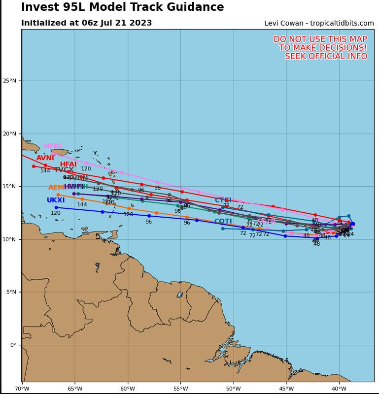
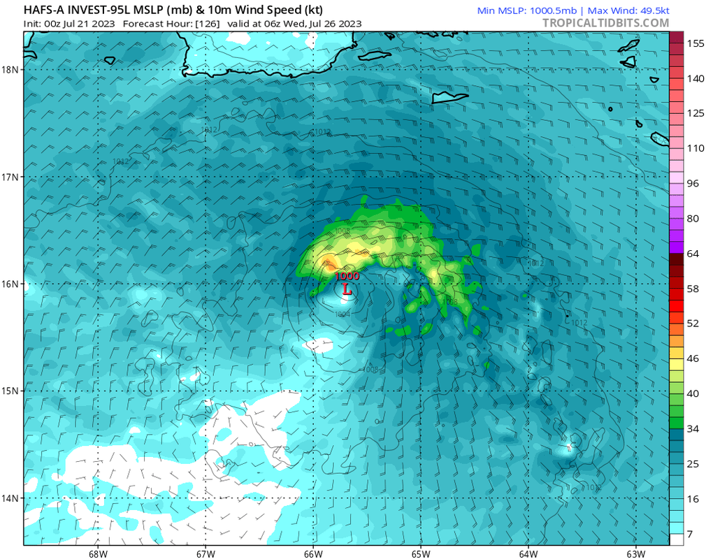
First HAFS runs are not as crazy as the operational GFS. HAFS-A appears to keep it as a minimal TD/TS (if at all) until it gets to the Lesser Antilles, after which it strengthens slightly in the NE Caribbean:
Image

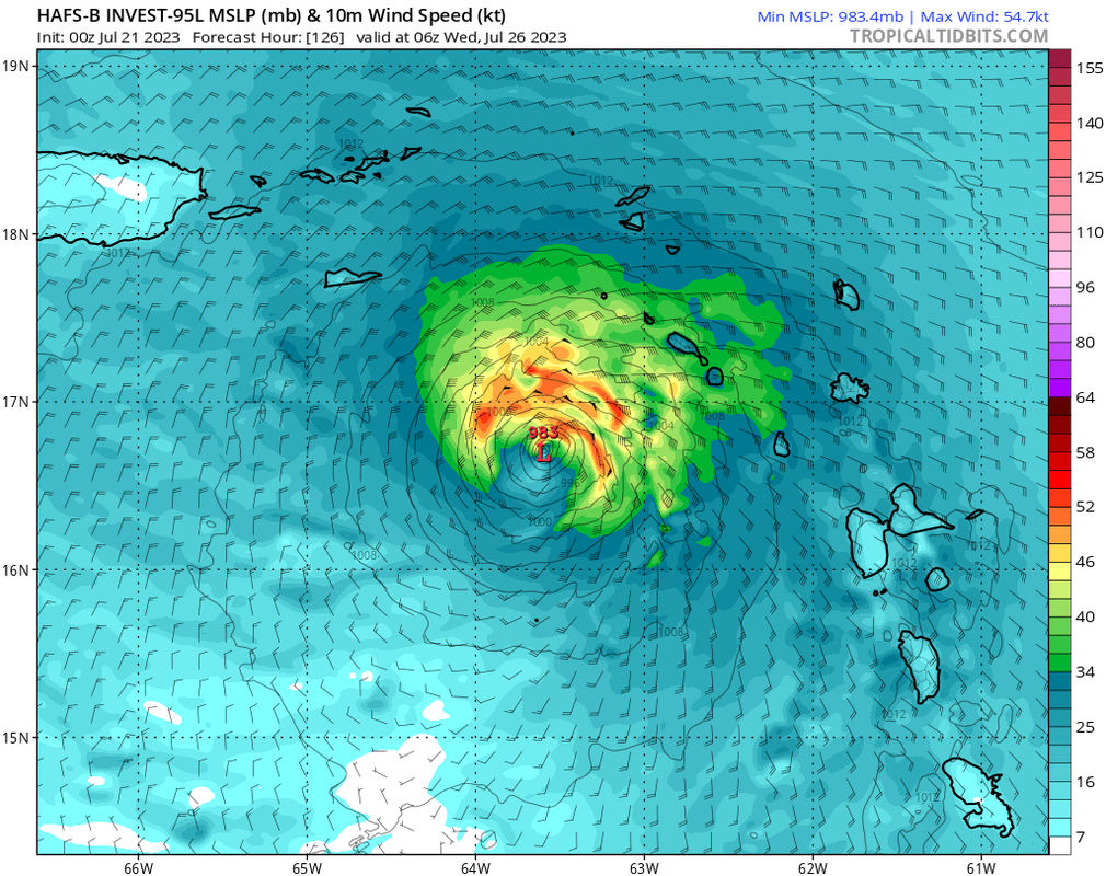
HAFS-B is stronger overall, with a strong TS approaching the Lesser Antilles and ending the run almost as a hurricane:
Image

Both HWRF and HMON are even stronger than HAFS-B, with a Cat 1 before the islands.
1 likes   

User avatar
Teban54
Category 5
Category 5
Posts: 1980
Joined: Sat May 19, 2018 1:19 pm

Re: ATL: INVEST 95L - Models

#22 Postby Teban54 » Fri Jul 21, 2023 2:49 am

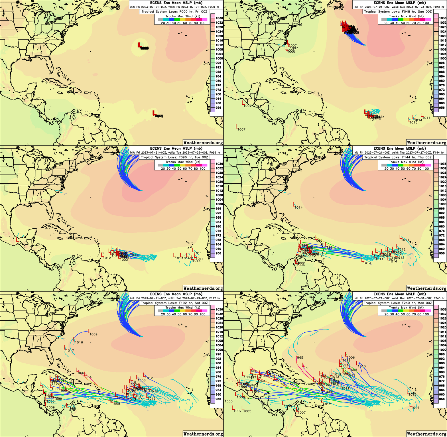
0z EPS support is also growing for both 95L and the trailing wave.
Image
0 likes   

User avatar
Blown Away
S2K Supporter
S2K Supporter
Posts: 9870
Joined: Wed May 26, 2004 6:17 am

Re: ATL: INVEST 95L - Models

#23 Postby Blown Away » Fri Jul 21, 2023 6:15 am

Image
Image

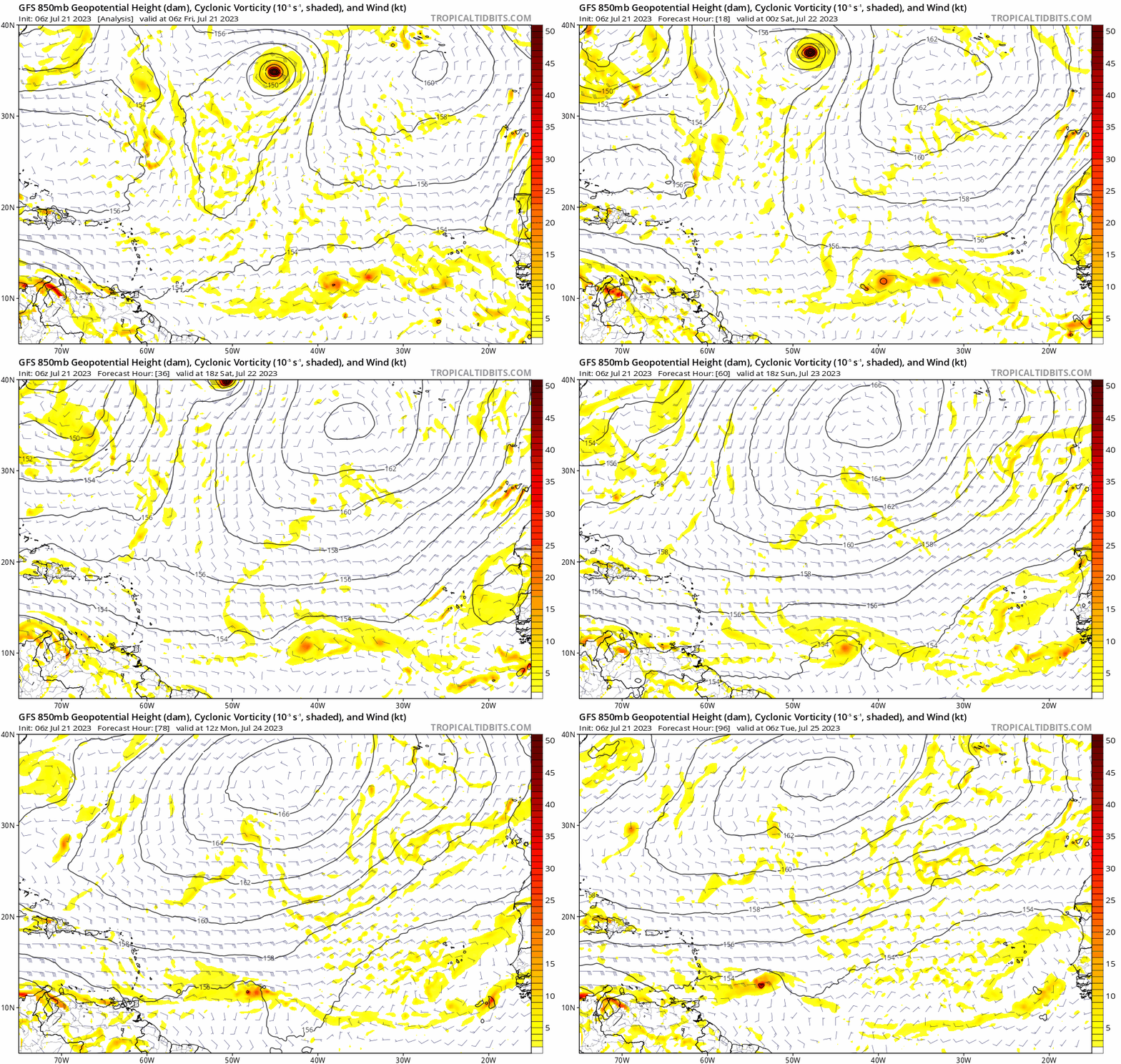
06z GFS... Some models continue showing this SW dip over next 2-3 days. IMO this SW dip is a critical move that will heavily influence development down the road. The SW dip will likely keep 95L weaker into the Caribbean and S of the big islands, if this dip doesn't happen I think the northern route possibly into better UL conditions may happen?
4 likes   
Hurricane Eye Experience: David 79, Irene 99, Frances 04, Jeanne 04, Wilma 05... EYE COMING MY WAY IN 2024…
Hurricane Brush Experience: Andrew 92, Erin 95, Floyd 99, Matthew 16, Irma 17, Ian 22, Nicole 22…

User avatar
abajan
S2K Supporter
S2K Supporter
Posts: 4175
Joined: Sun Sep 07, 2003 5:10 am
Location: Barbados

Re: ATL: INVEST 95L - Models

#24 Postby abajan » Fri Jul 21, 2023 7:28 am

Blown Away wrote:[url]https://i.postimg.cc/4Nk7sRhR/c3ea8cde-8077-4f7c-b562-117ac004684c.gif [/url]

06z GFS... Some models continue showing this SW dip over next 2-3 days. IMO this SW dip is a critical move that will heavily influence development down the road. The SW dip will likely keep 95L weaker into the Caribbean and S of the big islands, if this dip doesn't happen I think the northern route possibly into better UL conditions may happen?


That's a pretty pronounced dip. The Euro, and CMC (to a lesser extent), shows it too. Can't recall when last I've seen models show anything like that in the MDR east of the Antilles.
1 likes   

User avatar
Category5Kaiju
Category 5
Category 5
Posts: 3418
Age: 22
Joined: Thu Dec 24, 2020 12:45 pm
Location: Seattle

Re: ATL: INVEST 95L - Models

#25 Postby Category5Kaiju » Fri Jul 21, 2023 7:36 am

abajan wrote:
Blown Away wrote:[url]https://i.postimg.cc/4Nk7sRhR/c3ea8cde-8077-4f7c-b562-117ac004684c.gif [/url]

06z GFS... Some models continue showing this SW dip over next 2-3 days. IMO this SW dip is a critical move that will heavily influence development down the road. The SW dip will likely keep 95L weaker into the Caribbean and S of the big islands, if this dip doesn't happen I think the northern route possibly into better UL conditions may happen?


That's a pretty pronounced dip. The Euro, and CMC (to a lesser extent), shows it too. Can't recall when last I've seen models show anything like that in the MDR east of the Antilles.


I think Elsa (2021), very slightly, featured this kind of dip. Irma did too
1 likes   
Unless explicitly stated, all information covered in my posts is based on my opinions and observations. Please refer to a professional meteorologist or an accredited weather research agency otherwise, especially if serious decisions must be made in the event of a potentially life-threatening tropical storm or hurricane.

User avatar
SFLcane
S2K Supporter
S2K Supporter
Posts: 9621
Age: 46
Joined: Sat Jun 05, 2010 1:44 pm
Location: Lake Worth Florida

Re: ATL: INVEST 95L - Models

#26 Postby SFLcane » Fri Jul 21, 2023 8:36 am

:eek:

Image
0 likes   

LarryWx
Category 5
Category 5
Posts: 5754
Joined: Sun Sep 07, 2003 2:04 pm
Location: GA

ATL: INVEST 95L - Discussion

#27 Postby LarryWx » Fri Jul 21, 2023 9:44 am

The 6Z EPS has 7 of its 51 get this into the Caribbean at sub 1000 mb/TS+. Two of the members get down to sub 985/H near Greater Antilles.
0 likes   
Personal Forecast Disclaimer:
The posts in this forum are NOT official forecasts and should not be used as such. They are just the opinion of the poster and may or may not be backed by sound meteorological data. They are NOT endorsed by any professional institution or storm2k.org. For official information, please refer to the NHC and NWS products.

User avatar
Spacecoast
Category 2
Category 2
Posts: 687
Joined: Thu Aug 31, 2017 2:03 pm

Re: ATL: INVEST 95L - Models

#28 Postby Spacecoast » Fri Jul 21, 2023 9:46 am

FWIW...
0z EPS @168 hrs:
45-50% chance of TD.
Image
10-20% chance of TS.
Image

*note: on these charts, one or two members (<5%), are 'invisible'.
Last edited by Spacecoast on Fri Jul 21, 2023 9:50 am, edited 1 time in total.
0 likes   

User avatar
SFLcane
S2K Supporter
S2K Supporter
Posts: 9621
Age: 46
Joined: Sat Jun 05, 2010 1:44 pm
Location: Lake Worth Florida

Re: ATL: INVEST 95L - Models

#29 Postby SFLcane » Fri Jul 21, 2023 9:48 am

Image
0 likes   

User avatar
Blown Away
S2K Supporter
S2K Supporter
Posts: 9870
Joined: Wed May 26, 2004 6:17 am

Re: ATL: INVEST 95L - Discussion

#30 Postby Blown Away » Fri Jul 21, 2023 9:55 am

Image
Image

No signs of that SW dip. IMO that will allow for a track on the N side of the model envelope.
0 likes   
Hurricane Eye Experience: David 79, Irene 99, Frances 04, Jeanne 04, Wilma 05... EYE COMING MY WAY IN 2024…
Hurricane Brush Experience: Andrew 92, Erin 95, Floyd 99, Matthew 16, Irma 17, Ian 22, Nicole 22…

User avatar
abajan
S2K Supporter
S2K Supporter
Posts: 4175
Joined: Sun Sep 07, 2003 5:10 am
Location: Barbados

Re: ATL: INVEST 95L - Models

#31 Postby abajan » Fri Jul 21, 2023 9:56 am

OOPS! Apologies for posting this in the models thread. :oops:
If it's possible for a mod to move it, please do so.

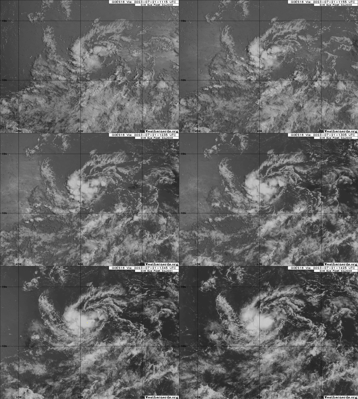
:eek: I think this loop speaks for itself. Suffice it to say that, should the current trend continue, we're likely looking at a TD or TS as soon as tonight.

Image
Last edited by abajan on Fri Jul 21, 2023 11:57 am, edited 1 time in total.
4 likes   

User avatar
REDHurricane
Tropical Storm
Tropical Storm
Posts: 207
Age: 26
Joined: Sun Jul 03, 2022 2:36 pm
Location: Northeast Pacific Ocean

Re: ATL: INVEST 95L - Discussion

#32 Postby REDHurricane » Fri Jul 21, 2023 10:03 am

All 6z models showing a nice pocket of moisture around 52-55W even with the significant dry air to the north:

GFS
Image

ECMWF
Image

HAFS-A
Image

HWRF
Image

The only reason I can maybe see as to why only the Euro doesn't develop 95L is that it predicts this system to move just a bit faster compared to the others, leaving some of the moist mid-level air behind and entering a slightly less favorable wind shear environment?

GFS
Image

ECMWF
Image

HAFS-A
Image

HWRF
Image

I'm inclined to think this will probably develop into at least a weak TS before it gets to the Caribbean like the GFS/HAFS-A/HWRF/other hurricane models are predicting. Really warm water = more tropical cyclones, right?
1 likes   

User avatar
Ivanhater
Storm2k Moderator
Storm2k Moderator
Posts: 10853
Age: 37
Joined: Fri Jul 01, 2005 8:25 am
Location: Pensacola

Re: ATL: INVEST 95L - Models

#33 Postby Ivanhater » Fri Jul 21, 2023 10:12 am

Curious to see if the 12z guidance latches on to the recent convective trend, at least in the short term.
0 likes   
Michael

User avatar
Spacecoast
Category 2
Category 2
Posts: 687
Joined: Thu Aug 31, 2017 2:03 pm

Re: ATL: INVEST 95L - Discussion

#34 Postby Spacecoast » Fri Jul 21, 2023 10:16 am

Hypercane_Kyle wrote:Small system, I think it's possible the global models may not be resolving it very well. .....

Not resolving (very well) at all.
Image
0 likes   

BobHarlem
Category 5
Category 5
Posts: 1666
Joined: Thu Oct 20, 2005 6:11 pm

Re: ATL: INVEST 95L - Models

#35 Postby BobHarlem » Fri Jul 21, 2023 10:25 am

12z Icon is showing that dip too for tomorrow afternoon and Sunday.
Image
Last edited by BobHarlem on Fri Jul 21, 2023 10:45 am, edited 1 time in total.
0 likes   

User avatar
Ivanhater
Storm2k Moderator
Storm2k Moderator
Posts: 10853
Age: 37
Joined: Fri Jul 01, 2005 8:25 am
Location: Pensacola

Re: ATL: INVEST 95L - Models

#36 Postby Ivanhater » Fri Jul 21, 2023 10:33 am

BobHarlem wrote:12z Icon is showing that dip too for tomorrow afternoon and Sunday.


Also coming in stronger so far with a strengthening TS coming into the Caribbean
0 likes   
Michael

User avatar
aspen
Category 5
Category 5
Posts: 8059
Joined: Sat Oct 12, 2019 7:10 pm
Location: Connecticut, USA

Re: ATL: INVEST 95L - Models

#37 Postby aspen » Fri Jul 21, 2023 11:19 am

Ivanhater wrote:Curious to see if the 12z guidance latches on to the recent convective trend, at least in the short term.

12z GFS still initializes very poorly and doesn’t develop.
0 likes   
Irene '11 Sandy '12 Hermine '16 5/15/2018 Derecho Fay '20 Isaias '20 Elsa '21 Henri '21 Ida '21

I am only a meteorology enthusiast who knows a decent amount about tropical cyclones. Look to the professional mets, the NHC, or your local weather office for the best information.

User avatar
cycloneye
Admin
Admin
Posts: 139498
Age: 67
Joined: Thu Oct 10, 2002 10:54 am
Location: San Juan, Puerto Rico

Re: ATL: INVEST 95L - Models

#38 Postby cycloneye » Fri Jul 21, 2023 1:08 pm

HAFS-A at 989 mbs south of PR.

Image

HAFS-B at 973 mbs south of Mona Channel.

Image
0 likes   
Visit the Caribbean-Central America Weather Thread where you can find at first post web cams,radars
and observations from Caribbean basin members Click Here

User avatar
SFLcane
S2K Supporter
S2K Supporter
Posts: 9621
Age: 46
Joined: Sat Jun 05, 2010 1:44 pm
Location: Lake Worth Florida

Re: ATL: INVEST 95L - Models

#39 Postby SFLcane » Fri Jul 21, 2023 1:16 pm

cycloneye wrote:HAFS-A at 989 mbs south of PR.

https://i.imgur.com/eb7QIKX.png

HAFS-B at 973 mbs south of Mona Channel.

https://i.imgur.com/IbdoN0v.png


Hurricane models really aren't best for invests...it's an interesting piece of info. Global models basically all kill it
2 likes   

User avatar
Nimbus
Category 5
Category 5
Posts: 4929
Joined: Mon Jul 19, 2004 10:54 am

Re: ATL: INVEST 95L - Models

#40 Postby Nimbus » Fri Jul 21, 2023 1:40 pm

Will likely need to be declared a TD fairly soon if that latest convective burst is the start of a trend.
About all we can say is its probably going to stay below hurricane strength and track west for now.
When the models track west of Jamaica we will know better if this is Pacific bound or gulf threat.
0 likes   


Return to “2023”

Who is online

Users browsing this forum: No registered users and 5 guests