ATL: BRET - Remnants - Discussion

Moderator: S2k Moderators

Message
Author
User avatar
Teban54
Category 5
Category 5
Posts: 3204
Joined: Sat May 19, 2018 1:19 pm

Re: ATL: THREE - Tropical Depression - Discussion

#221 Postby Teban54 » Mon Jun 19, 2023 1:00 pm

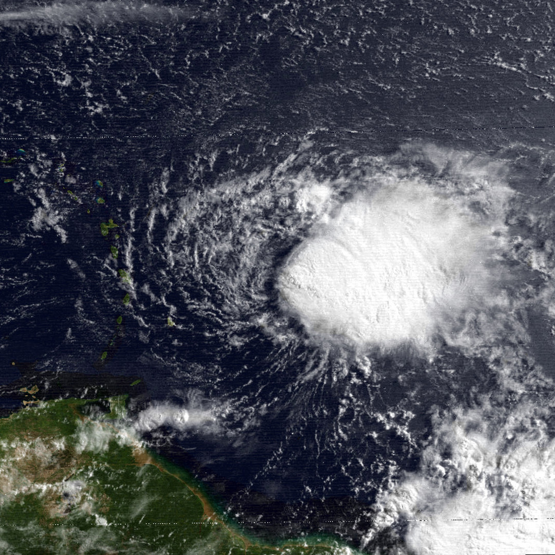
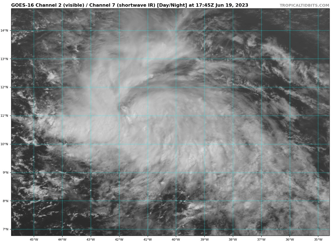
Comparing imagery of TD3 to other June MDR systems.

Obviously we don't have anything for Trinidad 1933, which peaked as a Cat 2 in Caribbean and Gulf. As for those in the satellite era:

Bret 2017 at its peak:
Image

Ana 1979 at its peak:
Image

TD3 2023 right now:
Image
9 likes   

User avatar
AnnularCane
S2K Supporter
S2K Supporter
Posts: 2862
Joined: Thu Jun 08, 2006 9:18 am
Location: Wytheville, VA

Re: ATL: THREE - Tropical Depression - Discussion

#222 Postby AnnularCane » Mon Jun 19, 2023 1:08 pm

Not your typical June TD. Or even TS. 8-)
6 likes   
"But it never rained rain. It never snowed snow. And it never blew just wind. It rained things like soup and juice. It snowed mashed potatoes and green peas. And sometimes the wind blew in storms of hamburgers." -- Judi Barrett, Cloudy with a Chance of Meatballs

GeauxTigers
Tropical Storm
Tropical Storm
Posts: 104
Joined: Sun Jan 14, 2018 5:35 pm
Location: Tioga, TX

Re: ATL: THREE - Tropical Depression - Discussion

#223 Postby GeauxTigers » Mon Jun 19, 2023 1:22 pm

wxman57 wrote:12Z GFS is finally coming around. Weakening TS enters the Caribbean then weakens to a depression or remnant low south of PR in about 5 days. Someone asked about Barbados - you won't see much out of it. A little rain and little wind south of the track. Wind will be about 20 mph less on the south side of the storm.


I’m flying to St John Wednesday. What can i expect out of this? Thank u!
0 likes   

User avatar
cycloneye
Admin
Admin
Posts: 145299
Age: 68
Joined: Thu Oct 10, 2002 10:54 am
Location: San Juan, Puerto Rico

Re: ATL: THREE - Tropical Depression - Discussion

#224 Postby cycloneye » Mon Jun 19, 2023 1:28 pm

Up to 2.5 on SSD Dvorak. Hello Bret.

A. 03L (NONAME)

B. 19/1730Z

C. 11.2N

D. 41.3W

E. THREE/GOES-E

F. T2.5/2.5

G. IR/EIR/VIS

H. REMARKS...5/10 BANDING RESULTS IN A DT OF 2.5. THE MET IS 1.5 AND
THE PT IS 2.0. THE FT IS BASED ON THE DT.

I. ADDL POSITIONS

NIL


...BROWN
5 likes   
Visit the Caribbean-Central America Weather Thread where you can find at first post web cams,radars
and observations from Caribbean basin members Click Here

User avatar
NDG
S2K Supporter
S2K Supporter
Posts: 15446
Joined: Sun Jul 09, 2006 10:14 pm
Location: Orlando, FL

Re: ATL: THREE - Tropical Depression - Discussion

#225 Postby NDG » Mon Jun 19, 2023 1:42 pm

ThomasW wrote:
Hypercane_Kyle wrote:
ThomasW wrote:Three likely ends up in the islands as a minimal tropical storm. NHC forecast is overblown, imo. GFS downtrended significantly at 12z and shear only looks to rise with a 21 mph forward motion. EL NINO.


Fast trades and shear in June are not exactly uncommon.

Not to mention you have two developing systems in the MDR, which is the exact opposite of what one would expect in June.

ThomasW wrote:My friend - I am just remindoing everyone that this is an El Nino. It isn't directly affecting Three as the atmosphere isn't coupled - yet :wink:


I'd recommend checking out the seasonal indicators thread on this. Right now Atlantic temperatures are the warmest ever recorded. That, combined with anomalously low SAL, is why we are seeing this insane surge of activity. This is not normal for June, no matter how you look at it.

I do understand the +AMO is incredibly strong as of now. But El nIno will win over warm surface temperatures in the Atlantic. You don't have to believe me, just wait until September rolls around and the Atlantic is SAL/shear stricken


Climate models, which so far are coming to fruition, don't agree with you.
1 likes   

User avatar
NDG
S2K Supporter
S2K Supporter
Posts: 15446
Joined: Sun Jul 09, 2006 10:14 pm
Location: Orlando, FL

Re: ATL: THREE - Tropical Depression - Discussion

#226 Postby NDG » Mon Jun 19, 2023 1:51 pm

Definitely looking like a Tropical Storm already with an improving outflow towards the south.

Last edited by NDG on Mon Jun 19, 2023 1:53 pm, edited 1 time in total.
5 likes   

User avatar
tiger_deF
Category 1
Category 1
Posts: 468
Age: 24
Joined: Tue Sep 27, 2016 11:47 am

Re: ATL: THREE - Tropical Depression - Discussion

#227 Postby tiger_deF » Mon Jun 19, 2023 1:52 pm

The geographic proximity of 3L and 93L is fascinating to me. Can they both become named systems without interrupting the ventilation of one another?
3 likes   

User avatar
NDG
S2K Supporter
S2K Supporter
Posts: 15446
Joined: Sun Jul 09, 2006 10:14 pm
Location: Orlando, FL

Re: ATL: THREE - Tropical Depression - Discussion

#228 Postby NDG » Mon Jun 19, 2023 1:55 pm

tiger_deF wrote:The geographic proximity of 3L and 93L is fascinating to me. Can they both become named systems without interrupting the ventilation of one another?


According to models no problem, if anything a better environment left behind for 93L
1 likes   

User avatar
cycloneye
Admin
Admin
Posts: 145299
Age: 68
Joined: Thu Oct 10, 2002 10:54 am
Location: San Juan, Puerto Rico

Re: ATL: THREE - Tropical Depression - Discussion

#229 Postby cycloneye » Mon Jun 19, 2023 1:59 pm

Hello Bret.

AL, 03, 2023061918, , BEST, 0, 112N, 414W, 35, 1008, TS
12 likes   
Visit the Caribbean-Central America Weather Thread where you can find at first post web cams,radars
and observations from Caribbean basin members Click Here

User avatar
Hypercane_Kyle
Category 5
Category 5
Posts: 3352
Joined: Sat Mar 07, 2015 7:58 pm
Location: Cape Canaveral, FL

Re: ATL: THREE - Tropical Depression - Discussion

#230 Postby Hypercane_Kyle » Mon Jun 19, 2023 2:01 pm

Bret 2017's record falls to... Bret 2023!
3 likes   
My posts are my own personal opinion, defer to the National Hurricane Center (NHC) and other NOAA products for decision making during hurricane season.

User avatar
Teban54
Category 5
Category 5
Posts: 3204
Joined: Sat May 19, 2018 1:19 pm

Re: ATL: THREE - Tropical Depression - Discussion

#231 Postby Teban54 » Mon Jun 19, 2023 2:06 pm

Hypercane_Kyle wrote:Bret 2017's record falls to... Bret 2023!

According to Bret 2017's TCR, it became a TS (straight from a PTC) on June 19 at 1800z, exactly the same time as TD3 2023's upgrade. So now the record for June MDR storms at TS intensity is a tie between Bret 2017 and Bret 2023, with the latter being much further east.

I won't be surprised if Bret 2023's upgrade is revised to be earlier in its TCR, though. It has looked like a TS for several hours now.
11 likes   

CrazyC83
Professional-Met
Professional-Met
Posts: 34002
Joined: Tue Mar 07, 2006 11:57 pm
Location: Deep South, for the first time!

Re: ATL: THREE - Tropical Depression - Discussion

#232 Postby CrazyC83 » Mon Jun 19, 2023 2:32 pm

It definitely has the look of a solid tropical storm. No surprise for the upgrade.
2 likes   

User avatar
kevin
Category 5
Category 5
Posts: 2586
Age: 26
Joined: Wed Aug 28, 2019 4:35 am

Re: ATL: THREE - Tropical Depression - Discussion

#233 Postby kevin » Mon Jun 19, 2023 2:34 pm

At what point in Bret's lifetime could we expect any recon to be performed? Surely at least when it approaches the islands right if it's still a potent storm at that stage.
0 likes   

zzzh
Category 3
Category 3
Posts: 834
Joined: Thu Sep 02, 2021 1:13 pm

Re: ATL: THREE - Tropical Depression - Discussion

#234 Postby zzzh » Mon Jun 19, 2023 2:37 pm

:uarrow: Recon is scheduled at 18z Wednesday.
0 likes   

User avatar
aspen
Category 5
Category 5
Posts: 8818
Joined: Sat Oct 12, 2019 7:10 pm
Location: Connecticut, USA

Re: ATL: THREE - Tropical Depression - Discussion

#235 Postby aspen » Mon Jun 19, 2023 2:38 pm

kevin wrote:At what point in Bret's lifetime could we expect any recon to be performed? Surely at least when it approaches the islands right if it's still a potent storm at that stage.

I believe six-hourly fixes will start on Wednesday. That’s also the day I expect Bret to peak, as it would’ve had plenty of time to develop an inner core and it’ll have a good UL pattern that day before it starts feeling the UL trough on Thursday.
1 likes   
Irene '11 Sandy '12 Hermine '16 5/15/2018 Derecho Fay '20 Isaias '20 Elsa '21 Henri '21 Ida '21

I am only a meteorology enthusiast who knows a decent amount about tropical cyclones. Look to the professional mets, the NHC, or your local weather office for the best information.

TJRE
Tropical Storm
Tropical Storm
Posts: 188
Joined: Sun Jun 02, 2013 9:04 am
Location: New Jersey

Re: ATL: THREE - Tropical Depression - Discussion

#236 Postby TJRE » Mon Jun 19, 2023 2:38 pm

0 likes   

User avatar
cycloneye
Admin
Admin
Posts: 145299
Age: 68
Joined: Thu Oct 10, 2002 10:54 am
Location: San Juan, Puerto Rico

Re: ATL: THREE - Tropical Depression - Discussion

#237 Postby cycloneye » Mon Jun 19, 2023 2:39 pm

kevin wrote:At what point in Bret's lifetime could we expect any recon to be performed? Surely at least when it approaches the islands right if it's still a potent storm at that stage.


On Wednesday afternoon plane will depart from St Croix and on Thursday, gonzo will fly to the upper atmosphere.

https://www.storm2k.org/phpbb2/viewtopi ... 8#p3026218
3 likes   
Visit the Caribbean-Central America Weather Thread where you can find at first post web cams,radars
and observations from Caribbean basin members Click Here

User avatar
galaxy401
Category 5
Category 5
Posts: 2419
Age: 30
Joined: Sat Aug 25, 2012 9:04 pm
Location: Casa Grande, Arizona

Re: ATL: THREE - Tropical Depression - Discussion

#238 Postby galaxy401 » Mon Jun 19, 2023 2:39 pm

Hypercane_Kyle wrote:Bret 2017's record falls to... Bret 2023!

Bret 2017 also followed Bret 1993 in track and area affected too. These names like to outdo each other.
1 likes   
Got my eyes on moving right into Hurricane Alley: Florida.

User avatar
wxman57
Moderator-Pro Met
Moderator-Pro Met
Posts: 22978
Age: 67
Joined: Sat Jun 21, 2003 8:06 pm
Location: Houston, TX (southwest)

Re: ATL: THREE - Tropical Depression - Discussion

#239 Postby wxman57 » Mon Jun 19, 2023 2:53 pm

GeauxTigers wrote:
wxman57 wrote:12Z GFS is finally coming around. Weakening TS enters the Caribbean then weakens to a depression or remnant low south of PR in about 5 days. Someone asked about Barbados - you won't see much out of it. A little rain and little wind south of the track. Wind will be about 20 mph less on the south side of the storm.


I’m flying to St John Wednesday. What can i expect out of this? Thank u!


Perhaps east wind 25-35 mph as it passes well to the south Thursday afternoon. Maybe 3-6 inches of rain, depending on what side of the island. We have it passing over Martinique around 4pm AST Thursday. Way faster than the GFS.
1 likes   

User avatar
msbee
S2K Supporter
S2K Supporter
Posts: 3027
Joined: Wed Jun 11, 2003 10:11 am
Location: St. Maarten

Re: ATL: THREE - Tropical Depression - Discussion

#240 Postby msbee » Mon Jun 19, 2023 3:03 pm

wxman57 wrote:
ThomasW wrote:
wxman57 wrote:12Z GFS is finally coming around. Weakening TS enters the Caribbean then weakens to a depression or remnant low south of PR in about 5 days. Someone asked about Barbados - you won't see much out of it. A little rain and little wind south of the track. Wind will be about 20 mph less on the south side of the storm.

Agreed. I respect the folks at the NHC but I'm not sure what they're doing here.


NHC folks are demonstrating an abundance of caution. They don't want anyone in the islands to ignore this potential storm.


This is looking like it will go south of St Maarten. Like maybe close to Martinique or St Lucia. Would you agree, @wxman57?
0 likes   
Too many hurricanes to remember


Return to “2023”

Who is online

Users browsing this forum: No registered users and 2 guests