ATL: BRET - Remnants - Discussion

Moderator: S2k Moderators

Message
Author
tolakram
Admin
Admin
Posts: 20009
Age: 62
Joined: Sun Aug 27, 2006 8:23 pm
Location: Florence, KY (name is Mark)

Re: ATL: BRET - Tropical Storm - Discussion

#361 Postby tolakram » Tue Jun 20, 2023 8:52 pm

7 likes   
M a r k
- - - - -
Join us in chat: Storm2K Chatroom Invite. Android and IOS apps also available.

The posts in this forum are NOT official forecasts and should not be used as such. Posts are NOT endorsed by any professional institution or STORM2K.org. For official information and forecasts, please refer to NHC and NWS products.

Weatherwatcher2018
Tropical Depression
Tropical Depression
Posts: 80
Joined: Wed Sep 26, 2018 4:30 pm

Re: ATL: BRET - Tropical Storm - Discussion

#362 Postby Weatherwatcher2018 » Tue Jun 20, 2023 9:58 pm

Seems to be passing further north of Barbados
1 likes   

Sciencerocks
Category 5
Category 5
Posts: 9155
Age: 39
Joined: Thu Jul 06, 2017 1:51 am

Re: ATL: BRET - Tropical Storm - Discussion

#363 Postby Sciencerocks » Tue Jun 20, 2023 10:25 pm

Image
3 likes   

User avatar
Kingarabian
S2K Supporter
S2K Supporter
Posts: 15980
Joined: Sat Aug 08, 2009 3:06 am
Location: Honolulu, Hawaii

Re: ATL: BRET - Tropical Storm - Discussion

#364 Postby Kingarabian » Tue Jun 20, 2023 10:59 pm

GFS peaks at 994mb, strongest run since 06z 6/19.
2 likes   
RIP Kobe Bryant

User avatar
Teban54
Category 5
Category 5
Posts: 3204
Joined: Sat May 19, 2018 1:19 pm

Re: ATL: BRET - Tropical Storm - Discussion

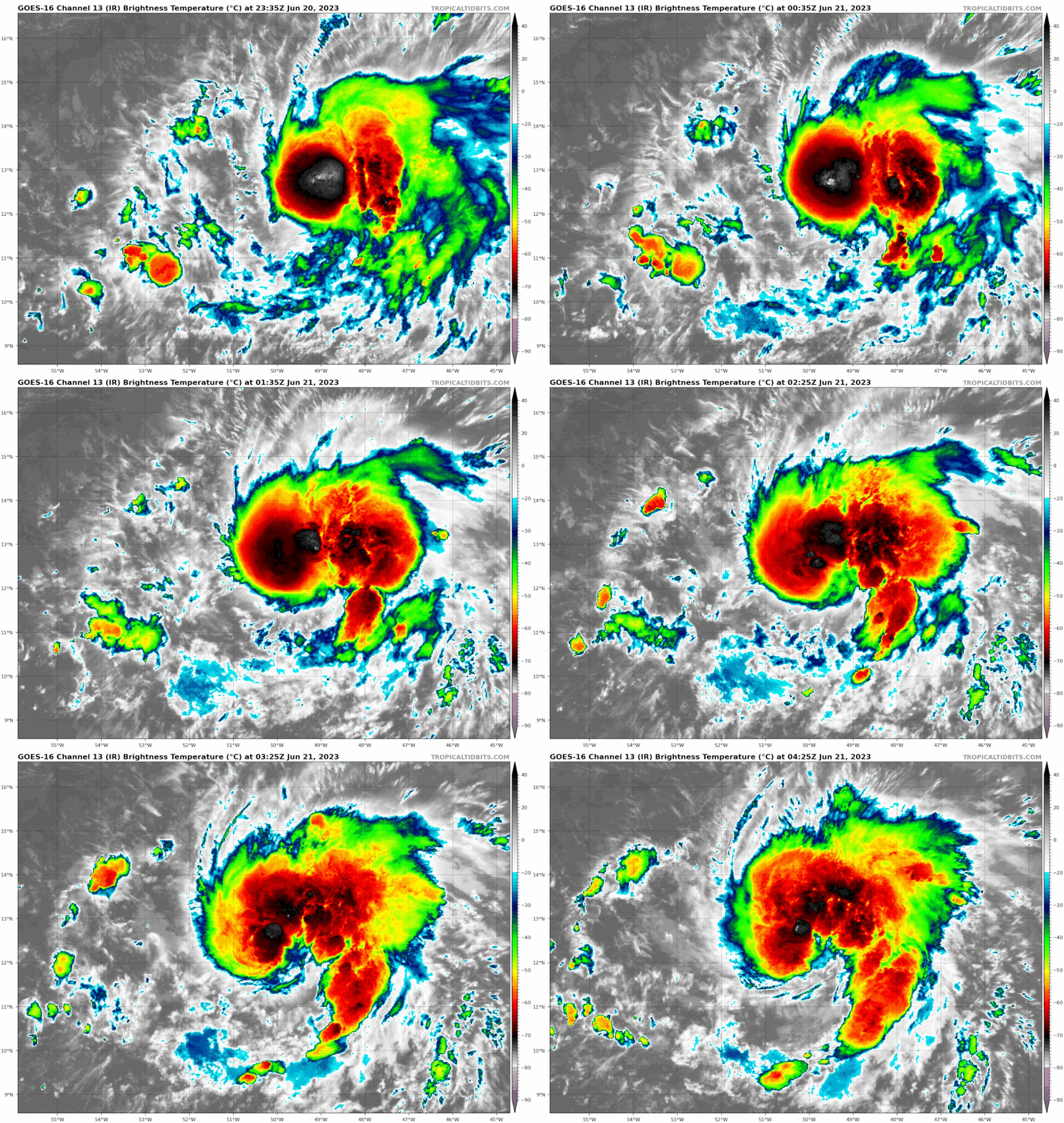
#365 Postby Teban54 » Tue Jun 20, 2023 11:35 pm

An angry Atlantic shrimp.

Based on my amateur eyeballing of the shortwave IR imagery, it seems that the LLC might also be tucked in under the convection now, instead of at the edge.
Image
4 likes   

User avatar
cheezyWXguy
Category 5
Category 5
Posts: 6108
Joined: Mon Feb 13, 2006 12:29 am
Location: Dallas, TX

Re: ATL: BRET - Tropical Storm - Discussion

#366 Postby cheezyWXguy » Wed Jun 21, 2023 12:47 am

Teban54 wrote:An angry Atlantic shrimp.

Based on my amateur eyeballing of the shortwave IR imagery, it seems that the LLC might also be tucked in under the convection now, instead of at the edge.
https://i.postimg.cc/mgSMZr5F/goes16-ir-03-L-202306202335.gif

Agreed, based on shortwave ir “nighttime vis” it looks to me like the center is directly under the latest deep convective burst. Curious to see if this will continue through the night, unlike last night
3 likes   

User avatar
ElectricStorm
Category 5
Category 5
Posts: 5044
Age: 24
Joined: Tue Aug 13, 2019 11:23 pm
Location: Skiatook, OK / Norman, OK

Re: ATL: BRET - Tropical Storm - Discussion

#367 Postby ElectricStorm » Wed Jun 21, 2023 1:50 am

03L BRET 230621 0600 12.7N 50.7W ATL 45 1003
0 likes   
B.S Meteorology, University of Oklahoma '25

Please refer to the NHC, NWS, or SPC for official information.

User avatar
Hammy
Category 5
Category 5
Posts: 5849
Age: 41
Joined: Fri May 25, 2012 5:25 pm
Contact:

Re: ATL: BRET - Tropical Storm - Discussion

#368 Postby Hammy » Wed Jun 21, 2023 2:01 am

cheezyWXguy wrote:
Teban54 wrote:An angry Atlantic shrimp.

Based on my amateur eyeballing of the shortwave IR imagery, it seems that the LLC might also be tucked in under the convection now, instead of at the edge.
https://i.postimg.cc/mgSMZr5F/goes16-ir-03-L-202306202335.gif

Agreed, based on shortwave ir “nighttime vis” it looks to me like the center is directly under the latest deep convective burst. Curious to see if this will continue through the night, unlike last night


Image

NASA's site seems to confirm this, it was exposed just a bit to the southeast of the convection earlier, and has since wrapped back around
0 likes   
The above post is not official and should not be used as such. It is the opinion of the poster and may or may not be backed by sound meteorological data. It is not endorsed by any professional institution or storm2k.org. For official information, please refer to the NHC and NWS products.

Chemmers
Tropical Storm
Tropical Storm
Posts: 220
Joined: Wed Jul 22, 2020 6:16 am

Re: ATL: BRET - Tropical Storm - Discussion

#369 Postby Chemmers » Wed Jun 21, 2023 6:36 am

looking healthy on satellite this morning
0 likes   

User avatar
NDG
S2K Supporter
S2K Supporter
Posts: 15446
Joined: Sun Jul 09, 2006 10:14 pm
Location: Orlando, FL

Re: ATL: BRET - Tropical Storm - Discussion

#370 Postby NDG » Wed Jun 21, 2023 6:44 am

Hard to tell on visible satellite since the LLC is not exposed this morning I would guess is within the red circle I placed.

Image
3 likes   

User avatar
kevin
Category 5
Category 5
Posts: 2586
Age: 26
Joined: Wed Aug 28, 2019 4:35 am

Re: ATL: BRET - Tropical Storm - Discussion

#371 Postby kevin » Wed Jun 21, 2023 6:55 am

Looking very good imo

2 likes   

Nuno
Category 2
Category 2
Posts: 597
Joined: Fri Aug 30, 2019 8:35 am
Location: Coral Gables, FL

Re: ATL: BRET - Tropical Storm - Discussion

#372 Postby Nuno » Wed Jun 21, 2023 7:25 am

Now the NHC forecast seems too conservative for strength. No longer exposed, improved outflow, less shear. Definitely strengthening at the moment.
3 likes   
Andrew (1992), Irene (1999), Frances (2004), Katrina (2005), Wilma (2005), Fay (2008), Irma (2017), Eta (2020), Ian (2022)

User avatar
NDG
S2K Supporter
S2K Supporter
Posts: 15446
Joined: Sun Jul 09, 2006 10:14 pm
Location: Orlando, FL

Re: ATL: BRET - Tropical Storm - Discussion

#373 Postby NDG » Wed Jun 21, 2023 7:33 am

Nuno wrote:Now the NHC forecast seems too conservative for strength. No longer exposed, improved outflow, less shear. Definitely strengthening at the moment.


Euro is still persistent in strengthening some today through tonight, down to 994mb for a quick period, per the latest 06z run.
0 likes   

User avatar
cycloneye
Admin
Admin
Posts: 145296
Age: 68
Joined: Thu Oct 10, 2002 10:54 am
Location: San Juan, Puerto Rico

Re: ATL: BRET - Tropical Storm - Discussion

#374 Postby cycloneye » Wed Jun 21, 2023 7:38 am

TXNT28 KNES 211218
TCSNTL

A. 03L (BRET)

B. 21/1130Z

C. 12.9N

D. 51.9W

E. THREE/GOES-E

F. T3.5/3.5

G. IR/EIR/VIS

H. REMARKS...8/10 BANDING YIELDS A DT OF 3.5. THE MET IS 3.5 BASED ON
A 24 HR DEVELOPING TREND. THE PT IS ALSO 3.5. THE FT IS BASED ON THE DT.

I. ADDL POSITIONS

NIL


...GATLING
0 likes   
Visit the Caribbean-Central America Weather Thread where you can find at first post web cams,radars
and observations from Caribbean basin members Click Here

User avatar
cycloneye
Admin
Admin
Posts: 145296
Age: 68
Joined: Thu Oct 10, 2002 10:54 am
Location: San Juan, Puerto Rico

Re: ATL: BRET - Tropical Storm - Discussion

#375 Postby cycloneye » Wed Jun 21, 2023 7:45 am

Up to 55kt.

AL, 03, 2023062112, , BEST, 0, 129N, 519W, 55, 1000, TS
3 likes   
Visit the Caribbean-Central America Weather Thread where you can find at first post web cams,radars
and observations from Caribbean basin members Click Here

User avatar
kevin
Category 5
Category 5
Posts: 2586
Age: 26
Joined: Wed Aug 28, 2019 4:35 am

Re: ATL: BRET - Tropical Storm - Discussion

#376 Postby kevin » Wed Jun 21, 2023 7:45 am

cycloneye wrote:
TXNT28 KNES 211218
TCSNTL

A. 03L (BRET)

B. 21/1130Z

C. 12.9N

D. 51.9W

E. THREE/GOES-E

F. T3.5/3.5

G. IR/EIR/VIS

H. REMARKS...8/10 BANDING YIELDS A DT OF 3.5. THE MET IS 3.5 BASED ON
A 24 HR DEVELOPING TREND. THE PT IS ALSO 3.5. THE FT IS BASED ON THE DT.

I. ADDL POSITIONS

NIL


...GATLING


T3.5 together with the improved visual imagery should be sufficient for an upgrade to 55 kt imo for the next advisory.

Edit: nevermind, they already did
3 likes   

User avatar
Category5Kaiju
Category 5
Category 5
Posts: 4095
Joined: Thu Dec 24, 2020 12:45 pm
Location: Seattle

Re: ATL: BRET - Tropical Storm - Discussion: Best Track up to 55kt

#377 Postby Category5Kaiju » Wed Jun 21, 2023 7:53 am

Just woke up...and wow. Bret really got its act together overnight. In a sense, it kind of reminds me of Fiona last year, where that storm struggled for a bit with shear but then suddenly got its act together once it found slightly better conditions.
0 likes   
Unless explicitly stated, all info in my posts is based on my own opinions and observations. Tropical storms and hurricanes can be extremely dangerous. Do not think you can beat Mother Nature. Refer to an accredited weather research agency or meteorologist if you need to make serious decisions regarding an approaching storm.

User avatar
GCANE
S2K Supporter
S2K Supporter
Posts: 11496
Joined: Mon Oct 22, 2007 8:03 am

Re: ATL: BRET - Tropical Storm - Discussion: Best Track up to 55kt

#378 Postby GCANE » Wed Jun 21, 2023 8:00 am

Strong outflow is taking a big bite out of shear.
Decimating those thunderstorms to the west at about 57W
1 likes   

User avatar
GCANE
S2K Supporter
S2K Supporter
Posts: 11496
Joined: Mon Oct 22, 2007 8:03 am

Re: ATL: BRET - Tropical Storm - Discussion: Best Track up to 55kt

#379 Postby GCANE » Wed Jun 21, 2023 8:07 am

Looks like CAPE & TPW entrainment will significantly increase as Bret is just about to hit the islands.
Will be in the middle of an anti-cyclone.
Could see some decent intensification then.
1 likes   

User avatar
GCANE
S2K Supporter
S2K Supporter
Posts: 11496
Joined: Mon Oct 22, 2007 8:03 am

Re: ATL: BRET - Tropical Storm - Discussion: Best Track up to 55kt

#380 Postby GCANE » Wed Jun 21, 2023 8:11 am

Looks like when it gets south of Jamica there maybe some light steering at 500mb to make it take a turn to the NW.
0 likes   


Return to “2023”

Who is online

Users browsing this forum: No registered users and 1 guest