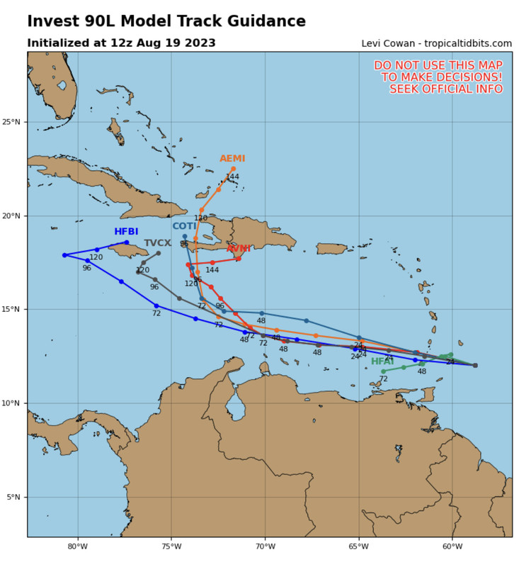
ATL: FRANKLIN - Models
Moderator: S2k Moderators


Re: ATL: INVEST 90L - Models
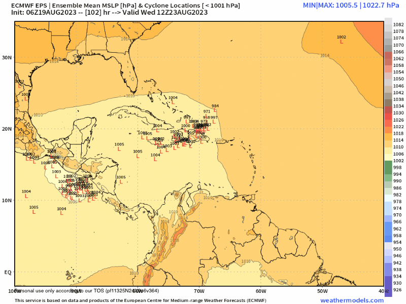
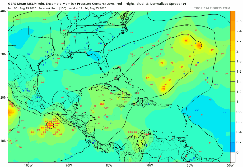
Nearly 100% chance by EPS of becoming a TD, 40-50% of becoming a TS before reaching Hispaniola area.

0 likes

Re: ATL: INVEST 90L - Models
NDG wrote:Nearly 100% chance by EPS of becoming a TD, 40-50% of becoming a TS before reaching Hispaniola area.
https://i.imgur.com/MlEiw3h.png
That’s a strong trough that would pull that due north across Hispaniola that far south.I wonder if that would actually happen.
0 likes
-
Blown Away

- S2K Supporter

- Posts: 10253
- Joined: Wed May 26, 2004 6:17 am
Re: ATL: INVEST 90L - Models
06z EPS breaking off a few to the NW after Hispaniola now.
0 likes
Hurricane Eye Experience: David 79, Irene 99, Frances 04, Jeanne 04, Wilma 05… Hurricane Brush Experience: Andrew 92, Erin 95, Floyd 99, Matthew 16, Irma 17, Ian 22, Nicole 22…
-
Spacecoast

- Category 2

- Posts: 773
- Joined: Thu Aug 31, 2017 2:03 pm
Re: ATL: INVEST 90L - Models
boca wrote:NDG wrote:Nearly 100% chance by EPS of becoming a TD, 40-50% of becoming a TS before reaching Hispaniola area.
https://i.imgur.com/MlEiw3h.png
That’s a strong trough that would pull that due north across Hispaniola that far south.I wonder if that would actually happen.
6z GEFS indicates there's a good chance....

0 likes
Re: ATL: INVEST 90L - Models
boca wrote:NDG wrote:Nearly 100% chance by EPS of becoming a TD, 40-50% of becoming a TS before reaching Hispaniola area.
https://i.imgur.com/MlEiw3h.png
That’s a strong trough that would pull that due north across Hispaniola that far south.I wonder if that would actually happen.
Is a mid to UL low from a result of wave breaking rotating around the US stacked heat ridge that will create a weakness to its north, the stronger it gets before reaching 70W the faster it will feel the weakness as shown by the latest EPS ensembles.

1 likes
-
Blown Away
- S2K Supporter
- Posts: 10253
- Joined: Wed May 26, 2004 6:17 am
Re: ATL: INVEST 90L - Models
12z… Models keep drifting farther W… AEMI has realistic track, just not buying sharp NE turn from Caribbean in August… Something has to give, move farther W or no development…
0 likes
Hurricane Eye Experience: David 79, Irene 99, Frances 04, Jeanne 04, Wilma 05… Hurricane Brush Experience: Andrew 92, Erin 95, Floyd 99, Matthew 16, Irma 17, Ian 22, Nicole 22…
-
Blown Away
- S2K Supporter
- Posts: 10253
- Joined: Wed May 26, 2004 6:17 am
Re: ATL: INVEST 90L - Models
12z GFS… Initiates at 1001 mb and goes WNW… Decent W shift and Cat 1/2 hurricane N of Hispaniola… JMHO, I think there is a very fine line after @126 hrs between OTS and getting blocked back W…
Last edited by Blown Away on Sat Aug 19, 2023 11:37 am, edited 6 times in total.
0 likes
Hurricane Eye Experience: David 79, Irene 99, Frances 04, Jeanne 04, Wilma 05… Hurricane Brush Experience: Andrew 92, Erin 95, Floyd 99, Matthew 16, Irma 17, Ian 22, Nicole 22…
-
gatorcane

- S2K Supporter
- Posts: 23708
- Age: 48
- Joined: Sun Mar 13, 2005 3:54 pm
- Location: Boca Raton, FL
Re: ATL: INVEST 90L - Models
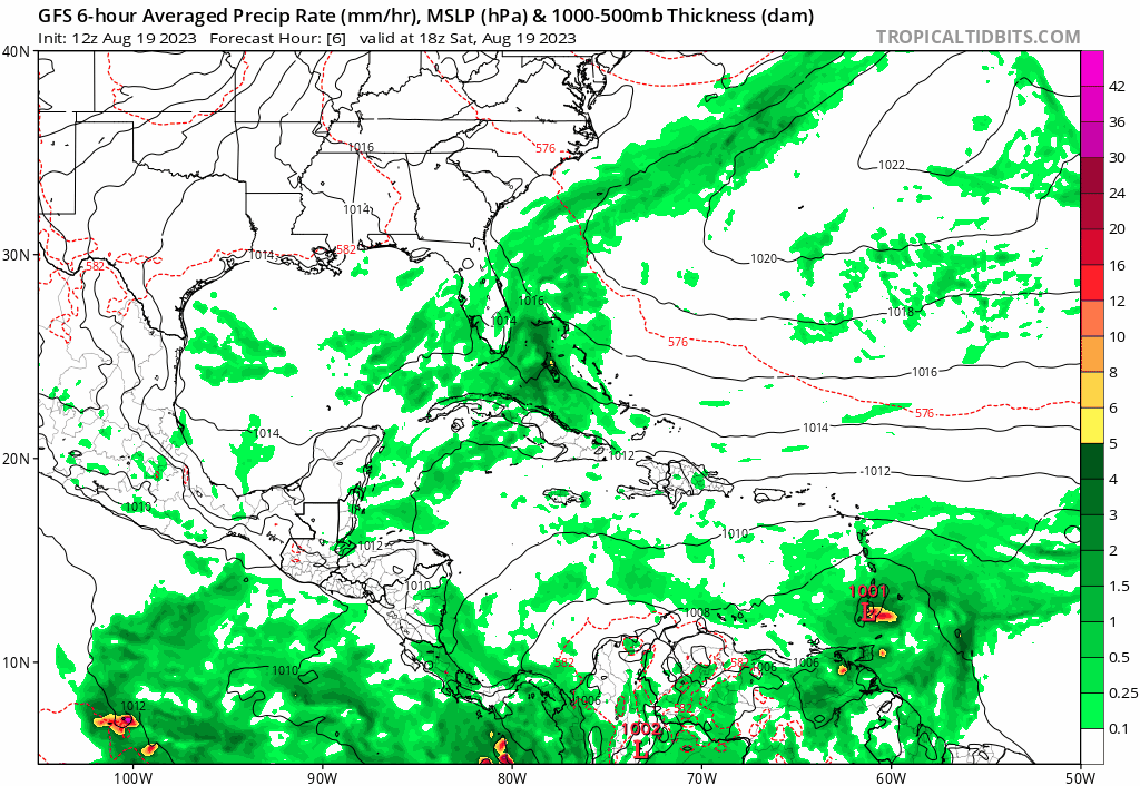
The GFS now showing development so appears development chances are increasing though shear and land interaction should limit significant development.
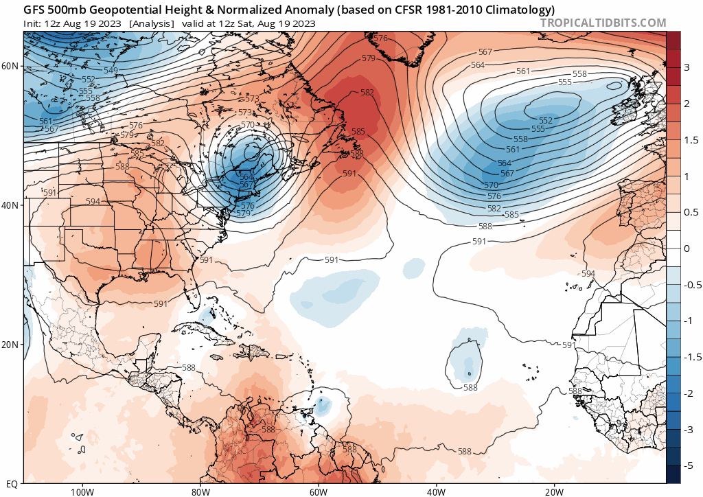
How about that trough to yank it out of the Caribbean and pull it NE or even ENE? The Bermuda high has literally been eliminated. Not something you see too often this time of year but timely indeed for the SE US and Bahamas:
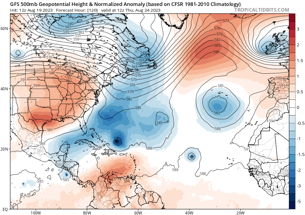
How about that trough to yank it out of the Caribbean and pull it NE or even ENE? The Bermuda high has literally been eliminated. Not something you see too often this time of year but timely indeed for the SE US and Bahamas:
0 likes
-
CourierPR

- Category 5

- Posts: 1336
- Age: 72
- Joined: Tue Aug 31, 2004 7:53 pm
- Location: Pompano Beach, Florida
Re: ATL: INVEST 90L - Models
gatorcane wrote:The GFS now showing development so appears development chances are increasing though shear and land interaction should limit significant development.
How about that trough to yank it out of the Caribbean and pull it NE or even ENE? The Bermuda high has literally been eliminated. Not something you see too often this time of year but timely indeed for the SE US and Bahamas.
Timely only if it indeed comes to fruition.
1 likes
-
gatorcane
- S2K Supporter
- Posts: 23708
- Age: 48
- Joined: Sun Mar 13, 2005 3:54 pm
- Location: Boca Raton, FL
Re: ATL: INVEST 90L - Models
With the absence of a Bermuda High, Bermuda might need to watch closely. GFS 0 to 174 hour loop, 500MB heights:
0 likes
-
Blown Away
- S2K Supporter
- Posts: 10253
- Joined: Wed May 26, 2004 6:17 am
Re: ATL: INVEST 90L - Models
gatorcane wrote:With the absence of a Bermuda High, Bermuda might need to watch closely. GFS 0 to 174 hour loop, 500MB heights:
https://i.postimg.cc/FzzTwBs8/gfs-z500a-Norm-atl-fh0-174.gif
Bermuda in the crosshairs. Models keep trending 90L W even w/ the giant trough and that zig W then zag NE from deep Caribbean in August would be extremely rare. I think adding a little climatology to the modeling says points farther W.
0 likes
Hurricane Eye Experience: David 79, Irene 99, Frances 04, Jeanne 04, Wilma 05… Hurricane Brush Experience: Andrew 92, Erin 95, Floyd 99, Matthew 16, Irma 17, Ian 22, Nicole 22…
Re: ATL: INVEST 90L - Models
No doubt the La Nina like stacked ridge over the central US will protect the US from Hilary with all those breaking waves rotating around it on its E & S sides will keep a weakness to the north of Hispaniola for 90L to take advantage of.

0 likes
-
Blown Away
- S2K Supporter
- Posts: 10253
- Joined: Wed May 26, 2004 6:17 am
Re: ATL: INVEST 90L - Models
12z ICON… Shift W & stronger… Complex environment once 90L gets above Hispaniola, drifting around for a while and then OTS, for now.
0 likes
Hurricane Eye Experience: David 79, Irene 99, Frances 04, Jeanne 04, Wilma 05… Hurricane Brush Experience: Andrew 92, Erin 95, Floyd 99, Matthew 16, Irma 17, Ian 22, Nicole 22…
-
Blown Away
- S2K Supporter
- Posts: 10253
- Joined: Wed May 26, 2004 6:17 am
Re: ATL: INVEST 90L - Models
12z GEFS… Still majority OTS after the GA’s, but first time in a while leaving a few ensembles behind in SE Bahamas..
0 likes
Hurricane Eye Experience: David 79, Irene 99, Frances 04, Jeanne 04, Wilma 05… Hurricane Brush Experience: Andrew 92, Erin 95, Floyd 99, Matthew 16, Irma 17, Ian 22, Nicole 22…
-
AtlanticWind

- S2K Supporter
- Posts: 1898
- Age: 67
- Joined: Sun Aug 08, 2004 9:57 pm
- Location: Plantation,Fla
Re: ATL: INVEST 90L - Models
Euro farther west in Caribbean thru 72hours
Turns north sharply at 96
Turns north sharply at 96
0 likes
-
Blown Away
- S2K Supporter
- Posts: 10253
- Joined: Wed May 26, 2004 6:17 am
Re: ATL: INVEST 90L - Models
AtlanticWind wrote:Euro farther west in Caribbean thru 72hours
Turns north sharply at 96
12z Euro… Another shift W
0 likes
Hurricane Eye Experience: David 79, Irene 99, Frances 04, Jeanne 04, Wilma 05… Hurricane Brush Experience: Andrew 92, Erin 95, Floyd 99, Matthew 16, Irma 17, Ian 22, Nicole 22…
-
Blown Away
- S2K Supporter
- Posts: 10253
- Joined: Wed May 26, 2004 6:17 am
Re: ATL: INVEST 90L - Models
Blown Away wrote:AtlanticWind wrote:Euro farther west in Caribbean thru 72hours
Turns north sharply at 96
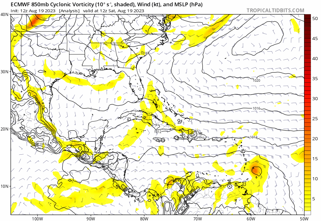
[url]https://i.postimg.cc/QMgZbSgh/ec-fast-uv850-vort-watl-fh0-120.gif [/url]
12z Euro… Another shift W
0 likes
Hurricane Eye Experience: David 79, Irene 99, Frances 04, Jeanne 04, Wilma 05… Hurricane Brush Experience: Andrew 92, Erin 95, Floyd 99, Matthew 16, Irma 17, Ian 22, Nicole 22…

Re: ATL: INVEST 90L - Models
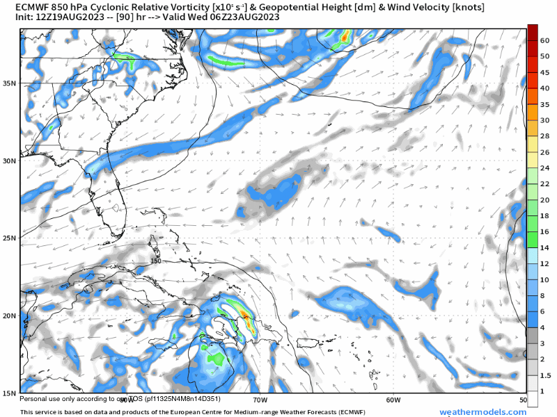
12z GFS ensembles. Looks like some members don't make the sharp north turn, and even some that do hint at a NW bend at the end. 
Sent from my iPhone using Tapatalk
Sent from my iPhone using Tapatalk
0 likes
Who is online
Users browsing this forum: No registered users and 36 guests