ATL: MILTON - Post-Tropical - Discussion

Moderator: S2k Moderators

Message
Author
caneman
Category 5
Category 5
Posts: 1447
Joined: Fri Sep 05, 2014 5:44 am
Location: Clearwater Beach, Fl

Re: ATL: FOURTEEN - Tropical Depression - Discussion

#181 Postby caneman » Sat Oct 05, 2024 11:07 am

Zonacane wrote:What is the expected storm surge for a category 4 in Tampa?


I would think quite a bit worse than Helene as it would be direct and coming from the worst possible angle for surge
1 likes   

skillz305
Category 1
Category 1
Posts: 279
Joined: Sat Sep 08, 2018 11:10 am
Location: Miami, Florida --> Vero Beach, Florida

Re: ATL: FOURTEEN - Tropical Depression - Discussion

#182 Postby skillz305 » Sat Oct 05, 2024 11:11 am

Treasure Coast here: Got my gas, water, canned food, batteries, flashlights, etc (this is prepping for electrical outage not a doomsday scenario). PLEASE start preparing if you're in Central Florida before mass panic sets in. The gas stations and stores are packed and we are on the east coast. Stay safe everyone and keep your head on a swivel.
8 likes   
:flag:Hurricanes: Andrew 1992 - Irene 1999 - Frances 2004 - Jeanne 2004 - Katrina 2005 - Wilma 2005 - Matthew 2016 - Irma 2017 - Ian 2022 - Nicole 2022 - Milton 2024

User avatar
toad strangler
S2K Supporter
S2K Supporter
Posts: 4543
Joined: Sun Jul 28, 2013 3:09 pm
Location: Earth
Contact:

Re: ATL: FOURTEEN - Tropical Depression - Discussion

#183 Postby toad strangler » Sat Oct 05, 2024 11:13 am

skillz305 wrote:Treasure Coast here: Got my gas, water, canned food, batteries, flashlights, etc (this is prepping for electrical outage not a doomsday scenario). PLEASE start preparing if you're in Central Florida before mass panic sets in. The gas stations and stores are packed and we are on the east coast. Stay safe everyone and keep your head on a swivel.


Just got back from topping off my supply list. I’m always about 90% ready during the season to begin with so I’m good to go. But yeah, People are getting the message. Stores were packed early in Port St. Lucie
9 likes   

underthwx
Category 5
Category 5
Posts: 2360
Joined: Sat Jul 30, 2011 2:14 pm
Location: Brazoria County Texas

Re: ATL: FOURTEEN - Tropical Depression - Discussion

#184 Postby underthwx » Sat Oct 05, 2024 11:16 am

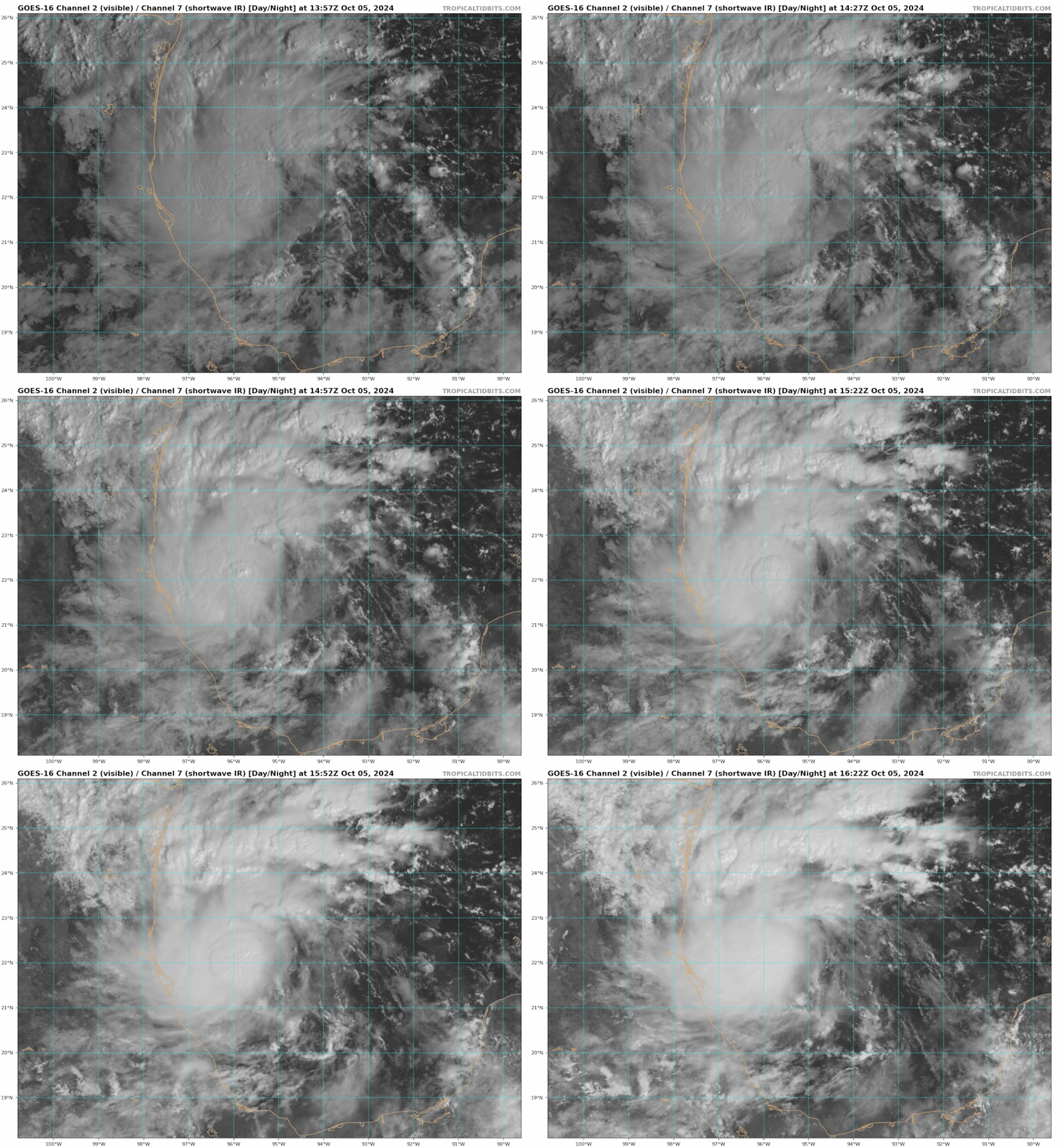
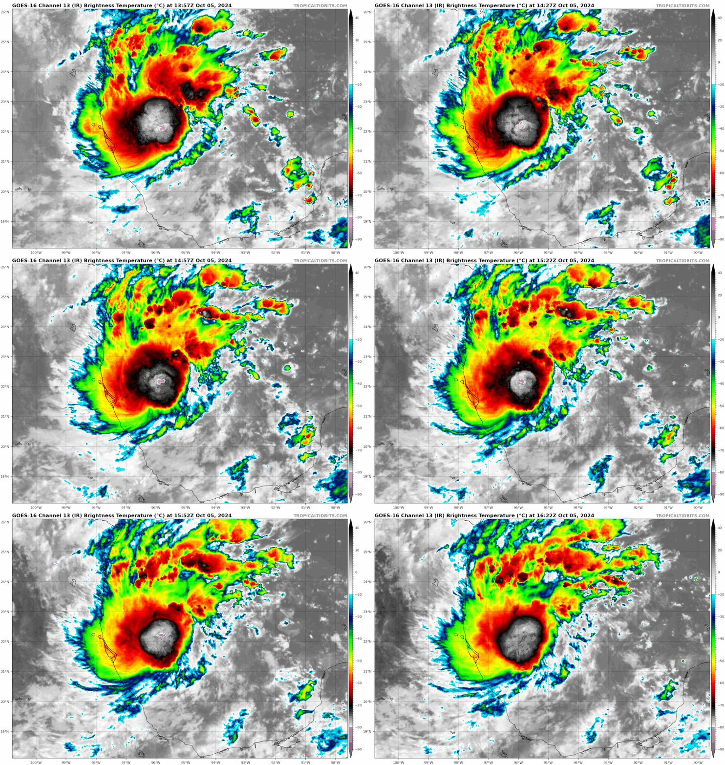
TD 14 looking better organized on satellite....compared to an hour or so ago....I will not be surprised to see intensities nudge upwards as time goes by....probably Tropical Storm by this evening?....
2 likes   

User avatar
Teban54
Category 5
Category 5
Posts: 3204
Joined: Sat May 19, 2018 1:19 pm

Re: ATL: FOURTEEN - Tropical Depression - Discussion

#185 Postby Teban54 » Sat Oct 05, 2024 11:17 am

Teban54 wrote:With a 95 kt first advisory for TD 14, I have to pull out the list of most aggressive first advisories yet again, originally compiled by Kevin.

It's absolutely insane that 2024 has already put 6 TCs on the list (Beryl, Ernesto, Helene, Kirk, Leslie, TD 14), even though Ernesto and possibly Leslie have underperformed. On the other hand, it could also suggest the NHC has become more aggressive with first advisories in recent years, either due to improved model accuracy and confidence, or for better effectiveness at public messaging.

As of October 5, 2024, here is the updated version for the first advisory peak intensity. Based on NHC advisories since 1998 (of which the 1998 - 2002 advisories only went to +72 hrs).

120 kt
2023 - Lee

105 kt
2024 - Kirk
2023 - Nigel

100 kt
2021 - Sam
2010 - Tomas

95 kt
2024 - TD 14
2024 - Helene
2024 - Ernesto
2022 - Ian
2021 - Ida
2020 - Iota
2019 - Lorenzo
2012 - Isaac
2010 - Danielle
2005 - Philippe
2004 - Karl

90 kt
2024 - Beryl
2021 - Larry
2017 - Jose
2016 - Matthew
2009 - Bill
2007 - Dean

85 kt
2020 - Delta
2015 - Danny
2014 - Gonzalo
2011 - Katia
2010 - Igor
2010 - Earl
2006 - Helene
2005 - Wilma

80 kt
2024 - Leslie
2022 - Danielle
2020 - Teddy
2019 - Jerry
2017 - Maria
2017 - Irma
2016 - Gaston
2012 - Leslie
2005 - Rita
2004 - Earl
1999 - Emily

I may want to add the verified intensities at the specified time frames later, but can't do it now.

Contributions by year
2024: 6 storms (Kirk 105, Milton 95, Helene 95, Ernesto 95, Beryl 90, Leslie 80)
2010: 4 storms (Tomas 100, Danielle 95, Igor 85, Earl 85)
2021: 3 storms (Sam 100, Ida 95, Larry 90)
2017: 3 storms (Jose 90, Maria 80, Irma 80)
2005: 3 storms (Philippe 95, Wilma 85, Rita 80)
Years with 2 storms: 2023, 2022, 2020, 2019, 2016, 2012, 2004
Years with 1 storm: 2015, 2014, 2011, 2009, 2007, 2006, 1999

Also, interestingly, Helene and Leslie are the only names that appeared twice on this list.
5 likes   

User avatar
toad strangler
S2K Supporter
S2K Supporter
Posts: 4543
Joined: Sun Jul 28, 2013 3:09 pm
Location: Earth
Contact:

Re: ATL: FOURTEEN - Tropical Depression - Discussion

#186 Postby toad strangler » Sat Oct 05, 2024 11:18 am

1st AOI to last AOI before classification. It shows right here how off the thinking was early. Wrong piece of energy.
Image
Image
3 likes   

User avatar
StPeteMike
Category 2
Category 2
Posts: 631
Joined: Thu Jun 07, 2018 11:26 pm

Re: ATL: FOURTEEN - Tropical Depression - Discussion

#187 Postby StPeteMike » Sat Oct 05, 2024 11:18 am

skillz305 wrote:Treasure Coast here: Got my gas, water, canned food, batteries, flashlights, etc (this is prepping for electrical outage not a doomsday scenario). PLEASE start preparing if you're in Central Florida before mass panic sets in. The gas stations and stores are packed and we are on the east coast. Stay safe everyone and keep your head on a swivel.

100%! Think people have seen what a storm 100 miles away does to this area. They won’t take anything for granted.
4 likes   
The above post is not official and should not be used as such. It is the opinion of the poster and may or may not be backed by sound meteorological data. It is not endorsed by any professional institution or storm2k.org. For official information, please refer to the NHC and NWS products.

Michele B
S2K Supporter
S2K Supporter
Posts: 1114
Joined: Thu Aug 25, 2016 8:08 am
Location: SWFL

Re: ATL: INVEST 92L - Discussion

#188 Postby Michele B » Sat Oct 05, 2024 11:19 am

aspen wrote:
Pipelines182 wrote:
aspen wrote:Only the HWRF shows an unquestionable major. HAFS-A gets it into the 920s but is extremely suspect because it shows a heavily sheared system with only half an eyewall. HAFS-B is probably more realistic, a sheared Cat 1-2. Perhaps something like Francine.


HMON gets down to 928, GFS 944, HWRF 922. The best three intensity models all show an unquestionable major. The HAFS models need work, they havent shown to be much accuracy with intensity forecasts yet.

I’m still a little skeptical because this is such a weird track that could very easily impart a lot of shear. Even on the HWRF, shear takes its toll as 92L approaches Florida. This doesn’t look like a track conducive for ventilating shear like Michael, Ian, or Helene.

Not saying “don’t prepare for a major”, because in a situation like this it’s better to over-prepare than under. I’m just saying I’m suspicious of this blowing up to the degree some models are showing because of its track and angle.


Yep, it is pretty unprecedented. That's what makes it a 2024 storm!! :cheesy:
5 likes   
Cleo - 1964, Betsy - 1965, David - 1979, Andrew - 1992, Charlie (Francis, Ivan, Jeanne) - 2004, Irma - 2017, Ian - 2022

Hugo1989
Tropical Storm
Tropical Storm
Posts: 147
Joined: Mon Jun 14, 2010 9:09 am

Re: ATL: FOURTEEN - Tropical Depression - Discussion

#189 Postby Hugo1989 » Sat Oct 05, 2024 11:19 am

I can’t imagine this eye of a cat 3 moving across the Tampa bay! Water surge, winds and rain would catastrophic. There are too many houses (most of them mansions) around the bay. All the damages causes will be historic. Nobody is ready to watch this scenario!
1 likes   

underthwx
Category 5
Category 5
Posts: 2360
Joined: Sat Jul 30, 2011 2:14 pm
Location: Brazoria County Texas

Re: ATL: FOURTEEN - Tropical Depression - Discussion

#190 Postby underthwx » Sat Oct 05, 2024 11:20 am

skillz305 wrote:Treasure Coast here: Got my gas, water, canned food, batteries, flashlights, etc (this is prepping for electrical outage not a doomsday scenario). PLEASE start preparing if you're in Central Florida before mass panic sets in. The gas stations and stores are packed and we are on the east coast. Stay safe everyone and keep your head on a swivel.

Yup....east coast of Florida should be preparing as well....this will be an event that will affect both coasts of Florida unfortunately....I wish it were not so....but it is what it is.....its reassuring to hear that the word is out on soon to be Milton...I wish all of you the best possible outcome...to a growing threat to your region....
3 likes   

Hugo1989
Tropical Storm
Tropical Storm
Posts: 147
Joined: Mon Jun 14, 2010 9:09 am

Re: ATL: FOURTEEN - Tropical Depression - Discussion

#191 Postby Hugo1989 » Sat Oct 05, 2024 11:20 am

I can’t imagine this eye of a cat 3 moving across the Tampa bay! Water surge, winds and rain would catastrophic. There are too many houses (most of them mansions) around the bay. All the damages causes will be historic. Nobody is ready to watch this scenario!
1 likes   

User avatar
HurricaneBelle
S2K Supporter
S2K Supporter
Posts: 1179
Joined: Sun Aug 27, 2006 6:12 pm
Location: Clearwater, FL

Re: ATL: FOURTEEN - Tropical Depression - Discussion

#192 Postby HurricaneBelle » Sat Oct 05, 2024 11:26 am

That 12Z GFS run takes the eye right over me Wednesday morning. Or perhaps I should say right over my house because if that still looks like the landfall location in a couple of days, I might be hitting the road.

Two years ago I was fleein' Ian, this time I might be jiltin' Milton.
14 likes   

User avatar
Xyls
Tropical Storm
Tropical Storm
Posts: 162
Joined: Thu Sep 07, 2023 3:48 pm
Location: New Brunswick, Canada

Re: ATL: FOURTEEN - Tropical Depression - Discussion

#193 Postby Xyls » Sat Oct 05, 2024 11:27 am

These models runs are getting unsettling. I don't think there is any city in the U.S. more vulnerable to a major hurricane strike than Tampa Bay, not even New Orleans. Yes, a Cat 5 into Miami or a Cat 3 into New York potentially could do more damage. But as far as potential for loss of life I think a major hurricane into Tampa Bay, potentially angled just north of the bay as to drive a storm surge into it is just about the worst case scenario possible.

If this is the scenario we are looking at, then decisions need to be made about an evacuation of much of the city probably within the next 24 hours if these models stay consistent. Because at this point time is of the essence. This is still risky because if the hurricane track goes just to the south of the bay then potentially that may cause some of the truly apocalyptic storm surge models for Tampa Bay not to come to fruition and then this becomes a question of are we risking more people during an evacuation of the metro like after Hurricane Rita in 2005 or are we risking a more chaotic and unsuccessful evacuation of the city if the decision is delayed too long potentially leading to a Katrina like situation. Tampa is a nearly 3X larger metro than New Orleans was in 2005. And unlike in Houston where yes a hurricane would be bad but the storm surge wouldn't drown the whole city, Tampa especially on it's peninsula and in the downtown could very well see 20 foot+ storm surges in a worst case.

I see some models trend down with the intensity of the system right before it makes landfall, but again analogous to Katrina I wouldn't put much stock in that if this gets to be an intense Category 4 in the gulf, even if it weakens to Cat 2-3 winds before landfall you are probably still looking at a Cat 4 surge due to the momentum of the water. I would hate to be the one making decisions on evacuations and preparations right now. We probably have another 12 hours to see what the next models will do today. If they stay consistent with a Tampa Bay north side solution than I think someone is going to have to pull the trigger.

Also the rain that is projected ahead of this system could hinder the evacuations if there is going to be flooding, and anyone trying to evacuate where exactly do you go? All to Miami? Because if you are going North you are going to be hindered by the devastation in the areas of Hurricane Helene?

Yikes. Let's hope the models start suggesting something else.
Last edited by Xyls on Sat Oct 05, 2024 11:39 am, edited 2 times in total.
7 likes   
Not a professional meteorologist. Please refer to NHC forecasts for official information/advice relating to tropical systems.

User avatar
wzrgirl1
S2K Supporter
S2K Supporter
Posts: 1325
Joined: Sat Sep 04, 2004 6:44 am
Location: Pembroke Pines, Florida

Re: ATL: FOURTEEN - Tropical Depression - Discussion

#194 Postby wzrgirl1 » Sat Oct 05, 2024 11:28 am

Under the current forecast, I am about 75 miles east of Naples. What can I expect from this storm?
0 likes   

User avatar
Hurricaneman
Category 5
Category 5
Posts: 7351
Age: 45
Joined: Tue Aug 31, 2004 3:24 pm
Location: central florida

Re: ATL: FOURTEEN - Tropical Depression - Discussion

#195 Postby Hurricaneman » Sat Oct 05, 2024 11:28 am

Looks like it’s in a stacking phase right now but once finished it’s off to the races
1 likes   

User avatar
Teban54
Category 5
Category 5
Posts: 3204
Joined: Sat May 19, 2018 1:19 pm

Re: ATL: FOURTEEN - Tropical Depression - Discussion

#196 Postby Teban54 » Sat Oct 05, 2024 11:31 am

Already looks like it's taking shape. Yikes.

Image
Image
2 likes   

underthwx
Category 5
Category 5
Posts: 2360
Joined: Sat Jul 30, 2011 2:14 pm
Location: Brazoria County Texas

Re: ATL: FOURTEEN - Tropical Depression - Discussion

#197 Postby underthwx » Sat Oct 05, 2024 11:32 am

HurricaneBelle wrote:That 12Z GFS run takes the eye right over me Wednesday morning. Or perhaps I should say right over my house because if that still looks like the landfall location in a couple of days, I might be hitting the road.

Two years ago I was fleein' Ian, this time I might be jiltin' Milton.

That makes sense....I learned the hard way from Harvey...a cyclone that landfalled over 300 miles south of where I lived....discretion being the better part of valor here....I agree with your thoughts on getting out of this cyclones way...until it passes...im not saying everyone get out now....im saying that as of right now...there is an imminent threat on the horizon...so your mindset is exactly how you should be thinking....I applaud your vigilance....best of luck to you and all of you in harms way.....peace
1 likes   

zzzh
Category 3
Category 3
Posts: 834
Joined: Thu Sep 02, 2021 1:13 pm

Re: ATL: FOURTEEN - Tropical Depression - Discussion

#198 Postby zzzh » Sat Oct 05, 2024 11:37 am


I think LLC is near the eastern edge of convection, need ascat/recon to see where the exact center is.
1 likes   

TomballEd
Category 2
Category 2
Posts: 690
Age: 61
Joined: Wed Aug 16, 2023 4:52 pm
Location: Spring/Klein area, not Tomball

Re: ATL: FOURTEEN - Tropical Depression - Discussion

#199 Postby TomballEd » Sat Oct 05, 2024 11:38 am

Captain Obvious, 50 mile difference, just N of Tampa with winds piling water into the bay, and just S of Tampa putting them on the weaker side with winds turning offshore, will make a huge difference and several days out (GFS, ICON and Canadian all disagree on timing by a fair amount, and the center probably won't be flown into before tomorrow) nobody can call this as far as that goes. 14L/Milton will pass over very warm water and may have strong baroclinic forcing ala Ian. Model posting just to show the spread, not trying to avoid posting in model thread

Image

Image
3 likes   

TomballEd
Category 2
Category 2
Posts: 690
Age: 61
Joined: Wed Aug 16, 2023 4:52 pm
Location: Spring/Klein area, not Tomball

Re: ATL: FOURTEEN - Tropical Depression - Discussion

#200 Postby TomballEd » Sat Oct 05, 2024 11:39 am

zzzh wrote:

I think LLC is near the eastern edge of convection, need ascat/recon to see where the exact center is.


If they have a crew and plane ready in Biloxi, a short fused mission not in today's Plan of the Day to get a better handle on 14L would be a very good thing.
2 likes   


Return to “2024”

Who is online

Users browsing this forum: No registered users and 4 guests