Zonacane wrote:What is the expected storm surge for a category 4 in Tampa?
I would think quite a bit worse than Helene as it would be direct and coming from the worst possible angle for surge
Moderator: S2k Moderators
Zonacane wrote:What is the expected storm surge for a category 4 in Tampa?

 Hurricanes: Andrew 1992 - Irene 1999 - Frances 2004 - Jeanne 2004 - Katrina 2005 - Wilma 2005 - Matthew 2016 - Irma 2017 - Ian 2022 - Nicole 2022 - Milton 2024

skillz305 wrote:Treasure Coast here: Got my gas, water, canned food, batteries, flashlights, etc (this is prepping for electrical outage not a doomsday scenario). PLEASE start preparing if you're in Central Florida before mass panic sets in. The gas stations and stores are packed and we are on the east coast. Stay safe everyone and keep your head on a swivel.
Teban54 wrote:With a 95 kt first advisory for TD 14, I have to pull out the list of most aggressive first advisories yet again, originally compiled by Kevin.
It's absolutely insane that 2024 has already put 6 TCs on the list (Beryl, Ernesto, Helene, Kirk, Leslie, TD 14), even though Ernesto and possibly Leslie have underperformed. On the other hand, it could also suggest the NHC has become more aggressive with first advisories in recent years, either due to improved model accuracy and confidence, or for better effectiveness at public messaging.
As of October 5, 2024, here is the updated version for the first advisory peak intensity. Based on NHC advisories since 1998 (of which the 1998 - 2002 advisories only went to +72 hrs).
120 kt
2023 - Lee
105 kt
2024 - Kirk
2023 - Nigel
100 kt
2021 - Sam
2010 - Tomas
95 kt
2024 - TD 14
2024 - Helene
2024 - Ernesto
2022 - Ian
2021 - Ida
2020 - Iota
2019 - Lorenzo
2012 - Isaac
2010 - Danielle
2005 - Philippe
2004 - Karl
90 kt
2024 - Beryl
2021 - Larry
2017 - Jose
2016 - Matthew
2009 - Bill
2007 - Dean
85 kt
2020 - Delta
2015 - Danny
2014 - Gonzalo
2011 - Katia
2010 - Igor
2010 - Earl
2006 - Helene
2005 - Wilma
80 kt
2024 - Leslie
2022 - Danielle
2020 - Teddy
2019 - Jerry
2017 - Maria
2017 - Irma
2016 - Gaston
2012 - Leslie
2005 - Rita
2004 - Earl
1999 - Emily
I may want to add the verified intensities at the specified time frames later, but can't do it now.


skillz305 wrote:Treasure Coast here: Got my gas, water, canned food, batteries, flashlights, etc (this is prepping for electrical outage not a doomsday scenario). PLEASE start preparing if you're in Central Florida before mass panic sets in. The gas stations and stores are packed and we are on the east coast. Stay safe everyone and keep your head on a swivel.
aspen wrote:Pipelines182 wrote:aspen wrote:Only the HWRF shows an unquestionable major. HAFS-A gets it into the 920s but is extremely suspect because it shows a heavily sheared system with only half an eyewall. HAFS-B is probably more realistic, a sheared Cat 1-2. Perhaps something like Francine.
HMON gets down to 928, GFS 944, HWRF 922. The best three intensity models all show an unquestionable major. The HAFS models need work, they havent shown to be much accuracy with intensity forecasts yet.
I’m still a little skeptical because this is such a weird track that could very easily impart a lot of shear. Even on the HWRF, shear takes its toll as 92L approaches Florida. This doesn’t look like a track conducive for ventilating shear like Michael, Ian, or Helene.
Not saying “don’t prepare for a major”, because in a situation like this it’s better to over-prepare than under. I’m just saying I’m suspicious of this blowing up to the degree some models are showing because of its track and angle.
skillz305 wrote:Treasure Coast here: Got my gas, water, canned food, batteries, flashlights, etc (this is prepping for electrical outage not a doomsday scenario). PLEASE start preparing if you're in Central Florida before mass panic sets in. The gas stations and stores are packed and we are on the east coast. Stay safe everyone and keep your head on a swivel.


HurricaneBelle wrote:That 12Z GFS run takes the eye right over me Wednesday morning. Or perhaps I should say right over my house because if that still looks like the landfall location in a couple of days, I might be hitting the road.
Two years ago I was fleein' Ian, this time I might be jiltin' Milton.
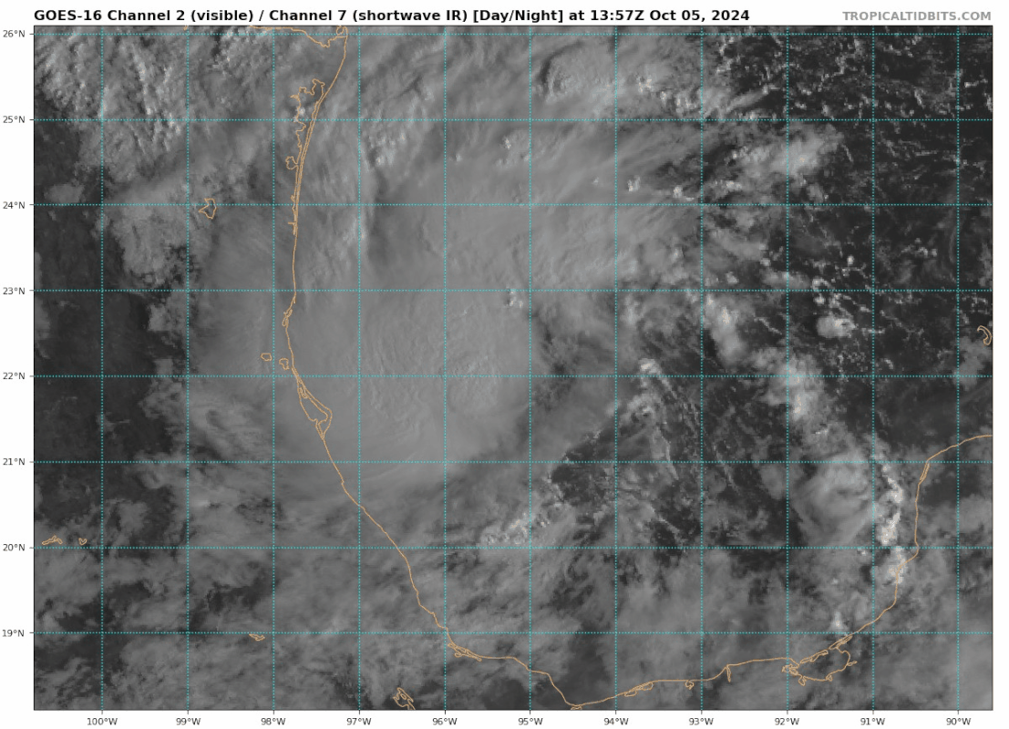
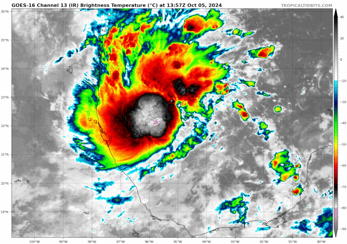
Teban54 wrote:Already looks like it's taking shape. Yikes.
https://i.postimg.cc/WzbPvNYX/goes16-vis-swir-14-L-202410051357.gif
https://i.postimg.cc/pTs6KDkJ/goes16-ir-14-L-202410051357.gif


zzzh wrote:Teban54 wrote:Already looks like it's taking shape. Yikes.
https://i.postimg.cc/WzbPvNYX/goes16-vis-swir-14-L-202410051357.gif
https://i.postimg.cc/pTs6KDkJ/goes16-ir-14-L-202410051357.gif
I think LLC is near the eastern edge of convection, need ascat/recon to see where the exact center is.
Users browsing this forum: No registered users and 85 guests


