
The lowest pressure found is 979.2 mb with 16 kt winds, which supports 978 - 979 mb, 10 - 11 mb lower than the current advisory.
This would mean an intensification rate of about 11 mb over the last 6 hours (the previous AF plane) so ~1.8 mb/hr. I think the actual intensification rate is even higher since it was probably holding steady the first few hours after recon left. Either way, Ernesto is really going for it now. Winds still have to get more symmetrical though as they were only 40 kt SFMR and 37 kt FL in the SW quadrant. Meanwhile the NE quadrant had 54 kt SFMR and 63 kt FL so far. I expect winds in the other quadrants to also quickly increase as Ernesto continues deepening.
ATL: ERNESTO - Post-Tropical - Discussion
Moderator: S2k Moderators
-
MarioProtVI
- Category 5

- Posts: 1039
- Age: 24
- Joined: Sun Sep 29, 2019 7:33 pm
- Location: New Jersey
Re: ATL: ERNESTO - Hurricane - Discussion
Hurricane2022 wrote:Extrap 979.2. But winds on the SE quad are still very weak
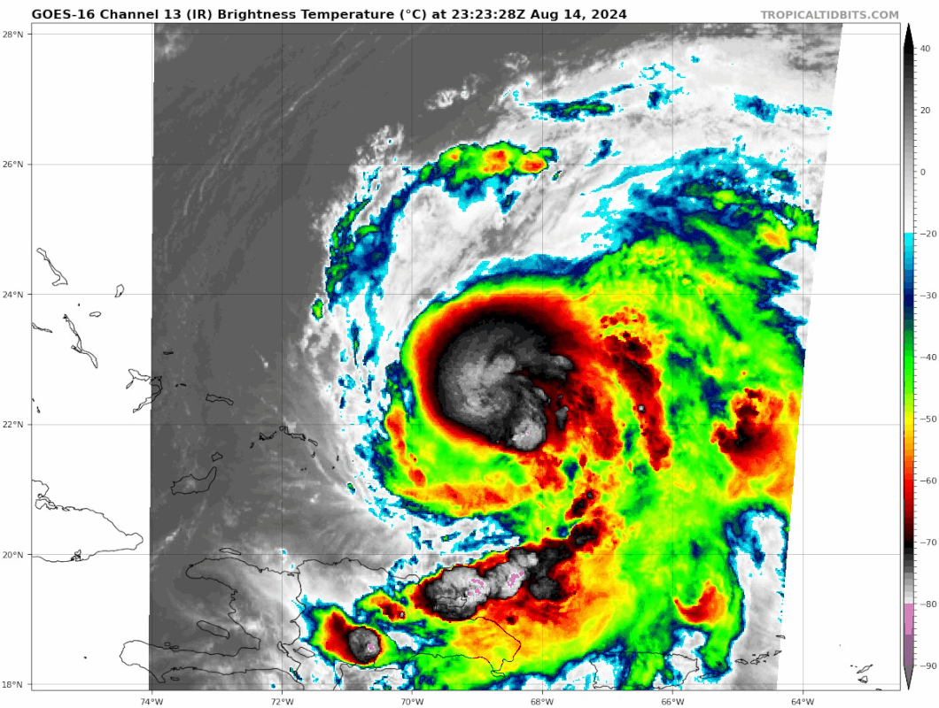
Based on microwave it seems the NW quad is the strongest. Let’s see what they find here. But I think the winds are currently lagging. Should pick up overnight.
1 likes

Re: ATL: ERNESTO - Hurricane - Discussion
It looks like while the central pressure has been dropping quite significantly that winds are still lagging. The highest SFMR readings are right at the core while the highest FL winds are further out, so I'd expect the wind field to tighten up over the next couple hours. This is about the time in development where I wish we had NOAA recon in-storm to get a vertical profile from the tail doppler.
0 likes
Re: ATL: ERNESTO - Hurricane - Discussion
VDM reports a 25nm circular eye open SW, which is consistent with the latest microwave imagery.
0 likes

Re: ATL: ERNESTO - Hurricane - Discussion
982/15 eye drop supports 980mb.
0 likes
Irene '11 Sandy '12 Hermine '16 5/15/2018 Derecho Fay '20 Isaias '20 Elsa '21 Henri '21 Ida '21
I am only a meteorology enthusiast who knows a decent amount about tropical cyclones. Look to the professional mets, the NHC, or your local weather office for the best information.
I am only a meteorology enthusiast who knows a decent amount about tropical cyclones. Look to the professional mets, the NHC, or your local weather office for the best information.
-
weeniepatrol

- Category 5
- Posts: 1345
- Joined: Sat Aug 22, 2020 5:30 pm
- Location: WA State
Re: ATL: ERNESTO - Hurricane - Discussion
Travorum wrote:VDM reports a 25nm circular eye open SW, which is consistent with the latest microwave imagery.

4 likes

Re: ATL: ERNESTO - Hurricane - Discussion
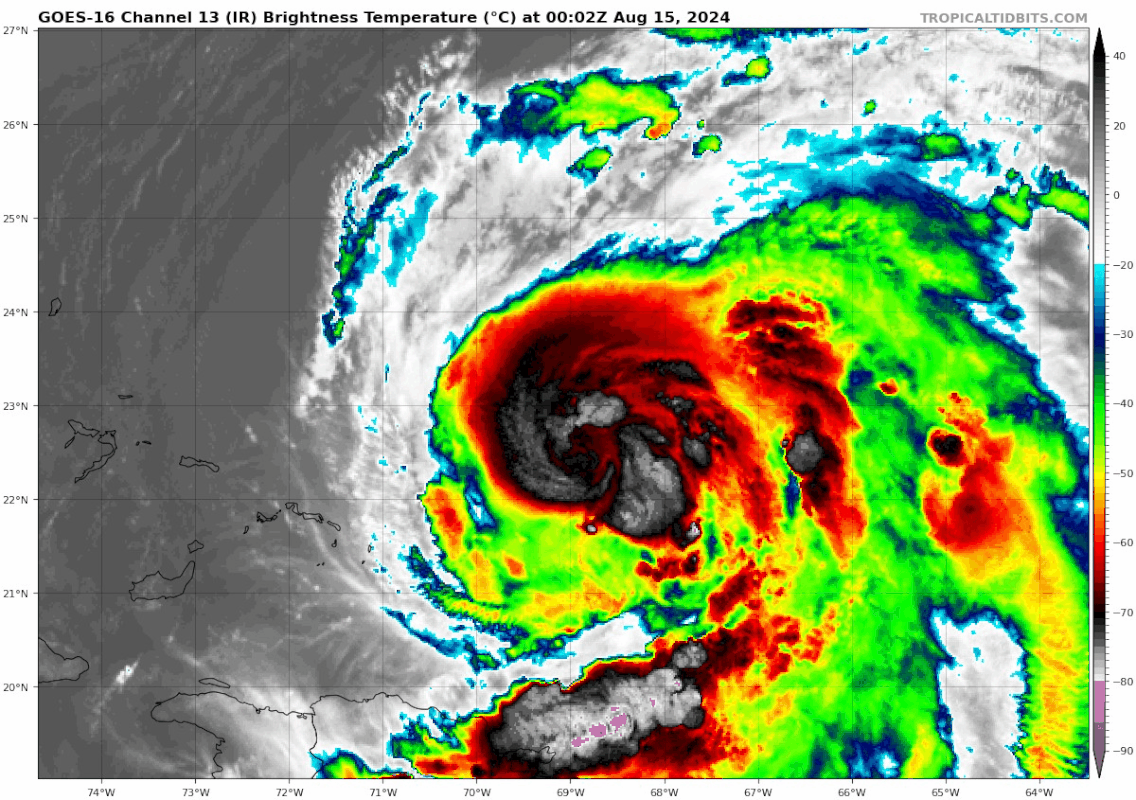
Eye popping up on IR as well:
1 likes
TC naming lists: retirements and intensity
Most aggressive Advisory #1's in North Atlantic (cr. kevin for starting the list)
Most aggressive Advisory #1's in North Atlantic (cr. kevin for starting the list)
-
Hypercane_Kyle

- Category 5
- Posts: 3465
- Joined: Sat Mar 07, 2015 7:58 pm
- Location: Cape Canaveral, FL
Re: ATL: ERNESTO - Hurricane - Discussion
Looking like a very healthy hurricane... my guess is 105-110 knot peak.

0 likes
My posts are my own personal opinion, defer to the National Hurricane Center (NHC) and other NOAA products for decision making during hurricane season.
-
cheezyWXguy

- Category 5
- Posts: 6282
- Joined: Mon Feb 13, 2006 12:29 am
- Location: Dallas, TX
Re: ATL: ERNESTO - Hurricane - Discussion
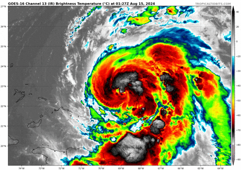
Inb4 the comments about cloud tops warming. This is common for hurricanes when they start clearing an eye.
4 likes
-
ElectricStorm

- Category 5
- Posts: 5153
- Age: 25
- Joined: Tue Aug 13, 2019 11:23 pm
- Location: Norman, OK
Re: ATL: ERNESTO - Hurricane - Discussion
05L ERNESTO 240815 0000 22.4N 68.7W ATL 70 981
0 likes
B.S Meteorology, University of Oklahoma '25
Please refer to the NHC, NWS, or SPC for official information.
Please refer to the NHC, NWS, or SPC for official information.
-
emeraldislenc
- Category 2

- Posts: 601
- Joined: Fri Aug 24, 2012 4:49 pm
- Location: Emerald Isle NC
Re: ATL: ERNESTO - Hurricane - Discussion
Let's speculate where Ernesto would have gone without the trough set up? Just curious.
0 likes
-
Sciencerocks
- Category 5
- Posts: 10193
- Age: 40
- Joined: Thu Jul 06, 2017 1:51 am

Re: ATL: ERNESTO - Hurricane - Discussion
1 likes
TC naming lists: retirements and intensity
Most aggressive Advisory #1's in North Atlantic (cr. kevin for starting the list)
Most aggressive Advisory #1's in North Atlantic (cr. kevin for starting the list)
-
REDHurricane

- Category 1

- Posts: 438
- Age: 28
- Joined: Sun Jul 03, 2022 2:36 pm
- Location: Northeast Pacific Ocean

-
HurricaneRyan
- Category 3

- Posts: 847
- Age: 32
- Joined: Sun Dec 05, 2010 3:05 pm
Re: ATL: ERNESTO - Hurricane - Discussion
The track and intensity of this storm reminds me of Dean 1989, which occurred around the same time of year just at the very beginning of August instead of the middle.
1 likes
Kay '22 Hilary '23
-
REDHurricane
- Category 1
- Posts: 438
- Age: 28
- Joined: Sun Jul 03, 2022 2:36 pm
- Location: Northeast Pacific Ocean

Re: ATL: ERNESTO - Hurricane - Discussion

Really starting to curl up, and probably going to have a fairly tight inner core at this rate
0 likes
The above post is not official and should not be used as such. It is the opinion of the poster and may or may not be backed by sound meteorological data. It is not endorsed by any professional institution or storm2k.org. For official information, please refer to the NHC and NWS products.
Re: ATL: ERNESTO - Hurricane - Discussion
A beautiful hurricane with very prominent spiral banding, I always like these. Reminds me a little bit of Epsilon 2020.
0 likes
-
REDHurricane
- Category 1
- Posts: 438
- Age: 28
- Joined: Sun Jul 03, 2022 2:36 pm
- Location: Northeast Pacific Ocean
Re: ATL: ERNESTO - Hurricane - Discussion
Hammy wrote:https://i.imgur.com/gSvbEin.png
Really starting to curl up, and probably going to have a fairly tight inner core at this rate
5 likes
Who is online
Users browsing this forum: No registered users and 73 guests