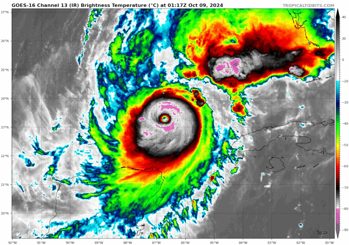
ATL: MILTON - Post-Tropical - Discussion

Moderator: S2k Moderators

Message
Author
User avatar
Hypercane_Kyle
Category 5
Category 5
Posts: 3354
Joined: Sat Mar 07, 2015 7:58 pm
Location: Cape Canaveral, FL

Re: ATL: MILTON - Hurricane - Discussion: 165 mph / 902 mbs

#3941 Postby Hypercane_Kyle » Tue Oct 08, 2024 9:31 pm


I've noticed Milton isn't really letting go of having a ton of lightning in its core. I wonder if the MSLP rise we are seeing is more-so due to expanding size as it interacts with the jet stream vs an EWRC. Visually it still looks impressive.
6 likes   
My posts are my own personal opinion, defer to the National Hurricane Center (NHC) and other NOAA products for decision making during hurricane season.

User avatar
eastcoastFL
Category 5
Category 5
Posts: 3901
Age: 43
Joined: Thu Apr 12, 2007 12:29 pm
Location: Palm City, FL

Re: ATL: MILTON - Hurricane - Discussion: 165 mph / 902 mbs

#3942 Postby eastcoastFL » Tue Oct 08, 2024 9:32 pm

gailwarning wrote:
tiger_deF wrote:The good news throughout this is that (even with the predicted expansion of wind radius) Milton is a small system. It could conceivably thread the needle between Sarasota and Fort Meyers, or maybe even Tampa and Sarasota. Of course all places would still receive hurricane force winds and potentially life threatening surge, but the damage corridor would be minimized.

A storm like Katrina at this heading would bring 20-30+ feet of surge over the entire region, and major hurricane impacts across the most populated corridor in Florida, and be a true catastrophe. Milton will be disastrous but more localized, like an Anti-Helene.


Will the EWRC that may be underway cause the size of the storm to increase?


It very well could. Will it? Nobody knows for sure.
2 likes   
Personal Forecast Disclaimer:
The posts in this forum are NOT official forecast and should not be used as such. They are just the opinion of the poster and may or may not be backed by sound meteorological data. They are NOT endorsed by any professional institution or storm2k.org. For official information, please refer to the NHC and NWS products.

Exalt
Category 1
Category 1
Posts: 337
Joined: Thu Nov 26, 2015 10:55 pm

Re: ATL: MILTON - Hurricane - Discussion: 165 mph / 902 mbs

#3943 Postby Exalt » Tue Oct 08, 2024 9:32 pm

tolakram wrote:I think Milton has gotten a bit smaller.

The full Milton
https://i.imgur.com/q2LB7qM.gif


Coastal interaction?
0 likes   

User avatar
Blown Away
S2K Supporter
S2K Supporter
Posts: 10152
Joined: Wed May 26, 2004 6:17 am

Re: ATL: MILTON - Hurricane - Discussion: 165 mph / 902 mbs

#3944 Postby Blown Away » Tue Oct 08, 2024 9:37 pm

Image

INIT 08/2100Z 22.7N 87.5W 145 KT 165 MPH
12H 09/0600Z 23.8N 86.4W 145 KT 165 MPH


Another E wobble, looks like Milton will be E of the 06z point…
3 likes   
Hurricane Eye Experience: David 79, Irene 99, Frances 04, Jeanne 04, Wilma 05... EYE COMING MY WAY IN 2024…
Hurricane Brush Experience: Andrew 92, Erin 95, Floyd 99, Matthew 16, Irma 17, Ian 22, Nicole 22…

psyclone
S2K Supporter
S2K Supporter
Posts: 4769
Joined: Wed Aug 24, 2005 9:04 pm
Location: palm harbor fl

Re: ATL: MILTON - Hurricane - Discussion: 165 mph / 902 mbs

#3945 Postby psyclone » Tue Oct 08, 2024 9:40 pm

It looks relentlessly eastbound. I'd expect the nhc to adjust south again...
1 likes   

User avatar
ElectricStorm
Category 5
Category 5
Posts: 5057
Age: 24
Joined: Tue Aug 13, 2019 11:23 pm
Location: Skiatook, OK / Norman, OK

Re: ATL: MILTON - Hurricane - Discussion: 165 mph / 902 mbs

#3946 Postby ElectricStorm » Tue Oct 08, 2024 9:42 pm

Hurricane Milton Advisory Number 16
NWS National Hurricane Center Miami FL AL142024
1000 PM CDT Tue Oct 08 2024

...MILTON EXPECTED TO MAKE LANDFALL ON THE GULF COAST OF FLORIDA
LATE WEDNESDAY AS A DANGEROUS MAJOR HURRICANE...


SUMMARY OF 1000 PM CDT...0300 UTC...INFORMATION
-----------------------------------------------
LOCATION...23.4N 86.5W
ABOUT 245 MI...395 KM WSW OF THE DRY TORTUGAS
ABOUT 405 MI...650 KM SW OF TAMPA FLORIDA
MAXIMUM SUSTAINED WINDS...160 MPH...260 KM/H
PRESENT MOVEMENT...NE OR 55 DEGREES AT 12 MPH...19 KM/H
MINIMUM CENTRAL PRESSURE...915 MB...27.02 INCHES
1 likes   
B.S Meteorology, University of Oklahoma '25

Please refer to the NHC, NWS, or SPC for official information.

User avatar
Stormgodess
Category 1
Category 1
Posts: 301
Joined: Mon Sep 14, 2020 1:31 am

Re: ATL: MILTON - Hurricane - Discussion: 165 mph / 902 mbs

#3947 Postby Stormgodess » Tue Oct 08, 2024 9:45 pm

tolakram wrote:saved loop
https://i.imgur.com/xecDWYh.gif


What is the blob that's been in front of Milton this whole time, and what effect does it have on the storm besides dropping plenty of rain prior to landfall?
4 likes   

caneseddy
Category 5
Category 5
Posts: 1172
Joined: Fri Sep 03, 2004 9:31 pm
Location: Plantation, FL

Re: ATL: MILTON - Hurricane - Discussion: 165 mph / 902 mbs

#3948 Postby caneseddy » Tue Oct 08, 2024 9:45 pm

The official track forecast is very similar to the previous one, and is generally a little north
of the model trackers, but follows the actual model predicted
cyclone center locations. This is close to a blend of the latest
GFS and ECMWF model solutions. Again, it is critical to remember
that even at 24 hours out, it is still not possible to pinpoint an
an exact landfall location

No change to the track and they are disregarding the model trackers that were showing further south so no all clear yet for Tampa.
Last edited by caneseddy on Tue Oct 08, 2024 9:52 pm, edited 4 times in total.
4 likes   

USTropics
Professional-Met
Professional-Met
Posts: 2659
Joined: Sun Aug 12, 2007 3:45 am
Location: Florida State University

Re: ATL: MILTON - Hurricane - Discussion: 165 mph / 902 mbs

#3949 Postby USTropics » Tue Oct 08, 2024 9:45 pm

eastcoastFL wrote:
gailwarning wrote:
tiger_deF wrote:The good news throughout this is that (even with the predicted expansion of wind radius) Milton is a small system. It could conceivably thread the needle between Sarasota and Fort Meyers, or maybe even Tampa and Sarasota. Of course all places would still receive hurricane force winds and potentially life threatening surge, but the damage corridor would be minimized.

A storm like Katrina at this heading would bring 20-30+ feet of surge over the entire region, and major hurricane impacts across the most populated corridor in Florida, and be a true catastrophe. Milton will be disastrous but more localized, like an Anti-Helene.


Will the EWRC that may be underway cause the size of the storm to increase?


It very well could. Will it? Nobody knows for sure.


While EWRC can increase the wind field, further contraction of the eye wall can also decrease the wind field. The HAFSB model has been performing the best in terms of intensity, and in the loop below you can see this cool interaction of the wind field expansion as Milton initially intensified a few days ago, wind field shrinks as the eye contracts, and then the wind field expands after the EWRC competes. We're seeing the same process here. The true wind field expansion will occur when Milton begins to interact with the trough axis more tomorrow (starting around 8am-2pm). All of the hurricane models have a significantly expanding wind field as it does this (the NHC is even expecting the wind field to more than double).

Image
2 likes   

NFLnut
Category 2
Category 2
Posts: 541
Joined: Sun Aug 29, 2004 7:37 pm

Re: ATL: MILTON - Hurricane - Discussion: 165 mph / 902 mbs

#3950 Postby NFLnut » Tue Oct 08, 2024 9:52 pm

dafif wrote:Can someone help me. I think on this site during Helene someone posted a link to a web page that showed the wind/projected wind for your location.

Does anyone remember or know that link? Thanks.


The one I use is at good ol' Weather.gov.

Once there, enter your zip code in the box to the upper left corner. Press GO. Once there, scroll 2/3's down and click on "Tabular Forecast." Pick the 48 hour period you're looking for. There you will find surface wind and gusts forecast. I have used this for years. It's usually pretty close although yesterday it showed 70--92--70 gusts over 3 hours. I think the 92 was an anomaly but it seems correct to me now.
2 likes   

FLLurker32
Tropical Storm
Tropical Storm
Posts: 245
Joined: Mon Aug 29, 2016 10:31 am

Re: ATL: MILTON - Hurricane - Discussion: 165 mph / 902 mbs

#3951 Postby FLLurker32 » Tue Oct 08, 2024 9:52 pm

Blown Away wrote:[url]https://i.postimg.cc/9QGGzxCq/goes16-ir-14-L-202410090117.gif [/url]

INIT 08/2100Z 22.7N 87.5W 145 KT 165 MPH
12H 09/0600Z 23.8N 86.4W 145 KT 165 MPH


Another E wobble, looks like Milton will be E of the 06z point…


Overall motion is still on track. It’s just a ton of energy navigating its NE turn.
0 likes   
Heather

psyclone
S2K Supporter
S2K Supporter
Posts: 4769
Joined: Wed Aug 24, 2005 9:04 pm
Location: palm harbor fl

Re: ATL: MILTON - Hurricane - Discussion

#3952 Postby psyclone » Tue Oct 08, 2024 9:52 pm

Hurricane wind odds in Tampa fell to 37% (still high but a big drop) while hurricane wind odds in Venice rose to an astounding 67%. My goodness brace for impact down that way...!
2 likes   

User avatar
CronkPSU
S2K Supporter
S2K Supporter
Posts: 2014
Joined: Sun Aug 07, 2005 10:44 pm
Location: Avalon Park, FL

Re: ATL: MILTON - Hurricane - Discussion

#3953 Postby CronkPSU » Tue Oct 08, 2024 9:54 pm

Second discussion in a row talking about an extratropical transition near landfall…can anyone give an explanation of how that affects the impact of the storm? I see the NHC is no longer keeping it a cat 2 near Orlando
1 likes   
Just like Jon Snow..."I know nothing" except what I know, and most of what I know is gathered by the fine people of the NHC

Mike33534
Tropical Low
Tropical Low
Posts: 28
Joined: Tue Oct 08, 2024 12:17 am

Re: ATL: MILTON - Hurricane - Discussion: 165 mph / 902 mbs

#3954 Postby Mike33534 » Tue Oct 08, 2024 9:54 pm

caneseddy wrote:The official track forecast is very similar to the previous one, and is generally a little north
of the model trackers, but follows the actual model predicted
cyclone center locations. This is close to a blend of the latest
GFS and ECMWF model solutions. Again, it is critical to remember
that even at 24 hours out, it is still not possible to pinpoint an
an exact landfall location

No change to the track and they are disregarding the model trackers that were showing further south so no all clear yet for Tampa.

Seems like they are hedging on the side of caution in case of something unexpected happening
0 likes   

User avatar
johngaltfla
Category 5
Category 5
Posts: 2069
Joined: Sun Jul 10, 2005 9:17 pm
Location: Sarasota County, FL
Contact:

Re: ATL: MILTON - Hurricane - Discussion

#3955 Postby johngaltfla » Tue Oct 08, 2024 9:55 pm

psyclone wrote:Hurricane wind odds in Tampa fell to 37% (still high but a big drop) while hurricane wind odds in Venice rose to an astounding 67%. My goodness brace for impact down that way...!


Potential paths are close to my house down here on the south side of Sarasota.

Tomorrow night will not be dull.
4 likes   

psyclone
S2K Supporter
S2K Supporter
Posts: 4769
Joined: Wed Aug 24, 2005 9:04 pm
Location: palm harbor fl

Re: ATL: MILTON - Hurricane - Discussion

#3956 Postby psyclone » Tue Oct 08, 2024 9:58 pm

The very heavy rain modeled on the north side of this storm is slated to hammer the tampa bay and Orlando regions. Unless the storm angles farther south those areas still going to take a beating. Ian had that heavy convection weighted northwest as well.
2 likes   

User avatar
ColdFusion
S2K Supporter
S2K Supporter
Posts: 443
Joined: Wed Feb 13, 2008 3:46 pm
Location: Addison, TX

Re: ATL: MILTON - Hurricane - Discussion

#3957 Postby ColdFusion » Tue Oct 08, 2024 9:59 pm

johngaltfla wrote:
psyclone wrote:Hurricane wind odds in Tampa fell to 37% (still high but a big drop) while hurricane wind odds in Venice rose to an astounding 67%. My goodness brace for impact down that way...!


Potential paths are close to my house down here on the south side of Sarasota.

Tomorrow night will not be dull.


Wait, so are you saying there's a 63% chance Tampa doesn't even get Hurricane strength winds now? Wow.
0 likes   

USTropics
Professional-Met
Professional-Met
Posts: 2659
Joined: Sun Aug 12, 2007 3:45 am
Location: Florida State University

Re: ATL: MILTON - Hurricane - Discussion

#3958 Postby USTropics » Tue Oct 08, 2024 9:59 pm

CronkPSU wrote:Second discussion in a row talking about an extratropical transition near landfall…can anyone give an explanation of how that affects the impact of the storm? I see the NHC is no longer keeping it a cat 2 near Orlando


See my post above on wind field expansion, that is the biggest. Basically a significant front is pushing down (may get dewpoints in the 30s here in Tally). Milton will begin to feel those baroclinic influences (lots of dry, stable air behind the cold front). Essentially, it's transition from a warm core, tropical cyclone to more of a cold core, mid-latitude/extratropical cyclone will be quick:

Image
Last edited by USTropics on Tue Oct 08, 2024 10:04 pm, edited 1 time in total.
2 likes   

User avatar
NDG
S2K Supporter
S2K Supporter
Posts: 15448
Joined: Sun Jul 09, 2006 10:14 pm
Location: Orlando, FL

Re: ATL: MILTON - Hurricane - Discussion

#3959 Postby NDG » Tue Oct 08, 2024 10:00 pm

Glad the latest NHC forecast track is a blend of the GFS and Euro, what I have been preaching all the time.

The official track forecast
is very similar to the previous one, and is generally a little north
of the model trackers, but follows the actual model predicted
cyclone center locations. This is close to a blend of the latest
GFS and ECMWF model solutions. Again, it is critical to remember
that even at 24 hours out, it is still not possible to pinpoint an
an exact landfall location.
Last edited by NDG on Tue Oct 08, 2024 10:03 pm, edited 1 time in total.
2 likes   

psyclone
S2K Supporter
S2K Supporter
Posts: 4769
Joined: Wed Aug 24, 2005 9:04 pm
Location: palm harbor fl

Re: ATL: MILTON - Hurricane - Discussion

#3960 Postby psyclone » Tue Oct 08, 2024 10:02 pm

ColdFusion wrote:
johngaltfla wrote:
psyclone wrote:Hurricane wind odds in Tampa fell to 37% (still high but a big drop) while hurricane wind odds in Venice rose to an astounding 67%. My goodness brace for impact down that way...!


Potential paths are close to my house down here on the south side of Sarasota.

Tomorrow night will not be dull.


Wait, so are you saying there's a 63% chance Tampa doesn't even get Hurricane strength winds now? Wow.

That's actually a very high number. I follow the probability tables closely...a third is alot and two thirds is very high. Tampa peaked at 50% IIRC so we are dropping nicely
1 likes   


Return to “2024”

Who is online

Users browsing this forum: No registered users and 5 guests