
I can only assume it's just a mid-level circulation of some sort and that's why the NHC hasn't mentioned it in any of their products (well, not to my knowledge anyway). Could a promet please weigh in?chaser1 wrote:Blinhart wrote:ChrisH-UK wrote:The problem is with 92L is that it is a 3 or even 4 bodied problem. The models have it emerging for these waves and another wave coming off the coast of Africa it's this that is causing a problem with the models and the on off nature of them, there figuring out which one has the dominance to form in to a storm or two.
[url]https://imagizer.imageshack.com/img924/1919/TYwQDa.gif [/url]
I could see 2 or 3 different systems to come out of this mess.
Perhaps. In any other year I'd say probable. In fact, while all the chatter is over 92L and the wave further east.... I'm more focused on the ITCZ disturbance at 12N and 52W! I see some level of rotation to it right now.
ATL: INVEST 92L - Discussion
Moderator: S2k Moderators
Re: ATL: INVEST 92L - Discussion
0 likes

Re: ATL: INVEST 92L - Discussion
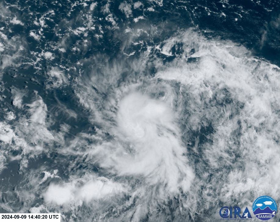
Meanwhile, while I don't want to start a new thread, a feature to the west at 52W is also looking interesting. It has the most clearly defined LLC in the entire MDR now (and possibly in the entire basin as of 2 hours ago), albeit also the most naked. Earlier today (not in this loop), it produced a nice burst of convection that started rotating, although that has since poofed.
Models generally don't organize it much further, and merge it (or Fujiwhara) with 92L later. That said, models are also playing catch-up with this disturbance. I'm showing Euro here because its catchup is the most drastic, but that also applies to other models.
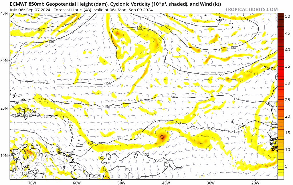
Models generally don't organize it much further, and merge it (or Fujiwhara) with 92L later. That said, models are also playing catch-up with this disturbance. I'm showing Euro here because its catchup is the most drastic, but that also applies to other models.
3 likes
TC naming lists: retirements and intensity
Most aggressive Advisory #1's in North Atlantic (cr. kevin for starting the list)
Most aggressive Advisory #1's in North Atlantic (cr. kevin for starting the list)
Re: ATL: INVEST 92L - Discussion
Still 60/60, but the cone of possible development has shrunk.
1. Central Tropical Atlantic (AL92):
An elongated area of low pressure over the central tropical
Atlantic continues to produce disorganized showers and
thunderstorms. Environmental conditions are marginally conducive
for development during the next few days, and a tropical depression
could form while the system meanders over the central tropical
Atlantic. By the middle part of the week, the system is forecast
to move west-northwestward at around 10 mph.
* Formation chance through 48 hours...medium...60 percent.
* Formation chance through 7 days...medium...60 percent.
0 likes
TC naming lists: retirements and intensity
Most aggressive Advisory #1's in North Atlantic (cr. kevin for starting the list)
Most aggressive Advisory #1's in North Atlantic (cr. kevin for starting the list)
-
Cachondo23
- Tropical Storm

- Posts: 131
- Joined: Wed May 25, 2022 5:56 am
Re: ATL: INVEST 92L - Discussion
Down to 40/40.
1. Central Tropical Atlantic (AL92):
An elongated area of low pressure over the central tropical
Atlantic is producing limited shower activity. Environmental
conditions appear only marginally conducive for some slight
development during the next couple of days, but a tropical
depression could still form during that time while the system
meanders over the central tropical Atlantic.
* Formation chance through 48 hours...medium...40 percent.
* Formation chance through 7 days...medium...40 percent.
1 likes
TC naming lists: retirements and intensity
Most aggressive Advisory #1's in North Atlantic (cr. kevin for starting the list)
Most aggressive Advisory #1's in North Atlantic (cr. kevin for starting the list)

Re: ATL: INVEST 92L - Discussion
Tomorrow is the most likely window for development. Environment is marginal but it would only take ~12 hours of sustained deep convection for a TC here given the circulation is already basically present.
0 likes
Kendall -> SLO -> PBC
Memorable Storms: Katrina (for its Florida landfall...) Wilma Matthew Irma
Memorable Storms: Katrina (for its Florida landfall...) Wilma Matthew Irma
Re: ATL: INVEST 92L - Discussion
Ubuntwo wrote:Tomorrow is the most likely window for development. Environment is marginal but it would only take ~12 hours of sustained deep convection for a TC here given the circulation is already basically present.
Of course, the other risk is that it may not be officially acknowledged due to being expected to be a shortie, even if convection does fire for 12 hours.
0 likes
TC naming lists: retirements and intensity
Most aggressive Advisory #1's in North Atlantic (cr. kevin for starting the list)
Most aggressive Advisory #1's in North Atlantic (cr. kevin for starting the list)
Re: ATL: INVEST 92L - Discussion
Teban54 wrote:Ubuntwo wrote:Tomorrow is the most likely window for development. Environment is marginal but it would only take ~12 hours of sustained deep convection for a TC here given the circulation is already basically present.
Of course, the other risk is that it may not be officially acknowledged due to being expected to be a shortie, even if convection does fire for 12 hours.
Agreed... though they are already at medium. Can very easily jump to high and then TD in a 3-hour window.
0 likes
Kendall -> SLO -> PBC
Memorable Storms: Katrina (for its Florida landfall...) Wilma Matthew Irma
Memorable Storms: Katrina (for its Florida landfall...) Wilma Matthew Irma
Re: ATL: INVEST 92L - Discussion
Hmm...
1 likes
TC naming lists: retirements and intensity
Most aggressive Advisory #1's in North Atlantic (cr. kevin for starting the list)
Most aggressive Advisory #1's in North Atlantic (cr. kevin for starting the list)
Re: ATL: INVEST 92L - Discussion
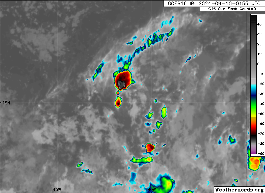
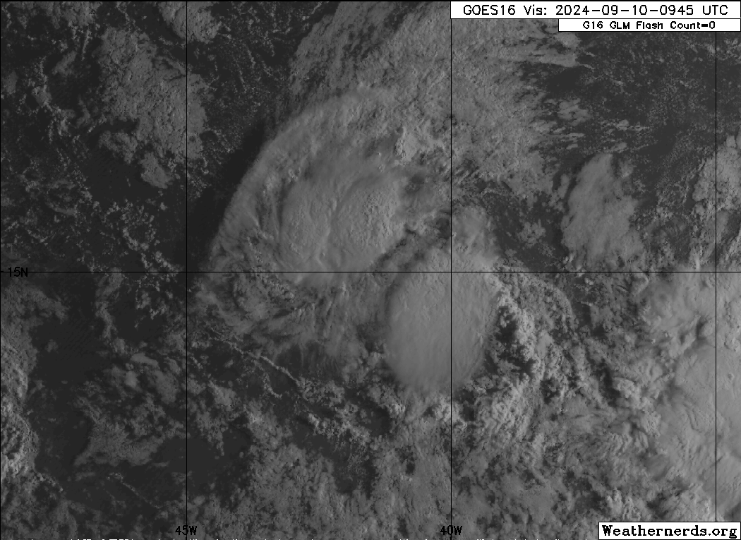
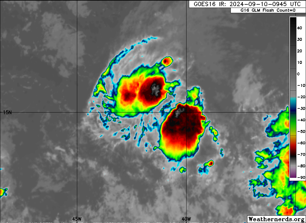
Plenty of convection going on in the waves and the shear is low in the area looking like it's in a good state to develop.

1 likes
Re: ATL: INVEST 92L - Discussion
Convection has sustained for several hours now, even if somewhat pulsing. I can't easily see what's at the surface, however.
0 likes
TC naming lists: retirements and intensity
Most aggressive Advisory #1's in North Atlantic (cr. kevin for starting the list)
Most aggressive Advisory #1's in North Atlantic (cr. kevin for starting the list)
-
AnnularCane

- S2K Supporter

- Posts: 2957
- Joined: Thu Jun 08, 2006 9:18 am
- Location: Wytheville, VA
Re: ATL: INVEST 92L - Discussion
Looks like it's being slowly engulfed by the big red thing on the TWO. 
0 likes
"But it never rained rain. It never snowed snow. And it never blew just wind. It rained things like soup and juice. It snowed mashed potatoes and green peas. And sometimes the wind blew in storms of hamburgers." -- Judi Barrett, Cloudy with a Chance of Meatballs
-
Sciencerocks
- Category 5

- Posts: 10181
- Age: 40
- Joined: Thu Jul 06, 2017 1:51 am

Re: ATL: INVEST 92L - Discussion
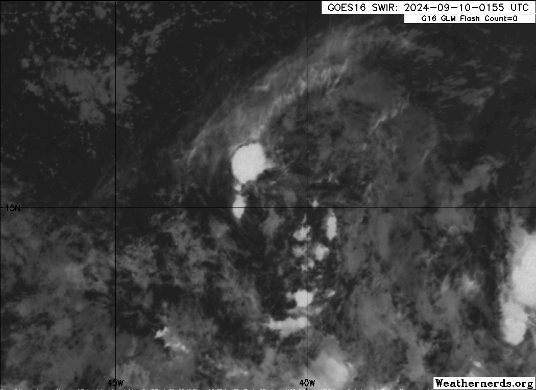
The 2 cute little storms of 92L running away from the big bad storm that will be coming for them.

1 likes
-
Sciencerocks
- Category 5
- Posts: 10181
- Age: 40
- Joined: Thu Jul 06, 2017 1:51 am
Re: ATL: INVEST 92L - Discussion
ChrisH-UK wrote:The 2 cute little storms of 92L running away from the big bad storm that will be coming for them.
[url]https://imagizer.imageshack.com/img923/2515/mcWbsW.gif [/url]
They both look to be depressions or borderline tropical storms.
1 likes
-
WaveBreaking

- Category 2

- Posts: 717
- Joined: Sun Jun 30, 2024 11:33 am
- Location: US
Re: ATL: INVEST 92L - Discussion
Dropped to 40/40 30/30
Central Tropical Atlantic (AL92):
An elongated area of low pressure located over the central tropical
Atlantic continues to produce some disorganized shower and
thunderstorm activity. Environmental conditions appear only
marginally conducive for some slight development during the next
couple of days, but a tropical depression could still form during
that time while the system moves westward at 5 to 10 mph over the
central tropical Atlantic.
* Formation chance through 48 hours...low...30 percent.
* Formation chance through 7 days...low...30 percent.
Last edited by WaveBreaking on Tue Sep 10, 2024 1:04 pm, edited 1 time in total.
0 likes
I am NOT a professional meteorologist, so take all of my posts with a grain of salt. My opinions are mine and mine alone.
-
cycloneye

- Admin

- Posts: 149261
- Age: 69
- Joined: Thu Oct 10, 2002 10:54 am
- Location: San Juan, Puerto Rico
Re: ATL: INVEST 92L - Discussion
Down to 30/30.
Central Tropical Atlantic (AL92):
An elongated area of low pressure located over the central tropical
Atlantic continues to produce some disorganized shower and
thunderstorm activity. Environmental conditions appear only
marginally conducive for some slight development during the next
couple of days, but a tropical depression could still form during
that time while the system moves westward at 5 to 10 mph over the
central tropical Atlantic.
* Formation chance through 48 hours...low...30 percent.
* Formation chance through 7 days...low...30 percent.
An elongated area of low pressure located over the central tropical
Atlantic continues to produce some disorganized shower and
thunderstorm activity. Environmental conditions appear only
marginally conducive for some slight development during the next
couple of days, but a tropical depression could still form during
that time while the system moves westward at 5 to 10 mph over the
central tropical Atlantic.
* Formation chance through 48 hours...low...30 percent.
* Formation chance through 7 days...low...30 percent.
0 likes
Visit the Caribbean-Central America Weather Thread where you can find at first post web cams,radars
and observations from Caribbean basin members Click Here
and observations from Caribbean basin members Click Here
Re: ATL: INVEST 92L - Discussion
Sciencerocks wrote:ChrisH-UK wrote:The 2 cute little storms of 92L running away from the big bad storm that will be coming for them.
[url]https://imagizer.imageshack.com/img923/2515/mcWbsW.gif [/url]
They both look to be depressions or borderline tropical storms.
Their barely swirls in the sea.
0 likes

Re: ATL: INVEST 92L - Discussion
ChrisH-UK wrote:Sciencerocks wrote:ChrisH-UK wrote:The 2 cute little storms of 92L running away from the big bad storm that will be coming for them.
[url]https://imagizer.imageshack.com/img923/2515/mcWbsW.gif [/url]
They both look to be depressions or borderline tropical storms.
Their barely swirls in the sea.
Both easily fit depression criteria, close circulation with convection near the center, and having 25-30kt winds


2 likes
The above post is not official and should not be used as such. It is the opinion of the poster and may or may not be backed by sound meteorological data. It is not endorsed by any professional institution or storm2k.org. For official information, please refer to the NHC and NWS products.
Re: ATL: INVEST 92L - Discussion
92L is looking better with more convection and growing in size, hopefully it won't be consumed up by 93L.
Source GOES16 GeoProxy + Clean IR - https://col.st/V4C6x

Source GOES16 GeoProxy + Clean IR - https://col.st/V4C6x
0 likes
Who is online
Users browsing this forum: No registered users and 35 guests