
ATL: DEBBY - Models
Moderator: S2k Moderators
Re: ATL: INVEST 97L - Models
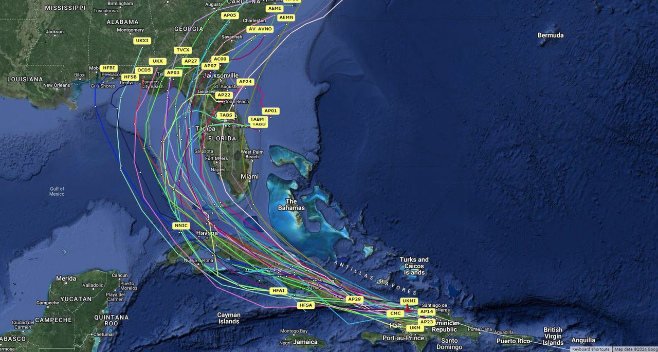
GEFS ensembles animated to follow the lows better in the squished spider look. Crazies run is the one that goes out to the Atlantic loops back and crosses Central Florida then into the Gulf and finally to Houston.
Last edited by BobHarlem on Thu Aug 01, 2024 3:17 pm, edited 2 times in total.
1 likes
-
Hurrilurker

- Category 2

- Posts: 738
- Joined: Mon Jun 09, 2003 3:32 pm
- Location: San Francisco, CA
Re: ATL: INVEST 97L - Models
The 977 heading west towards Houston is a bit scary, but it's an outlier.
0 likes
-
DunedinDave
- Category 1

- Posts: 269
- Joined: Fri Aug 25, 2023 10:31 am
Re: ATL: INVEST 97L - Models
BIFF_THE_UNRULY wrote:
The spaghetti's not looking good for Venice /Tampa/ Iveneress. I know we are still aways away but hold your breathe on intensity here
I am more nervous about the amount of rainfall we are going to get from this. I don’t think it will be anything to worry about wind-wise, but the Tampa area could get crushed with rain if it slowly skirts along the west coast and then maybe even comes back in a loopity-loop.
0 likes
Re: ATL: INVEST 97L - Models
Hurrilurker wrote:The 977 heading west towards Houston is a bit scary, but it's an outlier.
Very unlikely but it is one model run output. There are more aimed generally towards the AL/Miss/LA coast lines.
0 likes

Re: ATL: INVEST 97L - Models
12Z HMON had the worst track, finds the keys to the M.G. and tracks over water all the way to NOLA.
0 likes
Re: ATL: INVEST 97L - Models
18Z ICON landfall as a TS in the Big Bend of Florida. Stalls just off the coast of GA/SC.

1 likes
-
StPeteMike

- Category 2
- Posts: 657
- Joined: Thu Jun 07, 2018 11:26 pm
Re: ATL: INVEST 97L - Models
Hoping the intensity is correct, we saw how off they were with Beryl.
1 likes
The above post is not official and should not be used as such. It is the opinion of the poster and may or may not be backed by sound meteorological data. It is not endorsed by any professional institution or storm2k.org. For official information, please refer to the NHC and NWS products.
-
SouthFLTropics

- Category 5

- Posts: 4258
- Age: 50
- Joined: Thu Aug 14, 2003 8:04 am
- Location: Port St. Lucie, Florida
Re: ATL: INVEST 97L - Models
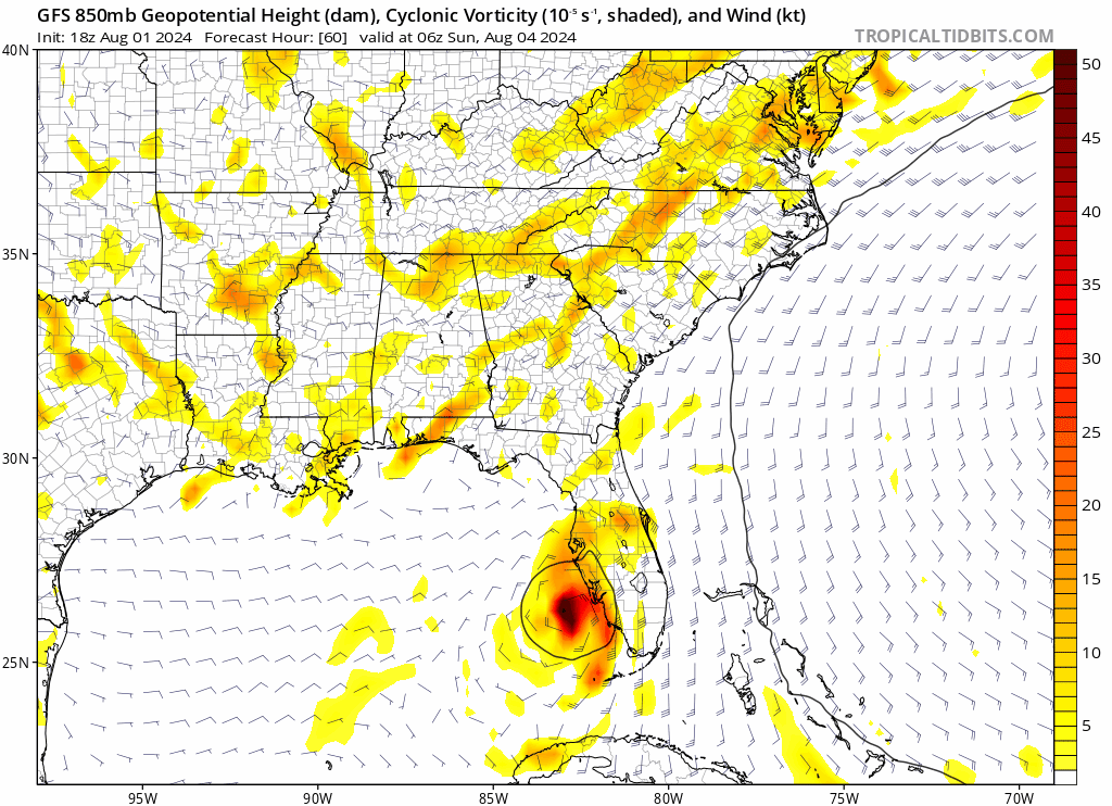
18z GFS coming in... looks like it makes landfall near Sarasota. Much further south and east of 12z.
0 likes
Fourth Generation Florida Native
Personal Storm History: David 79, Andrew 92, Erin 95, Floyd 99, Irene 99, Frances 04, Jeanne 04, Wilma 05, Matthew 16, Irma 17, Ian 22, Nicole 22, Milton 24
Personal Storm History: David 79, Andrew 92, Erin 95, Floyd 99, Irene 99, Frances 04, Jeanne 04, Wilma 05, Matthew 16, Irma 17, Ian 22, Nicole 22, Milton 24
Re: ATL: INVEST 97L - Models
18Z GFS through 96 hours. Nearly 200 miles ENE of the 12Z run so far.

Begins to stall after day 4.

Begins to stall after day 4.
Last edited by IcyTundra on Thu Aug 01, 2024 5:14 pm, edited 1 time in total.
0 likes
-
DunedinDave
- Category 1
- Posts: 269
- Joined: Fri Aug 25, 2023 10:31 am
Re: ATL: INVEST 97L - Models
IcyTundra wrote:18Z GFS through 96 hours. Nearly 200 miles ENE of the 12Z run so far.
https://i.ibb.co/R2yZW8q/gfs-mslp-pcpn-watl-fh6-96.gif
That’s better news for Tampa area. Seems to move in and out quick and is just mostly a rainmaker as opposed to stalling out along the coast. Hopefully it then moves out to sea.
0 likes
Re: ATL: INVEST 97L - Models
DunedinDave wrote:IcyTundra wrote:18Z GFS through 96 hours. Nearly 200 miles ENE of the 12Z run so far.
https://i.ibb.co/R2yZW8q/gfs-mslp-pcpn-watl-fh6-96.gif
That’s better news for Tampa area. Seems to move in and out quick and is just mostly a rainmaker as opposed to stalling out along the coast. Hopefully it then moves out to sea.
Let's hope models continue to trend this way. Lots of time for things to change still so we will keep wathcing.
0 likes
-
Stratton23
- Category 5
- Posts: 3575
- Joined: Fri Jul 21, 2023 10:59 pm
- Location: Katy, Tx
Re: ATL: INVEST 97L - Models
The GFS is betting on the northern Lobe becoming dominant and going to the north of cuba, looking at live imagery, most of the deep convection is south of the islands, I think the southern lobe will take over, i have more of a southern track before clipping western cuba and then turning north towards the florida peninsula, I think the GFS is a little too far to the north
1 likes
Re: ATL: INVEST 97L - Models
After it meanders in the Atlantic for a few days it bends back west and landfalls near Wilmington, NC.

18z GEFS mean shifted right also.
18z GEFS mean shifted right also.
Last edited by BobHarlem on Thu Aug 01, 2024 5:41 pm, edited 1 time in total.
0 likes

Re: ATL: INVEST 97L - Models
GFS continues to trend toward a weak system crossing Florida and stalling out over the Gulf Stream near GA/SC as a hurricane. Kinda reminds me of Chris ‘18.
0 likes
Irene '11 Sandy '12 Hermine '16 5/15/2018 Derecho Fay '20 Isaias '20 Elsa '21 Henri '21 Ida '21
I am only a meteorology enthusiast who knows a decent amount about tropical cyclones. Look to the professional mets, the NHC, or your local weather office for the best information.
I am only a meteorology enthusiast who knows a decent amount about tropical cyclones. Look to the professional mets, the NHC, or your local weather office for the best information.
-
Stratton23
- Category 5
- Posts: 3575
- Joined: Fri Jul 21, 2023 10:59 pm
- Location: Katy, Tx
Re: ATL: INVEST 97L - Models
18z GEFS, has two camps, one group goes up the east coast and stalls off NC, the other camp ends up getting pushed back innto the gulf again
0 likes
-
otowntiger
- Category 5
- Posts: 1932
- Joined: Tue Aug 31, 2004 7:06 pm
Re: ATL: INVEST 97L - Models
SouthFLTropics wrote:18z GFS coming in... looks like it makes landfall near Sarasota. Much further south and east of 12z.
Yes, but also much weaker and no stall. That would not be a terrible solution
0 likes
Re: ATL: INVEST 97L - Models
otowntiger wrote:SouthFLTropics wrote:18z GFS coming in... looks like it makes landfall near Sarasota. Much further south and east of 12z.
Yes, but also much weaker and no stall. That would not be a terrible solution
It would be good for Florida not so much for NC.
1 likes
-
Stratton23
- Category 5
- Posts: 3575
- Joined: Fri Jul 21, 2023 10:59 pm
- Location: Katy, Tx
Re: ATL: INVEST 97L - Models
yeah the GEFS still shows that their is plenty of uncertainty still, with a 2nd group of members getting pushed back into the gulf due to the bermuda high nosing in more, tough call
1 likes
-
SFLcane

- S2K Supporter

- Posts: 10281
- Age: 48
- Joined: Sat Jun 05, 2010 1:44 pm
- Location: Lake Worth Florida
Re: ATL: INVEST 97L - Models
Hmm that’s pretty far south could certainly mean more flooding potentially for SFL.
0 likes
-
jlauderdal
- S2K Supporter
- Posts: 7240
- Joined: Wed May 19, 2004 5:46 am
- Location: NE Fort Lauderdale
- Contact:
Re: RE: Re: ATL: INVEST 97L - Models
Ian victms dont want to see anything like that in the area.SFLcane wrote:Hmm that’s pretty far south could certainly mean more flooding potentially for SFL.
0 likes
Who is online
Users browsing this forum: No registered users and 38 guests