Another year, another powerhouse, memorable, and unfortunately likely-destructive Atlantic hurricane.
2025 was all fish storms and fun & games, until it wasn't. It really does only take one storm to define a season.
NATL: MELISSA - Aftermath - Discussion
Moderator: S2k Moderators
-
Category5Kaiju

- Category 5

- Posts: 4346
- Joined: Thu Dec 24, 2020 12:45 pm
- Location: Seattle during the summer, Phoenix during the winter
Re: NATL: MELISSA - Hurricane - Discussion
16 likes
Unless explicitly stated, all information in my posts is based on my own opinions and observations. Tropical storms and hurricanes can be extremely dangerous. Refer to an accredited weather research agency or meteorologist if you need to make serious decisions regarding an approaching storm.

-
Iceresistance

- Category 5
- Posts: 9606
- Age: 22
- Joined: Sat Oct 10, 2020 9:45 am
- Location: Tecumseh, OK/Norman, OK
Re: NATL: MELISSA - Hurricane - Discussion
4 likes
Bill 2015 & Beta 2020
Winter 2020-2021
All observations are in Tecumseh, OK unless otherwise noted.
Winter posts are focused mainly for Oklahoma & Texas.
Take any of my forecasts with a grain of salt, refer to the NWS, SPC, and NHC for official information
Never say Never with weather! Because ANYTHING is possible!
Winter 2020-2021
All observations are in Tecumseh, OK unless otherwise noted.
Winter posts are focused mainly for Oklahoma & Texas.
Take any of my forecasts with a grain of salt, refer to the NWS, SPC, and NHC for official information
Never say Never with weather! Because ANYTHING is possible!
-
Hurricane2022

- Category 5
- Posts: 2092
- Joined: Tue Aug 23, 2022 11:38 pm
- Location: Araçatuba, Brazil
Re: NATL: MELISSA - Hurricane - Discussion
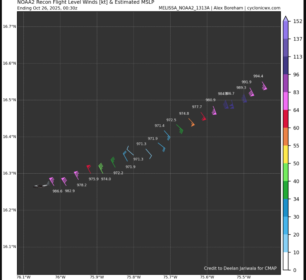
Iceresistance wrote:NOAA2 just had a 100 knot flight level wind
https://s12.gifyu.com/images/b3ncP.png
https://s12.gifyu.com/images/b3ncP.png
And no pressure drop at all (?)
0 likes
Sorry for the bad English sometimes...!
For reliable and detailed information for any meteorological phenomenon, please consult the National Hurricane Center, Joint Typhoon Warning Center , or your local Meteo Center.
--------
ECCE OMNIA NOVA FACIAM (Ap 21,5).
For reliable and detailed information for any meteorological phenomenon, please consult the National Hurricane Center, Joint Typhoon Warning Center , or your local Meteo Center.
--------
ECCE OMNIA NOVA FACIAM (Ap 21,5).
-
KirbyDude25

- Tropical Storm

- Posts: 162
- Age: 21
- Joined: Mon Sep 20, 2021 8:03 am
- Location: Westfield, New Jersey
Re: NATL: MELISSA - Hurricane - Discussion
Iceresistance wrote:NOAA2 just had a 100 knot flight level wind
https://s12.gifyu.com/images/b3ncP.png
https://s12.gifyu.com/images/b3ncP.png
No drop in extrapolated pressure, though. We'll have to wait for the dropsonde, of course, but it seems strange that the pressure hasn't dropped despite Melissa's improved appearance
1 likes
New Jersey, Rutgers '27
Irene 2011 | Sandy 2012 | Fay 2020 | Isaias 2020 | Ida 2021
Irene 2011 | Sandy 2012 | Fay 2020 | Isaias 2020 | Ida 2021
-
Iceresistance
- Category 5
- Posts: 9606
- Age: 22
- Joined: Sat Oct 10, 2020 9:45 am
- Location: Tecumseh, OK/Norman, OK
Re: NATL: MELISSA - Hurricane - Discussion
Hurricane2022 wrote:Iceresistance wrote:NOAA2 just had a 100 knot flight level wind
https://s12.gifyu.com/images/b3ncP.png
https://s12.gifyu.com/images/b3ncP.png
And no pressure drop at all (?)
Eye drop just came in
https://s12.gifyu.com/images/b3ngM.png
Seems like it's working out on finalizing the structure before it starts to bomb out
6 likes
Bill 2015 & Beta 2020
Winter 2020-2021
All observations are in Tecumseh, OK unless otherwise noted.
Winter posts are focused mainly for Oklahoma & Texas.
Take any of my forecasts with a grain of salt, refer to the NWS, SPC, and NHC for official information
Never say Never with weather! Because ANYTHING is possible!
Winter 2020-2021
All observations are in Tecumseh, OK unless otherwise noted.
Winter posts are focused mainly for Oklahoma & Texas.
Take any of my forecasts with a grain of salt, refer to the NWS, SPC, and NHC for official information
Never say Never with weather! Because ANYTHING is possible!

Re: NATL: MELISSA - Hurricane - Discussion
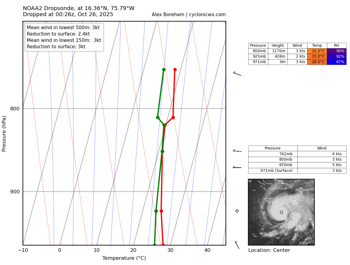
The dropsonde came in at 971mb w/3kts wind, so roughly steady since the last pass interestingly. Also of note that based on the two NOAA passes Melissa seems to be moving SW.
1 likes
-
WaveBreaking

- Category 2

- Posts: 728
- Joined: Sun Jun 30, 2024 11:33 am
- Location: US
Re: NATL: MELISSA - Hurricane - Discussion

4 likes
I am NOT a professional meteorologist, so take all of my posts with a grain of salt. My opinions are mine and mine alone.
-
Blown Away

- S2K Supporter

- Posts: 10253
- Joined: Wed May 26, 2004 6:17 am
Re: NATL: MELISSA - Hurricane - Discussion
8:00 PM EDT Sat Oct 25
Location: 16.5°N 75.6°W
Moving: W at 3 mph
Min pressure: 971 mb
Max sustained: 100 mph
8:00 PM EDT Sat Oct 25
Location: 16.5°N 75.6°W
Moving: W at 3 mph
Min pressure: 971 mb
Max sustained: 100 mph
FORECAST POSITIONS AND MAX WINDS
INIT 25/2100Z 16.6N 75.5W 80 KT 90 MPH
12H 26/0600Z 16.7N 75.9W 100 KT 115 MPH
24H 26/1800Z 16.7N 76.5W 115 KT 130 MPH
36H 27/0600Z 16.7N 77.2W 135 KT 155 MPH
48H 27/1800Z 16.9N 77.6W 140 KT 160 MPH
60H 28/0600Z 17.6N 77.4W 130 KT 150 MPH
72H 28/1800Z 18.8N 76.7W 115 KT 130 MPH
96H 29/1800Z 22.0N 73.4W 90 KT 105 MPH
120H 30/1800Z 27.0N 69.0W 80 KT 90 MPH
Melissa was not predicted to lose latitude and IMO moving a little faster W than expected.
6 likes
Hurricane Eye Experience: David 79, Irene 99, Frances 04, Jeanne 04, Wilma 05… Hurricane Brush Experience: Andrew 92, Erin 95, Floyd 99, Matthew 16, Irma 17, Ian 22, Nicole 22…
Re: NATL: MELISSA - Hurricane - Discussion
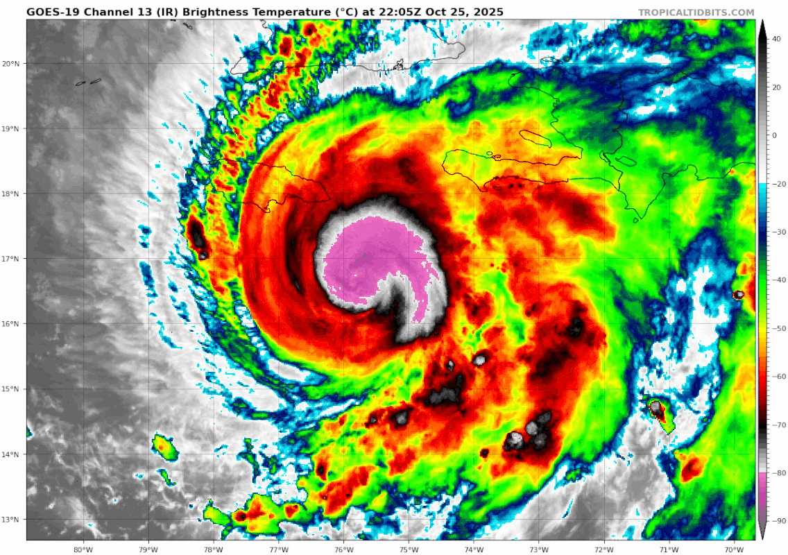
Blown Away wrote:[url]https://i.postimg.cc/5ywz0ywL/goes19-ir-13L-202510252205.gif [/url]8:00 PM EDT Sat Oct 25
Location: 16.5°N 75.6°W
Moving: W at 3 mph
Min pressure: 971 mb
Max sustained: 100 mph
8:00 PM EDT Sat Oct 25
Location: 16.5°N 75.6°W
Moving: W at 3 mph
Min pressure: 971 mb
Max sustained: 100 mphFORECAST POSITIONS AND MAX WINDS
INIT 25/2100Z 16.6N 75.5W 80 KT 90 MPH
12H 26/0600Z 16.7N 75.9W 100 KT 115 MPH
24H 26/1800Z 16.7N 76.5W 115 KT 130 MPH
36H 27/0600Z 16.7N 77.2W 135 KT 155 MPH
48H 27/1800Z 16.9N 77.6W 140 KT 160 MPH
60H 28/0600Z 17.6N 77.4W 130 KT 150 MPH
72H 28/1800Z 18.8N 76.7W 115 KT 130 MPH
96H 29/1800Z 22.0N 73.4W 90 KT 105 MPH
120H 30/1800Z 27.0N 69.0W 80 KT 90 MPH
Melissa was not predicted to lose latitude and IMO moving a little faster W than expected.
The eye dropsonde that just came in actually had the center down a little further at 16.4N, and I agree that W motion today has seemed faster than forecasted.
2 likes
-
CrazyC83
- Professional-Met

- Posts: 34316
- Joined: Tue Mar 07, 2006 11:57 pm
- Location: Deep South, for the first time!
Re: NATL: MELISSA - Hurricane - Discussion
With all that data, 90 kt seems the best intensity estimate to me.
7 likes
Re: NATL: MELISSA - Hurricane - Discussion
AL, 13, 2025102600, , BEST, 0, 165N, 757W, 90, 971, HU,
3 likes
-
WaveBreaking
- Category 2
- Posts: 728
- Joined: Sun Jun 30, 2024 11:33 am
- Location: US
Re: NATL: MELISSA - Hurricane - Discussion
The outflow fanning out to the W is really expansive. Eye should pop out sometime soon.

6 likes
I am NOT a professional meteorologist, so take all of my posts with a grain of salt. My opinions are mine and mine alone.
-
Hurricane2022
- Category 5
- Posts: 2092
- Joined: Tue Aug 23, 2022 11:38 pm
- Location: Araçatuba, Brazil
Re: NATL: MELISSA - Hurricane - Discussion
Recon showing that small double wind maxima again
1 likes
Sorry for the bad English sometimes...!
For reliable and detailed information for any meteorological phenomenon, please consult the National Hurricane Center, Joint Typhoon Warning Center , or your local Meteo Center.
--------
ECCE OMNIA NOVA FACIAM (Ap 21,5).
For reliable and detailed information for any meteorological phenomenon, please consult the National Hurricane Center, Joint Typhoon Warning Center , or your local Meteo Center.
--------
ECCE OMNIA NOVA FACIAM (Ap 21,5).
-
Hurricane2022
- Category 5
- Posts: 2092
- Joined: Tue Aug 23, 2022 11:38 pm
- Location: Araçatuba, Brazil
Re: NATL: MELISSA - Hurricane - Discussion

5 likes
Sorry for the bad English sometimes...!
For reliable and detailed information for any meteorological phenomenon, please consult the National Hurricane Center, Joint Typhoon Warning Center , or your local Meteo Center.
--------
ECCE OMNIA NOVA FACIAM (Ap 21,5).
For reliable and detailed information for any meteorological phenomenon, please consult the National Hurricane Center, Joint Typhoon Warning Center , or your local Meteo Center.
--------
ECCE OMNIA NOVA FACIAM (Ap 21,5).
Re: NATL: MELISSA - Hurricane - Discussion
South of west motion more apparent on this radar loop

4 likes
-
Keldeo1997
- Category 2
- Posts: 688
- Joined: Fri Oct 11, 2019 11:35 pm
-
Hurricane2022
- Category 5
- Posts: 2092
- Joined: Tue Aug 23, 2022 11:38 pm
- Location: Araçatuba, Brazil
Re: NATL: MELISSA - Hurricane - Discussion
More VHTs coming on the E eyewall.
3 likes
Sorry for the bad English sometimes...!
For reliable and detailed information for any meteorological phenomenon, please consult the National Hurricane Center, Joint Typhoon Warning Center , or your local Meteo Center.
--------
ECCE OMNIA NOVA FACIAM (Ap 21,5).
For reliable and detailed information for any meteorological phenomenon, please consult the National Hurricane Center, Joint Typhoon Warning Center , or your local Meteo Center.
--------
ECCE OMNIA NOVA FACIAM (Ap 21,5).

Re: NATL: MELISSA - Hurricane - Discussion
A recap of how things evolved from a single convective burst a few hours ago:

9 likes
TC naming lists: retirements and intensity
Most aggressive Advisory #1's in North Atlantic (cr. kevin for starting the list)
Most aggressive Advisory #1's in North Atlantic (cr. kevin for starting the list)
Who is online
Users browsing this forum: No registered users and 109 guests