13 miles until water for Katrina

This is the general tropical discussion area. Anyone can take their shot at predicting a storms path.

Moderator: S2k Moderators

Forum rules

The posts in this forum are NOT official forecasts and should not be used as such. They are just the opinion of the poster and may or may not be backed by sound meteorological data. They are NOT endorsed by any professional institution or STORM2K. For official information, please refer to products from the National Hurricane Center and National Weather Service.

Help Support Storm2K
Message
Author
krysof

#21 Postby krysof » Thu Aug 25, 2005 11:31 pm

2 weeks? I can't believe it. I just came back from my trip on August 22. Was this the TD 10 that everyone was talking about. If this is that same storm, why has it given TD 12? I know TD 11 was taken by Jose but shouldn't this have been TD 10 again.
0 likes   

mtm4319
Category 5
Category 5
Posts: 1537
Joined: Sun Sep 12, 2004 2:47 am
Location: Mobile, AL

#22 Postby mtm4319 » Thu Aug 25, 2005 11:34 pm

krysof wrote:2 weeks? I can't believe it. I just came back from my trip on August 22. Was this the TD 10 that everyone was talking about. If this is that same storm, why has it given TD 12? I know TD 11 was taken by Jose but shouldn't this have been TD 10 again.


10 dissipated, then combined with another wave, and it was indeterminable as to which system "won out" before becoming a depression again.

THE NWS RULES GOVERNING THE NAMING OF TROPICAL CYCLONES SPECIFY
THAT...WITHIN A BASIN...WHEN A CYCLONE FORMS FROM THE REMNANT OF A
PREVIOUSLY EXISTING CYCLONE...THE OLD NAME/NUMBER IS RETAINED.
TROPICAL DEPRESSION TWELVE HAS A COMPLEX GENESIS THAT LIKELY
INCLUDES A MID-LEVEL REMNANT OF FORMER TROPICAL DEPRESSION TEN. A
REVIEW OF SATELLITE AND RAWINSONDE DATA OVER THE PAST WEEK OR SO
SUGGESTS THAT A SECOND DISTURBANCE APPROACHED AND COMBINED WITH THE
MID-LEVEL REMNANT OF TROPICAL DEPRESSION TEN ON 20 AUGUST. BECAUSE
IT IS IMPOSSIBLE TO DETERMINE WHICH OF THESE TWO SYSTEMS IS
ASSOCIATED WITH TODAY'S GENESIS...WE HAVE ELECTED TO USE THE
DESIGNATION TWELVE RATHER THAN TEN FOR THE NEW DEPRESSION. THIS
SITUATION DIFFERS FROM LAST YEAR'S REGENERATION OF IVAN...IN WHICH
THE LOW-LEVEL REMNANT OF THAT SYSTEM REMAINED A DISTINCT FEATURE
THAT COULD BE FOLLOWED CONTINUOUSLY UNTIL IT REGENERATED.
0 likes   

User avatar
loon
S2K Supporter
S2K Supporter
Posts: 655
Joined: Mon Aug 30, 2004 4:50 pm
Location: Downtown Houston

#23 Postby loon » Thu Aug 25, 2005 11:35 pm

last couple of frames on the Key West radar show a major "clearing out" of the "eye" area...whats that all about?
0 likes   

User avatar
skysummit
S2K Supporter
S2K Supporter
Posts: 5305
Age: 49
Joined: Tue Aug 31, 2004 11:09 pm
Location: Ponchatoula, LA
Contact:

#24 Postby skysummit » Thu Aug 25, 2005 11:35 pm

Wow...I said she'd be over water by 1a.m. CDT and I think she'll make it!
0 likes   

User avatar
CronkPSU
S2K Supporter
S2K Supporter
Posts: 2021
Joined: Sun Aug 07, 2005 10:44 pm
Location: Avalon Park, FL

#25 Postby CronkPSU » Thu Aug 25, 2005 11:36 pm

0 likes   

User avatar
baitism
Category 1
Category 1
Posts: 266
Joined: Wed Jul 06, 2005 3:00 pm
Location: Overland Park, KS

#26 Postby baitism » Thu Aug 25, 2005 11:36 pm

loon wrote:last couple of frames on the Key West radar show a major "clearing out" of the "eye" area...whats that all about?


Dry air and land interaction.
0 likes   

User avatar
loon
S2K Supporter
S2K Supporter
Posts: 655
Joined: Mon Aug 30, 2004 4:50 pm
Location: Downtown Houston

#27 Postby loon » Thu Aug 25, 2005 11:37 pm

cool, thanks. looks like she is almost getting her first steps off shore
0 likes   

krysof

#28 Postby krysof » Thu Aug 25, 2005 11:37 pm

Thanks for that info.
0 likes   

User avatar
baitism
Category 1
Category 1
Posts: 266
Joined: Wed Jul 06, 2005 3:00 pm
Location: Overland Park, KS

#29 Postby baitism » Thu Aug 25, 2005 11:41 pm

Yeah, shes just about to exit. The bad news is that the western bands are rejuvenating pretty well offshore. This storm held its structure, therefore it should start intensifying right after it gets back over water....not to mention 90+ degree water.
0 likes   

User avatar
deltadog03
Professional-Met
Professional-Met
Posts: 3580
Joined: Tue Jul 05, 2005 6:16 pm
Location: Macon, GA

#30 Postby deltadog03 » Thu Aug 25, 2005 11:42 pm

west and SW quads have EXPLODED!!! went from greens to reds on radar
0 likes   

User avatar
Wnghs2007
Category 5
Category 5
Posts: 6836
Age: 36
Joined: Wed Mar 24, 2004 11:14 pm
Location: Gwinnett-Barrow Line; Georgia
Contact:

#31 Postby Wnghs2007 » Thu Aug 25, 2005 11:46 pm

0 likes   

User avatar
sponger
S2K Supporter
S2K Supporter
Posts: 1626
Joined: Thu Jul 22, 2004 11:26 am
Location: St Augustine

#32 Postby sponger » Thu Aug 25, 2005 11:49 pm

Edge of the western eye coming offshore. I want to watch it all night!


love it waiting and staying up to see her reemerge over the GOM me and a couple beers.


I thought I was the only one!
0 likes   

krysof

#33 Postby krysof » Thu Aug 25, 2005 11:51 pm

Katrina isn't even in the prime of her life. That very warm water in the gulf may act like a time bomb. As soon as the eye touches it, it explodes.
0 likes   

PurdueWx80
Professional-Met
Professional-Met
Posts: 2720
Joined: Fri Aug 13, 2004 8:33 pm
Location: Madison, WI
Contact:

#34 Postby PurdueWx80 » Thu Aug 25, 2005 11:53 pm

Secondary eyewall forming just north of keys up towards southern Dade county - evident in reflectivity and velocity data (2 speed maxes in green going towards Miami radar site). Could be the beginnings of some sort of eyewall replacement cycle.

Image

Image
0 likes   

User avatar
skysummit
S2K Supporter
S2K Supporter
Posts: 5305
Age: 49
Joined: Tue Aug 31, 2004 11:09 pm
Location: Ponchatoula, LA
Contact:

#35 Postby skysummit » Thu Aug 25, 2005 11:53 pm

Has she slowed extremely, or maybe even stalled? On the Key West radar, it looks like she's hit the breaks right before the coast. Anyone else see it?
0 likes   

Frank P
S2K Supporter
S2K Supporter
Posts: 2779
Joined: Fri Aug 29, 2003 10:52 am
Location: Biloxi Beach, Ms
Contact:

#36 Postby Frank P » Thu Aug 25, 2005 11:56 pm

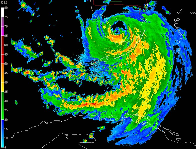
not on this loop, getting really close to the GOM now... this is happening well before anyone predicted it...

http://www.srh.noaa.gov/ridge/byx_NCR_lp.shtml
0 likes   

superfly

#37 Postby superfly » Thu Aug 25, 2005 11:59 pm

NHC had predicted 24 hours over land. It will instead be around 8 hours.
0 likes   

User avatar
sponger
S2K Supporter
S2K Supporter
Posts: 1626
Joined: Thu Jul 22, 2004 11:26 am
Location: St Augustine

#38 Postby sponger » Thu Aug 25, 2005 11:59 pm

looks like Havanah has some nasty squalls coming in.
0 likes   

User avatar
sponger
S2K Supporter
S2K Supporter
Posts: 1626
Joined: Thu Jul 22, 2004 11:26 am
Location: St Augustine

#39 Postby sponger » Fri Aug 26, 2005 12:02 am

I believe the original prediction was 36 hours. THE GFDL was solid with this storm, except for the problematic intensity estimate.
0 likes   

krysof

#40 Postby krysof » Fri Aug 26, 2005 12:05 am

Good news, Katrina is below hurricane status as of the 1:00 am advisory. Who knows, maybe it will weaken further. So there's some good news here.
0 likes   


Return to “Talkin' Tropics”

Who is online

Users browsing this forum: bird, Google [Bot] and 157 guests