So far:
Mandatory Evacs:
Grand Isle and Lower Jefferson Parish
Plaquemines Parish
St. Charles Parish
Voluntary:
Terrebonne Parish below the Intracoastal Waterway
St. Bernard Parish (Precautionary Evacuation)
Contraflow will probably begin at 4pm.
LA\NO Evacuation Orders, Emergency Info
Moderator: S2k Moderators
Forum rules

The posts in this forum are NOT official forecasts and should not be used as such. They are just the opinion of the poster and may or may not be backed by sound meteorological data. They are NOT endorsed by any professional institution or STORM2K. For official information, please refer to products from the National Hurricane Center and National Weather Service.
-
skysummit

- S2K Supporter

- Posts: 5305
- Age: 50
- Joined: Tue Aug 31, 2004 11:09 pm
- Location: Ponchatoula, LA
- Contact:
LA\NO Evacuation Orders, Emergency Info
Last edited by skysummit on Sat Aug 27, 2005 9:08 am, edited 1 time in total.
0 likes
-
wx247

- S2K Supporter
- Posts: 14279
- Age: 42
- Joined: Wed Feb 05, 2003 10:35 pm
- Location: Monett, Missouri
- Contact:
You might want to make this just an evacuation thread so we don't have people making new ones for every evacuation order. I know you did, but if they are only looking at the title they might not know. 
0 likes
Personal Forecast Disclaimer:
The posts in this forum are NOT official forecast and should not be used as such. They are just the opinion of the poster and may or may not be backed by sound meteorological data. They are NOT endorsed by any professional institution or storm2k.org. For official information, please refer to the NHC and NWS products.
The posts in this forum are NOT official forecast and should not be used as such. They are just the opinion of the poster and may or may not be backed by sound meteorological data. They are NOT endorsed by any professional institution or storm2k.org. For official information, please refer to the NHC and NWS products.


-
mf_dolphin

- Category 5

- Posts: 17758
- Age: 69
- Joined: Tue Oct 08, 2002 2:05 pm
- Location: St Petersburg, FL
- Contact:

Traffic cameras
found this link on the wwltv board
This will show you when gridlock gets bad.
http://www.dotd.louisiana.gov/press/tra ... no_cameras
This will show you when gridlock gets bad.
http://www.dotd.louisiana.gov/press/tra ... no_cameras
0 likes
-
bvigal

- S2K Supporter
- Posts: 2276
- Joined: Sun Jul 24, 2005 8:49 am
- Location: British Virgin Islands
- Contact:
Re: Traffic cameras
lapeym wrote:found this link on the wwltv board
This will show you when gridlock gets bad.
http://www.dotd.louisiana.gov/press/tra ... no_cameras
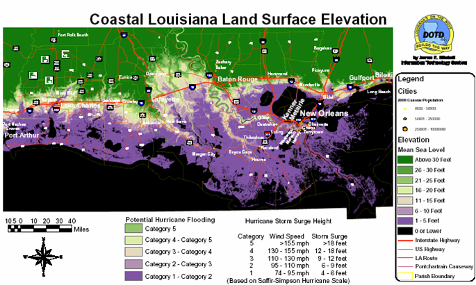
Thanks! And on the same site, check out this elevation map - scary!
http://www8.dotd.louisiana.gov/emergency/images/Coastal_Land_Elevation.png[/url]
0 likes
-
soonertwister
- Category 5
- Posts: 1091
- Joined: Mon Jun 16, 2003 2:52 pm
Re: Traffic cameras
lapeym wrote:found this link on the wwltv board
This will show you when gridlock gets bad.
http://www.dotd.louisiana.gov/press/tra ... no_cameras
I expected to see a lot more traffic by this time. As I have suspected, I think that many people in NOLA metro live in a state of denial regarding major hurricane threats to their city. There hasn't been a major hurricane hit NOLA directly in about 40 years, and frequently the apathy becomes more sustained the longer the time has been since the last big hurricane event.
Tomorrow is probably going to be pretty insane on the roads out of NOLA if there isn't a significant change in the official track guidance.
0 likes
-
storms in NC

- S2K Supporter
- Posts: 2338
- Joined: Thu Jul 28, 2005 2:58 pm
- Location: Wallace,NC 40 miles NE of Wilm
- Contact:
-
AlabamaDave
- Tropical Storm

- Posts: 169
- Joined: Wed Aug 11, 2004 6:44 pm
Re: Traffic cameras
soonertwister wrote:I expected to see a lot more traffic by this time. As I have suspected, I think that many people in NOLA metro live in a state of denial regarding major hurricane threats to their city. There hasn't been a major hurricane hit NOLA directly in about 40 years, and frequently the apathy becomes more sustained the longer the time has been since the last big hurricane event.
Tomorrow is probably going to be pretty insane on the roads out of NOLA if there isn't a significant change in the official track guidance.
None of our family in the New Orleans area are evacuating until tomorrow. They are tired of evacuating after so many false alarms and simply won't leave today. I tried explaining that this time N.O. is really close to where all of the computer model forecasts are taking the storm (in contrast to Ivan), but it doesn't matter. I imagine this sense of "yea, right, here we go again" is widespread across the city.
Too many there also recall the hullaballoo over Georges. That storm was hyped up much like this one, and then it missed the city and also never reached the projected intensity.
0 likes
-
brunota2003

- S2K Supporter
- Posts: 9476
- Age: 35
- Joined: Sat Jul 30, 2005 9:56 pm
- Location: Stanton, KY...formerly Havelock, NC
- Contact:
storms in NC wrote:we have a window of 40 -or + hours now. That is for the eye. I think I would be going some where now. The storm start way befor the eye gets there.
Yep, I agree, but there is only about 30 - or + hours before the Tropical storm force winds reach the coast and after that its going to just go down hill, so everyone needs to go now, otherwise they could be stuck on the roads in a traffic jam while the storm makes landfall, right now NOLA is already pushing their luck...
0 likes

Traffic cams from NOLA.com
http://www.nola.com/traffic/cams/
I'm not sure right now (Sat noon) if they are updating as fast as advertised, but this might help if you are wondering what traffic is like.
http://www.nola.com/traffic/cams/
I'm not sure right now (Sat noon) if they are updating as fast as advertised, but this might help if you are wondering what traffic is like.
0 likes
-
wx247
- S2K Supporter
- Posts: 14279
- Age: 42
- Joined: Wed Feb 05, 2003 10:35 pm
- Location: Monett, Missouri
- Contact:
Press conference on NOLA is expected within 5 minutes.
0 likes
Personal Forecast Disclaimer:
The posts in this forum are NOT official forecast and should not be used as such. They are just the opinion of the poster and may or may not be backed by sound meteorological data. They are NOT endorsed by any professional institution or storm2k.org. For official information, please refer to the NHC and NWS products.
The posts in this forum are NOT official forecast and should not be used as such. They are just the opinion of the poster and may or may not be backed by sound meteorological data. They are NOT endorsed by any professional institution or storm2k.org. For official information, please refer to the NHC and NWS products.

Who is online
Users browsing this forum: No registered users and 104 guests