


TD 14?
Moderator: S2k Moderators
Forum rules

The posts in this forum are NOT official forecasts and should not be used as such. They are just the opinion of the poster and may or may not be backed by sound meteorological data. They are NOT endorsed by any professional institution or STORM2K. For official information, please refer to products from the National Hurricane Center and National Weather Service.
-
johngaltfla

- Category 5

- Posts: 2073
- Joined: Sun Jul 10, 2005 9:17 pm
- Location: Sarasota County, FL
- Contact:

-
txwatcher91
- Category 5
- Posts: 1498
- Joined: Tue Aug 02, 2005 2:29 pm

-
ConvergenceZone
.gif)
- Category 5
- Posts: 5241
- Joined: Fri Jul 29, 2005 1:40 am
- Location: Northern California
x-y-no wrote:Looks good, but it also looks likely to be picked up by a trough in the 3-day timeframe.
Yep, they just mentioned that this will turn fairly quickly into the open Atlantic for the fish to worry about. It's just the way the high pressure is set up right now. It's been a hellish season already, so they can all be fish for all I care!
0 likes
-
dolebot_Broward_NW
- Category 2

- Posts: 529
- Joined: Fri Sep 10, 2004 6:38 am
-
hurricanefreak1988
- Category 3

- Posts: 869
- Joined: Thu Jul 22, 2004 10:13 pm
- Location: Fayetteville, NC
- Contact:
-
wx247

- S2K Supporter

- Posts: 14279
- Age: 42
- Joined: Wed Feb 05, 2003 10:35 pm
- Location: Monett, Missouri
- Contact:
Outflow looks great, especially on the southern quadrant.
0 likes
Personal Forecast Disclaimer:
The posts in this forum are NOT official forecast and should not be used as such. They are just the opinion of the poster and may or may not be backed by sound meteorological data. They are NOT endorsed by any professional institution or storm2k.org. For official information, please refer to the NHC and NWS products.
The posts in this forum are NOT official forecast and should not be used as such. They are just the opinion of the poster and may or may not be backed by sound meteorological data. They are NOT endorsed by any professional institution or storm2k.org. For official information, please refer to the NHC and NWS products.
-
spinfan4eva
- Category 1

- Posts: 295
- Joined: Tue Aug 23, 2005 1:27 am
- Location: Jacksonville, Florida
- Contact:
-
Matt-hurricanewatcher
-
WeatherEmperor
- S2K Supporter
- Posts: 4806
- Age: 41
- Joined: Thu Sep 04, 2003 2:54 pm
- Location: South Florida
-
wxman57

- Moderator-Pro Met

- Posts: 23164
- Age: 68
- Joined: Sat Jun 21, 2003 8:06 pm
- Location: Houston, TX (southwest)
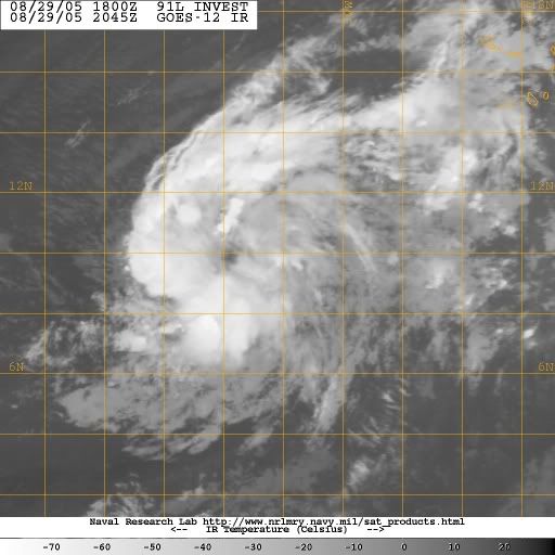
I doubt it's TD 14. Nope, it's TS Lee. Take a look at the 0730Z QS image. Several un-flagged 40kt westerly winds. I think it's already a TS and strengthening. NHC was preoccupied with some other storm today.
http://manati.orbit.nesdis.noaa.gov/sto ... 9_91as.png
http://manati.orbit.nesdis.noaa.gov/sto ... 9_91as.png
0 likes
wxman57 wrote:I doubt it's TD 14. Nope, it's TS Lee. Take a look at the 0730Z QS image. Several un-flagged 40kt westerly winds. I think it's already a TS and strengthening. NHC was preoccupied with some other storm today.
http://manati.orbit.nesdis.noaa.gov/sto ... 9_91as.png
TD13 reminded me of TD10. Now this reminds of Ivan, which rapidly increased to a Cat3 in three days of classification almost one year ago. Someone teach it to fish!
0 likes
-
senorpepr

- Military Met/Moderator

- Posts: 12542
- Age: 43
- Joined: Fri Aug 22, 2003 9:22 pm
- Location: Mackenbach, Germany
- Contact:
From the 5:30pm TWO
THE AREA OF LOW PRESSURE LOCATED ABOUT 1500 MILES EAST OF THE LESSER
ANTILLES CONTINUES TO SHOW SIGNS OF ORGANIZATION AS IT MOVES TO THE
WEST-NORTHWEST. THIS SYSTEM HAS THE POTENTIAL TO BECOME A
TROPICAL DEPRESSION OVER THE NEXT COUPLE OF DAYS AS UPPER-LEVEL
WINDS BECOME MORE CONDUCIVE FOR DEVELOPMENT.
0 likes
Who is online
Users browsing this forum: chaser1, ljmac75, MarioProtVI, Ulf and 46 guests