Tropical Storm Maria,Comments,Sat Pics,Models Thread

This is the general tropical discussion area. Anyone can take their shot at predicting a storms path.

Moderator: S2k Moderators

Forum rules

The posts in this forum are NOT official forecasts and should not be used as such. They are just the opinion of the poster and may or may not be backed by sound meteorological data. They are NOT endorsed by any professional institution or STORM2K. For official information, please refer to products from the National Hurricane Center and National Weather Service.

Help Support Storm2K
Message
Author
GalvestonDuck
Category 5
Category 5
Posts: 15941
Age: 57
Joined: Fri Oct 11, 2002 8:11 am
Location: Galveston, oh Galveston (And yeah, it's a barrier island. Wanna make something of it?)

#161 Postby GalvestonDuck » Fri Sep 02, 2005 2:19 pm

no advance wrote:Here is a link. Also notice the southern system is making a comeback. Dont download with dial up. http://www.atmos.washington.edu/~ovens/ ... nhanced+12


Ugh, look at all the freaking dry air blowing up from TX to the OH Valley and into the NE where you-know-who was.
0 likes   

MiamiensisWx

#162 Postby MiamiensisWx » Fri Sep 02, 2005 2:21 pm

GalvestonDuck wrote:Ugh, look at all the freaking dry air blowing up from TX to the OH Valley and into the NE where you-know-who was.


It makes you realize that Katrina's impacts were NOT limited to the Gulf coast... even when inland, Katrina still produced many damaging tornadoes and heavy rainfall.
0 likes   

User avatar
cycloneye
Admin
Admin
Posts: 148497
Age: 69
Joined: Thu Oct 10, 2002 10:54 am
Location: San Juan, Puerto Rico

#163 Postby cycloneye » Fri Sep 02, 2005 7:35 pm

TPNT KGWC 030030
A. TROPICAL STORM MARIA
B. 02/2331Z (79)
C. 22.0N/4
D. 51.5W/1
E. SIX/GOES12
F. T3.0/3.0/D1.0/24HRS -02/2331Z-
G. IR/EIR/VIS/MSI

38A/PBO SBC/ANMTN. LLCC WRAPS .40 ON LOG10 SPIRAL
GIVING IT A DT OF 2.5. FT BASED ON PT, MET SUPPORTS.

AODT: T4.5 (UCCR)

PERSINGER


Air Force sat estimates for Tropical Storm Maria..
0 likes   
Visit the Caribbean-Central America Weather Thread where you can find at first post web cams,radars
and observations from Caribbean basin members Click Here

User avatar
Hyperstorm
Category 5
Category 5
Posts: 1500
Joined: Sun Sep 07, 2003 3:48 am
Location: Ocala, FL

#164 Postby Hyperstorm » Fri Sep 02, 2005 11:00 pm

The center of Maria appears to be much farther north and west than where Knabb has it positioned. You could easily identify "at least" a Mid-level spin very near 23.5N 52.5W. If it's a MLC, it will likely become the dominant one during the next 24 hours as it appears quite strong. If it's the LLC, it is moving NNW with a tendency more northward.

Convection is developing to the east of the MLC and if this continues, the system will be a hurricane soon. The outflow is expanding and becoming symmetrical around the storm, so development in the short term will likely be influenced by inner-core re-organizations...
0 likes   

User avatar
JamesFromMaine2
Category 4
Category 4
Posts: 989
Joined: Tue Jul 19, 2005 1:38 am
Location: Portland Maine USA
Contact:

#165 Postby JamesFromMaine2 » Fri Sep 02, 2005 11:02 pm

I am trying to find something out! Does any one think that it might have a chance of hitting Maine?
0 likes   

Brent
S2K Supporter
S2K Supporter
Posts: 38265
Age: 37
Joined: Sun May 16, 2004 10:30 pm
Location: Tulsa Oklahoma
Contact:

#166 Postby Brent » Fri Sep 02, 2005 11:59 pm

JamesFromMaine2 wrote:I am trying to find something out! Does any one think that it might have a chance of hitting Maine?


Less than 5%.
0 likes   
#neversummer

Matt-hurricanewatcher

#167 Postby Matt-hurricanewatcher » Sat Sep 03, 2005 12:50 am

A deep Cdo has formed over the LLC. In with the outflow becoming much better defined out of all quads. I expect this to become a hurricane with in the next 12 hours. If things remind favable theres a shot she could become quite the storm.
0 likes   

User avatar
cycloneye
Admin
Admin
Posts: 148497
Age: 69
Joined: Thu Oct 10, 2002 10:54 am
Location: San Juan, Puerto Rico

#168 Postby cycloneye » Sat Sep 03, 2005 7:40 am

TPNT KGWC 031230
A. TROPICAL STORM MARIA
B. 03/1131Z (79)
C. 23.7N/2
D. 53.1W/9
E. SIX/GOES12
F. T2.5/3.0/S0.0/24HRS -03/1131Z-
G. IR/EIR/VIS/MSI

40A/PBO SBC/ANMTN. LLCC WRAPS .50 ON LOG10 SPIRAL
YIELDING A DT OF 2.5. FT BASED ON DT. PT AND MET AGREE.

AODT: T5.0 (UCCR)

KAMINSKI


Air Force T numbers.
0 likes   
Visit the Caribbean-Central America Weather Thread where you can find at first post web cams,radars
and observations from Caribbean basin members Click Here

Matt-hurricanewatcher

#169 Postby Matt-hurricanewatcher » Sat Sep 03, 2005 8:10 am

The visible shows a classic Cdo has formed this morning located over the LLC. With banding/outflow forming out of all quads. It also has started to develop the look of a fastly developing system. I would not be suprized to look this afternoon to see a eye. This system has a favable upper level enviorment/warm sea surface temperatures.

I would give this a 60 to 65 mph at this time.
0 likes   

User avatar
Thunder44
Category 5
Category 5
Posts: 5922
Age: 44
Joined: Mon Jun 09, 2003 7:53 pm
Location: New York City

#170 Postby Thunder44 » Sat Sep 03, 2005 8:27 am

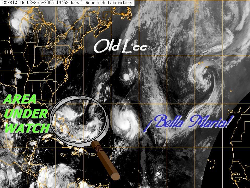
Does this look like a 40-50mph TS to any of you?

Image
0 likes   

User avatar
Hyperstorm
Category 5
Category 5
Posts: 1500
Joined: Sun Sep 07, 2003 3:48 am
Location: Ocala, FL

#171 Postby Hyperstorm » Sat Sep 03, 2005 8:29 am

196
WHXX01 KWBC 031221
CHGHUR

DISCLAIMER...NUMERICAL MODELS ARE SUBJECT TO LARGE ERRORS.
PLEASE REFER TO TPC/NHC OFFICIAL FORECASTS FOR TROPICAL CYCLONES.

NATIONAL HURRICANE CENTER NORTH ATLANTIC OBJECTIVE AIDS FOR

TROPICAL STORM MARIA (AL142005) ON 20050903 1200 UTC

...00 HRS... ...12 HRS... ...24 HRS... ...36 HRS...
050903 1200 050904 0000 050904 1200 050905 0000

LAT LON LAT LON LAT LON LAT LON
BAMD 24.2N 53.2W 25.8N 54.6W 27.5N 55.8W 29.1N 56.6W
BAMM 24.2N 53.2W 25.9N 54.7W 27.7N 55.9W 29.6N 56.8W
A98E 24.2N 53.2W 26.1N 55.1W 28.2N 56.3W 30.8N 56.9W
LBAR 24.2N 53.2W 26.2N 54.4W 28.2N 55.5W 30.0N 56.2W
SHIP 45KTS 50KTS 56KTS 61KTS
DSHP 45KTS 50KTS 56KTS 61KTS

...48 HRS... ...72 HRS... ...96 HRS... ..120 HRS...
050905 1200 050906 1200 050907 1200 050908 1200

LAT LON LAT LON LAT LON LAT LON
BAMD 30.1N 57.3W 31.3N 58.1W 31.0N 59.1W 30.7N 60.8W
BAMM 31.2N 57.5W 34.0N 57.3W 34.9N 56.2W 36.4N 56.6W
A98E 33.5N 57.1W 39.1N 51.3W 44.2N 35.8W 49.2N 18.0W
LBAR 32.0N 57.0W 34.9N 56.6W 37.2N 53.0W 38.3N 47.5W
SHIP 65KTS 71KTS 74KTS 72KTS
DSHP 65KTS 71KTS 74KTS 72KTS

...INITIAL CONDITIONS...
LATCUR = 24.2N LONCUR = 53.2W DIRCUR = 315DEG SPDCUR = 13KT
LATM12 = 22.0N LONM12 = 51.0W DIRM12 = 310DEG SPDM12 = 11KT
LATM24 = 21.3N LONM24 = 49.5W
WNDCUR = 45KT RMAXWD = 30NM WNDM12 = 45KT
CENPRS = 1000MB OUTPRS = 1013MB OUTRAD = 200NM SDEPTH = D
RD34NE = 100NM RD34SE = 30NM RD34SW = 0NM RD34NW = 60NM

Tropical models are keeping the intensity of Maria at 50 mph. Of course, this is all due to the numbers from TAFB and SAB still estimating 50 mph winds. I'm quite sure there are stronger winds than those estimated since the persistent convection has rotated over what was its MLC yesterday. Just as Matt said, 60-65 mph sounds just about right.

The outflow seems somewhat restricted on the SW quadrant, but that shouldn't keep it from becoming a hurricane during the next 24 hours...
0 likes   

User avatar
Hyperstorm
Category 5
Category 5
Posts: 1500
Joined: Sun Sep 07, 2003 3:48 am
Location: Ocala, FL

#172 Postby Hyperstorm » Sat Sep 03, 2005 8:31 am

Thunder44 wrote:Does this look like a 40-50mph TS to any of you?

Image


That is due to the fact that they have the center positioned on the south-eastern edge of the deepest convection near 53W. I'm seeing that the earlier MLC near 54W is likely becoming a LLC. If this is confirmed as the true LLC, the current intensity is likely much higher...
0 likes   

Matt-hurricanewatcher

#173 Postby Matt-hurricanewatcher » Sat Sep 03, 2005 9:18 am

24.8/55.5 moving northwest. The outflow is becoming very well defined over the western quad. This thing is wraping up fast now. In moisture is feeding into it from banding over the south. A hurricane with in 12 hours.
0 likes   

User avatar
cycloneye
Admin
Admin
Posts: 148497
Age: 69
Joined: Thu Oct 10, 2002 10:54 am
Location: San Juan, Puerto Rico

#174 Postby cycloneye » Sat Sep 03, 2005 1:50 pm


TROPICAL STORM MARIA (AL142005) ON 20050903 1800 UTC

...00 HRS... ...12 HRS... ...24 HRS... ...36 HRS...
050903 1800 050904 0600 050904 1800 050905 0600

LAT LON LAT LON LAT LON LAT LON
BAMD 25.5N 54.4W 27.2N 55.6W 29.1N 56.7W 31.0N 57.7W
BAMM 25.5N 54.4W 27.2N 55.4W 29.2N 56.5W 31.2N 57.3W
A98E 25.5N 54.4W 27.7N 56.2W 29.8N 56.9W 31.6N 57.6W
LBAR 25.5N 54.4W 27.6N 55.5W 29.7N 56.6W 32.0N 57.3W
SHIP 60KTS 72KTS 83KTS 89KTS
DSHP 60KTS 72KTS 83KTS 89KTS

...48 HRS... ...72 HRS... ...96 HRS... ..120 HRS...
050905 1800 050906 1800 050907 1800 050908 1800

LAT LON LAT LON LAT LON LAT LON
BAMD 32.8N 58.3W 36.1N 56.1W 38.9N 47.5W 40.0N 34.3W
BAMM 33.2N 57.8W 36.3N 56.5W 37.9N 51.9W 39.5N 46.4W
A98E 33.4N 57.7W 35.2N 54.9W 37.0N 48.3W 39.2N 39.7W
LBAR 34.1N 57.3W 38.2N 54.9W 40.6N 47.5W 41.2N 37.6W
SHIP 94KTS 98KTS 90KTS 81KTS
DSHP 94KTS 98KTS 90KTS 81KTS

...INITIAL CONDITIONS...
LATCUR = 25.5N LONCUR = 54.4W DIRCUR = 320DEG SPDCUR = 15KT
LATM12 = 23.0N LONM12 = 52.0W DIRM12 = 323DEG SPDM12 = 16KT
LATM24 = 21.6N LONM24 = 50.2W
WNDCUR = 60KT RMAXWD = 25NM WNDM12 = 45KT
CENPRS = 995MB OUTPRS = 1013MB OUTRAD = 200NM SDEPTH = D
RD34NE = 100NM RD34SE = 60NM RD34SW = 20NM RD34NW = 60NM


For some who may be thinking about Maria may get close to the US East Coast nothing of that as this storm soon to be a hurricane is at fishland territory and will continue that way.

Image
0 likes   
Visit the Caribbean-Central America Weather Thread where you can find at first post web cams,radars
and observations from Caribbean basin members Click Here

User avatar
Andrew92
S2K Supporter
S2K Supporter
Posts: 3247
Age: 41
Joined: Mon Jun 16, 2003 12:35 am
Location: Phoenix, Arizona

#175 Postby Andrew92 » Sat Sep 03, 2005 1:53 pm

I was just about to say that it looks just a bit stronger than 60 mph. I am now fully thinking this will be a hurricane either tonight or early tomorrow morning.

-Andrew92
0 likes   

WeatherEmperor
S2K Supporter
S2K Supporter
Posts: 4806
Age: 41
Joined: Thu Sep 04, 2003 2:54 pm
Location: South Florida

#176 Postby WeatherEmperor » Sat Sep 03, 2005 2:23 pm

[quote="Andrew92"]I was just about to say that it looks just a bit stronger than 60 mph. I am now fully thinking this will be a hurricane either tonight or early tomorrow morning.

-Andrew92[/quote

yup. looks pretty close to a hurricane to me too.

<RICKY>
0 likes   

User avatar
cycloneye
Admin
Admin
Posts: 148497
Age: 69
Joined: Thu Oct 10, 2002 10:54 am
Location: San Juan, Puerto Rico

#177 Postby cycloneye » Sat Sep 03, 2005 2:26 pm

Yep 70 mph at 5 PM.
0 likes   
Visit the Caribbean-Central America Weather Thread where you can find at first post web cams,radars
and observations from Caribbean basin members Click Here

User avatar
HURAKAN
Professional-Met
Professional-Met
Posts: 46086
Age: 38
Joined: Thu May 20, 2004 4:34 pm
Location: Key West, FL
Contact:

#178 Postby HURAKAN » Sat Sep 03, 2005 3:19 pm

Image
0 likes   

Matt-hurricanewatcher

#179 Postby Matt-hurricanewatcher » Sat Sep 03, 2005 3:22 pm

Maria sure has gotten big alot like her sister Katrina started doing before she bombed
0 likes   

User avatar
cycloneye
Admin
Admin
Posts: 148497
Age: 69
Joined: Thu Oct 10, 2002 10:54 am
Location: San Juan, Puerto Rico

#180 Postby cycloneye » Sat Sep 03, 2005 3:51 pm

Based on the excellent presentation on sat pics today and on how rapid this system has increased it's winds I would not be surprised if it becomes not a cat 2 as NHC does at 5 PM but in the 4th major of the season.However thankfully it is at fishland and will mantain as a big fish.
0 likes   
Visit the Caribbean-Central America Weather Thread where you can find at first post web cams,radars
and observations from Caribbean basin members Click Here


Return to “Talkin' Tropics”

Who is online

Users browsing this forum: Wein and 119 guests