Interesting chart comparing 2005 hurricane season to 1933...

This is the general tropical discussion area. Anyone can take their shot at predicting a storms path.

Moderator: S2k Moderators

Forum rules

The posts in this forum are NOT official forecasts and should not be used as such. They are just the opinion of the poster and may or may not be backed by sound meteorological data. They are NOT endorsed by any professional institution or STORM2K. For official information, please refer to products from the National Hurricane Center and National Weather Service.

Help Support Storm2K
Message
Author
Weather Wizard
Tropical Wave
Tropical Wave
Posts: 2
Joined: Mon Jul 25, 2005 12:49 pm

#21 Postby Weather Wizard » Mon Jul 25, 2005 12:57 pm

If you put 1995 on there when there were 19 named storms, the G storm wasn't named until August 10. :eek:
0 likes   

User avatar
johngaltfla
Category 5
Category 5
Posts: 2069
Joined: Sun Jul 10, 2005 9:17 pm
Location: Sarasota County, FL
Contact:

#22 Postby johngaltfla » Mon Jul 25, 2005 2:43 pm

It almost looks like July 05 is August 04, etc. If that's the case there appears to be a statistical chance we'll be 5 or 6 storms higher in number this August. Although as a weather watcher, I would find that fascinating. But the consequences of such a jump in the number of storms would have devestating results.

:eek:
0 likes   

User avatar
Hyperstorm
Category 5
Category 5
Posts: 1500
Joined: Sun Sep 07, 2003 3:48 am
Location: Ocala, FL

#23 Postby Hyperstorm » Sun Aug 07, 2005 8:47 pm

Yet another tropical storm for the record-setting season...

Image

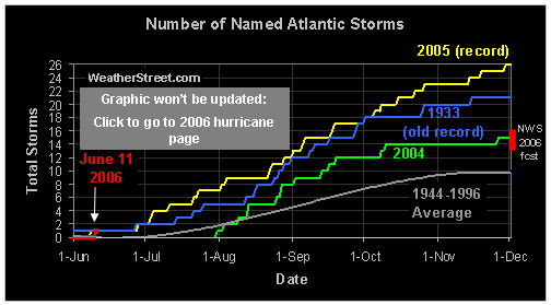
Something to note so far this year is that the majority of the cyclones are only staying as tropical storms and don't reach hurricane strength. If the season ended today, the season would be considered slightly below average overall (specifically hurricanes category) with 9 named storms, 2 hurricanes, 2 major hurricanes.
0 likes   

User avatar
Swimdude
Category 5
Category 5
Posts: 2270
Joined: Mon Jul 26, 2004 11:57 am
Location: Houston, TX

#24 Postby Swimdude » Sun Aug 07, 2005 9:01 pm

Haha we'd have to have ZERO storms for a MONTH to catch up with 2004!
0 likes   

User avatar
Hyperstorm
Category 5
Category 5
Posts: 1500
Joined: Sun Sep 07, 2003 3:48 am
Location: Ocala, FL

#25 Postby Hyperstorm » Wed Aug 24, 2005 9:01 am

Up the ramp we go with Jose and Katrina...

Something interesting to note is that the gap between the 2005 and 2004 seasons has been closing gradually compared to earlier in the season. Let's see if that continues or if it continues to climb insanely.
0 likes   

User avatar
wxwatcher91
Category 5
Category 5
Posts: 1606
Joined: Wed Jul 06, 2005 2:43 pm
Location: Keene, NH
Contact:

#26 Postby wxwatcher91 » Wed Aug 24, 2005 9:10 am

Hyperstorm wrote:Up the ramp we go with Jose and Katrina...

Something interesting to note is that the gap between the 2005 and 2004 seasons has been closing gradually compared to earlier in the season. Let's see if that continues or if it continues to climb insanely.


yeah we got "dangerously" close during that lull... another interesting thing is that the lull and then two name storms very quickly is very similar to the lull in 2004 in late Sep and early Oct and then two quick storms...
0 likes   

User avatar
johngaltfla
Category 5
Category 5
Posts: 2069
Joined: Sun Jul 10, 2005 9:17 pm
Location: Sarasota County, FL
Contact:

#27 Postby johngaltfla » Wed Aug 24, 2005 9:09 pm

Bump for those who forget. September could be a mother. And check out the MJO thread.

:eek: :eek: :eek:
0 likes   

User avatar
Astro_man92
Category 5
Category 5
Posts: 1493
Joined: Sun Jul 17, 2005 1:26 am
Contact:

LOL

#28 Postby Astro_man92 » Thu Aug 25, 2005 12:42 am

:lol: this thread havs been reserected 4 times :lol:
0 likes   

recmod
Tropical Storm
Tropical Storm
Posts: 214
Joined: Sat Aug 28, 2004 8:57 pm
Location: Orlando, FL
Contact:

#29 Postby recmod » Tue Sep 06, 2005 8:17 am

* Bump *

And the graph continues to show what an amazing season 2005 really is....

--Lou
0 likes   

User avatar
cjrciadt
S2K Supporter
S2K Supporter
Posts: 1616
Joined: Mon Aug 22, 2005 1:11 pm
Location: Kissimmee, FL

#30 Postby cjrciadt » Tue Sep 06, 2005 8:20 am

Add Nate and soon to be Ophelia. :raincloud:
0 likes   

User avatar
JamesFromMaine2
Category 4
Category 4
Posts: 989
Joined: Tue Jul 19, 2005 1:38 am
Location: Portland Maine USA
Contact:

#31 Postby JamesFromMaine2 » Tue Sep 06, 2005 9:01 am

If theres 20 storms before the greek list is used and TD 16 becomes a TS then that would leave 5 more named storms before we finish this list and go on to the greek one! I think we might do it this year! lol
0 likes   

User avatar
Swimdude
Category 5
Category 5
Posts: 2270
Joined: Mon Jul 26, 2004 11:57 am
Location: Houston, TX

#32 Postby Swimdude » Tue Sep 06, 2005 11:50 am

JamesFromMaine2 wrote:If theres 20 storms before the greek list is used and TD 16 becomes a TS then that would leave 5 more named storms before we finish this list and go on to the greek one! I think we might do it this year! lol


21 names.

Ophelia, which i'm sure we'll see before the day is out, is the 15th. [Remember, TD#10 didn't form.]
0 likes   

recmod
Tropical Storm
Tropical Storm
Posts: 214
Joined: Sat Aug 28, 2004 8:57 pm
Location: Orlando, FL
Contact:

#33 Postby recmod » Sun Sep 18, 2005 8:24 pm

*Bump*

Wonder if someone has the talent to make a similar graph comparing 2005 to 1933, since there is no longer any comparison relevent to 2004.

--Lou
0 likes   

MiamiensisWx

#34 Postby MiamiensisWx » Sun Sep 18, 2005 8:27 pm

Here are the incredible 2005 statistics so far...

17 named storms
8 hurricanes
4 major hurricanes
1 depression
9 tropical storms

Also, INVEST.97L is on the horizon.
0 likes   

User avatar
Hyperstorm
Category 5
Category 5
Posts: 1500
Joined: Sun Sep 07, 2003 3:48 am
Location: Ocala, FL

#35 Postby Hyperstorm » Sun Sep 18, 2005 8:29 pm

Off the chart the line goes!
0 likes   

User avatar
cycloneye
Admin
Admin
Posts: 146244
Age: 69
Joined: Thu Oct 10, 2002 10:54 am
Location: San Juan, Puerto Rico

#36 Postby cycloneye » Sun Sep 18, 2005 8:30 pm

Those totals of 4 majors will go to 6 before too long the number that Dr Gray said for majors.
0 likes   
Visit the Caribbean-Central America Weather Thread where you can find at first post web cams,radars
and observations from Caribbean basin members Click Here

User avatar
canegrl04
Category 5
Category 5
Posts: 2486
Joined: Thu Aug 26, 2004 5:37 pm
Location: Texas

#37 Postby canegrl04 » Sun Sep 18, 2005 8:32 pm

I have no doubt now that we will see an Alpha storm the way its going :eek:
0 likes   

User avatar
Swimdude
Category 5
Category 5
Posts: 2270
Joined: Mon Jul 26, 2004 11:57 am
Location: Houston, TX

#38 Postby Swimdude » Sun Sep 18, 2005 9:33 pm

This is exciting... I'm throwing a party if/when we reach Alpha.
0 likes   

mtm4319
Category 5
Category 5
Posts: 1537
Joined: Sun Sep 12, 2004 2:47 am
Location: Mobile, AL

#39 Postby mtm4319 » Mon Sep 19, 2005 12:35 am

Here's the comparison between 2005 and 1933:

Image
0 likes   

KBBOCA
S2K Supporter
S2K Supporter
Posts: 1559
Joined: Fri Sep 05, 2003 5:27 am
Location: Formerly Boca Raton, often West Africa. Currently Charlotte NC

#40 Postby KBBOCA » Mon Sep 19, 2005 1:29 am

mtm4319 wrote:Here's the comparison between 2005 and 1933:


thanks MTM. Nice work. Someone should edit this thread title to make sure folks know that this has been updated with 1933 data.
0 likes   


Return to “Talkin' Tropics”

Who is online

Users browsing this forum: CourierPR, LarryWx, MetroMike, Orlando_wx, tolakram and 100 guests