Yet again another beautiful discussion by Stewart

This is the general tropical discussion area. Anyone can take their shot at predicting a storms path.

Moderator: S2k Moderators

Forum rules

The posts in this forum are NOT official forecasts and should not be used as such. They are just the opinion of the poster and may or may not be backed by sound meteorological data. They are NOT endorsed by any professional institution or STORM2K. For official information, please refer to products from the National Hurricane Center and National Weather Service.

Help Support Storm2K
Message
Author
Anonymous

Yet again another beautiful discussion by Stewart

#1 Postby Anonymous » Thu Sep 08, 2005 5:09 am

000
WTNT41 KNHC 080904
TCDAT1
TROPICAL STORM OPHELIA DISCUSSION NUMBER 8
NWS TPC/NATIONAL HURRICANE CENTER MIAMI FL
5 AM EDT THU SEP 08 2005

AIRCRAFT RECON FLIGHT-LEVEL WINDS OF 61 KT AND MELBOURNE WSR-88D
DOPPLER RADAR VELOCITIES OF 60-64 KT BETWEEN 6000-7000 FT SUPPORT
INCREASING THE INITIAL INTENSITY TO 50 KT. HOWEVER...RECON DATA
JUST IN INDICATES SURFACE WINDS OF 56 KT AND A CENTRAL PRESSURE OF
987 MB. IF THIS NEW DEVELOPMENT PERSISTS...THEN A SPECIAL ADVISORY
WILL BE ISSUED TO INCREASE THE INTENSITY AND LOWER THE CENTRAL
PRESSURE.

THE INITIAL MOTION REMAINS STATIONARY. OPHELIA IS EXPECTED TO
REMAIN IN WEAK STEERING FLOW FOR THE NEXT 3 TO PERHAPS 5 DAYS AS
THE LOW-LEVEL RIDGE TO THE NORTH REMAINS INTACT...WHILE THE
MID-LEVEL FLOW BECOMES MORE NORTHWEST AND NORTHERLY...AND THE
UPPER-LEVEL FLOW REMAINS SOUTHERLY. THE NHC MODEL GUIDANCE IS IN
MUCH BETTER AGREEMENT ON A SOW NORTHWARD MOTION THROUGH 48 HOURS
WITH A GENERAL EASTWARD MOTION AFTER THAT. THE MAIN QUESTION IS HOW
FAR EAST WILL OPHELIA GO BEFORE IT LOOPS BACK TO THE WEST. THE GFDL
IS THE FARTHEST WEST MODEL AND MOVES THE CYCLONE INTO SOUTHEAST
GEORGIA IN 96 HOURS...WHEREAS THE GFS IS MUCH FASTER AND TAKES
OPHELIA MORE THAN 500 NMI EAST OF ITS CURRENT POSITION. THE REST OF
THE MODELS ARE SOMEWHERE IN BETWEEN. THE OFFICIAL TRACK REMAINS
SLOW AND SIMILAR TO THE PREVIOUS FEW FORECASTS AND IS TO THE LEFT
OF AND SLOWER THAN THE NHC MODEL CONSENSUS...WHICH I FEEL HAS A
FAST BIAS DUE TO THE MUCH FASTER GFS MODEL. THE GFS PERFORMED
SIMILARLY DURING HURRICANE JEANNE LAST YEAR AND HAD SOME VERY LARGE
TRACK ERRORS.

SLOW BUT STEADY INTENSIFICATION IS FORECAST SINCE OPHELIA IS
EXPECTED TO REMAIN OVER 29C AND WARMER SSTS AND UNDER LIGHT OT
MODERATE SOUTHERLY UPPER-LEVEL SHEAR THROUGH 96 HOURS. AFTER THAT
...MORE STRENGTHENING THAN WHAT IS CURRENTLY FORECAST COULD OCCUR
SINCE THE SHEAR IS EXPECTED TO DROP BELOW 10 KT. HOWEVER...THE
EXPECTED CLOSE PROXIMITY OF VERY DRY MID-LEVEL AIR PRECLUDES
INCREASING THE INTENSITY IN THE LATTER PERIODS AT THIS TIME.

ALL INTERESTS IN NORTH FLORIDA AND SOUTHEASTERN GEORGIA SHOULD
MONITOR THE PROGRESS OF THIS DEVELOPING CYCLONE. SHOULD OPHELIA
STRENGTHEN FASTER AND MOVE CLOSER TO THE COAST THAN CURRENTLY
FORECAST...A HURRICANE WATCH MAY BE NECESSARY SOMETIME ON THURSDAY.

FORECASTER STEWART

FORECAST POSITIONS AND MAX WINDS

INITIAL 08/0900Z 28.7N 79.5W 50 KT
12HR VT 08/1800Z 29.0N 79.6W 55 KT
24HR VT 09/0600Z 29.4N 79.6W 55 KT
36HR VT 09/1800Z 29.9N 79.4W 60 KT
48HR VT 10/0600Z 30.0N 79.1W 65 KT
72HR VT 11/0600Z 30.2N 78.5W 65 KT
96HR VT 12/0600Z 30.3N 78.0W 70 KT
120HR VT 13/0600Z 30.0N 78.0W 70 KT

$$

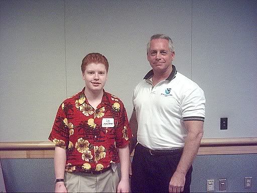
Wonderful discussion by Stacy Stewart. This guy can tell you everything the way it is. I had the pleasure of speaking with him on numerous occasions at the Florida Governor's Hurricane Conference, and even in the conference computer lab...he gave myself, Zack and other members of Radio NHCWX staff a personal thought on the system that would in-part eventually form Eastern Pacific Hurricane Adrian.

This discussion appears that the NHC is currently thinking the potential for Ophelia to loop...and he mentions that "AFTER THAT (96 HOURS) ...MORE STRENGTHENING THAN WHAT IS CURRENTLY FORECAST COULD OCCUR SINCE THE SHEAR IS EXPECTED TO DROP BELOW 10 KT. HOWEVER...THE EXPECTED CLOSE PROXIMITY OF VERY DRY MID-LEVEL AIR PRECLUDES INCREASING THE INTENSITY IN THE LATTER PERIODS AT THIS TIME."

That is rather concerning, given that we could then be looking at a well-defined 80-90 mph hurricane...potentially a strong hurricane threatening the Southeastern USA. Hopefully the Dry Mid-Level air will win out as it did with Irene...if not, the worry is of a potent hurricane coming out of Ophelia.
Image
0 likes   

no advance
Category 1
Category 1
Posts: 413
Joined: Wed Aug 24, 2005 1:50 pm
Location: merritt is.

#2 Postby no advance » Thu Sep 08, 2005 5:31 am

990 is a hurricane.
0 likes   

Anonymous

#3 Postby Anonymous » Thu Sep 08, 2005 5:32 am

no advance wrote:990 is a hurricane.


It's actually 987 mb. It's only a hurricane if winds reach hurricane force.
0 likes   

no advance
Category 1
Category 1
Posts: 413
Joined: Wed Aug 24, 2005 1:50 pm
Location: merritt is.

#4 Postby no advance » Thu Sep 08, 2005 5:34 am

The winds are there somewhere they just have not found them.
0 likes   

Anonymous

#5 Postby Anonymous » Thu Sep 08, 2005 5:43 am

no advance wrote:The winds are there somewhere they just have not found them.


I'd have to disagree with you. Of course...Im sure you would not want a hurricane....I hope

I think Ophelia will be a hurricane by 11pm tonight...the eye is beginning to wrap, but no good eyewall yet.
0 likes   

no advance
Category 1
Category 1
Posts: 413
Joined: Wed Aug 24, 2005 1:50 pm
Location: merritt is.

#6 Postby no advance » Thu Sep 08, 2005 6:00 am

Where do you think it is going to be tonight at 11pm?
0 likes   

Anonymous

#7 Postby Anonymous » Thu Sep 08, 2005 6:04 am

no advance wrote:Where do you think it is going to be tonight at 11pm?


Not far from it's current position.
0 likes   

no advance
Category 1
Category 1
Posts: 413
Joined: Wed Aug 24, 2005 1:50 pm
Location: merritt is.

#8 Postby no advance » Thu Sep 08, 2005 6:12 am

Floydbuster dont put words in my mouth. All I said was the winds are there somewhere. Your a young guy and I watched your videos. I think they NHC should make it more simple and easy to understand. A certain pressure should determine the cat of each storm. I spent alot of time out there fishing and one little plane flying around there is just that. Little.
0 likes   

pavelbure224
S2K Supporter
S2K Supporter
Posts: 132
Age: 42
Joined: Tue Aug 10, 2004 1:50 pm
Location: Sunrise Fl

#9 Postby pavelbure224 » Thu Sep 08, 2005 6:12 am

Floyd
what are your thoughts on Big O and Nate?
0 likes   

Anonymous

#10 Postby Anonymous » Thu Sep 08, 2005 6:22 am

pavelbure224 wrote:Floyd
what are your thoughts on Big O and Nate?


Well...Ophelia, which is a tropical storm....should deepen slowly to steadily over the next 24-72 hours...while meandering off the Florida coast. I think the NHC track is good.

The intensity is difficult. It almost looks similar on radar to concentric eyewall-type features. I think it will become a minimal hurricane either very late tonight or daytime on Friday. However...that is troubling.

If it is a hurricane by tonight, then it could be a powerful hurricane (100 mph) by the time 96 hours rolls around, when more significant deepening can occur. This is very much the scenario that played out during Hurricane Jeanne. One saving grace could be the mid-level dry air that held Irene in check.

Of course, it could stay 60-70 mph for the next 36-48 hours, then become a minimal...then modest Cat 1 by 96-120 hours.

Time will tell with Ophelia.

As for Nate...I think it has peaked...and it should move out and weaken
0 likes   

Anonymous

#11 Postby Anonymous » Thu Sep 08, 2005 6:23 am

no advance wrote:Your a young guy and I watched your videos.


Ok...
0 likes   

User avatar
P.K.
Professional-Met
Professional-Met
Posts: 5149
Joined: Thu Sep 23, 2004 5:57 pm
Location: Watford, England
Contact:

#12 Postby P.K. » Thu Sep 08, 2005 6:44 am

no advance wrote:A certain pressure should determine the cat of each storm.


Not every storm is the same size though.
0 likes   

no advance
Category 1
Category 1
Posts: 413
Joined: Wed Aug 24, 2005 1:50 pm
Location: merritt is.

#13 Postby no advance » Thu Sep 08, 2005 6:50 am

Which NHC forecast? 24hrs ago 48hrs ago? Hey this thing has not moved much. SW movement since yesterday. Pretty soon if this trend keeps up we will be in the west eyewall. Got to get to work. Winds a NW about 20 and it is wet.
0 likes   

User avatar
jasons2k
Storm2k Executive
Storm2k Executive
Posts: 8250
Age: 52
Joined: Wed Jul 06, 2005 12:32 pm
Location: The Woodlands, TX

#14 Postby jasons2k » Thu Sep 08, 2005 8:00 am

no advance wrote: Your a young guy and I watched your videos.


What does THAT have to do with anything? Mike has more knowledge, intuition, maturity, and manners than most people twice his age.
0 likes   

User avatar
senorpepr
Military Met/Moderator
Posts: 12542
Age: 43
Joined: Fri Aug 22, 2003 9:22 pm
Location: Mackenbach, Germany
Contact:

#15 Postby senorpepr » Thu Sep 08, 2005 8:13 am

no advance wrote:A certain pressure should determine the cat of each storm. I spent alot of time out there fishing and one little plane flying around there is just that. Little.


I disagree. The pressure does not dictate the amount of damage that will happen. Small storms with pressures in the 950s will be much more destructive than a large storm with a pressure in the 930s.
0 likes   

User avatar
SouthFloridawx
S2K Supporter
S2K Supporter
Posts: 8346
Age: 47
Joined: Tue Jul 26, 2005 1:16 am
Location: Sarasota, FL
Contact:

#16 Postby SouthFloridawx » Thu Sep 08, 2005 9:12 am

mike would you agree with this synopsis?

southfloridawx2005 wrote:I think florida should be a bit more worried about this one than they were with Katrina. The big O as some call it is sitting out there in the gulf stream and is expected to do so for the next few days. This would give it some time to pick up some proverbial steam from the atlantic and likely give it a chance to strengthen into something to reckon with. In my opinion checking out that radar presentation it is a huge rain maker because it is moving so slow. Anyway keep your eyes on this one and watch your local news.
0 likes   

Josephine96

#17 Postby Josephine96 » Thu Sep 08, 2005 5:09 pm

he forgot to mention Central Florida in his last paragraph about all interests should monitor lol

It says "central and north fla" in the NHC advisories..
0 likes   

Rainband

#18 Postby Rainband » Thu Sep 08, 2005 5:11 pm

Josephine96 wrote:he forgot to mention Central Florida in his last paragraph about all interests should monitor lol

It says "central and north fla" in the NHC advisories..
Seems like the threat to central and south Florida is decreasing with each model run :D
0 likes   

User avatar
wxmann_91
Category 5
Category 5
Posts: 8013
Age: 34
Joined: Fri Jul 15, 2005 2:49 pm
Location: Southern California
Contact:

#19 Postby wxmann_91 » Thu Sep 08, 2005 5:58 pm

senorpepr wrote:
no advance wrote:A certain pressure should determine the cat of each storm. I spent alot of time out there fishing and one little plane flying around there is just that. Little.


I disagree. The pressure does not dictate the amount of damage that will happen. Small storms with pressures in the 950s will be much more destructive than a large storm with a pressure in the 930s.


Not necessarily. Big storms produce bigger damage swaths and more surge. I'd take a small storm over a large fat one making landfall anytime. Of course, how fast the storm is moving also makes a difference.

Nobody can totally and accurately forecast a storm's damage. Some damage by wind (Charley 2004, Andrew 1992), some damage by surge (Ivan 2004, Katrina 2005), some damage by rain (Floyd 1999, Allison 2001), and some damage by tornadoes (Ivan 2004, Beulah 1967). It varies with each storm.
0 likes   

User avatar
jasons2k
Storm2k Executive
Storm2k Executive
Posts: 8250
Age: 52
Joined: Wed Jul 06, 2005 12:32 pm
Location: The Woodlands, TX

#20 Postby jasons2k » Thu Sep 08, 2005 6:05 pm

wxmann_91 wrote:
senorpepr wrote:
no advance wrote:A certain pressure should determine the cat of each storm. I spent alot of time out there fishing and one little plane flying around there is just that. Little.


I disagree. The pressure does not dictate the amount of damage that will happen. Small storms with pressures in the 950s will be much more destructive than a large storm with a pressure in the 930s.


Not necessarily. Big storms produce bigger damage swaths and more surge. I'd take a small storm over a large fat one making landfall anytime. Of course, how fast the storm is moving also makes a difference.

Nobody can totally and accurately forecast a storm's damage. Some damage by wind (Charley 2004, Andrew 1992), some damage by surge (Ivan 2004, Katrina 2005), some damage by rain (Floyd 1999, Allison 2001), and some damage by tornadoes (Ivan 2004, Beulah 1967). It varies with each storm.


Excellent points Wxman!!
0 likes   


Return to “Talkin' Tropics”

Who is online

Users browsing this forum: MetroMike, Wein and 49 guests