Today marks the 44th anniversary of Hurricane Carla.
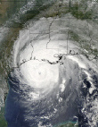
The most powerful tropical system to affect the Texas coast in over 40 years…Hurricane Carla made landfall between Port O’Connor and Port Lavaca on the day of September 11, 1961. In the open waters of the Gulf, a minimum central pressure of 931mb, or 27.50 inches along with maximum sustained wind speeds over 150 mph, made Carla a category 5 hurricane on the Saffir-Simpson scale of hurricane intensity. When the "eye" or center of Hurricane Carla made landfall early in the morning of the 11th, the intensity had dropped off but the storm was still packing winds of 120 mph in areas from Port O’Connor up the coast to Galveston. The "eye" of the storm came within 65 miles to the east of Corpus Christi.
Hurricane warnings were issued along the entire Texas coast on the 9th prompting immediate evacuation of all islands just offshore and low coastal areas. The wind, not the rain, became the major weather factor for the Coastal Bend area. Preliminary wind reports from locations hit hardest by Carla indicated sustained wind speeds of 115 mph in Matagorda…110 mph in Victoria…and 88 mph in Galveston. Peak wind gusts were estimated at 150 mph in Victoria and 170 mph at Port Lavaca! Average wind gusts of 80 to 90 mph were reported across Corpus Christi, with a peak wind of 81 mph recorded at the tower of the Weather Bureau Office, before failure of the instrument.
Rainfall amounts were heaviest from Port Lavaca up the coast to Galveston and within 50 miles inland, ranging from 10 to 16 inches in some spots. Galveston Airport recorded 16.49" of rain in a four-day period. Closer to home, at the airport in Corpus Christi, a relatively light 1.22" fell, but downtown Corpus had 5.15". Victoria recorded a notable 6.25" of rain.
Lowest central pressure recorded at the Corpus airport was 28.88" and at the navy base, 28.73". As the center of the storm passed over Port Lavaca, a calibrated barometer positioned at a dredging company recorded the lowest pressure anywhere on land, with 27.62" before the needle dipped below the reported scale.
With the intense wind, storm surge became a major problem. In some areas from Port Aransas to Sabine Pass, tides were 10 feet above normal…the highest levels since the storm of 1919. One report out of Port Lavaca had a tide level 18.5 feet above normal. The above normal tides produced extensive beach and inland damage to houses and businesses. Over the Corpus Christi area, most of the damage was to roofs, power and telephone lines, trees, and signs. One exception, were low-lying areas, which became flooded from heavy rain and caused more extensive damage. Estimated damage costs exceeded $300 million in Texas, with property losses being the primary contributor. In Nueces County alone, over $12 million in damage was reported from a combination of property damage and severe crop losses.
When it was all said and done, 43 people lost their lives to Hurricane Carla…31 known in the state of Texas.
9/11/61,Anniversary of Hurricane Carla
Moderator: S2k Moderators
Forum rules

The posts in this forum are NOT official forecasts and should not be used as such. They are just the opinion of the poster and may or may not be backed by sound meteorological data. They are NOT endorsed by any professional institution or STORM2K. For official information, please refer to products from the National Hurricane Center and National Weather Service.
9/11/61,Anniversary of Hurricane Carla
Last edited by f5 on Sat Sep 10, 2005 11:44 pm, edited 1 time in total.
0 likes
-
hurricanefreak1988
- Category 3

- Posts: 869
- Joined: Thu Jul 22, 2004 10:13 pm
- Location: Fayetteville, NC
- Contact:
-
cycloneye

- Admin

- Posts: 148822
- Age: 69
- Joined: Thu Oct 10, 2002 10:54 am
- Location: San Juan, Puerto Rico
I Edited the title.
0 likes
Visit the Caribbean-Central America Weather Thread where you can find at first post web cams,radars
and observations from Caribbean basin members Click Here
and observations from Caribbean basin members Click Here
Hurricane Carla began my fascination with weather. I had just started 1st grade. We live on the upper Texas coast and there were preparations being made as our school was closed. I vividly remember the wind and rain coming in surges (rainbands). I remember the hurricane tracking charts we had and waiting for the radio or TV to give the latest coordinates. I would freak out today if we had as little info to go on as we were offered then! We are more than spoiled by today's technology and find ourselves getting impatient to glean even more information from every tropical system out there. Thanks for the blast from the past! 
0 likes

^or people that have lived in Texas for a while...
Sept 8, Galveston hurricane
Sept 11, Hurricane Carla
Another one alot of people I know is April 19, OKC (and Waco). (also the day the American Revolution was begun at the battles at Lexington and Concord in 1775, and in 1943 it was the first day in the Warsaw Ghetto revolt)
Sept 8, Galveston hurricane
Sept 11, Hurricane Carla
Another one alot of people I know is April 19, OKC (and Waco). (also the day the American Revolution was begun at the battles at Lexington and Concord in 1775, and in 1943 it was the first day in the Warsaw Ghetto revolt)
0 likes


-
THead
- S2K Supporter

- Posts: 790
- Joined: Mon Aug 30, 2004 5:09 pm
- Location: Lauderhill, Fla./Jefferson, Ga.
Aslkahuna wrote:Carla was and remains the largest ever storm recorded in the GOM covering the entire Gulf. The peak wind gust was a recorded 172mph gust. Carla was still a Tropical Storm in OK and had TS force winds as an ET Low in MO where heavy rains caused flooding.
Steve
Are there any sat pics of Carla? I know 1961 is in the beginning stages of the space race, not sure if we even had a sat capable of snapping pics yet?
0 likes
-
HurricaneGirl

- Category 5

- Posts: 5839
- Age: 61
- Joined: Thu Feb 06, 2003 9:45 am
- Location: Clare, Michigan
- Contact:
Who is online
Users browsing this forum: No registered users and 141 guests