Hurricane Philippe,Comments,Sat Pics,Models Thread
Moderator: S2k Moderators
-
Florida_TSR
-
Jim Cantore

-
Florida_TSR
-
SkeetoBite

- S2K Supporter

- Posts: 515
- Age: 60
- Joined: Fri Sep 03, 2004 8:25 am
- Contact:
Based on feedback from several users, we have made a few changes to our maps. The line is gone, since it's deceptive. We changed the color scheme to provide better contrast. We will be adding the traditional cone of error and a modified cone soon. The land fall zoom maps will also be modified to match this scheme.
Live data for TD #17 (AL172005)

Many thanks to those who use the thumbnails or save these images elsewhere for use in the forums as this helps us with bandwidth.
Jonathon-
Live data for TD #17 (AL172005)
Many thanks to those who use the thumbnails or save these images elsewhere for use in the forums as this helps us with bandwidth.
Jonathon-
0 likes

Hyperstorm wrote:bvigal...
Please excuse my comment. It wasn't meant toward anyone in particular. It just stated what the pattern is favoring at this time, which is a NW track. I never mentioned NORTH away from the islands. If the scenario plays out this could be a major threat toward the NE islands. There is always the chance of something not following the pattern, but that chance is very small at this time.
Regarding the disclaimer...I read that it is used for people who post a forecast and makes it sound like it is official with predicted strength and location (with Lat/Long).
Hyperstorm, what are your thoughts on if there will be an eventual threat to CONUS? I know it's early but it's never too early to speculate. LOL.
0 likes
665
WHXX04 KWBC 171728
CHGQLM
ATTENTION...NATIONAL HURRICANE CENTER
NCEP COUPLED GFDL HURRICANE MODEL FORECAST MADE FOR
TROPICAL DEPRESSION INVEST 17L
INITIAL TIME 12Z SEP 17
DISCLAIMER ... THIS INFORMATION IS PROVIDED AS GUIDANCE. IT
REQUIRES INTERPRETATION BY HURRICANE SPECIALISTS AND SHOULD
NOT BE CONSIDERED AS A FINAL PRODUCT. PLEASE SEE THE TPC/NHC
OFFICIAL FORECAST.
FORECAST STORM POSITION
HOUR LATITUDE LONGITUDE HEADING/SPEED(KT)
0 12.9 54.9 305./ 8.0
6 13.0 55.1 297./ 3.0
12 13.1 55.2 326./ .3
18 13.6 55.7 318./ 7.8
24 14.0 55.9 333./ 4.1
30 14.6 56.1 337./ 6.9
36 15.2 56.4 337./ 6.1
42 15.6 56.8 309./ 5.7
48 16.1 57.1 327./ 5.6
54 16.7 57.3 343./ 6.2
60 17.2 57.5 336./ 5.6
66 17.7 57.9 330./ 6.1
72 18.5 58.0 347./ 7.8
78 19.2 58.2 343./ 7.1
84 19.8 58.3 354./ 6.0
90 20.4 58.5 340./ 7.0
96 21.1 58.7 350./ 6.8
102 21.8 58.8 350./ 7.2
108 22.3 58.9 353./ 5.4
114 23.0 59.0 350./ 6.9
120 23.8 59.2 343./ 7.8
126 24.4 59.4 344./ 6.8
0 likes
-
SkeetoBite
- S2K Supporter
- Posts: 515
- Age: 60
- Joined: Fri Sep 03, 2004 8:25 am
- Contact:

-
Anonymous

-
apocalypt-flyer
- Category 1

- Posts: 468
- Joined: Sat Aug 27, 2005 11:51 am
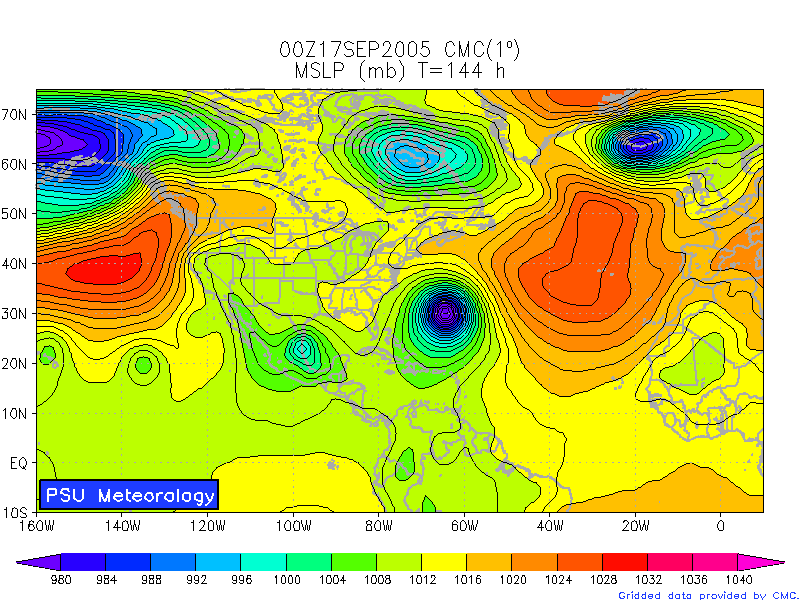
http://moe.met.fsu.edu/cgi-bin/cmctc2.cgi?time=2005091712&field=Sea+Level+Pressure&hour=Animation
Three systems shown by the latest CMC.
Three systems shown by the latest CMC.
0 likes
-
wxmann_91

- Category 5

- Posts: 8007
- Age: 34
- Joined: Fri Jul 15, 2005 2:49 pm
- Location: Southern California
- Contact:
cjrciadt wrote:http://moe.met.fsu.edu/cgi-bin/cmctc2.cgi?time=2005091712&field=Sea+Level+Pressure&hour=Animation
Three systems shown by the latest CMC.
Thankfully 17 is weaker on this run, but ridge is stronger, less chance for fish.
0 likes
Who is online
Users browsing this forum: No registered users and 42 guests