Hurricane Rita - Cat. 5
Moderator: S2k Moderators
-
wxwatcher2

- Category 1

- Posts: 282
- Joined: Mon Sep 06, 2004 4:51 pm
- Location: Central Florida

skysummit wrote:....yea, and people in La. think it'll be an La. hit, people in FL think it'll be a FL hit, people in the Carolinas still think it will turn up the east coast so it's normal for people in Texas to think it'll be a Texas hit. It's just natural like that.
I think it will hit close where NHC and model consensus shows 48 hours from now. I don't think Florida panhandle or Pensacola.
0 likes

-
alahurricane
- Tropical Low

- Posts: 13
- Joined: Wed Jul 13, 2005 8:29 pm
-
Anonymous
-
cycloneye

- Admin

- Posts: 149278
- Age: 69
- Joined: Thu Oct 10, 2002 10:54 am
- Location: San Juan, Puerto Rico
TCUAT3
TROPICAL STORM RITA TROPICAL CYCLONE UPDATE
NWS TPC/NATIONAL HURRICANE CENTER MIAMI FL
910 AM EDT MON SEP 19 2005
...CLARIFICATION OF CUBAN HURRICANE WARNINGS...
A HURRICANE WARNING IS IN EFFECT FOR THE CUBAN PROVINCES OF
VILLA CLARA AND MATANZAS.
A HURRICANE WATCH IS IN EFFECT FOR HABANA AND CIUDAD DE LA
HABANA.
THIS TROPICAL CYCLONE UPDATE SUPERCEDES THE PREVIOUS
CUBAN WARNING INFORMATION CONTAINED IN THE 8 AM EDT
INTERMEDIATE PUBLIC ADVISORY.
FORECASTER STEWART
0 likes
Visit the Caribbean-Central America Weather Thread where you can find at first post web cams,radars
and observations from Caribbean basin members Click Here
and observations from Caribbean basin members Click Here

-
HurricaneGirl

- Category 5

- Posts: 5838
- Age: 61
- Joined: Thu Feb 06, 2003 9:45 am
- Location: Clare, Michigan
- Contact:
-
LAwxrgal

- S2K Supporter

- Posts: 1763
- Joined: Tue Jul 06, 2004 1:05 pm
- Location: Reserve, LA (30 mi west of NOLA)
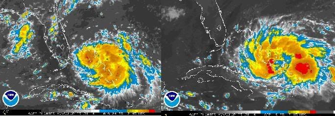
~Floydbuster wrote:KATRINA ON LEFT....RITA ON RIGHT
The Double Trouble Twins...
Rita looks better at this stage of the game than Kat did...unfortunately...what is that dry spot in the center? Is that the eye forming or what?
0 likes
Andrew 92/Isidore & Lili 02/Bill 03/Katrina & Rita 05/Gustav & Ike 08/Isaac 12 (flooded my house)/Harvey 17/Barry 19/Cristobal 20/Claudette 21/Ida 21 (In the Eye)/Francine 24
Wake me up when November ends
Wake me up when November ends
-
Canelaw99

- S2K Supporter
- Posts: 2128
- Age: 49
- Joined: Tue Aug 31, 2004 8:27 am
- Location: Homestead, FL
Max Mayfield, on local CBS, just alluded to the fact that there's a little shift to the north for the next advisory....didn't specify much, but the met asked him "any surprises, any major changes?", and Max said "just a little shift to the north which might put hurricane force winds up this direction"....now, that concerns me, but we'll know for certain when the 11am comes out....
He also reminded everyone that this could be a category 2 by the time it's in the Keys area, so to prepare for a 3 (they recommend preparing for a storm 1 category above their prediction).
He also reminded everyone that this could be a category 2 by the time it's in the Keys area, so to prepare for a 3 (they recommend preparing for a storm 1 category above their prediction).
0 likes
-
tampastorm
- Category 1
- Posts: 434
- Joined: Thu Aug 12, 2004 9:22 pm
- Location: TAMPA
-
x-y-no

- Category 5
- Posts: 8359
- Age: 65
- Joined: Wed Aug 11, 2004 12:14 pm
- Location: Fort Lauderdale, FL
LAwxrgal wrote:~Floydbuster wrote:KATRINA ON LEFT....RITA ON RIGHT
The Double Trouble Twins...
Rita looks better at this stage of the game than Kat did...unfortunately...what is that dry spot in the center? Is that the eye forming or what?
According to recon, the center of circulation is at the very south end of that dry area, just east of the new blob of convection.
I think we'll see this start to wrap around today, with a fairly symetrical system by this evening.
0 likes
-
skysummit

- S2K Supporter
- Posts: 5305
- Age: 50
- Joined: Tue Aug 31, 2004 11:09 pm
- Location: Ponchatoula, LA
- Contact:
To me, it looks as though that gulf high is beginning to retreat a little to the west.
http://weather.cod.edu/analysis/loops/wvrgnlloop.master.pl?us&type=wv
http://weather.cod.edu/analysis/loops/wvrgnlloop.master.pl?us&type=wv
0 likes


-
tracyswfla
- S2K Supporter
- Posts: 792
- Joined: Tue May 18, 2004 1:19 pm
- Location: Rochester, NY
tampastorm wrote:Latest loop still shows a slight north of west movement. Is high pressure suppose to push Rita more to the south, or is this movement staying the same the next 24-36 hours? Makes a huge difference for South Fl.
5am advisory was 22.7N, 74.3W
8am advisory was 22.8 N, 74.6 W
So a little North of West...
0 likes
Who is online
Users browsing this forum: No registered users and 83 guests