http://www.aoml.noaa.gov/phod/dataphod1 ... 5262go.jpg
Should be interesting to see how she maintains her strength. According to this heat content map, there are two comparatively cooler patches of water, as well as the cooler shelf water, that are between Rita and her projected area of landfall.
Also, there's not much talk about the dry air over Texas- anyone think that will have a large effect?
Rita will hit some cooler waters starting tonight ...
Moderator: S2k Moderators
Forum rules

The posts in this forum are NOT official forecasts and should not be used as such. They are just the opinion of the poster and may or may not be backed by sound meteorological data. They are NOT endorsed by any professional institution or STORM2K. For official information, please refer to products from the National Hurricane Center and National Weather Service.

-
arcticfire
- Tropical Storm

- Posts: 189
- Joined: Fri Sep 10, 2004 1:58 am
- Location: Anchorage, AK
- Contact:


Your graphic doesn't provide the proper positioning for Rita- she's almost due south of the Alabama/Florida border now. And I said TONIGHT- in several hours she will be effected by the dark blue patch you see due south of central Louisiana.
http://www.aoml.noaa.gov/phod/dataphod1 ... 5262go.jpg
http://www.aoml.noaa.gov/phod/dataphod1 ... 5262go.jpg
0 likes
-
arcticfire
- Tropical Storm
- Posts: 189
- Joined: Fri Sep 10, 2004 1:58 am
- Location: Anchorage, AK
- Contact:
djtil wrote:yeah dunno where this heading for cooler waters myth came from.
the NHC and computer models.....wouldnt really call it a myth based on multiple NHC discussions making reference to it.
That fine but I have yet to see any charts showing cooler waters in the wgom. Every map I see shows the gom to be largly the same temp. The west being warmer if anything to the east.
0 likes
-
arcticfire
- Tropical Storm
- Posts: 189
- Joined: Fri Sep 10, 2004 1:58 am
- Location: Anchorage, AK
- Contact:
BReb wrote:Your graphic doesn't provide the proper positioning for Rita- she's almost due south of the Alabama/Florida border now. And I said TONIGHT- in several hours she will be effected by the dark blue patch you see due south of central Louisiana.
http://www.aoml.noaa.gov/phod/dataphod1 ... 5262go.jpg
Question , what exactly does TCHP mean? Cause I'm having trouble reading that map.
0 likes

BReb wrote:"The blue on the first map is far deeper water not cooler"
No, that's a model for heat content- you see the bar along the side that talks about kilojoules/ cm2? That's a heat, not depth measurement.
Actually, tropical cyclone heat potential takes into account the depth of the warm water as well, not just sea surface temperatures.
0 likes
-
skysummit

- S2K Supporter

- Posts: 5305
- Age: 50
- Joined: Tue Aug 31, 2004 11:09 pm
- Location: Ponchatoula, LA
- Contact:
BReb wrote:Your graphic doesn't provide the proper positioning for Rita- she's almost due south of the Alabama/Florida border now. And I said TONIGHT- in several hours she will be effected by the dark blue patch you see due south of central Louisiana.
Don't pay attention to the position of Rita. I didn't put it there...it's like that on the website. The map just shows the warmest waters of the gulf are still well west of where Rita is right now.
0 likes
-
arcticfire
- Tropical Storm
- Posts: 189
- Joined: Fri Sep 10, 2004 1:58 am
- Location: Anchorage, AK
- Contact:
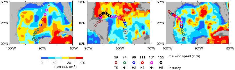
Hmm , from what I'm reading about the chart in question (TCHP) , hot pockets might influince how fast a storm intesifies , but the examples given seem to indicate cooler TCHP does not nessisarly corispond to weakening.
http://www.aoml.noaa.gov/phod/dataphod1/work/HHP/images/HHPOMB.jpg
http://www.aoml.noaa.gov/phod/dataphod1/work/HHP/images/HHPOMB.jpg
0 likes

Who is online
Users browsing this forum: No registered users and 101 guests