Rita Forecasts: #9 (11am Wed): Sabine Pass, TX, 125kt

This is the general tropical discussion area. Anyone can take their shot at predicting a storms path.

Moderator: S2k Moderators

Forum rules

The posts in this forum are NOT official forecasts and should not be used as such. They are just the opinion of the poster and may or may not be backed by sound meteorological data. They are NOT endorsed by any professional institution or STORM2K. For official information, please refer to products from the National Hurricane Center and National Weather Service.

Help Support Storm2K
Message
Author
mtm4319
Category 5
Category 5
Posts: 1537
Joined: Sun Sep 12, 2004 2:47 am
Location: Mobile, AL

Rita Forecasts: #9 (11am Wed): Sabine Pass, TX, 125kt

#1 Postby mtm4319 » Mon Sep 19, 2005 5:11 pm

The following post is NOT an official forecast and should not be used as such. It is just the opinion of the poster and may or may not be backed by sound meteorological data. It is NOT endorsed by any professional institution including storm2k.org For Official Information please refer to the NHC and NWS products.

http://img.photobucket.com/albums/v652/anotherdaybegins/rita/rita01.jpg

Any comments and feedback appreciated. It's my first time trying anything like this, and it'll be fun to see how well I do. :)
Last edited by mtm4319 on Thu Sep 22, 2005 11:00 am, edited 9 times in total.
0 likes   

rainstorm

#2 Postby rainstorm » Mon Sep 19, 2005 5:22 pm

nice work
0 likes   

mtm4319
Category 5
Category 5
Posts: 1537
Joined: Sun Sep 12, 2004 2:47 am
Location: Mobile, AL

#3 Postby mtm4319 » Mon Sep 19, 2005 6:24 pm

I tweaked the map a little bit, adding 60, 84, and 108-hour positions (no change to the 12/24/36/48/72/96/120 hours), and also it should show up a lot more clearly. I also removed the latitude/longitude lines; they were cluttering things up a bit.
0 likes   

mtm4319
Category 5
Category 5
Posts: 1537
Joined: Sun Sep 12, 2004 2:47 am
Location: Mobile, AL

#4 Postby mtm4319 » Mon Sep 19, 2005 10:51 pm

The following post is NOT an official forecast and should not be used as such. It is just the opinion of the poster and may or may not be backed by sound meteorological data. It is NOT endorsed by any professional institution including storm2k.org For Official Information please refer to the NHC and NWS products.

http://img.photobucket.com/albums/v652/anotherdaybegins/rita/rita02.jpg

Forecast #2 is essentially the same as #1: a little more southerly through 72 hours, then a little more northerly after 72 hours, ending up with pretty much the same projected landfall location. Good news for the Keys, though, as I project the path to go south of Key West by about 40-45 miles as opposed with 20 miles on the 5pm advisory. The intensity forecast is essentially the same as well.

The next forecast will hopefully be made at 11am Eastern on Tuesday (but that depends on when I wake up :D).
Last edited by mtm4319 on Tue Sep 20, 2005 4:52 am, edited 1 time in total.
0 likes   

mtm4319
Category 5
Category 5
Posts: 1537
Joined: Sun Sep 12, 2004 2:47 am
Location: Mobile, AL

#5 Postby mtm4319 » Tue Sep 20, 2005 4:52 am

The following post is NOT an official forecast and should not be used as such. It is just the opinion of the poster and may or may not be backed by sound meteorological data. It is NOT endorsed by any professional institution including storm2k.org For Official Information please refer to the NHC and NWS products.

http://img.photobucket.com/albums/v652/anotherdaybegins/rita/rita03.jpg

No significant changes to the track forecast; forecast landfall is only slightly south of the previous forecast. Peak intensity is now 105 kt, down from 110 kt, but landfall intensity remains the same at 105 kt.

12 hours ago, I predicted the center of Rita to be at 23.8 N and 78.5 W in 12 hours, with an intensity of 65 knots. I was off 64 statute miles in position, but only 20 statute miles off in track. My intensity estimate was off by 5 knots; surprisingly, I was actually low on intensity instead of high.

The next forecast is scheduled for 8pm EDT.
Last edited by mtm4319 on Tue Sep 20, 2005 5:03 pm, edited 1 time in total.
0 likes   

User avatar
gboudx
S2K Supporter
S2K Supporter
Posts: 4080
Joined: Thu Sep 04, 2003 1:39 pm
Location: Rockwall, Tx but from Harvey, La

#6 Postby gboudx » Tue Sep 20, 2005 8:25 am

You've got it coming up to pay us a visit in DFW. What's the consensus on this happening? I don't wish the storm on anyone. But if that track verifies, we could get some much needed rain up here.
0 likes   

mtm4319
Category 5
Category 5
Posts: 1537
Joined: Sun Sep 12, 2004 2:47 am
Location: Mobile, AL

#7 Postby mtm4319 » Tue Sep 20, 2005 5:11 pm

The following post is NOT an official forecast and should not be used as such. It is just the opinion of the poster and may or may not be backed by sound meteorological data. It is NOT endorsed by any professional institution including storm2k.org For Official Information please refer to the NHC and NWS products.

http://img.photobucket.com/albums/v652/anotherdaybegins/rita/rita04.jpg

The track forecast is a bit farther south of the previous forecast, but not significantly. The intensity forecast is adjusted upward, but I still expect a slight weakening prior to landfall. Peak intensity is now 115 kt, and forecast landfall intensity is 110 kt.

--------------

24 hours ago, I predicted the center of Rita to be at 24.1 N and 80.5 W in 24 hours, with an intensity of 80 knots. I was off 107 statute miles in position, but only 21 statute miles off in track. My intensity estimate was low by 5 knots.

12 hours ago, I predicted the center of Rita to be at 24.0 N and 82.1 W in 12 hours, with an intensity of 70 knots. I was off just 6 statute miles in position, and less than 1 statute mile off in track. However, my intensity estimate was low by 15 knots.

The next forecast is scheduled for 11pm EDT.
Last edited by mtm4319 on Tue Sep 20, 2005 10:27 pm, edited 1 time in total.
0 likes   

mtm4319
Category 5
Category 5
Posts: 1537
Joined: Sun Sep 12, 2004 2:47 am
Location: Mobile, AL

#8 Postby mtm4319 » Tue Sep 20, 2005 5:13 pm

gboudx wrote:You've got it coming up to pay us a visit in DFW. What's the consensus on this happening? I don't wish the storm on anyone. But if that track verifies, we could get some much needed rain up here.


It looks like a lot of the 18Z models have it coming up near the Dallas area, possibly a bit farther east. It will depend on the direction it's traveling as it goes through Texas, the closer to due north (or east of north), the less chance of a significant rainfall in the Dallas area, but there's still a good chance.
0 likes   

User avatar
hicksta
Category 5
Category 5
Posts: 1108
Age: 35
Joined: Thu Jul 14, 2005 12:16 am
Location: Kemah Texas/ Baton Rogue LA

#9 Postby hicksta » Tue Sep 20, 2005 5:14 pm

I think you are a little south and a little to less on the intesity
0 likes   

dwg71
Category 5
Category 5
Posts: 2349
Joined: Wed Jun 08, 2005 4:34 pm

#10 Postby dwg71 » Tue Sep 20, 2005 5:35 pm

hicksta wrote:I think you are a little south and a little to less on the intesity


REALLY, that's what you think, I would have never guessed.

:lol: Just kidding...keep safe.
0 likes   

mtm4319
Category 5
Category 5
Posts: 1537
Joined: Sun Sep 12, 2004 2:47 am
Location: Mobile, AL

#11 Postby mtm4319 » Tue Sep 20, 2005 10:26 pm

The following post is NOT an official forecast and should not be used as such. It is just the opinion of the poster and may or may not be backed by sound meteorological data. It is NOT endorsed by any professional institution including storm2k.org For Official Information please refer to the NHC and NWS products.

http://img.photobucket.com/albums/v652/anotherdaybegins/rita/rita05.jpg

No major changes in either track or landfall location. Intensity forecast has been bumped slightly; forecast landfall intensity is now 115 knots in 84 hours.

24 hours ago, I predicted the center of Rita to be at 24.0 N and 82.5 W in 24 hours, with an intensity of 85 knots. I was off 45 statute miles in position, but less than 1 statute mile off in track. I forecasted Rita to cross 83.2 W at approximately 24.09 N. My intensity estimate was low by 10 knots.

The next forecast is scheduled for... sometime tomorrow.
Last edited by mtm4319 on Wed Sep 21, 2005 4:38 am, edited 1 time in total.
0 likes   

User avatar
LAwxrgal
S2K Supporter
S2K Supporter
Posts: 1763
Joined: Tue Jul 06, 2004 1:05 pm
Location: Reserve, LA (30 mi west of NOLA)

#12 Postby LAwxrgal » Tue Sep 20, 2005 10:29 pm

Unfortunately...this forecast seems very reasonable and right on line with most of the model guidance and the NHC. God bless Texas. :cry:
0 likes   
Andrew 92/Isidore & Lili 02/Bill 03/Katrina & Rita 05/Gustav & Ike 08/Isaac 12 (flooded my house)/Harvey 17/Barry 19/Cristobal 20/Claudette 21/Ida 21 (In the Eye)/Francine 24
Wake me up when November ends

mtm4319
Category 5
Category 5
Posts: 1537
Joined: Sun Sep 12, 2004 2:47 am
Location: Mobile, AL

#13 Postby mtm4319 » Wed Sep 21, 2005 4:37 am

The following post is NOT an official forecast and should not be used as such. It is just the opinion of the poster and may or may not be backed by sound meteorological data. It is NOT endorsed by any professional institution including storm2k.org For Official Information please refer to the NHC and NWS products.

http://img.photobucket.com/albums/v652/anotherdaybegins/rita/rita06.jpg

Still no significant changes to track or landfall location. After traveling south of the points I made for my forecast 36 hours ago, the actual track is heading back toward that line. I remain faithful on track/landfall (near Matagorda, TX), but I keep edging upward in intensity. I now have a peak of intensity of 130 kt (an increase of 10 knots since my last forecast), but don't feel confident enough yet in increasing forecasted landfall intensity by the same amount. Therefore the projected landfall intensity is 120 kt, still a category 4.

12 hours ago, I predicted the center of Rita to be at 24.3 N and 84.6 W in 12 hours, with an intensity of 95 knots. I was exactly right in both position and track! What can I say? Beginner's luck, I guess. However, my intensity estimate was low by 10 knots.

24 hours ago, I predicted the center of Rita to be at 24.2 N and 84.5 W in 24 hours, with an intensity of 80 knots. I was off just 9 statute miles in position, and 6 statute miles off in track. However, my intensity estimate was low by a whopping 25 knots.

36 hours ago, I predicted the center of Rita to be at 24.4 N and 83.0 W in 36 hours, with an intensity of 80 knots. I was off 101 statute miles in position, but only 12 statute miles off in track. Also, my intensity estimate was low by 15 knots.

The next forecast is scheduled for 5pm EDT today.
Last edited by mtm4319 on Wed Sep 21, 2005 4:55 pm, edited 1 time in total.
0 likes   

mtm4319
Category 5
Category 5
Posts: 1537
Joined: Sun Sep 12, 2004 2:47 am
Location: Mobile, AL

#14 Postby mtm4319 » Wed Sep 21, 2005 4:55 pm

The following post is NOT an official forecast and should not be used as such. It is just the opinion of the poster and may or may not be backed by sound meteorological data. It is NOT endorsed by any professional institution including storm2k.org For Official Information please refer to the NHC and NWS products.

http://tinypic.com/dwt7w2.jpg

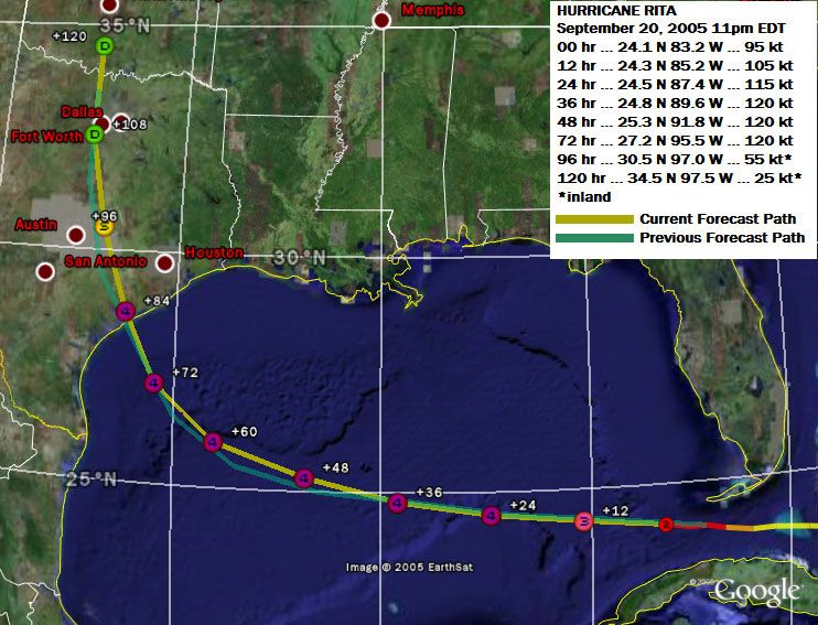
The landfall location has been moved 15-20 miles northeast of the previous forecast, but that is only circumstantial - a result of attempting to forecast positions on whole or half degrees at 72 hours and beyond. The total range of projected landfall locations from advisory 1 to advisory 7 is 38 miles. Long story short: I'm sticking with my Matagorda projection for now.

Intensity forecast takes it to a 150-knot peak in 12 hours, followed by slow weakening thereafter. Landfall is still projected at category-4 intensity, and at a 10-knot increase from my previous forecast.

============================================

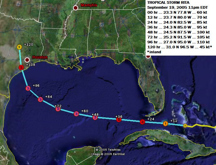
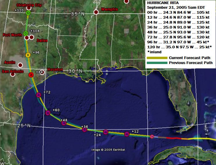
12 hours ago, I predicted the center of Rita to be at 24.6 N and 87.0 W in 12 hours, with an intensity of 115 knots. I was off just 19 statute miles in position, and 12 statute miles off in track. However, my intensity estimate was low by a whopping 30 knots.

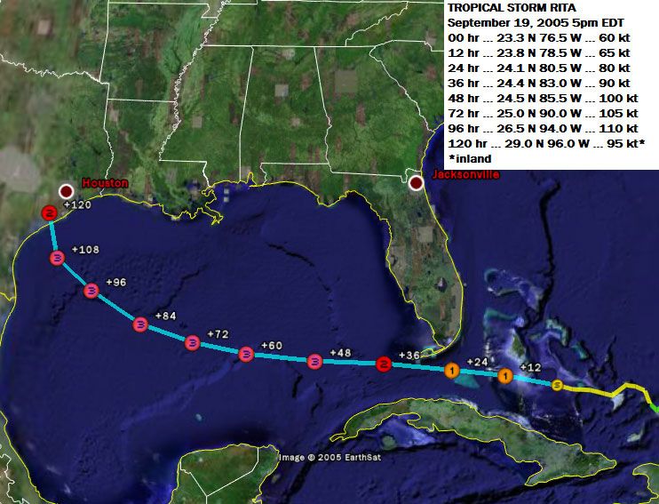
24 hours ago, I predicted the center of Rita to be at 24.5 N and 87.0 W in 12 hours, with an intensity of 105 knots. I was off just 14 statute miles in position, and 6 statute miles off in track. However, my intensity estimate was low by a ridiculous 40 knots.

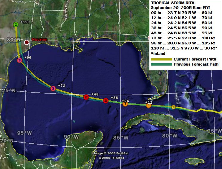
36 hours ago, I predicted the center of Rita to be at 24.5 N and 86.5 W in 12 hours, with an intensity of 90 knots. I was off just 20 statute miles in position, and 10 statute miles off in track. However, my intensity estimate was low by an astronomical 55 knots.

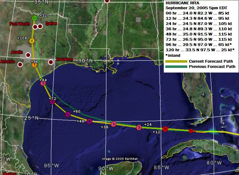
48 hours ago, I predicted the center of Rita to be at 24.5 N and 85.5 W in 12 hours, with an intensity of 100 knots. I was off 82 statute miles in position, but only 14 statute miles off in track. However, my intensity estimate was low by an astounding 45 knots.

==============================================

The next forecast is scheduled for 10pm CDT.
Last edited by mtm4319 on Wed Sep 21, 2005 10:25 pm, edited 1 time in total.
0 likes   

User avatar
amawea
S2K Supporter
S2K Supporter
Posts: 385
Age: 73
Joined: Mon Aug 09, 2004 3:36 pm
Location: Horseshoe Bend, Ar. but from Baytown, Tx

#15 Postby amawea » Wed Sep 21, 2005 5:01 pm

Hey MTM, that looks like a Google Global. My Global isn't showing that. Can you help?
Amawea
0 likes   

mtm4319
Category 5
Category 5
Posts: 1537
Joined: Sun Sep 12, 2004 2:47 am
Location: Mobile, AL

#16 Postby mtm4319 » Wed Sep 21, 2005 5:06 pm

amawea wrote:Hey MTM, that looks like a Google Global. My Global isn't showing that. Can you help?
Amawea


I'm not sure what you mean by a "Google Global", but I am using Google Earth. Can you elaborate?
0 likes   

mtm4319
Category 5
Category 5
Posts: 1537
Joined: Sun Sep 12, 2004 2:47 am
Location: Mobile, AL

#17 Postby mtm4319 » Wed Sep 21, 2005 10:24 pm

The following post is NOT an official forecast and should not be used as such. It is just the opinion of the poster and may or may not be backed by sound meteorological data. It is NOT endorsed by any professional institution including storm2k.org For Official Information please refer to the NHC and NWS products.

http://tinypic.com/dwxn43.jpg

I'm going just slightly more conservative on track (a bit farther away from Houston than the NHC's forecast, but still a touch farther east than my 5pm advisory) and intensity (still taking it down to 130 knots at landfall, but I debated between 130 and 135 knots) than I could at this point.

I'm kind of tired right now (very little sleep) so I'll keep it at that.

The next advisory is scheduled for 11am EDT tomorrow.
Last edited by mtm4319 on Thu Sep 22, 2005 11:01 am, edited 1 time in total.
0 likes   

mtm4319
Category 5
Category 5
Posts: 1537
Joined: Sun Sep 12, 2004 2:47 am
Location: Mobile, AL

#18 Postby mtm4319 » Thu Sep 22, 2005 10:59 am

Image

Overnight, my first 8 forecasts were rendered basically worthless. A significant northward shift has occurred, and I have shifted projected landfall location accordingly to near the TX/LA state line.

A significant weakening trend (16 millibars in less than 12 hours) has also occurred. This appears to be the result of both the sheer difficulty of maintaining a sub-900mb hurricane for longer than a few hours, and an eyewall reconfiguration cycle. The potential exists for Rita to fall below category 4 intensity; however, I'll maintain category 4 for landfall because the maximum potential intensity for the TX/LA coast area is the highest in the entire Gulf. Note that Rita simply could not stay below 900mb even if there were no dry air, shear, etc.

The next forecast is scheduled for 11pm EDT.
0 likes   


Return to “Talkin' Tropics”

Who is online

Users browsing this forum: duilaslol, Google [Bot], Teban54 and 198 guests