I know Camille supposedly did it though 190mph sounds way too high. It'll probably come down on re-analysis.
But with the Continental dry air, shallow waters and loss of heat content, add in unpredictable shear and eyewall replacement cycles, it seems a Cat 5 landfalling Hurricane is climatologically impossible on the Florida Panhandle through the Texas coast.
It seems climatologically a Cat 4 is the upper limit in most cases. I'd be curious to know what made Camille so unique.
Rita is pooping out as we speak because of dry air. Recon can't find winds higher than 125mph and the NHC advisory of 135mph is very generous. It'll probably landfall at a borderline Cat2/3 or 115mph.
How is a landfalling Cat 5 possible in the Gulf?
Moderator: S2k Moderators
Forum rules

The posts in this forum are NOT official forecasts and should not be used as such. They are just the opinion of the poster and may or may not be backed by sound meteorological data. They are NOT endorsed by any professional institution or STORM2K. For official information, please refer to products from the National Hurricane Center and National Weather Service.
-
Rainband
Re: How is a landfalling Cat 5 possible in the Gulf?
logybogy wrote:I know Camille supposedly did it though 190mph sounds way too high. It'll probably come down on re-analysis.
But with the Continental dry air, shallow waters and loss of heat content, add in unpredictable shear and eyewall replacement cycles, it seems a Cat 5 landfalling Hurricane is climatologically impossible on the Florida Panhandle through the Texas coast.
It seems climatologically a Cat 4 is the upper limit in most cases. I'd be curious to know what made Camille so unique.
Rita is pooping out as we speak because of dry air. Recon can't find winds higher than 125mph and the NHC advisory of 135mph is very generous. It'll probably landfall at a borderline Cat2/3 or 115mph.
I'm not sure it's ever been possible. Is there any hard evidence that Camille was a category 5 at landfall? Sure the surge was huge, but we saw that from Katrina, which supposedly landfalled in Mississippi (second landfall) as a cat 3 (with 922 mb pressure or something) and had a surge larger than Camille's. So we can't base her cat 5 distinction on surge height.
Nor can we base it on central pressure at landfall. Sure she came in at 909 mb (estimated), but yesterday Rita was spinning over the Gulf with 913 mb, and aircraft couldn't find flight level winds that justified anything more than 135 mph at the surface. So we can't base Camille's cat 5 on pressure.
Is there any evidence of actual wind damage caused by Camille that a) was worse than what Katrina caused in the same area, and b) suggest cat 5 winds at landfall?
I think it's an uphill battle for a hurricane to even make landfall along the Gulf coast as a cat 4. It's a losing battle once they get above 26N it seems. Then the question becomes how quickly can the storm get ashore to minimize the weakening. Katrina, for example, was experiencing massive degradation but was able to make it ashore before it got to Rita's current state.
I posted a topic before this year's hurricane season with the subject of something like "Do northward moving hurricanes inevitably weaken when hitting the N Gulf coast?" I think that's being proven true.
Last edited by tallywx on Fri Sep 23, 2005 12:32 pm, edited 1 time in total.
0 likes
-
superfly
Re: How is a landfalling Cat 5 possible in the Gulf?
logybogy wrote:I know Camille supposedly did it though 190mph sounds way too high. It'll probably come down on re-analysis.
But with the Continental dry air, shallow waters and loss of heat content, add in unpredictable shear and eyewall replacement cycles, it seems a Cat 5 landfalling Hurricane is climatologically impossible on the Florida Panhandle through the Texas coast.
It seems climatologically a Cat 4 is the upper limit in most cases. I'd be curious to know what made Camille so unique.
Rita is pooping out as we speak because of dry air. Recon can't find winds higher than 125mph and the NHC advisory of 135mph is very generous. It'll probably landfall at a borderline Cat2/3 or 115mph.
Camille was a very fast moving storm and reached her peak intensity right off the coast as opposed to Katrina and Rita who peaked in the middle of the Gulf.
0 likes
-
inotherwords
- Category 2

- Posts: 773
- Joined: Mon Aug 30, 2004 9:04 pm
- Location: Nokomis, FL
If a storm entered the Gulf and became a Cat. 5 a couple hundred miles off the west coast of FL it could very easily hook a hard right into the coast before it has the chance to burn out, and hit as a Cat 5.
This is a nightmare scenario for me and most of the rest of us on this coast, especially this time of year and in Oct. when storms tend to behave that way trackwise and when the Gulf is still very warm. Not only would we get the intensity, we would not have a lot of time to get out of the way.
This is a nightmare scenario for me and most of the rest of us on this coast, especially this time of year and in Oct. when storms tend to behave that way trackwise and when the Gulf is still very warm. Not only would we get the intensity, we would not have a lot of time to get out of the way.
0 likes
-
ColinDelia

- S2K Supporter

- Posts: 918
- Joined: Mon Aug 29, 2005 5:52 am
- Location: The Beach, FL
Re: How is a landfalling Cat 5 possible in the Gulf?
tallywx wrote: Is there any hard evidence that Camille was a category 5 at landfall?
Pressure of 26.84 inches. Bay St. Louis, Mississippi
0 likes

"Is there any hard evidence that Camille was a category 5 at landfall?"
This of course isn't hard evidence, but there is some video footage of Camille making landfall, in particular, a shot of a sturdy little palm tree absolutely being bent over by the storm. I've seen enough footage from tv reporters in hurricanes to know that the winds depicted in that video are an order of magnitude greater than any storm I've seen in my lifetime. Camille had the winds big time- she just wasn't big enough to push the same amount of water as Katrina.
This of course isn't hard evidence, but there is some video footage of Camille making landfall, in particular, a shot of a sturdy little palm tree absolutely being bent over by the storm. I've seen enough footage from tv reporters in hurricanes to know that the winds depicted in that video are an order of magnitude greater than any storm I've seen in my lifetime. Camille had the winds big time- she just wasn't big enough to push the same amount of water as Katrina.
0 likes
-
donsutherland1
- S2K Analyst

- Posts: 2718
- Joined: Mon Sep 15, 2003 8:49 pm
- Location: New York
Re: How is a landfalling Cat 5 possible in the Gulf?
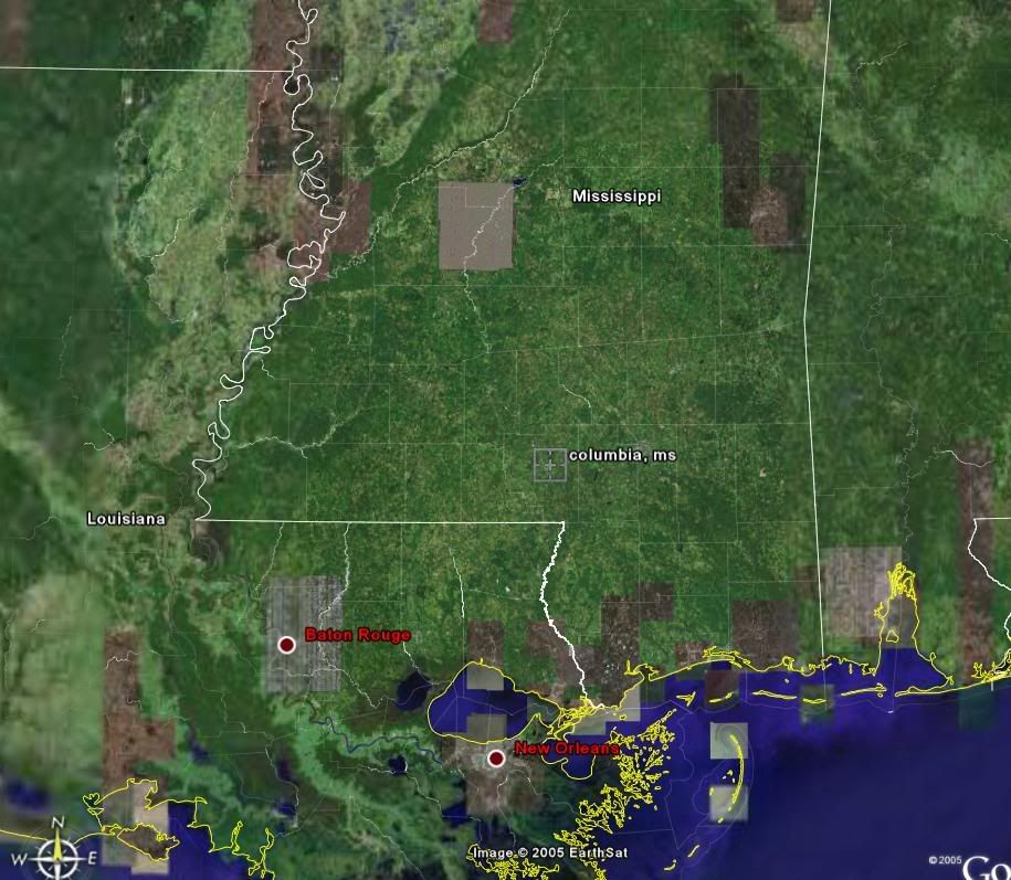
Aside from many of the wind damage (as opposed to storm surge damage) assessments that suggested Cat. 5 winds, a report from one of the wind instruments near Camille's path implied Cat. 5 winds.
At Columbia, MS, some 3 hours after Camille had made landfall, an anemometer recorded sustained winds of 120 mph before it was destroyed. Columbia is inland approximately 70 miles north-northwest of where Camille made landfall.
If one examines Hurricane Andrew for a proxy, one finds that between 25.5N 80.3W to 25.6N 81.2W, Andrew's top winds dropped from 165 mph to 130 mph. That's a distance of just over 56.5 miles.
If one assumes just a straight-line weakening, that would infer that Camille's winds would have diminished by about 40 mph. So, at a minimum, one would be talking about a 160 mph landfalling hurricane.
However, two factors suggest that Camille was likely stronger:
1) Andrew's circulation was heading back over water before it reached 25.6N 81.2W. Camille's was heading ever farther inland. Hence, one reasonably could have assumed that Andrew's figures suggested better conservation of strength than one could have expected from Camille because its circulation was heading back over water.
2) The wind instrument was destroyed when sustained winds reached 120 mph. This allows for the possibility of perhaps a somewhat higher sustained wind.
All said, I believe that one can have high confidence in the idea that Camille made landfall as a Category 5 hurricane and I have very little doubt that the Re-Analysis will reaffirm that.
Finally, FWIW, the "Indianola Hurricane" (1886) made Texas landfall with maximum sustained winds of 155 mph. That was just under Cat. 5 strength, which begins at 156 mph. Hence, in rare cases, Cat. 5 hurricanes certainly are possible in the northern and western Gulf of Mexico.
0 likes


I think it is just that Landfalling category 5 storms are very rare events. There are still only 3 known landfalling category 5 hurricanes in the United States.... The Labor Day storm of 1935, Camille, and Andrew. Also it is important to remember that storms are unable to sustain that strength for very long and everything has to come together for intensification as the storm is closing in on the coast, similar to Charley but it doesn't necessarily have to be that close. Or as mentioned above, a fast mover such as Camille.
0 likes

-
Downdraft

- S2K Supporter
- Posts: 906
- Joined: Wed Oct 09, 2002 8:45 pm
- Location: Sanford, Florida
- Contact:
I think people place to much importance on the winds generated by a tropical cyclone. In fact, the dissipation of heat energy is by far more a product of rainfall. We tend to snicker at people saying it's "only" a tropical storm or a catergory one hurricane. Well, Allison was only a tropical storm and flooded out Houston. A TC sitting on top of someone for 2 or 3 days and dissipating itself through rainfall is just as much a nightmare scenario as 140 mph winds raking the coast. Remember Floyd in the Carolinas? Inland flooding created most of the damage. The same holds true for Agnes in the mid-Atlantic states. Without a doubt the greatest cause of damage of the widest area is the rain generated. If you doubt me read some of the papers done by Chris Landsea available through the NHC's website.
0 likes
I'm sure that dry air, though often present, isn't *always* over Texas, LA, and the FL Panhandle. I'd also wager that certain years see water warm enough to sustain a Cat. 5 nudging closer to the coast.
It's not possible to know, but I'd bet Camille had at least one of those things working in her favor.
Cat. 5 landfalls are somewhat rare....any way you slice it. What coastline in the Atlantic basin would you all say has the best chance of being hit by a Cat. 5? This is how I would guess, in order of likelihood:
1. Yucatan Peninsula
2. Cuba
3. Lesser Antilles
4. Puerto Rico
5. Hispaniola
6. Bahamas
7. S. FL/FL Keys
Have any studies been done on this? I would have to imagine that the Florida peninsula is the most likely place in the US to see a Cat. 5 landfall, due to the typical lack of continental dry air in the summer and fall months, and warm water right up to the coastline.
0 likes
-
AL Chili Pepper

- Category 3

- Posts: 873
- Joined: Thu Aug 12, 2004 1:15 pm
- Location: Mobile, AL
Radar pictures from the time Camille was nearing the coast showed a tight little eyewall. Herbert Saffir himself described the catastropic damage he witnessed well away from the coast. Camille may not have been 190, but IMO was no less than 175-180.
Interesting thing I ran across on the web that I didn't know. John Hope worked at the NHC in 1969, and named Camille after his daughter that had just graduated high school.
Interesting thing I ran across on the web that I didn't know. John Hope worked at the NHC in 1969, and named Camille after his daughter that had just graduated high school.
0 likes

Another thing that I think would tend to work against a landfall as a Cat 5 is that the hurricane isn't considered to have made landfall until the center if her eye is on land. So the storm may have brought her surge to land, and some of her strongest winds but not considered to have made landfall yet (if she's weakening as she goes into land she may drop a cat before the middle of her eye is on shore, even though she's hit things on shore with 156+ sustained winds.)
0 likes
Who is online
Users browsing this forum: Google Adsense [Bot] and 100 guests