99L Invest,Comments,Sat Pics,Models Thread

This is the general tropical discussion area. Anyone can take their shot at predicting a storms path.

Moderator: S2k Moderators

Forum rules

The posts in this forum are NOT official forecasts and should not be used as such. They are just the opinion of the poster and may or may not be backed by sound meteorological data. They are NOT endorsed by any professional institution or STORM2K. For official information, please refer to products from the National Hurricane Center and National Weather Service.

Help Support Storm2K
Message
Author
User avatar
cajungal
Category 5
Category 5
Posts: 2336
Age: 49
Joined: Sun Mar 14, 2004 9:34 pm
Location: Schriever, Louisiana (60 miles southwest of New Orleans)

#281 Postby cajungal » Mon Sep 26, 2005 2:49 pm

Everyone calm down. Nothing has developed yet.
0 likes   

Opal storm

#282 Postby Opal storm » Mon Sep 26, 2005 2:51 pm

I think this will be a threat to the central/eastern Gulf coast.I don't see this going to Texas.
0 likes   

User avatar
gatorcane
S2K Supporter
S2K Supporter
Posts: 23703
Age: 47
Joined: Sun Mar 13, 2005 3:54 pm
Location: Boca Raton, FL

#283 Postby gatorcane » Mon Sep 26, 2005 2:52 pm

If a S. Florida track verified and assuming this develops into a hurricane or T.S., what time frame are we talking about as far as when S. Florida would feel impacts?
0 likes   

User avatar
Tampa Bay Hurricane
Category 5
Category 5
Posts: 5598
Age: 37
Joined: Fri Jul 22, 2005 7:54 pm
Location: St. Petersburg, FL

#284 Postby Tampa Bay Hurricane » Mon Sep 26, 2005 2:53 pm

Can someone provide more information on that cold front
expected to dig down...such as when it digs into the GOM...etc??
Last edited by Tampa Bay Hurricane on Mon Sep 26, 2005 2:53 pm, edited 1 time in total.
0 likes   

User avatar
cajungal
Category 5
Category 5
Posts: 2336
Age: 49
Joined: Sun Mar 14, 2004 9:34 pm
Location: Schriever, Louisiana (60 miles southwest of New Orleans)

#285 Postby cajungal » Mon Sep 26, 2005 2:53 pm

I don't see this being a threat to LA/or TX. I will eat my words if anything changes. But, we will have 2 fronts coming down back to back and it should protect both TX or LA. I am not concerned right now. It may not even develop at all. I am addicted to this site, so that is why I am on almost every single day.
0 likes   

User avatar
Tampa Bay Hurricane
Category 5
Category 5
Posts: 5598
Age: 37
Joined: Fri Jul 22, 2005 7:54 pm
Location: St. Petersburg, FL

#286 Postby Tampa Bay Hurricane » Mon Sep 26, 2005 2:53 pm

cajungal wrote:I don't see this being a threat to LA/or TX. I will eat my words if anything changes. But, we will have 2 fronts coming down back to back and it should protect both TX or LA. I am not concerned right now. It may not even develop at all. I am addicted to this site, so that is why I am on almost every single day.


When will the two fronts hit the GOM?
0 likes   

User avatar
Canelaw99
S2K Supporter
S2K Supporter
Posts: 2128
Age: 49
Joined: Tue Aug 31, 2004 8:27 am
Location: Homestead, FL

#287 Postby Canelaw99 » Mon Sep 26, 2005 2:54 pm

boca_chris wrote:If a S. Florida track verified and assuming this develops into a hurricane or T.S., what time frame are we talking about as far as when S. Florida would feel impacts?


Looks like it would be end of the week - Thurs. or so from what I see on the models.
0 likes   

User avatar
deltadog03
Professional-Met
Professional-Met
Posts: 3580
Joined: Tue Jul 05, 2005 6:16 pm
Location: Macon, GA

#288 Postby deltadog03 » Mon Sep 26, 2005 2:55 pm

first front is tonight or tom....the 2nd one will be on wed night....folks these fronts will be long gone by time this, whatever form its in, approaches the gulf
0 likes   

caneman

#289 Postby caneman » Mon Sep 26, 2005 2:55 pm

rainstorm wrote:model shows the biggest ridge of the year. if anything does develop it will head to tx/la

http://moe.met.fsu.edu/cgi-bin/gfstc2.c ... hour=144hr


This is 144 hours out though. Models have it in the keys in the 5 days which seems more likely. I personally think it will in the keys in 96 unless some serious slowing down tkaes place.
0 likes   

User avatar
Tampa Bay Hurricane
Category 5
Category 5
Posts: 5598
Age: 37
Joined: Fri Jul 22, 2005 7:54 pm
Location: St. Petersburg, FL

#290 Postby Tampa Bay Hurricane » Mon Sep 26, 2005 2:55 pm

Why do the models have it moving so slowly? Its moving at
17.25 mph (15 KT) that is a lot faster than the time tables the models
give.
0 likes   

User avatar
Tampa Bay Hurricane
Category 5
Category 5
Posts: 5598
Age: 37
Joined: Fri Jul 22, 2005 7:54 pm
Location: St. Petersburg, FL

#291 Postby Tampa Bay Hurricane » Mon Sep 26, 2005 2:56 pm

deltadog03 wrote:first front is tonight or tom....the 2nd one will be on wed night....folks these fronts will be long gone by time this, whatever form its in, approaches the gulf

I thought I read a discussion out of LA of a front arriving Friday...??
0 likes   

flhurricaneguy
Tropical Storm
Tropical Storm
Posts: 197
Joined: Mon Sep 26, 2005 10:21 am

#292 Postby flhurricaneguy » Mon Sep 26, 2005 2:57 pm

what does it develop it as when it enters the keys?
0 likes   

User avatar
TSmith274
S2K Supporter
S2K Supporter
Posts: 756
Joined: Thu Sep 09, 2004 1:11 am
Location: New Orleans, La.

#293 Postby TSmith274 » Mon Sep 26, 2005 2:58 pm

GOM SST's should be about tapped out, right? Maybe one of you more learned individuals can fill me in here.
0 likes   

User avatar
deltadog03
Professional-Met
Professional-Met
Posts: 3580
Joined: Tue Jul 05, 2005 6:16 pm
Location: Macon, GA

#294 Postby deltadog03 » Mon Sep 26, 2005 2:58 pm

yeah, its moving through late wed or thursday morn here.....thursday is suppose to be cooler here in N TX
0 likes   

AZS
Tropical Storm
Tropical Storm
Posts: 117
Joined: Sun Sep 18, 2005 5:50 pm
Location: PD, Azores Islands, Portugal

#295 Postby AZS » Mon Sep 26, 2005 2:58 pm

Image
0 likes   

caneman

#296 Postby caneman » Mon Sep 26, 2005 3:00 pm

TSmith274 wrote:GOM SST's should be about tapped out, right? Maybe one of you more learned individuals can fill me in here.


No not tapped. Shear would be more of a problem.
0 likes   

User avatar
sweetpea
S2K Supporter
S2K Supporter
Posts: 858
Age: 58
Joined: Fri Jun 10, 2005 5:49 pm
Location: Sopchoppy, FL

#297 Postby sweetpea » Mon Sep 26, 2005 3:02 pm

cycloneye wrote:Image

Look at LBAR how it tracks thru I 95 to near Jacksonville.I know that HG will say her famous words as she lives there when she see this. :)


Yeah that pretty much puts it right over my head. I hope the whole thing just goes away. LBAR usually isn't right anyway? right?
0 likes   

Stratosphere747
Category 5
Category 5
Posts: 3772
Joined: Thu Sep 11, 2003 8:34 pm
Location: Surfside Beach/Freeport Tx
Contact:

#298 Postby Stratosphere747 » Mon Sep 26, 2005 3:02 pm

TSmith274 wrote:GOM SST's should be about tapped out, right? Maybe one of you more learned individuals can fill me in here.


Not quite...The NW Carribean is about as hot as it has been all year. Fully recovered since Emily. Parts of the GOM have been untouched.

I'll dig up some more charts, but towards the Lower Tx coast is plenty hot...

http://www.fintalk.com/resources/sst/gu ... exlow.html
0 likes   

CHRISTY

#299 Postby CHRISTY » Mon Sep 26, 2005 3:02 pm

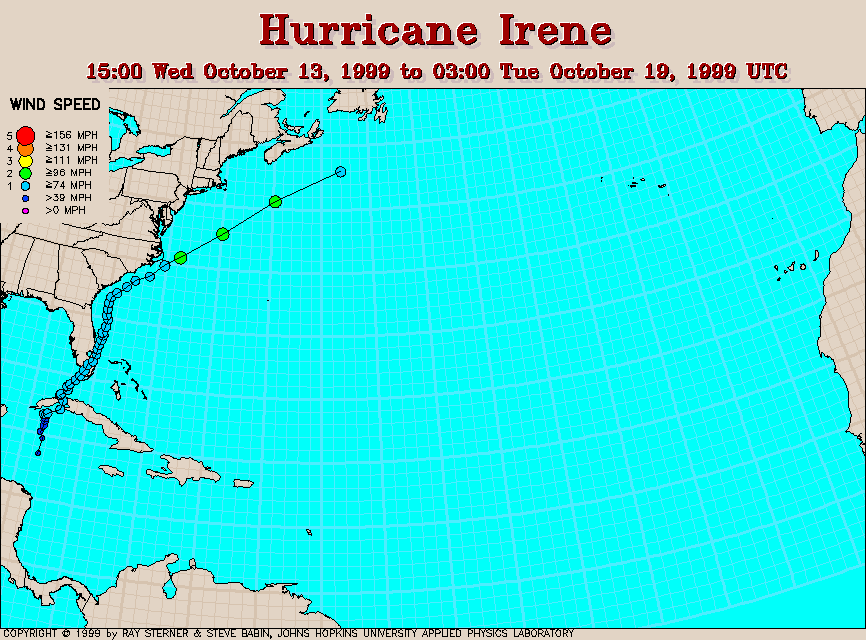
i think the front thats coming will pull this system towards south florida! kinda like a hurricane irene senerio! ImageImage
0 likes   

User avatar
skysummit
S2K Supporter
S2K Supporter
Posts: 5305
Age: 49
Joined: Tue Aug 31, 2004 11:09 pm
Location: Ponchatoula, LA
Contact:

#300 Postby skysummit » Mon Sep 26, 2005 3:03 pm

sweetpea wrote:Yeah that pretty much puts it right over my head. I hope the whole thing just goes away. LBAR usually isn't right anyway? right?


Nope.
0 likes   


Return to “Talkin' Tropics”

Who is online

Users browsing this forum: Hurricane2022, Teban54 and 54 guests