92L Invest,Comments,Sat Pics,Models Thread
Moderator: S2k Moderators
Forum rules

The posts in this forum are NOT official forecasts and should not be used as such. They are just the opinion of the poster and may or may not be backed by sound meteorological data. They are NOT endorsed by any professional institution or STORM2K. For official information, please refer to products from the National Hurricane Center and National Weather Service.
-
CHRISTY
-
Air Force Met
- Military Met

- Posts: 4372
- Age: 57
- Joined: Tue Jul 08, 2003 9:30 am
- Location: Roan Mountain, TN
CHRISTY wrote:look at the satilite loop i posted whats up with that deep red fireing up?
You need three things to get deep convection in the tropics:
1) Low level convergence (present)
2) Upper level divergence (present)
3) Lots of moist air throughout the atmosphere (present)
Just because thunderstorms blossom doesn't mean there is major development occuring, especially since the kinds of divergence occuring over 92L right now is hostile for development. yeah...it provides for upward vertical motion...but it transports the energy away from the system too quickly...and there is no anticyclone aloft. Could a TD be forming? Certainly...but let's be honest...right now a TD is really no big deal and won't really change what anyone recieves....they will still get the same weather.
0 likes
-
Tampa Bay Hurricane

- Category 5

- Posts: 5597
- Age: 38
- Joined: Fri Jul 22, 2005 7:54 pm
- Location: St. Petersburg, FL
-
CHRISTY
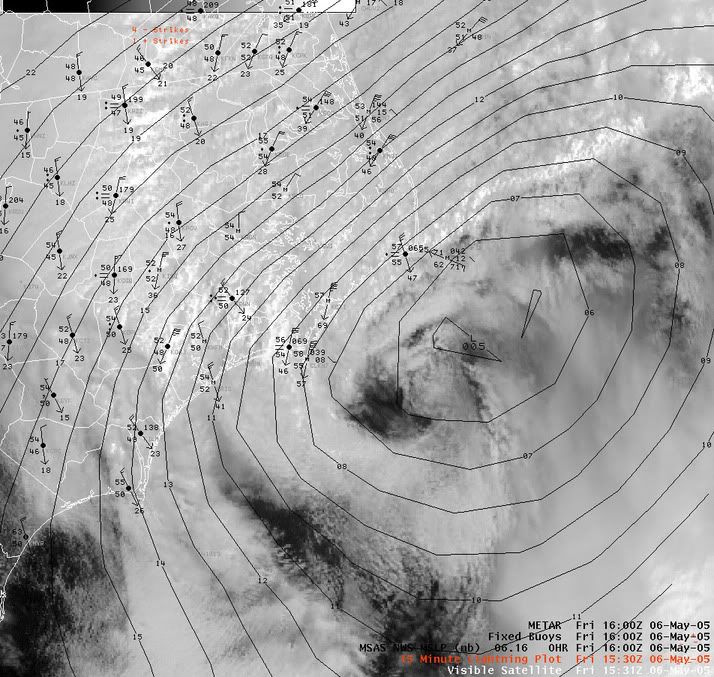 iam not saying this is gonna happen but here's a close up image of a hybrid cyclone!

Air Force Met wrote: You have to be careful and not let enthusiasm cloud your judgment of the facts.
Definitely has a healthy helping of enthusiasm. Now, if Air Force Met can just get Christy to regulate the aforesaid enthusiasm. But as our secretary of defense said about Iraq, " It will be a long hard slog."
Last edited by joseph01 on Tue Oct 04, 2005 4:39 pm, edited 1 time in total.
0 likes

CHRISTY wrote:none of the precip is reaching the ground.
Weather here has been similar to what we get when a Tropical system is coming in; like it was in Palm Beach County for Katrina and Rita.
Brief squalls with gusts and heavy rain for about 5-10 minutes.
They come periodically and ARE hitting the ground!
Today the clouds are much thicker although we have had this pattern for a couple of days now.
Also similar to the genesis of Ophelia when the Depression formed off of our coast Labor Day weekend.
Not to compare the future of this system to any of the aforementioned named systems just comparing the conditions here where I live.
0 likes

Brent wrote:A form of the ETA model??? Not sure...
WSETA is an acronym for WorkStation ETA. It is my understanding it is a model used at the NWS Office in Tampa and I am sure at other NWS offices. See below:
000
FXUS62 KTBW 031730
AFDTBW
WEST CENTRAL AND SOUTHWEST FLORIDA FORECAST DISCUSSION
NATIONAL WEATHER SERVICE TAMPA BAY AREA - RUSKIN FL
130 PM EDT MON OCT 3 2005
...WET WEATHER STILL EXPECTED BUT WHERE WHEN AND HOW MUCH STILL TO BE
DETERMINED...
.SHORT TERM (TONIGHT-WED)...TROPICAL WAVE EAST OF THE CENTRAL
BAHAMAS IS TAKING ITS TIME GETTING TO US. MODELS HAD INITIALLY
DEPICTED WAVE PASSAGE MON NIGHT INTO TUE...BUT NOW IT SEEMS THAT
WE`LL START SEEING THE RAIN AHEAD OF THE WAVE TUE AFTN. OUR
LOCAL TROPICAL WORKSTATION ETA RUN FROM LAST NIGHT (00Z/OCTOBER 3)
EVEN HAS THE LOW DEVELOPING INTO A TC BUT HANGING OFF THE EAST COAST
OF FL BEFORE THE NEXT TROUGH PICKS IT UP. THE MODELS HAVE BEEN
CONSISTENT IN THAT THE NAM DEEPENS A HYBRID SYSTEM OVER THE AREA AND
THE GFS KEEPS IT A STRONG WAVE UNTIL IT REACHES THE ERN GULF...AND
THEN IT DEVELOPS A TROPICAL LOW. 12Z NAM DOES SLOW THIS SYSTEM
DOWN...MORE TOWARDS THE WORKSTATION ETA...AND IF WE STAY ON THE WEST
SIDE OF THE SYSTEM...WE WILL NOT SEE AS MUCH RAIN AS IF THE SYSTEM
PUSHES INTO THE GULF. ATTM WILL RELUCTANTLY GO INTO THE LIKELY
CATEGORY FOR RAINS TUE AFTN FOR THE INTERIOR AND SOUTH AND KEEP AT 50
POPS ELSEWHERE. BECAUSE OF THE UNCERTAINTY ON WED...WILL KEEP POPS AT
50 PCT ALL DAY.
GIVEN THE STRONG SFC HIGH FORECAST TO PERSIST NE OF THE AREA...
PRESSURE GRADIENT SHUD BE TIGHT THRU THE PERIOD. WILL KEEP WINDS
STRONG EACH DAY IN MY PERIOD...THOUGH IF GFS IS CORRECT MAY SEE A
SLIGHT WEAKENING WEDNESDAY AFTN AS THE WAVE AXIS SLIPS WEST OF US.
INCREASING MOISTURE WILL MEAN SMALLER DIURNAL VARIATION IN TEMPS.
MAX TEMPS WILL DROP MUCH CLOSER TO NORMAL...WHEREAS MIN TEMPS WILL
CONTINUE SEVERAL DEGREES ABOVE NORMAL.
.LONG TERM (WED NIGHT-MON)...AS MENTIONED ABOVE...UNCERTAINTY WITH
THE DEVELOPING SYSTEM IN THE BAHAMAS MAKES THE EXTENDED FORECAST AN
EDUCATED GUESS. THOUGH THE WORKSTATION ETA SOLUTION HAS MERIT...
AND WAS RATHER SUCCESSFUL AT LONGER RANGES WITH BOTH KATRINA AND
RITA...I`M NOT WILLING TO BUY OFF ON A SHARP RIGHT TURN GIVEN THE
STRENGTH OF THE EASTERN U.S. RIDGE AND THE FACT THAT THE EVENTUAL
"KICKER" IS STILL DIGGING ALONG THE PACIFIC COAST. STILL...BECAUSE
THE NAM TOOK A JOG TO THE RIGHT AT 12Z...WILL LEAVE PRECIPITATION
CHANCES AT 50/50 RATHER THAN NUDGING INTO THE NUMEROUS (LIKELY)
CATEGORY THURSDAY THROUGH FRIDAY.
AS FOR OTHER PARAMETERS...LITTLE CHANGE TO TEMPERATURES AS NO MATTER
HOW THE SYSTEM EVOLVES THE LATTER HALF OF THE WORKWEEK SHOULD SEE
MORE CLOUDS THAN SUNSHINE. AS FOR WINDS...GIVEN THAT THERE WILL
BE LOW PRESSURE IN THE GULF NEAR 1000 MB AND A CONTINUING MID
ATLANTIC RIDGE ABOVE 1025 MB...UNTIL THE SFC LOW "DECIDES" HOW FAR
NORTH AND WEST IT WILL TRACK EXPECT GOOD GRADIENT WINDS TO CONTINUE
ON ITS NORTH SIDE AT LEAST THROUGH THURSDAY.
AGAIN...CUSTOMERS USING OUR DIGITAL PRODUCTS ARE REMINDED THAT THIS
SITUATION MAY CHANGE DRASTICALLY ESPECIALLY IF A TROPICAL CYCLONE
DEVELOPS ANYWHERE NEAR THE PENINSULA. WIND SPEED/DIRECTION AND
PRECIPITATION COVERAGE AND TOTALS WILL BE MOST AFFECTED.
AS FOR THE WEEKEND...STILL REMAINS A DIFFICULT CALL. FOR THREE
STRAIGHT RUNS THE GFS WAS HINTING AT MORE SOUTHERLY PUSH WITH THE
LOW LEVEL FRONT...BUT THE 12Z RUN HAS SLIPPED BACK A BIT IN TIMING.
THEREFORE...HAVE CONTINUED TO MENTION PRECIPITATION INTO NEXT
SUNDAY BUT HAVE CUT BACK A TOUCH ON COVERAGE/CHANCES ACROSS THE NORTH
THIRD OF THE AREA.
&&
.MARINE...BORDERLINE SCA CONDITIONS CONTINUE OVER OUR OFFSHORE
WATERS...WITH SCEC CONDITIONS IN THE NEARSHORE. GIVEN THAT PRESSURE
GRADIENT WILL REMAIN TIGHT ACROSS THE WATERS NEXT INTO MID WEEK...
HAVE NO PLANS TO DROP ADVISORIES ATTM. SHUD TROPICAL WAVE BEGIN TO
DEVELOP INTO A LOW...WILL NEED TO BUMP WINDS UP AND POSSIBLY PUT UP
TS WATCHES. STAY TUNED.
&&
.FIRE WEATHER...AGAIN...NO CONCERNS NEXT SEVERAL DAYS RH WISE AS LOW
LEVEL MOISTURE WILL BE ABUNDANT. ONLY CONCERN WILL BE WITH STRONG 20-
FOOT AND TRANSPORT WINDS. WENT WITH SOMEWHAT CONSERVATIVE VALUES FOR
THESE WINDS...LEANING TOWARDS THE GFS SOUNDING VALUES MORE THAN THE
NAM.
&&
.PRELIMINARY POINT TEMPS/POPS...
TPA 76 89 76 86 / 20 50 50 50
FMY 75 88 75 87 / 30 50 50 50
GIF 75 86 74 86 / 30 60 50 50
SRQ 75 88 76 85 / 20 50 50 50
BKV 73 87 76 85 / 20 50 50 50
&&
.TBW WATCHES/WARNINGS/ADVISORIES...
SMALL CRAFT ADVISORY BONITA BEACH TO SUWANNEE RIVER FROM 20 TO 60
NM OFFSHORE.
SMALL CRAFT EXERCISE CAUTION BONITA BEACH TO SUWANNEE RIVER OUT TO
20 NM INCLUDING TAMPA BAY.
&&
$$
SHORT TERM...RJS
LONG TERM....BSG
0 likes
-
CHRISTY

-
Tampa Bay Hurricane
- Category 5
- Posts: 5597
- Age: 38
- Joined: Fri Jul 22, 2005 7:54 pm
- Location: St. Petersburg, FL
-
CHRISTY
-
MiamiensisWx
INVEST.92L is looking much better organized than yesterday on both infra-red and visible imagery... it is looking much closer to a depression now.
Infra-red:
http://www.ssd.noaa.gov/PS/TROP/DATA/RT/WATL/IR4/20.jpg
Visible:
http://www.ssd.noaa.gov/PS/TROP/DATA/RT/WATL/VIS/20.jpg
It is a good thing most of the convection is on the north side... this might mean that extreme southern Florida might avoid at least some of the bulk of the most rain and that areas that need it (such as the upper west coast of Florida and the Tampa Bay area) may get it.
Who agrees with all that I stated, or with part of what I said?
Last edited by MiamiensisWx on Tue Oct 04, 2005 4:52 pm, edited 1 time in total.
0 likes
-
Tampa Bay Hurricane
- Category 5
- Posts: 5597
- Age: 38
- Joined: Fri Jul 22, 2005 7:54 pm
- Location: St. Petersburg, FL
-
MiamiensisWx
Tampa Bay Hurricane wrote:Wow you guys have no idea how happy I am that it is going
to rain-- in the heart of the rainy season I saw nothing but
dissappointing let-downs with drought all the time
Finally some nice water for the yards before the dry season
sets in...
Agreed... it is also good that some areas of southern Florida, including probably areas of extreme southern Florida, may avoid some of the bulk of rainfall, since all over southern Florida more rain is NOT needed!
0 likes
-
vacanechaser

- Category 5
- Posts: 1461
- Joined: Wed Dec 03, 2003 9:34 pm
- Location: Portsmouth, Va
- Contact:
CHRISTY wrote:iam wondering if this blow up continues we may a tropical storm by 2night!
Not likely.. that blow up is nothing right now... we have to see if it continues... My bet, it will get sheared in a few hours from Stans outflow
Jesse V. Bass III
http://www.vastormphoto.com
hurricane Intercept research Team
0 likes
-
MiamiensisWx
CHRISTY wrote:iam wondering if this blow up continues we may a tropical storm by 2night!
It is possible, but probably not... however, it is very close to becoming a depression and, in fact, may be one already. I think it may easily reach tropical depression status possibly. If the pressure falls and organization continue, there is probably an outside - note "outside" - chance of it becoming a tropical storm for a short period of time.
0 likes
-
NastyCat4
There is a 0% chance of a Tropical Storm out of this. The "low" has no circulation at the present time. The T-storms are 500 miles separated from the low--so development is unlikely. Also, shear has NOT decreased as was expected. So, we will have what is scientifically known as a "mess" to deal with in Florida---wet, windy, and messy, but no tropical development.
Were it to develop if it makes it into the Gulf (it may not, as it may go WNW/NW across the Peninsula) would be a hybrid at best.
Were it to develop if it makes it into the Gulf (it may not, as it may go WNW/NW across the Peninsula) would be a hybrid at best.
0 likes
Who is online
Users browsing this forum: No registered users and 277 guests