The Dissemination of Bad Information on Tropical Cyclones

This is the general tropical discussion area. Anyone can take their shot at predicting a storms path.

Moderator: S2k Moderators

Forum rules

The posts in this forum are NOT official forecasts and should not be used as such. They are just the opinion of the poster and may or may not be backed by sound meteorological data. They are NOT endorsed by any professional institution or STORM2K. For official information, please refer to products from the National Hurricane Center and National Weather Service.

Help Support Storm2K
Message
Author
donsutherland1
S2K Analyst
S2K Analyst
Posts: 2718
Joined: Mon Sep 15, 2003 8:49 pm
Location: New York

The Dissemination of Bad Information on Tropical Cyclones

#1 Postby donsutherland1 » Thu Oct 06, 2005 10:54 am

The experience of the Media's coverage of Hurricanes Katrina and Rita suggest that the Media has, unfortunately, been too willing to give credence to some who have been peddling bad, inaccurate, and flawed information. The publication and distribution of such information could have adverse public consequences in undermining public understanding of the dangers hurricanes present and, in the case of Rita, could have led to bad decisions on whether or not to evacuate. I'm very concerned about this matter and its potential consequences down the road.

Hence, I believe it is important that this reality be pointed out by those who have some understanding and knowledge of such storms so that information that is not credible nor sources that are not authoritative should be recognized and discounted as such.

Rita is "Falling Apart Rapidly"

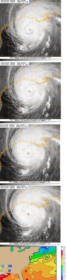
On September 23, 2005 just before 20z Reuters reported: "The latest satellite photos are showing Rita falling apart rapidly. The eye is almost non-discernable. The whole hurricane structure looks ragged," said Charlie Notis at Freese-Notis Weather, a private weather forecasting firm based in Iowa.

Such a comment was meteorologically incorrect. It was also potentially reckless. Let's take a closer look.

At the time Rita was supposedly "falling apart rapidly," it was merely undergoing an eye wall reorganization that is fairly commonplace in major hurricanes. The reality of such reorganizations is actually quite basic knowledge. Nonetheless, it was not deteriorating substantially.

∙ Current intensity rating at 9/23 18z: 6.0/6.5: Translation: some weakening was occuring but Rita was a very strong hurricane and not "falling apart rapidly."

∙ If one examines the satellite pictures--that were described as the basis of the conclusion--between 18:15z and 19:45z at 30-minute intervals, one finds a near steady state/weak erosion situation. In fact, the eye seemed to be growing better toward the end:

Image

Of course, if it were I who was making a diagnosis, I'd also look at other data, too. Relying on a single piece of data creates an unnecessary risk of error. In my view, it is good practice to look for support from multiple pieces of data.

∙ Pressure or the hurricane's proverbial "pulse:" fluctuating but relatively constant:

9/23 11 am: 929 mb
9/23 2 pm: 931 mb
9/23 5 pm: 930 mb

∙ Wind speed had dropped but not sharply:

9/23 11 am: 135 mph
9/23 2 pm: 125 mph
9/23 5 pm: 125 mph

CI estimate of 6.0 suggested a higher wind speed than 125 mph at 2 pm, so I would have been cautious about assuming that the winds were rapidly falling off.

I'd also look at the environment ahead:

∙ Modest shear: generally 10 kts - 15 kts. Not great for intensification but not a killer.

∙ SSTs: An important patch of 30°C-31°C water lay just in front of Rita. Hurricane Heat Content per the NRL site was 50.000 for that patch of water.

That suggested that any weakening would likely level off. Hence, even if one went with a 5 mph - 10 mph reduction at landfall, that would still imply a major hurricane landfall.

The bottom line is this:

1) The methodology behind the hypothesis--stated as a conclusion to the international media--that Rita was "falling apart rapidly" was not, at least in my view, very sound. It did not take into consideration some of the more basic parameters one would or should look at in estimating the evolution of a hurricane's intensity at a given point in time. Yes, intensity forecasting is difficult. But in this case, I'm not commenting on an intensity forecast. I'm commenting on an observation that very clearly was not consistent with the satellite imagery nor the actual data being reported by satellites, the NHC, etc.

2) Such a message could have had the unintended effect of encouraging complacency with a dangerous hurricane. It could also have created confusion as it contradicted the NHC.

3) If this message was intended to serve as a news "scoop," that's a very bad way to go about garnering publicity. Needless to say, now one can look back and rightly ask, "I thought it was 'falling apart rapidly.' If so, why did a major hurricane make landfall?"

4) In cases where dangerous storms threaten, and this is my main point, people should be particularly cautious that any facts that are set forth as facts--stating that Rita is "falling apart rapidly" as opposed to the more conditional "I believe Rita is falling apart rapidly" or "I expect that Rita will fall apart rapidly"--are reliable. Check to see if a fluctuation is, in fact, a trend. Not every wobble is indicative of a track change. Not every fluctuation in the central pressure, wind speed, condition of a storm's eye is indicative that the changes are of a permanent nature. With Rita still more than 12 hours from landfall, it would not have been unreasonable to wait for the 5 pm data before reaching such conclusions.

In this case, as I noted above in my dissection of the situation, I do not believe a reasonable person could suggest that statement of fact was reliable. Of course, later data demonstrated that it was not.

The National Hurricane Center reported that Rita came ashore as a Category 3 hurricane. Excerpts from its 4 am CDT advisory:

ZCZC MIATCPAT3 ALL
TTAA00 KNHC DDHHMM
BULLETIN
HURRICANE RITA ADVISORY NUMBER 27
NWS TPC/NATIONAL HURRICANE CENTER MIAMI FL
4 AM CDT SAT SEP 24 2005

...RITA MOVES ONSHORE NEAR SABINE PASS AS A DANGEROUS CATEGORY THREE HURRICANE...CURRENTLY NEAR PORT ARTHUR TEXAS...

AT 4 AM CDT...0900Z...THE CENTER OF HURRICANE RITA WAS LOCATED NEAR LATITUDE 29.9 NORTH...LONGITUDE 93.9 WEST OR NEAR PORT ARTHUR TEXAS.

RITA IS MOVING TOWARD THE NORTHWEST NEAR 12 MPH. A GRADUAL TURN TOWARD THE NORTH AND A DECREASE IN FORWARD MOTION IS EXPECTED DURING THE NEXT 24 HOURS. THIS MOTION SHOULD BRING THE CENTER OF RITA FARTHER INLAND OVER SOUTHEASTERN TEXAS TODAY.

REPORTS FROM AIR FORCE RESERVE HURRICANE HUNTER AIRCRAFT AND NATIONAL WEATHER SERVICE DOPPLER RADARS INDICATE THAT MAXIMUM SUSTAINED WINDS ARE NEAR 120 MPH...WITH HIGHER GUSTS. THIS MAKES RITA A CATEGORY THREE HURRICANE ON THE SAFFIR-SIMPSON SCALE. RITA SHOULD WEAKEN TODAY AS THE CENTER MOVES FARTHER INLAND.


Later, though, the individual responsible attempted to "spin" the assessment possibly to make it appear that his misdiagnosis was, in fact, reliable. He termed Rita perhaps "one of the biggest duds of all time."

Again, Reuters reported: "From what once was a super hurricane, this could turn into one of the biggest duds of all time," said Charles Notis at Freese-Notis Weather, a private weather forecasting firm.

I'm sorry to say it, but with all due respect, based on the two Reuters stories, I believe this individual knows little or nothing about hurricanes. Furthermore, his post-landfall comments demonstrate that he has no perspective into the damage past hurricanes have caused and out of this lack of perspective appears to subscribe to the idea that if a mega-disaster along the lines of Katrina has not occurred, then the event is a "dud."

Nothing could be farther from the truth. A multibillion dollar figure for damage, which appears highly likely for Rita, is not "one of the biggest duds of all time." A landfalling Category 3 hurricane--just the 93rd to have made landfall since 1851 and 95th to have brought major hurricane conditions to the U.S. since that time--is not an everyday event, even if 2004 and 2005 have seen 3 such hurricanes make U.S. landfall. A hurricane that comes ashore with 120 mph maximum sustained winds does not deliver merely a lazy light breeze to those in its eye wall. By no reasonable criteria is a landfalling Category 3 hurricane that brought with it a 10-15-foot storm surge "one of the biggest duds of all time."

Katrina was a Category 1 Hurricane at Landfall:

Even before a wide range of data was available and the preliminary H-Wind Analysis (with its inherent limitations) did not support a landfalling Category 1 hurricane, the October 4, 2005 issue of the South Florida Sun-Sentinel reported:

Robert Howard, an assistant professor of atmospheric sciences at the University of Louisiana at Monroe, said Katrina might have been a Category 1 at landfall.

In the same area were the hurricane center found 145 mph winds, he said a 2-meter tower near Buras showed gusts of 114 mph and sustained winds of about 94 mph, or strong Category 1 status.


First, Mr. Howard should know that a single data point is meaningless from a statistical perspective. That's very basic statistics.

Second, he should be aware that wind equipment can be destroyed as winds reach very high levels. The NWS New Orleans noted on October 3:

Code: Select all

EMERGENCY OPERATIONS CENTERS...PEAK GUST OBSERVED BEFORE  WIND EQUIPMENT WAS BLOWN DOWN.    PASCAGOULA -JACKSON COUNTY MS EOC -                       PEAK       108 KT    POPLARVILLE - PEARL RIVER COUNTY MS EOC                       PEAK       117 KT


Third, one should refrain from making premature judgments before a comprehensive set of information is available.

Unfortunately, Mr. Howard showed no such discipline and made his sensationalist claim that Katrina was a Category 1 hurricane at landfall even as the early data strongly suggested otherwise.

What to do?

Bad information, sensationalist claims, and reckless inaccurate observations of how a tropical cyclone is evolving do not serve the public interest. While the temptation to see one's name in print might be high and sensationalist claims might open the door to such opportunities, I very strongly believe that those who apparently lack basic knowledge or willingness to bring rigor to assessments of tropical cyclones should refrain from making unfounded, inaccurate, and misleading statements. Such statements are not constructive. Instead, they can be destructive.

Those who have understanding/knowledge of tropical cyclones should actively debunk sensationalist, unfounded, or badly flawed assessments. Leaving them unchallenged can only create an unintended perception of authority or accuracy. Such perceptions can, eventually, have adverse public consequences.

Furthermore, it might be good practice for the Media to rely more heavily on the NHC or NWS accounts in determining whether or not a piece of information is reliable. Post-storm assessments can wait for the NHC's preliminary report.

Clearly, this was a very blunt--perhaps not popular--assessment. However, I am very concerned about this issue and its long-term consequences if it is not noted and addressed. Certainly, given my historical knowledge of major hurricanes, I believe it would have been irresponsible on my part to avoid commenting on two very clear examples of bad, unsupported information that passed muster with the Media.
0 likes   

User avatar
skysummit
S2K Supporter
S2K Supporter
Posts: 5305
Age: 49
Joined: Tue Aug 31, 2004 11:09 pm
Location: Ponchatoula, LA
Contact:

#2 Postby skysummit » Thu Oct 06, 2005 10:58 am

OUTSTANDING post Don. It's people like that who really need to get taken away from the public's eyes and ears before many more get killed.
0 likes   

User avatar
dhweather
S2K Supporter
S2K Supporter
Posts: 6199
Joined: Sat Aug 14, 2004 9:29 pm
Location: Heath, TX
Contact:

#3 Postby dhweather » Thu Oct 06, 2005 10:59 am

Don, as always, an exceptional and sound commentary and analysis.

The problem with the media is that desire to get the "scoop" and to
stir up controversy. This has become a major problem, IMHO, since
some news shows now appear to be similar to the Jerry Springer show.

David
0 likes   

User avatar
terstorm1012
S2K Supporter
S2K Supporter
Posts: 1314
Age: 44
Joined: Fri Sep 10, 2004 5:36 pm
Location: Millersburg, PA

#4 Postby terstorm1012 » Thu Oct 06, 2005 11:42 am

Excellent post. 2 thumbs and 2 big toes up!

Sometimes I read this inaccurate info and scream!
0 likes   

User avatar
Tampa Bay Hurricane
Category 5
Category 5
Posts: 5598
Age: 37
Joined: Fri Jul 22, 2005 7:54 pm
Location: St. Petersburg, FL

#5 Postby Tampa Bay Hurricane » Thu Oct 06, 2005 11:44 am

Thank you Don. You have made excellent points concerning
issues in the media that I have been concerned about. :wink:
0 likes   

User avatar
DESTRUCTION5
Category 5
Category 5
Posts: 4430
Age: 44
Joined: Wed Sep 03, 2003 11:25 am
Location: Stuart, FL

#6 Postby DESTRUCTION5 » Thu Oct 06, 2005 11:47 am

Now this is some Quality Litature...
0 likes   

User avatar
Cat5survivor
Tropical Low
Tropical Low
Posts: 45
Joined: Thu Sep 02, 2004 12:49 pm
Location: Patrick AFB, Fl

Thank You Don

#7 Postby Cat5survivor » Thu Oct 06, 2005 12:10 pm

Even with a hurricane like Andrew it took the weather channel 10 YEARS to admit that it was a category 5. There are ONLY TWO internet sites to trust when a hurricane is knocking on your door...First is http://www.weather.gov and second (but never last) is http://www.storm2k.org. There is no hype and the facts are there. Thanks to Don and MWatson and Derek and the others for always keeping things in perspective for the rest of the uneducated (I'm speaking of myself of course). :D
0 likes   

User avatar
artist
Category 5
Category 5
Posts: 9792
Joined: Mon Jun 06, 2005 3:26 pm
Location: West Palm

#8 Postby artist » Thu Oct 06, 2005 12:26 pm

also makes the point that allowing us to get our weather from pirvate co.'s versus the NWS or the NHC could be extremely dangerous as well!

Say ~NO~ to the bill!
0 likes   

Valkhorn
Category 1
Category 1
Posts: 492
Joined: Wed Sep 10, 2003 4:09 am
Contact:

#9 Postby Valkhorn » Thu Oct 06, 2005 12:35 pm

There's also the guy on CNN who kept claiming during Katrina that the winds on the eastern side of a storm should be tacked onto the forward speed and subtracted on the western side.

That is really a myth.
0 likes   

User avatar
terstorm1012
S2K Supporter
S2K Supporter
Posts: 1314
Age: 44
Joined: Fri Sep 10, 2004 5:36 pm
Location: Millersburg, PA

#10 Postby terstorm1012 » Thu Oct 06, 2005 4:13 pm

bump. very important topic i think.
0 likes   

User avatar
LAwxrgal
S2K Supporter
S2K Supporter
Posts: 1763
Joined: Tue Jul 06, 2004 1:05 pm
Location: Reserve, LA (30 mi west of NOLA)

#11 Postby LAwxrgal » Thu Oct 06, 2005 5:28 pm

Don, I agree with you 2000%. It is stuff like this during the national newscasts that really get my blood boiling. And let's not get into the sensationalization they did for ratings.
0 likes   
Andrew 92/Isidore & Lili 02/Bill 03/Katrina & Rita 05/Gustav & Ike 08/Isaac 12 (flooded my house)/Harvey 17/Barry 19/Cristobal 20/Claudette 21/Ida 21 (In the Eye)/Francine 24
Wake me up when November ends

User avatar
caribepr
Category 5
Category 5
Posts: 1794
Joined: Fri Sep 05, 2003 10:43 pm
Location: Culebra, PR 18.33 65.33

#12 Postby caribepr » Thu Oct 06, 2005 5:30 pm

As ever, Don, points made, solutions offered, well written, easily understood. Hmm, one might think you have had some practice at this! 8-)
0 likes   

User avatar
bvigal
S2K Supporter
S2K Supporter
Posts: 2276
Joined: Sun Jul 24, 2005 8:49 am
Location: British Virgin Islands
Contact:

#13 Postby bvigal » Thu Oct 06, 2005 6:15 pm

This is an EXCELLENT post, Don, and thanks for putting it together!!!

I myself wrote to Reuters, after finding the most amazing thing on one of their websites. Here's their response, with my letter attached:


Tuesday, September 13, 2005 8:55 AM
Thanks for your email. This is content that is provided by one of our partners and we agree that it must be as accurate as possible. Thus we are talking to them about what may have led to this error and how we can ensure the accuracy of information in future.
Best regards,
Megan


Megan Rowling
Reuters AlertNet
Reuters Foundation
Email: megan.rowling@reuters.com
Tel: +44 (0)20 7542 3405
Fax: +44 (0)20 7278 9345
http://www.alertnet.org for news and information on emergency relief

-----Original Message-----
Sent: 11 September 2005 13:21
To: AlertNet
Subject: Hurricane Ophelia

on your site at 12z 11th September: from page
http://www.alertnet.org/thefacts/relief ... N_AL16.htm

************
Hurricane Ophelia
11 Sep 2005 08:52:00 GMT

Source: Tropical Storm Risk
Mark Saunders


"Hurricane Ophelia struck the United States at about 03:00 GMT on 11 September. Data supplied by the US National Hurricane Center suggest that the point of landfall was near 31.8 N, 75.8 W. Ophelia brought 1-minute maximum sustained winds to the region of around 129 km/hr (80 mph). Wind gusts in the area may have been considerably higher. "

*************

What on earth are you talking about? This storm hasn't hit the U.S.! And there can be no "data supplied by the NHC" suggesting a point of landfall. I checked out tropicalstormrisk.com, and can find no indication of a landfall.

This seems indicative of the problems with news media, too much hurry to publish, too sensational, and not checking the facts. This is irresponsible, in my opinion. It makes me question the validity of everything on your site.


Can you believe they would post a landfall before it happened??? I think they need a big slap on the pocketbook!! :lol:
0 likes   

User avatar
dvdweatherwizard
Tropical Storm
Tropical Storm
Posts: 114
Age: 43
Joined: Sun Sep 12, 2004 7:23 pm
Location: Melbourne, FL
Contact:

#14 Postby dvdweatherwizard » Thu Oct 06, 2005 7:09 pm

Wow, this is fabulous and eye opening information. Thanks for gathering this up and composing it so well. The assistant professor from UL-Monroe holds a Ph.D. according to their website. What a joke. I can't decide if that is more disturbing or the Freese-Notis story is more disturbing. I can't believe somebody with a Ph.D. said something like that, or maybe I can.

In his defense though, perhaps the media spun or interpreted what he said to seem more dramatic. It is easy to quote somebody out of context, and it will seem like they said something totally different than what they really said. I hope that is what happened for higher education's sake in this country.
0 likes   

greg_kfdm_tv
Professional-Met
Professional-Met
Posts: 110
Joined: Fri Aug 29, 2003 8:50 pm
Location: Beaumont, Texas
Contact:

#15 Postby greg_kfdm_tv » Thu Oct 06, 2005 8:21 pm

Don, great post.

I just returned from a ground survey of Holly Beach, Louisiana in Cameron Parish. This town was ground zero for the eastern eyewall of Rita.

Surge height was 15-20 feet with total devastation of around 400 beach homes. It has the look of an atomic blast...even the pilings the buildings set upon were ripped from the sand. It was impossible to tell that individual buildings once stood there. Furthermore, the edge of the surge line was located north of the intracoastal waterway along Highway 27 just southwest of Lake Charles...some 20 miles inland.

Even though the winds had decreased with Rita, much like Katrina, the surge was most impressive...certainly of category 4 intensity.

Fortunately, no lives were lost in Holly Beach because no one was there. They listened to the warnings and evacuated. Also, many recalled the death toll in Audrey in 1957 when hundreds were killed in the same exact area.
0 likes   

User avatar
Ixolib
Category 5
Category 5
Posts: 2741
Age: 68
Joined: Sun Aug 08, 2004 8:55 pm
Location: Biloxi, MS

#16 Postby Ixolib » Fri Oct 07, 2005 12:21 am

artist wrote:also makes the point that allowing us to get our weather from pirvate co.'s versus the NWS or the NHC could be extremely dangerous as well!

Say ~NO~ to the bill!


I don't understand the whole "private weather" thing anyway. I mean, why pay somebody when it's already available free? And they're all basing, at least in large percentage, their "forecasts" on what they've gotten from the government sources anyway - although they sometimes have "access" to the info somewhat sooner than the rest of us.
0 likes   

User avatar
weatherSnoop
S2K Supporter
S2K Supporter
Posts: 702
Age: 63
Joined: Wed Oct 09, 2002 10:06 pm
Location: Tampa, FL
Contact:

#17 Postby weatherSnoop » Fri Oct 07, 2005 12:57 am

Ixolib...I agree with you on that. When the private sector "goes out on their own", they tend to provide information that (IMHO) misleads the public. They are not as specific as the TPC and NHC, therefore they do not have to alter their forcast "aka fligh by the seat of their pants" like the professionals at the "government supported" agencies. No one wants to be wrong in their forcast, but I believe that some may not feel the need to be quite as right! (if that makes sense).
0 likes   

donsutherland1
S2K Analyst
S2K Analyst
Posts: 2718
Joined: Mon Sep 15, 2003 8:49 pm
Location: New York

Re: The Dissemination of Bad Information on Tropical Cyclon

#18 Postby donsutherland1 » Fri Oct 07, 2005 10:38 am

One additional point that I had not made.

At the beginning of this thread, I noted, the October 4, 2005 issue of the South Florida Sun-Sentinel reported:

Robert Howard, an assistant professor of atmospheric sciences at the University of Louisiana at Monroe, said Katrina might have been a Category 1 at landfall.

In the same area were the hurricane center found 145 mph winds, he said a 2-meter tower near Buras showed gusts of 114 mph and sustained winds of about 94 mph, or strong Category 1 status.


If one reads through the literature on wind assessments, one should also note that reliance on raw data can lead to inaccurate conclusions. Data needs to be adjusted for such factors as the instrument's exposure, the period for which the wind was averaged, the time at which the wind occurred relative to the storm's position, the height of the instrument, etc.

From the news article, it appears that truly basic errors were made not only in the reliance on a single instrument but also in the application of raw data in reaching the "remarkable" conclusion that Katrina was a Category 1 hurricane at landfall. Even the initial H-Wind Analysis does not support such a wild conclusion.

Based on the news account, I cannot overemphasize just how flawed the speculative estimate is. It is tantamount to taking an untested hypothesis and advancing it as a conclusion. That's speculation. It is not remotely consistent with the scientific method. In my view, it would not pass any reasonably rigorous peer review process.

I strongly believe that one should wait for the NHC's preliminary report for more credible estimates. In the meantime, the Category 1 speculation--highly unsound both statistically and scientifically--is almost certainly not credible. It should never have been published.
0 likes   

donsutherland1
S2K Analyst
S2K Analyst
Posts: 2718
Joined: Mon Sep 15, 2003 8:49 pm
Location: New York

#19 Postby donsutherland1 » Fri Oct 07, 2005 10:42 am

Very interesting find, Bvigal!

It should be noted that Reuters Alertnet, which says that its information on Ophelia's "landfall" came from one of its sources, had publicized Mr. Notis' incorrect assessment that Rita was "falling apart rapidly." Perhaps Reuters needs to assess its quality control process before posting such accounts. In general, if there's doubt, Reuters should stick with NHC info.
0 likes   

jax

#20 Postby jax » Fri Oct 07, 2005 10:57 am

I think they call the the "Jessier Jackson" factor..
0 likes   


Return to “Talkin' Tropics”

Who is online

Users browsing this forum: Google [Bot], kevin, Team Ghost, Teban54 and 107 guests