It still holds a 3.0St
Still looks good appears to have a eye!
http://www.nrlmry.navy.mil/sat-bin/disp ... C_SCALE=15
Invest 96L Near Az Islands,Comments,Sat Pics,Models Thread
Moderator: S2k Moderators
Forum rules

The posts in this forum are NOT official forecasts and should not be used as such. They are just the opinion of the poster and may or may not be backed by sound meteorological data. They are NOT endorsed by any professional institution or STORM2K. For official information, please refer to products from the National Hurricane Center and National Weather Service.

296
WHXX01 KWBC 081903
CHGHUR
DISCLAIMER...NUMERICAL MODELS ARE SUBJECT TO LARGE ERRORS.
PLEASE REFER TO TPC/NHC OFFICIAL FORECASTS FOR TROPICAL CYCLONES.
.....THE FOLLOWING IS A TEST MESSAGE.....
NATIONAL HURRICANE CENTER NORTH ATLANTIC OBJECTIVE AIDS FOR
TROPICAL STORM INVEST (AL962005) ON 20051008 1800 UTC
...00 HRS... ...12 HRS... ...24 HRS... ...36 HRS...
051008 1800 051009 0600 051009 1800 051010 0600
LAT LON LAT LON LAT LON LAT LON
BAMD 33.1N 20.1W 33.4N 20.0W 34.2N 19.3W 35.5N 16.9W
BAMM 33.1N 20.1W 33.6N 19.7W 34.7N 18.8W 36.1N 16.7W
A98E 33.1N 20.1W 33.2N 19.1W 34.1N 17.4W 36.2N 15.6W
LBAR 33.1N 20.1W 33.8N 19.0W 35.4N 17.4W 37.5N 15.0W
SHIP 45KTS 48KTS 50KTS 51KTS
DSHP 45KTS 48KTS 50KTS 51KTS
...48 HRS... ...72 HRS... ...96 HRS... ..120 HRS...
051010 1800 051011 1800 051012 1800 051013 1800
LAT LON LAT LON LAT LON LAT LON
BAMD 37.9N 12.4W 44.3N 4.1W 51.6N .0W 58.8N 1.3E
BAMM 38.4N 13.4W 44.8N 5.6W 52.1N .3E 58.7N 4.2E
A98E 38.5N 11.4W 39.7N 4.0W 42.0N 2.6E 44.7N 11.0E
LBAR 39.2N 11.3W 40.5N 3.6W 39.7N .8E 40.4N 4.9E
SHIP 53KTS 55KTS 55KTS 52KTS
DSHP 53KTS 43KTS 32KTS 32KTS
...INITIAL CONDITIONS...
LATCUR = 33.1N LONCUR = 20.1W DIRCUR = 80DEG SPDCUR = 4KT
LATM12 = 32.9N LONM12 = 20.6W DIRM12 = 84DEG SPDM12 = 5KT
LATM24 = 33.4N LONM24 = 22.8W
WNDCUR = 45KT RMAXWD = 0NM WNDM12 = 40KT
CENPRS = 1000MB OUTPRS = 1008MB OUTRAD = 150NM SDEPTH = D
RD34NE = 60NM RD34SE = 60NM RD34SW = 60NM RD34NW = 60NM
.....THE ABOVE HAS BEEN A TEST MESSAGE.....
It says "Tropical Storm Invest" on the header. An upgrade at 5pm?
0 likes
-
Tampa Bay Hurricane

- Category 5

- Posts: 5598
- Age: 38
- Joined: Fri Jul 22, 2005 7:54 pm
- Location: St. Petersburg, FL
-
cycloneye

- Admin

- Posts: 148797
- Age: 69
- Joined: Thu Oct 10, 2002 10:54 am
- Location: San Juan, Puerto Rico
We will know very soon if we have a subtropical cyclone.
0 likes
Visit the Caribbean-Central America Weather Thread where you can find at first post web cams,radars
and observations from Caribbean basin members Click Here
and observations from Caribbean basin members Click Here


-
cycloneye
- Admin
- Posts: 148797
- Age: 69
- Joined: Thu Oct 10, 2002 10:54 am
- Location: San Juan, Puerto Rico
Dont expect an advisorie at 5 PM because now I saw the header of the models that says AL96 and not AL23 
Last edited by cycloneye on Sat Oct 08, 2005 3:48 pm, edited 1 time in total.
0 likes
Visit the Caribbean-Central America Weather Thread where you can find at first post web cams,radars
and observations from Caribbean basin members Click Here
and observations from Caribbean basin members Click Here
-
TheEuropean

- Professional-Met

- Posts: 1797
- Age: 60
- Joined: Tue Sep 20, 2005 3:17 pm
- Location: Voerde, Germany
- Contact:
-
cycloneye
- Admin
- Posts: 148797
- Age: 69
- Joined: Thu Oct 10, 2002 10:54 am
- Location: San Juan, Puerto Rico
Thunder44 wrote:cycloneye wrote:Dont expect an advisorie at 5 PM because now I saw the header of the models that says AL96 and not AL23
It wouldn't say "AL23" because it would probably go straight to sub-tropical storm status, since it already has winds estimated 45kts.
Then what would the header say apart from the words (Tropical Storm Invest)?
0 likes
Visit the Caribbean-Central America Weather Thread where you can find at first post web cams,radars
and observations from Caribbean basin members Click Here
and observations from Caribbean basin members Click Here
-
cycloneye
- Admin
- Posts: 148797
- Age: 69
- Joined: Thu Oct 10, 2002 10:54 am
- Location: San Juan, Puerto Rico
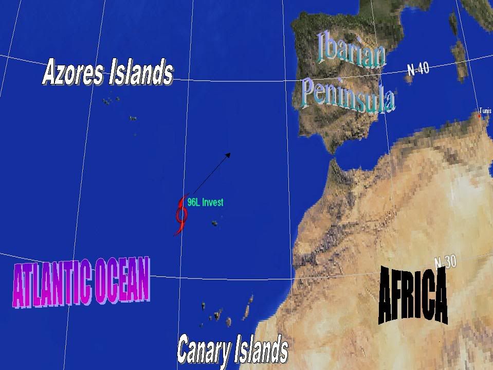
A NEARLY STATIONARY AND NON-TROPICAL LOW PRESSURE SYSTEM LOCATED
ABOUT MIDWAY BETWEEN THE AZORES AND THE CANARY ISLANDS HAS CHANGED
LITTLE THIS AFTERNOON. WHILE THIS SYSTEM IS OVER RELATIVELY COLD
SEA SURFACE TEMPERATURES... SHOWER ACTIVITY IS SOMEWHAT
CONCENTRATED NEAR THE CIRCULATION CENTER. THIS SYSTEM WILL BE
MONITORED FOR ANY ADDITIONAL SIGNS OF SUBTROPICAL CYCLONE
DEVELOPMENT BEFORE IT MOVES NORTHEASTWARD TOWARD EVEN COLDER WATERS
DURING THE NEXT DAY OR TWO.
5:30 PM TWO
0 likes
Visit the Caribbean-Central America Weather Thread where you can find at first post web cams,radars
and observations from Caribbean basin members Click Here
and observations from Caribbean basin members Click Here
-
P.K.

- Professional-Met
- Posts: 5149
- Joined: Thu Sep 23, 2004 5:57 pm
- Location: Watford, England
- Contact:
Certainly looks interesting on the sat images, see http://www.ukweatherworld.co.uk/forum/forums/thread-view.asp?tid=24287&posts=29
0 likes
-
Matt-hurricanewatcher
-
Coredesat
Who is online
Users browsing this forum: gib, Team Ghost and 72 guests