My thoughts on Wilma...

This is the general tropical discussion area. Anyone can take their shot at predicting a storms path.

Moderator: S2k Moderators

Forum rules

The posts in this forum are NOT official forecasts and should not be used as such. They are just the opinion of the poster and may or may not be backed by sound meteorological data. They are NOT endorsed by any professional institution or STORM2K. For official information, please refer to products from the National Hurricane Center and National Weather Service.

Help Support Storm2K
Message
Author
Anonymous

My thoughts on Wilma...

#1 Postby Anonymous » Mon Oct 17, 2005 10:59 pm

The following post is NOT an official forecast and should not be used as such. It is just the opinion of the poster and may or may not be backed by sound meteorological data. It is NOT endorsed by any professional institution including storm2k.org For Official Information please refer to the NHC and NWS products.

Here is my forecast for Wilma:::
Image

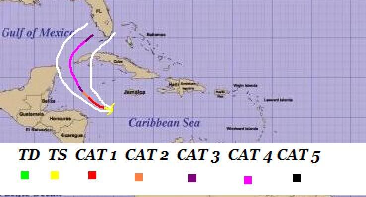
I think South Florida might not know just what they may be in for...with a fast moving, powerful hurricane. However, the surge potential in that are is SIGNIFICANT. So, if it peaks out at 115-125 kt, as I expect...even if it weakens, you have a significant surge coming. This one needs to be taken very seriously.
0 likes   

fasterdisaster
Category 5
Category 5
Posts: 1868
Joined: Mon Sep 19, 2005 4:41 pm
Location: Miami, Florida

#2 Postby fasterdisaster » Mon Oct 17, 2005 11:01 pm

Mike, should Miami scream their heads off?
0 likes   

Anonymous

#3 Postby Anonymous » Mon Oct 17, 2005 11:02 pm

fasterdisaster wrote:Mike, should Miami scream their heads off?


Not really. The idea of this making landfall as a Cat 3 is very possible...but exiting as a Cat 2...I see less likely.
0 likes   

Brent
S2K Supporter
S2K Supporter
Posts: 38264
Age: 37
Joined: Sun May 16, 2004 10:30 pm
Location: Tulsa Oklahoma
Contact:

#4 Postby Brent » Mon Oct 17, 2005 11:32 pm

Are you predicting a Cat 5? :eek:
0 likes   
#neversummer

SamSagnella
Category 2
Category 2
Posts: 630
Age: 39
Joined: Fri Aug 26, 2005 12:02 pm
Location: Westport, CT
Contact:

#5 Postby SamSagnella » Mon Oct 17, 2005 11:32 pm

Look at the color key...no, he isn't :wink:
0 likes   

User avatar
jasons2k
Storm2k Executive
Storm2k Executive
Posts: 8250
Age: 52
Joined: Wed Jul 06, 2005 12:32 pm
Location: The Woodlands, TX

#6 Postby jasons2k » Mon Oct 17, 2005 11:33 pm

Good call Mike, but I think it will come in further south, near Key West.
0 likes   

Brent
S2K Supporter
S2K Supporter
Posts: 38264
Age: 37
Joined: Sun May 16, 2004 10:30 pm
Location: Tulsa Oklahoma
Contact:

#7 Postby Brent » Mon Oct 17, 2005 11:34 pm

SamSagnella wrote:Look at the color key...no, he isn't :wink:


Oh I see now... LOL! I knew that color wasn't a 4...
0 likes   
#neversummer

User avatar
Fego
S2K Supporter
S2K Supporter
Posts: 767
Age: 65
Joined: Sun Apr 18, 2004 7:58 pm
Location: San Juan, Puerto Rico
Contact:

#8 Postby Fego » Tue Oct 18, 2005 1:12 am

Just a reminder. Do not concentrate in the eye track only, do not forget the TS wind, do not forget the rain and floods and do not forget the potential surge.
0 likes   
Go Giants! Go Niners! Go Warriors!

User avatar
artist
Category 5
Category 5
Posts: 9792
Joined: Mon Jun 06, 2005 3:26 pm
Location: West Palm

#9 Postby artist » Tue Oct 18, 2005 1:21 am

Fego- excellent post!
0 likes   

User avatar
mobilebay
Category 5
Category 5
Posts: 1853
Age: 51
Joined: Wed Aug 18, 2004 1:22 am
Location: Mobile, Alabama

#10 Postby mobilebay » Tue Oct 18, 2005 1:28 am

it is becoming pretty clear that this is going to be a South Florida event!
0 likes   

ericinmia
S2K Supporter
S2K Supporter
Posts: 1573
Joined: Fri Sep 12, 2003 11:15 pm
Location: Miami Lakes, FL

#11 Postby ericinmia » Tue Oct 18, 2005 1:33 am

Also if the GFS and UKMET and GFDL to name a couple have it their way (burger king) ;)

Then this will cross florida at 25+mph in under 6 hours from coast to coast.
Hence, it will loose very little in orginization due to frictional effects.
0 likes   

User avatar
mobilebay
Category 5
Category 5
Posts: 1853
Age: 51
Joined: Wed Aug 18, 2004 1:22 am
Location: Mobile, Alabama

#12 Postby mobilebay » Tue Oct 18, 2005 1:35 am

ericinmia wrote:Also if the GFS and UKMET and GFDL to name a couple have it their way (burger king) ;)

Then this will cross florida at 25+mph in under 6 hours from coast to coast.
Hence, it will loose very little in orginization due to frictional effects.

hey Eric, do you have your Weather station ready to go.
0 likes   

User avatar
artist
Category 5
Category 5
Posts: 9792
Joined: Mon Jun 06, 2005 3:26 pm
Location: West Palm

#13 Postby artist » Tue Oct 18, 2005 1:49 am

that could be good news in some ways though couldn't it? Seems the storms lately they have been most damaging have been fairly slow movers.
0 likes   

tornadochaser86
Tropical Storm
Tropical Storm
Posts: 197
Joined: Fri Sep 23, 2005 11:19 am
Location: University of South Alabama
Contact:

#14 Postby tornadochaser86 » Tue Oct 18, 2005 1:53 am

ya i dont really believe the turn will be that sharp they have it gooing almost at a 90 degree turn :roll:
0 likes   

User avatar
skysummit
S2K Supporter
S2K Supporter
Posts: 5305
Age: 49
Joined: Tue Aug 31, 2004 11:09 pm
Location: Ponchatoula, LA
Contact:

#15 Postby skysummit » Tue Oct 18, 2005 7:20 am

tornadochaser86 wrote:ya i dont really believe the turn will be that sharp they have it gooing almost at a 90 degree turn :roll:


That's probably because every model has it making that sharp turn. I was thinking yesterday that it would be more of a gradual turn just north of Tampa, but since every model is still staying consistant for the most part, I'll have to go with the sharper turn. The UKMET even has it missing Florida all together!
0 likes   

User avatar
johngaltfla
Category 5
Category 5
Posts: 2072
Joined: Sun Jul 10, 2005 9:17 pm
Location: Sarasota County, FL
Contact:

#16 Postby johngaltfla » Tue Oct 18, 2005 7:27 am

If Mike would be so kind as to move that northern part of his CONE OF DEATH down south about 100 miles, I'd feel a whole lot better about his forecast. :eek:
0 likes   

inotherwords
Category 2
Category 2
Posts: 773
Joined: Mon Aug 30, 2004 9:04 pm
Location: Nokomis, FL

#17 Postby inotherwords » Tue Oct 18, 2005 8:19 am

Kevin_Cho wrote:Jeeze Mike...if your predictions pan out, this will take Wilma directly over Naples, FL..my TOWN! lol...and I just moved to the city, which means i'm in a situation for almost certain mandantory evacuation if this comes around to our area.

Kevin Cho - Naples, FL
Jr: Naples High School


Kevin, do you know what evacuation zone you're in at your new home? Might be a good time to check.

I'm in a borderline 2/3 area and am only a half mile as the crow flies from the Gulf. I don't think the entire city of Naples would need to evacuate for a 3 or less, but it's just speculation on my part. (BTW, I'm up the coast between Sarasota and Venice, so I'm under the gun right now too ;-) )
0 likes   

User avatar
Trader Ron
S2K Supporter
S2K Supporter
Posts: 928
Joined: Tue Jul 22, 2003 7:25 pm
Location: Naples,Fl
Contact:

#18 Postby Trader Ron » Tue Oct 18, 2005 8:27 am

Kevin_Cho wrote:Jeeze Mike...if your predictions pan out, this will take Wilma directly over Naples, FL..my TOWN! lol...and I just moved to the city, which means i'm in a situation for almost certain mandantory evacuation if this comes around to our area.

Kevin Cho - Naples, FL
Jr: Naples High School


If I was evacuating, i would be leaving NO LATER than Thursday.
0 likes   


Return to “Talkin' Tropics”

Who is online

Users browsing this forum: Team Ghost and 236 guests