...what's the difference? I know that tropical systems are warm core but what happens to them when they turn "extratropical"?
Also, Nor'easters are considered "cold core" storms, correct? However, don't they get their energy from the ocean as well when they "bomb out" over the ocean?
Warm Core, Cold Core and Extratropical storms...
Moderator: S2k Moderators
Forum rules

The posts in this forum are NOT official forecasts and should not be used as such. They are just the opinion of the poster and may or may not be backed by sound meteorological data. They are NOT endorsed by any professional institution or STORM2K. For official information, please refer to products from the National Hurricane Center and National Weather Service.
-
senorpepr

- Military Met/Moderator

- Posts: 12542
- Age: 43
- Joined: Fri Aug 22, 2003 9:22 pm
- Location: Mackenbach, Germany
- Contact:
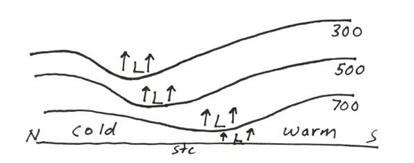
Okay... first I'll talk about cold-core lows. (This data is pretty much copied from http://www.theweatherprediction.com. He does a really good job describing it.)
Cold-core lows...
*Rising air in all levels of atmosphere
*Cover a relatively small synoptic scale area compared to high pressure systems. Their path can heavily influence precipitation totals
*Developed cold core lows tilt to the northwest with height
*Coldest temperatures are at center of low
*Air is cooled by adiabatic expansion and evaporational cooling of rain and/or snow
*Upper low can displace from lower level low, models have more difficulty handling upper level lows as compared to low level lows due to poorer model resolution in the upper levels
*Most mid-latitude cyclones are cold-core lows
*They cause widespread precipitation
*They are deep cored. Developed cold core lows will show at each mandatory level. They will have closed height contours in the low levels and shows as a synoptic scale trough in the upper levels
*Will develop into significant storm systems with a large release of latent heat
*Initially develop due to jet streaks, synoptic thermal gradient zones or vorticity spin-up
Here's a cross-profile of a cold-core low:
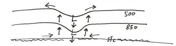
For a warm-core low such as a tropical cyclone... (warm-core lows like thermal lows that are found in the SW US are different)
*Deeper than thermal low, although they do weaken with height in upper levels
*Subsidence in center causes compressional warming
*Air rises rapidly around edges of eye (eye-wall)
*Develop over water
*Warm core low is strongest when vertically stacked. Significant wind shear will weaken warm core low. This is the opposite situation of a cold core low; strong cold core lows tilt with height.
Here's a cross-profile of a warm-core low:
As for an extratropical low...
Remember that a warm-core low has no temperature advection into it. In other words, no colder air is being pushed into the low. As for a cold-core low, there is temperature advection. Usually you'll find this advection in terms of a frontal boundary. Extratropical lows are former warm-core lows that have transitioned into a cold-core low. Basically, think of a remnant hurricane that now has fronts associated with it.
Now, you mentioned Nor'easters. They are cold-core because they have that temperature advection. The fact that they undergo cyclogenesis (deepening) over water doesn't take away from the fact that there is colder air being pushed into the low.
Hopefully this helps...
Cold-core lows...
*Rising air in all levels of atmosphere
*Cover a relatively small synoptic scale area compared to high pressure systems. Their path can heavily influence precipitation totals
*Developed cold core lows tilt to the northwest with height
*Coldest temperatures are at center of low
*Air is cooled by adiabatic expansion and evaporational cooling of rain and/or snow
*Upper low can displace from lower level low, models have more difficulty handling upper level lows as compared to low level lows due to poorer model resolution in the upper levels
*Most mid-latitude cyclones are cold-core lows
*They cause widespread precipitation
*They are deep cored. Developed cold core lows will show at each mandatory level. They will have closed height contours in the low levels and shows as a synoptic scale trough in the upper levels
*Will develop into significant storm systems with a large release of latent heat
*Initially develop due to jet streaks, synoptic thermal gradient zones or vorticity spin-up
Here's a cross-profile of a cold-core low:
For a warm-core low such as a tropical cyclone... (warm-core lows like thermal lows that are found in the SW US are different)
*Deeper than thermal low, although they do weaken with height in upper levels
*Subsidence in center causes compressional warming
*Air rises rapidly around edges of eye (eye-wall)
*Develop over water
*Warm core low is strongest when vertically stacked. Significant wind shear will weaken warm core low. This is the opposite situation of a cold core low; strong cold core lows tilt with height.
Here's a cross-profile of a warm-core low:
As for an extratropical low...
Remember that a warm-core low has no temperature advection into it. In other words, no colder air is being pushed into the low. As for a cold-core low, there is temperature advection. Usually you'll find this advection in terms of a frontal boundary. Extratropical lows are former warm-core lows that have transitioned into a cold-core low. Basically, think of a remnant hurricane that now has fronts associated with it.
Now, you mentioned Nor'easters. They are cold-core because they have that temperature advection. The fact that they undergo cyclogenesis (deepening) over water doesn't take away from the fact that there is colder air being pushed into the low.
Hopefully this helps...
0 likes
-
wxmann_91

- Category 5

- Posts: 8013
- Age: 34
- Joined: Fri Jul 15, 2005 2:49 pm
- Location: Southern California
- Contact:
Noreasters and upper-level lows are considered cold-core storms. When a tropical system becomes extratropical it becomes cold-core. Noreasters are indeed extratropical storms.
Warm core storms derive their energy directly from warm ocean water. Cold core storms derive their energy from baroclinic sources, i.e., they derive their energy from the difference of temperature in air masses.
As for noreasters that "bomb", the Gulf Stream is the reason why. The difference in temperatures between the warm Gulf Stream and the cold air above it helps rapid cyclogenisis.
Perhaps a pro met can provide a more detailed explanation, or you can use habyhints: http://www.theweatherprediction.com/habyhints/188/
EDIT: Senorpepr's post provides a much more detailed explanation.
Warm core storms derive their energy directly from warm ocean water. Cold core storms derive their energy from baroclinic sources, i.e., they derive their energy from the difference of temperature in air masses.
As for noreasters that "bomb", the Gulf Stream is the reason why. The difference in temperatures between the warm Gulf Stream and the cold air above it helps rapid cyclogenisis.
Perhaps a pro met can provide a more detailed explanation, or you can use habyhints: http://www.theweatherprediction.com/habyhints/188/
EDIT:
0 likes
-
Tampa Bay Hurricane

- Category 5
- Posts: 5598
- Age: 38
- Joined: Fri Jul 22, 2005 7:54 pm
- Location: St. Petersburg, FL


I'd give a good answer, but I don't have time. It essentially arises from the fact that tropical cyclones are essentially giant heat engines that derive their power from latent heat release. Extratropical cyclones derive their power from baroclinic instability.
Latent heat release does feed back into the baroclinic system, however, is large reason why extratropical cyclones that move up the east coast (Nor'easters) can be particularly intense. Strong extratropical cyclones are enhanced by strong upper-level dynamics (strong differential positive vorticity advection leads to surface pressure falls, and transverse circulations in the right-entrance and left exit regions of jet streaks aloft yield strong upper-level divergence, vertical motion, and surface pressure falls). This kind of becomes a chicken-and-egg issue, since the surface presssure falls lead to an enhanced pressure gradient, which in turn can lead to enhanced thermal advection and height falls/rises aloft (rises if low-level warm air advection is stronger than mid-level WAA, which is often the case). The sea-breeze boundary often serves as a focus for strong WAA, and the moist maritime air (even in winter, the air over the water is often considerably more moist than continental air) condenses and leads to surface pressure falls. This in turn strengthens the upper-level flow and enhances the curvature, leading to stronger vorticity (and vorticity advection) and stronger vertical motions related to ageostrophic winds. And the cycle continues... With tropical/warm-core cyclones, you don't want any sort of strong flow aloft. The evaporated ocean water is water vapor, which condenses in deep moist convection and releases energy in the process. This leads to surface pressure falls, which increases surface convergence, which in turn leads to stronger convection, stronger surface pressure falls, etc, etc etc. Warm-core cyclones (such as hurricanes) have winds that decrease in height above the friction layer, which is very different (an opposite in most cases) of strong extratropical cyclones.
Latent heat release does feed back into the baroclinic system, however, is large reason why extratropical cyclones that move up the east coast (Nor'easters) can be particularly intense. Strong extratropical cyclones are enhanced by strong upper-level dynamics (strong differential positive vorticity advection leads to surface pressure falls, and transverse circulations in the right-entrance and left exit regions of jet streaks aloft yield strong upper-level divergence, vertical motion, and surface pressure falls). This kind of becomes a chicken-and-egg issue, since the surface presssure falls lead to an enhanced pressure gradient, which in turn can lead to enhanced thermal advection and height falls/rises aloft (rises if low-level warm air advection is stronger than mid-level WAA, which is often the case). The sea-breeze boundary often serves as a focus for strong WAA, and the moist maritime air (even in winter, the air over the water is often considerably more moist than continental air) condenses and leads to surface pressure falls. This in turn strengthens the upper-level flow and enhances the curvature, leading to stronger vorticity (and vorticity advection) and stronger vertical motions related to ageostrophic winds. And the cycle continues... With tropical/warm-core cyclones, you don't want any sort of strong flow aloft. The evaporated ocean water is water vapor, which condenses in deep moist convection and releases energy in the process. This leads to surface pressure falls, which increases surface convergence, which in turn leads to stronger convection, stronger surface pressure falls, etc, etc etc. Warm-core cyclones (such as hurricanes) have winds that decrease in height above the friction layer, which is very different (an opposite in most cases) of strong extratropical cyclones.
Last edited by WxGuy1 on Tue Oct 25, 2005 8:05 pm, edited 2 times in total.
0 likes


-
FloridaHawk82
- Tropical Depression

- Posts: 79
- Joined: Mon Aug 30, 2004 10:39 pm
- Location: Coralville, IA
Re: Warm Core, Cold Core and Extratropical storms...
Stephanie wrote:...what's the difference? I know that tropical systems are warm core but what happens to them when they turn "extratropical"?
Also, Nor'easters are considered "cold core" storms, correct? However, don't they get their energy from the ocean as well when they "bomb out" over the ocean?
Great Question... Great Answers... Thank You.
How powerful can a cold-core storm become? Pressure/Wind Speed?
What is the most powerful cold-core storm on record?
0 likes

-
wxmann_91
- Category 5
- Posts: 8013
- Age: 34
- Joined: Fri Jul 15, 2005 2:49 pm
- Location: Southern California
- Contact:
Re: Warm Core, Cold Core and Extratropical storms...
FloridaHawk82 wrote:Stephanie wrote:...what's the difference? I know that tropical systems are warm core but what happens to them when they turn "extratropical"?
Also, Nor'easters are considered "cold core" storms, correct? However, don't they get their energy from the ocean as well when they "bomb out" over the ocean?
Great Question... Great Answers... Thank You.
How powerful can a cold-core storm become? Pressure/Wind Speed?
What is the most powerful cold-core storm on record?
I would say around 950 mb. The Superstorm in 1993 was around 960.
0 likes
Re: Warm Core, Cold Core and Extratropical storms...
wxmann_91 wrote:FloridaHawk82 wrote:Stephanie wrote:...what's the difference? I know that tropical systems are warm core but what happens to them when they turn "extratropical"?
Also, Nor'easters are considered "cold core" storms, correct? However, don't they get their energy from the ocean as well when they "bomb out" over the ocean?
Great Question... Great Answers... Thank You.
How powerful can a cold-core storm become? Pressure/Wind Speed?
What is the most powerful cold-core storm on record?
I would say around 950 mb. The Superstorm in 1993 was around 960.
There was a storm last winter that was also about 960mb., but it was a little farther from the coast, so the effects to sensible weather were much less severe than the 93 Superstorm.
0 likes
-
senorpepr
- Military Met/Moderator
- Posts: 12542
- Age: 43
- Joined: Fri Aug 22, 2003 9:22 pm
- Location: Mackenbach, Germany
- Contact:
Stephanie wrote:A cold-core low then, needs a cold front to get the ball rolling so to speak due to the differences in temperature?
Well... technically it doesn't need a cold front. A trough or purely some light cold air advection can get the job done while a cold front seperates whole air masses, but it make it easier to understand... yes: a cold front (or cold push) needs to be around to get the ball rolling.
0 likes
-
Stephanie

- S2K Supporter

- Posts: 23843
- Age: 63
- Joined: Thu Feb 06, 2003 9:53 am
- Location: Glassboro, NJ
Re: Warm Core, Cold Core and Extratropical storms...
FloridaHawk82 wrote:Stephanie wrote:...what's the difference? I know that tropical systems are warm core but what happens to them when they turn "extratropical"?
Also, Nor'easters are considered "cold core" storms, correct? However, don't they get their energy from the ocean as well when they "bomb out" over the ocean?
Great Question... Great Answers... Thank You.
How powerful can a cold-core storm become? Pressure/Wind Speed?
What is the most powerful cold-core storm on record?
I figured that your question and my feeble answer were going to get lost. Ironically, I HAVE been wondering about the differences recently.
0 likes
-
senorpepr
- Military Met/Moderator
- Posts: 12542
- Age: 43
- Joined: Fri Aug 22, 2003 9:22 pm
- Location: Mackenbach, Germany
- Contact:
Re: Warm Core, Cold Core and Extratropical storms...
I don't know what the "record" is per se, but it's probably much lower than 950mb. While I was forecasting in Europe, I've dealt with several occluded lows (a low with not just a cold and warm front, but also an occlusion) that had sub-945mb readings.wxmann_91 wrote:FloridaHawk82 wrote:Stephanie wrote:...what's the difference? I know that tropical systems are warm core but what happens to them when they turn "extratropical"?
Also, Nor'easters are considered "cold core" storms, correct? However, don't they get their energy from the ocean as well when they "bomb out" over the ocean?
Great Question... Great Answers... Thank You.
How powerful can a cold-core storm become? Pressure/Wind Speed?
What is the most powerful cold-core storm on record?
I would say around 950 mb. The Superstorm in 1993 was around 960.
0 likes
senorpepr wrote:Stephanie wrote:A cold-core low then, needs a cold front to get the ball rolling so to speak due to the differences in temperature?
Well... technically it doesn't need a cold front. A trough or purely some light cold air advection can get the job done while a cold front seperates whole air masses, but it make it easier to understand... yes: a cold front (or cold push) needs to be around to get the ball rolling.
A good stationary boundary will be similar, which is essentially the basis for the wave cyclone model.
0 likes
-
senorpepr
- Military Met/Moderator
- Posts: 12542
- Age: 43
- Joined: Fri Aug 22, 2003 9:22 pm
- Location: Mackenbach, Germany
- Contact:
Yes... very good point.WxGuy1 wrote:senorpepr wrote:Stephanie wrote:A cold-core low then, needs a cold front to get the ball rolling so to speak due to the differences in temperature?
Well... technically it doesn't need a cold front. A trough or purely some light cold air advection can get the job done while a cold front seperates whole air masses, but it make it easier to understand... yes: a cold front (or cold push) needs to be around to get the ball rolling.
A good stationary boundary will be similar, which is essentially the basis for the wave cyclone model.
0 likes
-
Stephanie
- S2K Supporter
- Posts: 23843
- Age: 63
- Joined: Thu Feb 06, 2003 9:53 am
- Location: Glassboro, NJ
senorpepr wrote:Stephanie wrote:A cold-core low then, needs a cold front to get the ball rolling so to speak due to the differences in temperature?
Well... technically it doesn't need a cold front. A trough or purely some light cold air advection can get the job done while a cold front seperates whole air masses, but it make it easier to understand... yes: a cold front (or cold push) needs to be around to get the ball rolling.
Yep, that's what I needed! LOL!
I tend to use cold front/trough interchangably.
0 likes
-
FloridaHawk82
- Tropical Depression
- Posts: 79
- Joined: Mon Aug 30, 2004 10:39 pm
- Location: Coralville, IA
Thanks. Now for another question from this uninformed....
In the past, I've read mention of "500 mb cold core low tornadoes". How does this relate?
FYI: The following link describing hurricane dynamics is one that I have found pretty good for the non-mets like myself...
http://www.newmediastudio.org/DataDiscovery/Hurr_ED_Center/Hurr_Structure_Energetics/Hurr_Struct.html
0 likes
-
wxmann_91
- Category 5
- Posts: 8013
- Age: 34
- Joined: Fri Jul 15, 2005 2:49 pm
- Location: Southern California
- Contact:
FloridaHawk82 wrote:Thanks. Now for another question from this uninformed....
In the past, I've read mention of "500 mb cold core low tornadoes". How does this relate?
FYI: The following link describing hurricane dynamics is one that I have found pretty good for the non-mets like myself...
http://www.newmediastudio.org/DataDiscovery/Hurr_ED_Center/Hurr_Structure_Energetics/Hurr_Struct.html
http://members.cox.net/jondavies4/041005nwks/041005nwks.htm
It may get a little technical BTW. Feel free to ask questions if you have trouble understanding.
0 likes
Who is online
Users browsing this forum: No registered users and 126 guests