TD 27,Comments,Sat Pics,Models Thread
Moderator: S2k Moderators
- SouthFloridawx
- S2K Supporter

- Posts: 8346
- Age: 47
- Joined: Tue Jul 26, 2005 1:16 am
- Location: Sarasota, FL
- Contact:
- DESTRUCTION5
- Category 5

- Posts: 4430
- Age: 44
- Joined: Wed Sep 03, 2003 11:25 am
- Location: Stuart, FL
- SouthFloridawx
- S2K Supporter

- Posts: 8346
- Age: 47
- Joined: Tue Jul 26, 2005 1:16 am
- Location: Sarasota, FL
- Contact:
DESTRUCTION5 wrote:southfloridawx2005 wrote:We will have to see what happens tonight. This system seems to do well at night....
LMAO...Its Nocturnal..
I think it will survive..looks like the LLC is reforming under the cold cloud tops...And become at least a CAT 2 by weeks end...
What is Dinural?
0 likes
- HURAKAN
- Professional-Met

- Posts: 46084
- Age: 39
- Joined: Thu May 20, 2004 4:34 pm
- Location: Key West, FL
- Contact:
southfloridawx2005 wrote:DESTRUCTION5 wrote:southfloridawx2005 wrote:We will have to see what happens tonight. This system seems to do well at night....
LMAO...Its Nocturnal..
I think it will survive..looks like the LLC is reforming under the cold cloud tops...And become at least a CAT 2 by weeks end...
What is Dinural?
"DIURNAL" MEANS DAY, [14th century. < late Latin diurnalis < Latin diurnus "daily" < dies "day"]
"NORTURNAL" MEANS NIGHT, [14th century. Directly or via French nocturne < ecclesiastical Latin nocturnus < Latin, "of the night" < noct- "night"]
Last edited by HURAKAN on Mon Nov 14, 2005 4:55 pm, edited 1 time in total.
0 likes
- Windtalker1
- S2K Supporter

- Posts: 523
- Age: 37
- Joined: Sun Jul 31, 2005 11:00 am
- Location: Mesa, Arizona
Even if it doesn't, look at all the convection in front of future Gamma. She will have no problems becoming a Cat 2 or 3 Hurricane http://www.ssd.noaa.gov/PS/TROP/DATA/RT ... -loop.htmlkrysof wrote:could we see a new center form closer to the convection
0 likes
- SouthFloridawx
- S2K Supporter

- Posts: 8346
- Age: 47
- Joined: Tue Jul 26, 2005 1:16 am
- Location: Sarasota, FL
- Contact:
HURAKAN wrote:southfloridawx2005 wrote:DESTRUCTION5 wrote:southfloridawx2005 wrote:We will have to see what happens tonight. This system seems to do well at night....
LMAO...Its Nocturnal..
I think it will survive..looks like the LLC is reforming under the cold cloud tops...And become at least a CAT 2 by weeks end...
What is Dinural?
"DIURNAL" MEANS DAY, [14th century. < late Latin diurnalis < Latin diurnus "daily" < dies "day"]
"NORTURNAL" MEANS NIGHT, [14th century. Directly or via French nocturne < ecclesiastical Latin nocturnus < Latin, "of the night" < noct- "night"]
thanks
0 likes
-
Weatherfreak000
remember
Wilma was never supposed to break Cat 2 and what happened there?
The water isn't quite as hot as back then yet, a Cat 1 hurricane is projected to form and we can always expect a cat above the official forecast.
Don't be suprised if we squeeze out one more major this year is my thoughts.
The water isn't quite as hot as back then yet, a Cat 1 hurricane is projected to form and we can always expect a cat above the official forecast.
Don't be suprised if we squeeze out one more major this year is my thoughts.
0 likes
- brunota2003
- S2K Supporter

- Posts: 9476
- Age: 35
- Joined: Sat Jul 30, 2005 9:56 pm
- Location: Stanton, KY...formerly Havelock, NC
- Contact:
- dixiebreeze
- S2K Supporter

- Posts: 5140
- Joined: Wed Sep 03, 2003 5:07 pm
- Location: crystal river, fla.
- WindRunner
- Category 5

- Posts: 5803
- Age: 35
- Joined: Fri Jul 29, 2005 8:07 pm
- Location: Warrenton, VA, but Albany, NY for school
- Contact:
- JamesFromMaine2
- Category 4

- Posts: 989
- Joined: Tue Jul 19, 2005 1:38 am
- Location: Portland Maine USA
- Contact:
- WindRunner
- Category 5

- Posts: 5803
- Age: 35
- Joined: Fri Jul 29, 2005 8:07 pm
- Location: Warrenton, VA, but Albany, NY for school
- Contact:
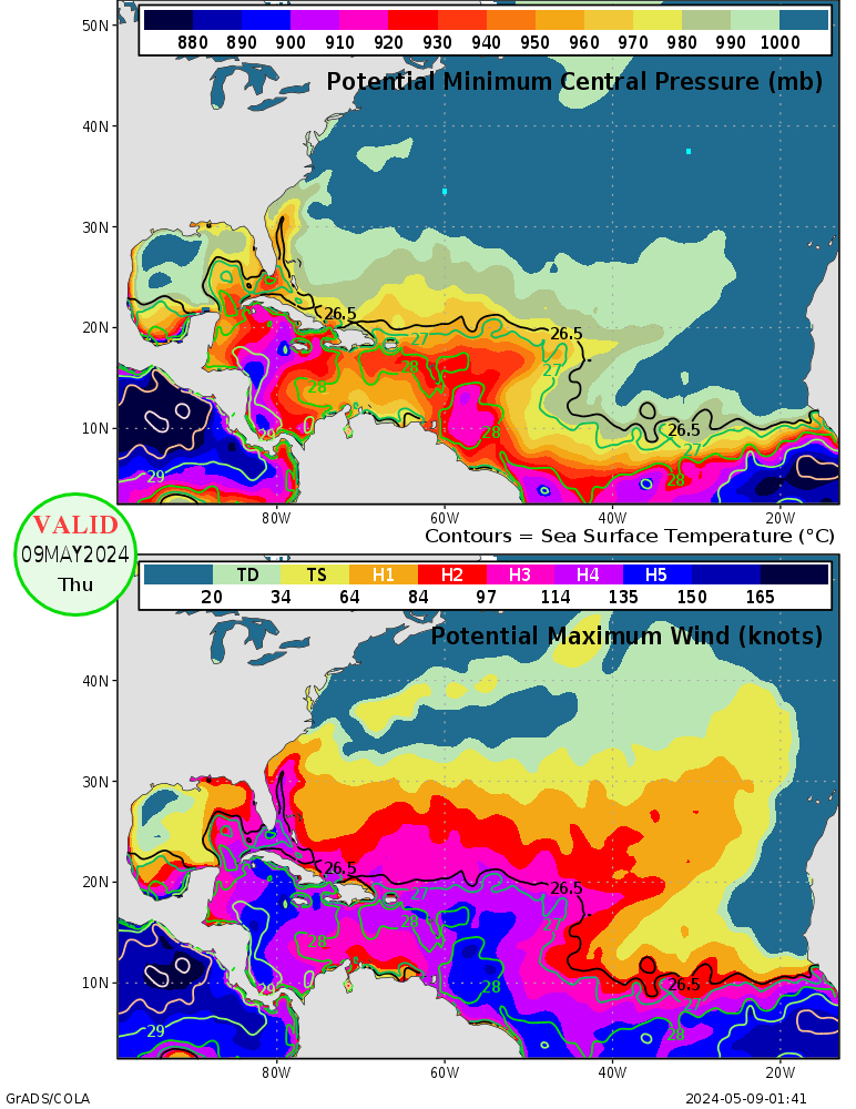
And the actual site: http://wxmaps.org/pix/hurpot.html
There's also ones for every other basin on there.
There's also ones for every other basin on there.
0 likes
- brunota2003
- S2K Supporter

- Posts: 9476
- Age: 35
- Joined: Sat Jul 30, 2005 9:56 pm
- Location: Stanton, KY...formerly Havelock, NC
- Contact:
- SouthFloridawx
- S2K Supporter

- Posts: 8346
- Age: 47
- Joined: Tue Jul 26, 2005 1:16 am
- Location: Sarasota, FL
- Contact:
- brunota2003
- S2K Supporter

- Posts: 9476
- Age: 35
- Joined: Sat Jul 30, 2005 9:56 pm
- Location: Stanton, KY...formerly Havelock, NC
- Contact:
http://wxmaps.org/pix/atlpot.pngsouthfloridawx2005 wrote:dixiebreeze wrote:brunota2003 wrote:OMG, just got informed that where TD 27 is heading, the max potentional for it is 150-165 knots and for pressure is <880, YES, SUB-880!!! OMFreakingG

Source please. Such a declaration without a source is not funny.
WHERE?!?!?!?!?!??!?!?!?!
EDIT: Refer to my post above this one, then james and windrunners to...
0 likes
Who is online
Users browsing this forum: No registered users and 305 guests


