Pattern Change Appears Imminent
Moderator: S2k Moderators
Forum rules
 The posts in this forum are NOT official forecast and should not be used as such. They are just the opinion of the poster and may or may not be backed by sound meteorological data. They are NOT endorsed by any professional institution or STORM2K.

The posts in this forum are NOT official forecast and should not be used as such. They are just the opinion of the poster and may or may not be backed by sound meteorological data. They are NOT endorsed by any professional institution or STORM2K.
-
O Town
- S2K Supporter

- Posts: 5205
- Age: 52
- Joined: Wed Sep 07, 2005 9:37 pm
- Location: Orlando, Florida 28°35'35"N 81°22'55"W
Don't recall the 89 winter well. I was 16 and probably up to no good, weather the last thing on my mind. But it seems in the early 80's there was 2 winters in a row where it was very cold here. Everyone was running sprinklers in their front yards so it looked like a winter wonderland here in central Florida. It was awesome, everything was frozen and us kids were "skating" across everyones yard.  It was quit beautiful. And we were just enjoying the weather we never get here.
0 likes
-
donsutherland1
- S2K Analyst

- Posts: 2718
- Joined: Mon Sep 15, 2003 8:49 pm
- Location: New York
Johnny,
While I believe it will turn colder in Houston, I'm just not sure that the cold would rival that of December 1989. That was extreme. At this time, I remain reasonably confident that there will be a growing risk of an Arctic outbreak during the first week in December. I'm not yet sure of the magnitude.
While I believe it will turn colder in Houston, I'm just not sure that the cold would rival that of December 1989. That was extreme. At this time, I remain reasonably confident that there will be a growing risk of an Arctic outbreak during the first week in December. I'm not yet sure of the magnitude.
0 likes
-
donsutherland1
- S2K Analyst
- Posts: 2718
- Joined: Mon Sep 15, 2003 8:49 pm
- Location: New York
There continues to be a degree of discontinuity in the computer guidance from run-to-run. Given the transitional nature of the cooler pattern that continues to evolve, such discontinuity is not all that surprising.
Right now, I believe a focus on the bigger picture--cold with some opportunity for storminess (including some snow potential)--is the way to go. Details will probably come into focus in later runs.
∙ The last significant trough in the East (October) saw cold and storminess coincide. Three notable snow events occurred in portions of the East highlighted, in terms of the big cities, by Boston's receiving its earliest inch of snow since regular recordkeeping began in 1891 on October 29. This trough appears to hold similar potential and I don't believe it will prove uneventful. I would be surprised if none of the big cities from DCA to BOS see any snow before the end of November, much less before the trough fades at some point in December.
Farther out, the return of storminess could be a good signal for a wet winter in New England. Moreover, the previous period of excessive storminess that coincided with the October trough and the new period of storminess that appears likely with the evolving trough raise questions as to whether such could be the pattern through part or even most of the winter. If so, assuming a measure of persistence, snow opportunities, in an area running from at least the Ohio Valley, Mid-Atlantic, into at least southern New England could be plentiful.
∙ For the East Coast (Mid-Atlantic to Northeast), I have seen little in recent model runs to abandon my initial thinking of at least one event prior to November 30 where rain ends as snow in coastal sections of the East, particularly from Philadelphia north and eastward. IAD, DCA, and even that notorious "snow bubble" RIC, have some chance, as well. The same also holds for the Ohio Valley.
Odds of seeing at least a trace or coating of snow from PHL to BOS before November 30 are still high, in my view.
∙ Longer-range, how strong and durable the developing blocking will be, could determine December's course, particularly after December 10. Per Canadian ensemble anomalies, I continue to believe that the risk of an Arctic outbreak could be growing during the first week in December. However, the accelerating progression in the MJO and its strengthing amplitude might suggest a faster progression. In the absence of sustained blocking, it might also suggest a sharper rebound in temperatures once the trough in the means departs.
0 likes

-
donsutherland1
- S2K Analyst
- Posts: 2718
- Joined: Mon Sep 15, 2003 8:49 pm
- Location: New York
Today's 12z run of the ECMWF is quite impressive with regard to the evolving pattern change. It even indicates the prospects for some much below normal temperatures after Thanksgiving Day. Some 850 mb temperature forecasts follow:
Boston:
11/25 -5.8C
11/26 -9.3C
Chicago:
11/25 -14.4C
11/26 -12.4C
Cleveland:
11/25 -12.8C
11/26: -13.7C
Detroit:
11/25 -13.0C
11/26 -13.9C
New York City:
11/25 -9.4C
11/26 -11.9C
Newark:
11/25 -9.5C
11/26 -12.0C
Philadelphia:
11/25 -9.9C
11/26 -12.1C
Washington, DC (DCA):
11/25 -9.9C
11/26 -11.9C
Snow prospects look very promising for the lake effect areas and parts of the Ohio Valley. ECMWF 850 mb and 700 mb relative humidity forecasts hint at the potential, especially for Thursday (11/24 12z):
Cleveland: 99% 98%
Detroit: 97% 97%
Moreover, there is even a hint of a clipper possibly seeing some development that might hold promise, particularly from NYC north and eastward. There, 850 mb temperatures are forecast to be < 0C. 850 mb and 700 mb relative humidity levels are forecast as follows for Thursday (11/24 12z):
Boston: 100% 100% !
New York City: 95% 88%
Newark: 95% 86%
White Plains: 96% 92%
All said, I have no major changes from my initial post concerning the evolution of the pattern change. All appears to be reasonably on course.
0 likes
-
txwatcher91
- Category 5

- Posts: 1498
- Joined: Tue Aug 02, 2005 2:29 pm

Hi everyone ,the pattern change hit the U.k about a week ago, we went from being very mild to quite cold. the average for England, or the CEt as its known over here was 4C above average, its now just 1C above and with another potent cold blast coming down hopefully towards the end of next week we could see our first below average month for 18 months, yes we have waited that long for one!!!
0 likes
-
brunota2003

- S2K Supporter
- Posts: 9476
- Age: 35
- Joined: Sat Jul 30, 2005 9:56 pm
- Location: Stanton, KY...formerly Havelock, NC
- Contact:
I dont remember the Christmas of '89, because I wasnt even born yet (that would come one year later...  ) But my parents have some amazing stories of it, 3 feet of snow here in Havelock, NC and they were the only ones brave unough to go out into it...They were plowing the roads with their convertable mustang, and the top was off...
0 likes
-
Miss Mary
Here's what I remember from 89. We had moved into a new house, that previous February, coming from a small condo. We offered to host xmas for my husband's family, which totaled eventually 30, we had about 25 back then, before more babies arrived. It was brutally cold right before the 25th. My in-law's stayed with us for about a week and they had come up from Florida. I recall several mornings with actual lows below 0. I'd have to look it up, but they might have gone as low as -19 or -24? We also gave them the coldest bedroom in our house, facing north-west and the farthest from our furnace. We didn't know this until we had another child and one of our kids took this room! I felt bad later on. Each morning they got up early and came shivering into the kitchen. Now why didn't we just move that furniture into another spare, but smaller, bedroom? I don't know! Anyway, we now have a fan that installs over the floor register, that pulls the heat out. So that bedroom is finally warm - after only 16 years! I also remember my father-in-law walking in the door with a case of Duraflame logs, announcing - we are keeping a fire going the entire time I am in Cincinnati! LOL And he did! He was firmly planted near the FP.
Mary
Mary
0 likes


-
donsutherland1
- S2K Analyst
- Posts: 2718
- Joined: Mon Sep 15, 2003 8:49 pm
- Location: New York
The pattern evolution continues on course. Storminess has now returned and New York City, Providence, and Boston should all experience 1”-2” of rain. Using the 1” threshold, that would give New York City just over 49” of rain for the year. Should NYC reach 50” for the year, 2005 would mark the third consecutive year with such rainfall. That would tie the record for the 1971-73 period.
It should be noted that just 6/136 years (4%) had less than 1” of rain in December. Hence, should NYC reach December with 49” of precipitation, odds of another 50” would be very high.
There is a chance that the precipitation could end as a brief period of flurries or non-accumulating wet snow in Boston, New York City, Hartford, Providence, and White Plains. Such an outcome is not assured, but is a small possibility.
The next event should be a clipper system that would likely drop east southeastward from the Great Lakes. At this time, I believe the bulk of precipitation will likely fall from northern New Jersey north and eastward. I don’t believe this system will begin impressive intensification until it is north of Cape Cod.
The precipitation’s timing will be crucial. Per the ECMWF and also the November 22 0z NAM/early part of the 11/22 0z run of the GFS, I believe the precipitation should arrive prior to 12z. As a result, it should be cold enough for precipitation to begin as snow.
According to the 11/21 12z run of the ECMWF, the 850 mb temperatures should be as follows for Wednesday and Thursday respectively:
Albany: -13.3C; -5.7C
Boston: -8.4C; -3.7C
New York City: -10.9C; -2.6C
Newark: -11.0C; -2.4C
Philadelphia: -10.7C; -1.7C
Providence: -8.3C; -3.0C
As far as accumulations go, one will need to monitor the soundings as the event draws closer. For now, the 850 mb temperatures can provide a very crude picture for purposes of this discussion. However, it should be noted that sufficient warmer air should change precipitation to rain along the coast. However, much of the precipitation from southern New England southward could have ended by then.
Early ideas on snowfall from the clipper:
Albany: 1”-2”
Boston: Coating to 1”
Hartford: 0.5” to 2”
New York City: Trace to perhaps a coating
Newark: Trace to perhaps a coating
Providence: Coating to 1”
Behind the clipper, the season’s coldest air mass to date should pour into the Northeast and Mid-Atlantic. So far, the GFS ensemble mean 500 mb anomalies have remained reasonably consistent with the general idea of a building trough in the East:
11/21 0z run:
In terms of temperatures, minimum temperatures could fall into the 20s as far south as Richmond. Teens in such cities as Albany and Burlington are possible.
Select lowest temperature for the 11/25-27 period are:
Boston: 22°
New York City: 26°
Philadelphia: 25°
Washington, DC: 25°
0 likes
-
cctxhurricanewatcher

- Category 5
- Posts: 1206
- Joined: Sun Sep 12, 2004 8:53 pm
- Location: Corpus Christi, Texas
Here's what I recall about 1989.
I was a Senior in High school down in the McAllen area I recall that it seemed like the entire month was cool and damp. Then it started getting colder as we got closer to Christmas and then bang right before Christmas we get hit with the Polar Express and out temps for afternoon highs stay in the 20's for two or three days and our low temps were in the low teens. Pipe were bursting all over the place including a water main that crossed my side yard. I recall seeing a scene after a warehouse caught on fire and it looked like a winter wonderland. It was quite a sight.
In 1983 we had a similar freeze right on Christmas day that destroyed the citurs industry down here and killed off alot of tropical vegetation which include alot of 40 and 50 year old palm trees that were RGV trademark and if I recall correctly we got whacked by a small freeze around New Years day and the month of January was cold.
0 likes
-
donsutherland1
- S2K Analyst
- Posts: 2718
- Joined: Mon Sep 15, 2003 8:49 pm
- Location: New York
The 11/22 12z ECMWF's 7-10-day average anomalies and the 11/23 0z run of the GFS show warmth returning to the eastern United States late this month. While this might be a change in terms of some of the recent guidance, it is not yet--at least in my view--reason for panic:
1) In fact, the late November warmup was a likely scenario. On November 17, I noted:
Later, the final days of November might see temporary moderation, but the cold should return during the first week in December. As that week advances, I believe that the risk of an Arctic outbreak could be growing.
2) The ensemble forecast for the NAO is now more negative than it was a day earlier for the first part of December. Moreover, the Arctic Oscillation is progged to be negative by most of the ensemble guidance for that timeframe. Since 1950, when the Arctic Oscillation has been negative, the NAO has also been negative approximately 70% of the time in November-December.
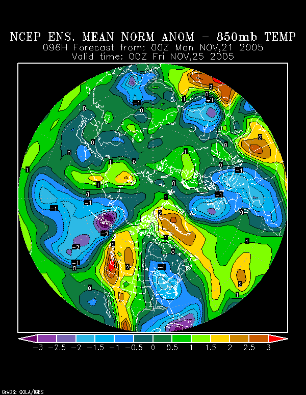
3) The NCEP ensemble mean 500 mb height anomalies and 850 mb temperature anomalies continue to show the cold returning to the East during the first week in December.
Consequently, at least for now, I'm inclined to expect the cold to back off temporarily, with the anomalies shifting westward to the Plains States per the NCEP ensemble mean anomalies. Later, during the first week in December, it should again move toward the east. At that time, the risk of an Arctic outbreak could be growing.
Could this change?
Possibly. If blocking is less than expected, the MJO's continuing evolution might suggest a return of warmth to the east. However, right now, until there have been multiple runs of the models suggesting that the warmup is something more than temporary until the pattern reloads in reasonably short order, I'm not yet alarmed about the new warmer guidance.
1) In fact, the late November warmup was a likely scenario. On November 17, I noted:
Later, the final days of November might see temporary moderation, but the cold should return during the first week in December. As that week advances, I believe that the risk of an Arctic outbreak could be growing.
2) The ensemble forecast for the NAO is now more negative than it was a day earlier for the first part of December. Moreover, the Arctic Oscillation is progged to be negative by most of the ensemble guidance for that timeframe. Since 1950, when the Arctic Oscillation has been negative, the NAO has also been negative approximately 70% of the time in November-December.
3) The NCEP ensemble mean 500 mb height anomalies and 850 mb temperature anomalies continue to show the cold returning to the East during the first week in December.
Consequently, at least for now, I'm inclined to expect the cold to back off temporarily, with the anomalies shifting westward to the Plains States per the NCEP ensemble mean anomalies. Later, during the first week in December, it should again move toward the east. At that time, the risk of an Arctic outbreak could be growing.
Could this change?
Possibly. If blocking is less than expected, the MJO's continuing evolution might suggest a return of warmth to the east. However, right now, until there have been multiple runs of the models suggesting that the warmup is something more than temporary until the pattern reloads in reasonably short order, I'm not yet alarmed about the new warmer guidance.
0 likes
-
donsutherland1
- S2K Analyst
- Posts: 2718
- Joined: Mon Sep 15, 2003 8:49 pm
- Location: New York
Overnight, the 11/23 0z run of the ECMWF joined the 0z GFS in blowtorching the East. By Tuesday (11/30 0z), the ECMWF brought the 10°C 850 mb isotherm almost to Boston.
I'm still not sure that even Josh Beckett's recent signing with the Red Sox will bring that much heat to Beantown--a peak in the 50s is probably more reasonable. I still believe that the warmup will not turn into a prolonged, fiery (relative to normal) agony that stretches through much of the month with only small intrusions of modest chill.
At this time, the AO and NAO are still progged to be negative (even strongly negative on a few ensemble members) by most of the ensembles through the first week in December.
All said, greater blockiness than what is depicted by either the ECMWF or GFS could temper the magnitude of the warmup--which I believe is coming but won't lock in for more than 5-7 days. Late in the first week in December, the risk of an Arctic outbreak could be growing. Certainly, blockiness appears a little more impressive per the NCEP ensemble mean anomalies.
Finally, if everything else fails, there's still the 372-hour GFS (11/23 6z run) that points to cold overwhelming the East. Someone has to keep hope for a return to wintry weather alive, even if it is the 372-hour and beyond GFS.
0 likes
-
cctxhurricanewatcher
- Category 5
- Posts: 1206
- Joined: Sun Sep 12, 2004 8:53 pm
- Location: Corpus Christi, Texas
Looks like one of the NWS offices in Texas are starting to take notice of a pattern shift
Looks like NWS Lubbock sees something down the road.
AREA FORECAST DISCUSSION
NATIONAL WEATHER SERVICE LUBBOCK TX
447 AM CST WED NOV 23 2005
OLD MAN WINTER MAY MAKE A RETURN TO THE SOUTH PALINS AS A MAJOR
PATTERN CHANGE IS POSSIBLE BEHIND THIS UPPER LEVEL STORM SYSTEM BY
THE MIDDLE OF NEXT WEEK. LONG RANGE DGEX AND GFS HINTING AT THE
FIRST REAL ARCTIC AIRMASS TO PLUNGE SOUTH THROUGH THE NORTHERN AND
CENTRAL PLAINS STATES BY MONDAY OR TUESDAY. LONGWAVE UPPER LEVEL
TROUGH IS FORECAST TO DIG SOUTH REACHING THE SOUTH PLAINS BY THE
MIDDLE OF NEXT WEEK. A MUCH COLDER AIRMASS LOOKS POSSIBLE ACROSS
THE SOUTH PLAINS TOWARD THE LATTER HALF OF NEXT WEEK. HAVE TRENDED
TEMPS DOWN A FEW DEGREES FROM THE PREVIOUS THINKING.
HOWEVER...WILL NOT JUMP IN HOOK LINE AND SINKER GIVEN THE AMOUNT
OF UNCERTAINTY IN A DAY 7 THROUGH 9 OUTLOOK FORECAST.
0 likes
-
Jim Hughes
- Category 3

- Posts: 825
- Joined: Sun Jul 24, 2005 1:52 pm
- Location: Martinsburg West Virginia
donsutherland1 wrote:Overnight, the 11/23 0z run of the ECMWF joined the 0z GFS in blowtorching the East. By Tuesday (11/30 0z), the ECMWF brought the 10°C 850 mb isotherm almost to Boston.
I'm still not sure that even Josh Beckett's recent signing with the Red Sox will bring that much heat to Beantown--a peak in the 50s is probably more reasonable. I still believe that the warmup will not turn into a prolonged, fiery (relative to normal) agony that stretches through much of the month with only small intrusions of modest chill.
At this time, the AO and NAO are still progged to be negative (even strongly negative on a few ensemble members) by most of the ensembles through the first week in December.
All said, greater blockiness than what is depicted by either the ECMWF or GFS could temper the magnitude of the warmup--which I believe is coming but won't lock in for more than 5-7 days. Late in the first week in December, the risk of an Arctic outbreak could be growing. Certainly, blockiness appears a little more impressive per the NCEP ensemble mean anomalies.
Finally, if everything else fails, there's still the 372-hour GFS (11/23 6z run) that points to cold overwhelming the East. Someone has to keep hope for a return to wintry weather alive, even if it is the 372-hour and beyond GFS.
Ah...a warming trend. My faith in the stratosphere is back. Of course I never seriously doubted my faith but I will have to admit I was wondering who was fooling around with the weather patterns....Just kidding of course.
I NEVER look at the models. So I either listen to the OCM's out of Washington DC , TWC , or threads within this forum. So I have been perplexed as to why no warming trend was being forecasted for Sunday or slightly later.
Everything seems to be back to normal now. One other note. The forecast trend accuracy seems to be over stating the cold and it's length, at least recently. Nobody was forecasting average temperatures for the prior 2-3 days and that was pretty much what occurred.
We were hearing 5-10 degrees below normal 4-8 days in advance.That did not pan out. I know it's finally here now though.
Jim
0 likes
-
Portastorm

- Storm2k Moderator

- Posts: 9954
- Age: 63
- Joined: Fri Jul 11, 2003 9:16 am
- Location: Round Rock, TX
- Contact:
cctxhurricanewatcher wrote:Looks like one of the NWS offices in Texas are starting to take notice of a pattern shift
Looks like NWS Lubbock sees something down the road.
AREA FORECAST DISCUSSION
NATIONAL WEATHER SERVICE LUBBOCK TX
447 AM CST WED NOV 23 2005
OLD MAN WINTER MAY MAKE A RETURN TO THE SOUTH PALINS AS A MAJOR
PATTERN CHANGE IS POSSIBLE BEHIND THIS UPPER LEVEL STORM SYSTEM BY
THE MIDDLE OF NEXT WEEK. LONG RANGE DGEX AND GFS HINTING AT THE
FIRST REAL ARCTIC AIRMASS TO PLUNGE SOUTH THROUGH THE NORTHERN AND
CENTRAL PLAINS STATES BY MONDAY OR TUESDAY. LONGWAVE UPPER LEVEL
TROUGH IS FORECAST TO DIG SOUTH REACHING THE SOUTH PLAINS BY THE
MIDDLE OF NEXT WEEK. A MUCH COLDER AIRMASS LOOKS POSSIBLE ACROSS
THE SOUTH PLAINS TOWARD THE LATTER HALF OF NEXT WEEK. HAVE TRENDED
TEMPS DOWN A FEW DEGREES FROM THE PREVIOUS THINKING.
HOWEVER...WILL NOT JUMP IN HOOK LINE AND SINKER GIVEN THE AMOUNT
OF UNCERTAINTY IN A DAY 7 THROUGH 9 OUTLOOK FORECAST.
While the operational GFS runs are showing a turn to somewhat colder weather for the southern Plains, including Texas, the ensembles are indicating perhaps a more dramatic turn to colder weather during the first two weeks of December.
Will be interesting to see what happens. I'm not crazy about all of these analogs I'm hearing about 1989! I too remember the pipe-bursting cold we had here in Texas. I remember waking up to 4 degrees here in Austin just 2 days before Christmas. Bbbrrrrr!
0 likes
-
WhiteShirt

- Tropical Storm

- Posts: 121
- Joined: Fri Sep 10, 2004 10:34 pm
- Location: upper Texas coast
Portastorm wrote:cctxhurricanewatcher wrote:Looks like one of the NWS offices in Texas are starting to take notice of a pattern shift
Looks like NWS Lubbock sees something down the road.
AREA FORECAST DISCUSSION
NATIONAL WEATHER SERVICE LUBBOCK TX
447 AM CST WED NOV 23 2005
OLD MAN WINTER MAY MAKE A RETURN TO THE SOUTH PALINS AS A MAJOR
PATTERN CHANGE IS POSSIBLE BEHIND THIS UPPER LEVEL STORM SYSTEM BY
THE MIDDLE OF NEXT WEEK. LONG RANGE DGEX AND GFS HINTING AT THE
FIRST REAL ARCTIC AIRMASS TO PLUNGE SOUTH THROUGH THE NORTHERN AND
CENTRAL PLAINS STATES BY MONDAY OR TUESDAY. LONGWAVE UPPER LEVEL
TROUGH IS FORECAST TO DIG SOUTH REACHING THE SOUTH PLAINS BY THE
MIDDLE OF NEXT WEEK. A MUCH COLDER AIRMASS LOOKS POSSIBLE ACROSS
THE SOUTH PLAINS TOWARD THE LATTER HALF OF NEXT WEEK. HAVE TRENDED
TEMPS DOWN A FEW DEGREES FROM THE PREVIOUS THINKING.
HOWEVER...WILL NOT JUMP IN HOOK LINE AND SINKER GIVEN THE AMOUNT
OF UNCERTAINTY IN A DAY 7 THROUGH 9 OUTLOOK FORECAST.
While the operational GFS runs are showing a turn to somewhat colder weather for the southern Plains, including Texas, the ensembles are indicating perhaps a more dramatic turn to colder weather during the first two weeks of December.
Will be interesting to see what happens. I'm not crazy about all of these analogs I'm hearing about 1989! I too remember the pipe-bursting cold we had here in Texas. I remember waking up to 4 degrees here in Austin just 2 days before Christmas. Bbbrrrrr!
Does this dramatic turn to colder weather include the Houston area? Just how cold are they talking about?
0 likes
-
cctxhurricanewatcher
- Category 5
- Posts: 1206
- Joined: Sun Sep 12, 2004 8:53 pm
- Location: Corpus Christi, Texas
WhiteShirt wrote:Portastorm wrote:cctxhurricanewatcher wrote:Looks like one of the NWS offices in Texas are starting to take notice of a pattern shift
Looks like NWS Lubbock sees something down the road.
AREA FORECAST DISCUSSION
NATIONAL WEATHER SERVICE LUBBOCK TX
447 AM CST WED NOV 23 2005
OLD MAN WINTER MAY MAKE A RETURN TO THE SOUTH PALINS AS A MAJOR
PATTERN CHANGE IS POSSIBLE BEHIND THIS UPPER LEVEL STORM SYSTEM BY
THE MIDDLE OF NEXT WEEK. LONG RANGE DGEX AND GFS HINTING AT THE
FIRST REAL ARCTIC AIRMASS TO PLUNGE SOUTH THROUGH THE NORTHERN AND
CENTRAL PLAINS STATES BY MONDAY OR TUESDAY. LONGWAVE UPPER LEVEL
TROUGH IS FORECAST TO DIG SOUTH REACHING THE SOUTH PLAINS BY THE
MIDDLE OF NEXT WEEK. A MUCH COLDER AIRMASS LOOKS POSSIBLE ACROSS
THE SOUTH PLAINS TOWARD THE LATTER HALF OF NEXT WEEK. HAVE TRENDED
TEMPS DOWN A FEW DEGREES FROM THE PREVIOUS THINKING.
HOWEVER...WILL NOT JUMP IN HOOK LINE AND SINKER GIVEN THE AMOUNT
OF UNCERTAINTY IN A DAY 7 THROUGH 9 OUTLOOK FORECAST.
While the operational GFS runs are showing a turn to somewhat colder weather for the southern Plains, including Texas, the ensembles are indicating perhaps a more dramatic turn to colder weather during the first two weeks of December.
Will be interesting to see what happens. I'm not crazy about all of these analogs I'm hearing about 1989! I too remember the pipe-bursting cold we had here in Texas. I remember waking up to 4 degrees here in Austin just 2 days before Christmas. Bbbrrrrr!
Does this dramatic turn to colder weather include the Houston area? Just how cold are they talking about?
From what I've seen of our NWS Texas offices and their FD's on cold weather events, usually the West Texas offices (Amarillo or Lubbock) pickup on pattern changes first and the thinking moves southward. However I recall some of the old timer forecasters that worked in the Brownsville NWS office would pick up on trends on Arctic outbreaks and the such a long way out. I remember as a kid listening to my weather radio from Radioshack and those guys and they would be sounding the warning bells sometimes two weeks out and they were usually dead on. Unfortunately most if not all of those guys are probably no longer with the NWS due to retirement or other reasons. They did alot of their long range forecasting based on history and analogs.
Today I would say NWS Houston seems to pick up on the trends faster than any of the other NWS offices in the southern part of the state. However the NWS Corpus office is getting a heck of alot better with their long term forecasting too.
0 likes
Who is online
Users browsing this forum: No registered users and 49 guests