For the third time in four years, another early December snowstorm will blanket parts of the Eastern Seaboard. Despite persistently conflicting signals on the computer guidance and only fleeting consensus from time to time, I believe that all the major cities from Richmond to Boston should pick up a plowable snowfall. However, at this time, I do not believe this storm has the makings of the kind of storm that would make the Kocin-Uccellini list.
Given the vast spread in the guidance, I will base my initial estimates largely on the synoptic situation I expect to be in place and the ensemble means. The fact that early data suggests that the December 4 event worked out well gives me some confidence that the overall synoptic situation is evolving pretty much along the lines of my expectations. All said, this would lead to a compromise between the GFS and NAM with perhaps somewhat greater weight toward the NAM ideas.
At this point in time, my preliminary estimates are:
Babylon: 4"-8"
Baltimore: 4”-8”
Boston: 4”-8”
Hartford: 2”-4”
Hazleton: 2”-4”
Islip: 4”-8”
Lynchburg: 6”-10”
New York City: 3”-7”
Newark: 3”-6”
Philadelphia: 3”-7”
Providence: 4”-8”
Raleigh: 1” or less
Richmond: 3”-6”
Washington, DC: 4”-8”
White Plains: 2”-5”
Estimates for parts of Virginia and Maryland could be understated. Those from Philadelphia to Boston have the greatest uncertainty. For now, I’ll take a compromise approach given the persistence of scenario. Adjustments can be made later, as appropriate.
Memory Lane: The December 1886 Snowstorm:
From Atlanta: The snow which began on Friday [December 3] and ended this morning [December 6] extended to the Florida line, the snow being four inches deep in Decatur and Miller Counties, and three and a half feet in Fannin, Union, and Towns.
From Lynchburg, VA: Snow has fallen almost continuously since Saturday morning [December 4, and now measures 15 inches in depth. This is the heaviest fall since 1873.
From Asheville, NC: Snow has fallen to the depth of 26 inches and is still falling.
Source: The New York Times, December 7, 1886.
Early December Storm/Pattern through Mid-December
Moderator: S2k Moderators
Forum rules
 The posts in this forum are NOT official forecast and should not be used as such. They are just the opinion of the poster and may or may not be backed by sound meteorological data. They are NOT endorsed by any professional institution or STORM2K.

The posts in this forum are NOT official forecast and should not be used as such. They are just the opinion of the poster and may or may not be backed by sound meteorological data. They are NOT endorsed by any professional institution or STORM2K.
-
donsutherland1
- S2K Analyst

- Posts: 2718
- Joined: Mon Sep 15, 2003 8:49 pm
- Location: New York
-
Steve Carpenter
- Tropical Low

- Posts: 16
- Joined: Tue Sep 20, 2005 9:45 am
- Location: Asheville, North Carolina
-
WindRunner

- Category 5

- Posts: 5806
- Age: 35
- Joined: Fri Jul 29, 2005 8:07 pm
- Location: Warrenton, VA, but Albany, NY for school
- Contact:
I'm a little SW of DC, Don. You can see Warrenton labeled on the LWX home page. Do you think that that 4-8 still applies here, or would you expect slightly more out here? And when do you see the snow starting on Monday?
0 likes
-
donsutherland1
- S2K Analyst
- Posts: 2718
- Joined: Mon Sep 15, 2003 8:49 pm
- Location: New York
-
donsutherland1
- S2K Analyst
- Posts: 2718
- Joined: Mon Sep 15, 2003 8:49 pm
- Location: New York
Radar data, fit of the current situation with previous runs of the models tipping toward the GFS solutions, along with trends in the model guidance, particularly the retreat of the NAM, lead me to believe that my initial estimates are overdone. This appears to be a smaller-scale event, even in the Mid-Atlantic. As a result, I will reduce my estimates for many locations:
Babylon: 2"-5"
Baltimore: 2”-5”
Boston: 1”-3”
Hartford: 1" or less
Hazleton: 1” or less
Islip: 2”-5”
Lynchburg: 3”-7”
New York City: 1”-3”
Newark: 1”-3”
Philadelphia: 2”-5”
Providence: 2”-4”
Raleigh: 1” or less
Richmond: 2”-5”
Washington, DC: 3”-6”
White Plains: 1” or less
Still, even with the reduced figures, for many cities, December snowfall will have surpassed the December 2004 figures.
Forecast Verification: December 4, 2005 Event:
From: December 2, 2005 5:30 PM:
Boston: 1"-3"; Actual: 1.9"; Within range
Islip: 1" or less; Actual: 1.8"; Error: 0.8"
New Haven: 1"-3"; Actual: 1.5"; Within range
New York City: 2" or less; Actual: 2.5"; Error: 0.5"
Newark: 2" or less; Actual: 3.6"; Error: 1.6"
Philadelphia: 1" or less; Actual: 1.6"; Error: 0.6"
Pittsburgh: 1"-3"; Actual: 1.8"; Within range
Providence: 1"-3"; Actual: 1.6"; Within range
White Plains: 1"-3"; Actual: 2.0"; Within range
From: December 3, 5:30 PM:
Boston: 2"-4"; Actual: 1.9"; Error: 0.1"
Hartford: 2"-4"; Actual: 2.2"; Within range
Islip: 2" or less; Actual: 1.8"; Within range
New Haven: 2"-4"; Actual: 1.5"; Error: 0.5"
New York City: 1"-3"; Actual: 2.5"; Within range
Newark: 1"-3"; Actual: 3.6"; Error: 0.6"
Philadelphia: 1" or less; Actual: 1.6"; Error: 0.6"
Pittsburgh: 1"-3"; Actual: 1.8"; Within range
Providence: 2"-5"; Actual: 1.6"; Error: 0.4"
White Plains: 2"-4"; Actual: 2.0"; Within range
Note: 1.5" figure for New Haven is from North Haven, as no New Haven figures were available.
0 likes
-
donsutherland1
- S2K Analyst
- Posts: 2718
- Joined: Mon Sep 15, 2003 8:49 pm
- Location: New York
Re: Early December Storm/Pattern through Mid-December
Verifications of the final forecast on the December 5-6 event will be posted later today or tomorrow. It appears that snowfall totals fell within the range for 9/15 (60%) of the final estimates. The initial idea, which was overly aggressive, saw only 5/15 (33%).
All said, my overall performance on this event was quite bad.
December 9-10 Event:
From the most recently concluded snowstorm, the final consensus between the GFS and ECMWF that the storm would take a more suppressed track proved correct. In my view, the global models will probably offer a better handle on the late-week storm than the mesoscale models until one is within at least 24-36 hours.
Is there hope for a widespread coastal storm? The NCEP ensemble mean 500 mb height anomalies suggest that there is:
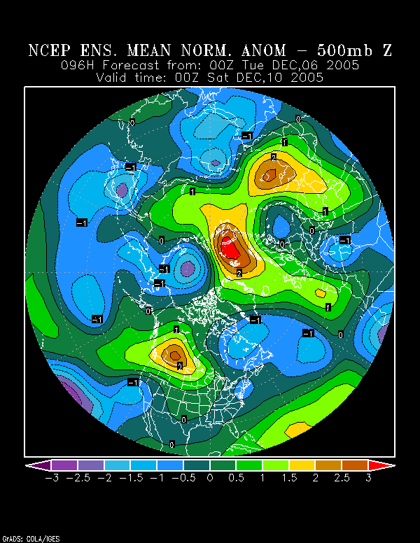
However, the ensemble mean also pointed to a closer track with the December 5-6 event.
In addition, I believe the pattern is evolving somewhat faster than what I had anticipated back on November 30. Then, I noted:
All said, I expect at least the first 10 days of December to continue to see storminess even as the cold increases. Coastal areas could well see measurable precipitation early next week.
The overall pattern should result in measurable snow (and in this case, more than a trace, particularly from PHL to BOS in the December 1-15 timeframe). DCA and RIC could also see measurable snow during this period.
Miller B systems might be the way to go early on, but a more suppressed storm track could develop later in the period, as the cold continues to press into the East. Whether or not a Miller A could occur during this latter period remains to be seen.
For now, it appears that the cold pattern will peak this week and not after the 10th. Indeed, the more suppressed track taken by the recent storm might well have highlighted the somewhat faster evolution.
If that faster idea is correct, then there would also be a greater chance that the pattern would be somewhat less suppressed by week’s end.
For now, erring on the side of caution, I’m placing greater weight on the 12/6 0z ECMWF-12/6 12z GFS ideas, of which the 12z GFS is the more favorable. In terms of the risk of 4” or more snowfall, the following is my current thinking:
Central and northern New England: low
Southern New England: low to moderate
Mid-Atlantic: moderate
Southeast: low
Ohio Valley: low to moderate
Tennessee Valley: low to moderate
Depending on the track, there would be a chance that at least a portion of the coastal plain saw some change to liquid precipitation depending on the storm’s track. Coastal Virginia and the Maryland Eastern Shore likely will see at least a period of liquid precipitation.
Finally, I am not sure that the system will prove to be one for the Kocin-Uccellini list. 4/5 (80%) of the December storms in the book occurred with a positive PDO. The lone exception (December 1969) occurred as the PDO was rising fairly quickly.
All said, my overall performance on this event was quite bad.
December 9-10 Event:
From the most recently concluded snowstorm, the final consensus between the GFS and ECMWF that the storm would take a more suppressed track proved correct. In my view, the global models will probably offer a better handle on the late-week storm than the mesoscale models until one is within at least 24-36 hours.
Is there hope for a widespread coastal storm? The NCEP ensemble mean 500 mb height anomalies suggest that there is:
However, the ensemble mean also pointed to a closer track with the December 5-6 event.
In addition, I believe the pattern is evolving somewhat faster than what I had anticipated back on November 30. Then, I noted:
All said, I expect at least the first 10 days of December to continue to see storminess even as the cold increases. Coastal areas could well see measurable precipitation early next week.
The overall pattern should result in measurable snow (and in this case, more than a trace, particularly from PHL to BOS in the December 1-15 timeframe). DCA and RIC could also see measurable snow during this period.
Miller B systems might be the way to go early on, but a more suppressed storm track could develop later in the period, as the cold continues to press into the East. Whether or not a Miller A could occur during this latter period remains to be seen.
For now, it appears that the cold pattern will peak this week and not after the 10th. Indeed, the more suppressed track taken by the recent storm might well have highlighted the somewhat faster evolution.
If that faster idea is correct, then there would also be a greater chance that the pattern would be somewhat less suppressed by week’s end.
For now, erring on the side of caution, I’m placing greater weight on the 12/6 0z ECMWF-12/6 12z GFS ideas, of which the 12z GFS is the more favorable. In terms of the risk of 4” or more snowfall, the following is my current thinking:
Central and northern New England: low
Southern New England: low to moderate
Mid-Atlantic: moderate
Southeast: low
Ohio Valley: low to moderate
Tennessee Valley: low to moderate
Depending on the track, there would be a chance that at least a portion of the coastal plain saw some change to liquid precipitation depending on the storm’s track. Coastal Virginia and the Maryland Eastern Shore likely will see at least a period of liquid precipitation.
Finally, I am not sure that the system will prove to be one for the Kocin-Uccellini list. 4/5 (80%) of the December storms in the book occurred with a positive PDO. The lone exception (December 1969) occurred as the PDO was rising fairly quickly.
0 likes
-
donsutherland1
- S2K Analyst
- Posts: 2718
- Joined: Mon Sep 15, 2003 8:49 pm
- Location: New York
Re: Early December Storm/Pattern through Mid-December
Per the 12/6 18z GFS and the 12z ECMWF, I am increasingly confident that an appreciable to significant snowfall will impact the Mid-Atlantic and parts of the Northeastern United States.
This evening's NAM is discounted, but only for now. Normally, I'd look for more than some minor initialization issues before rejecting a model run. In this case, it appears that the NAM had more than just minor initialization issues.
00Z NAM RAOB RECAP...
PASY/70414 - LATE FOR NAM.
ABR/72659 - PART AA MISSING FOR NAM. PLEASE RETRANSMIT.
DNR/72469 - 10142...GROUND EQUIPMENT FAILURE.
OUN/72357 - 10142...GROUND EQUIPMENT FAILURE.
FFC/72215 - PURGED WINDS 250 MB AND UP...TOO WEAK.
BMX/72230 - PURGED WINDS 250 MB AND UP...TOO WEAK
I'm most concerned about the issues concerning the upper air data and believe that there is a chance that these issues may have compromised the model's output.
At this time, I am not yet inclined to move away from a compromise between the 18z ECMWF and 12z GFS. The NAM's past performance in its battle for supremacy with the GFS and ECMWF led to its ultimately surrendering to these global models. Given how quickly this event is following on the heels of the last one, I have no strong reasons to believe that the GFS and ECMWF have suddenly lost a handle on the pattern. Later data could change things. But for now, especially with suspect output, I'd rather let the GFS and ECMWF call the shots for now.
So, all in all, one should avoid being spooked by the 12/7 0z run of the NAM. At a minimum, it is not consistent with the ensemble data nor the earlier GFS/ECMWF output. At worst, its output may be compromised to some extent.
In terms of the risk of 4” or more snowfall, the following is my latest thinking:
Central and northern New England: low to moderate
Southern New England: moderate
Mid-Atlantic: moderate
Southeast: low
Ohio Valley: low to moderate
Tennessee Valley: low to moderate
There will likely be an area that receives 6" or more snowfall.
Depending on the track, there would be a chance that at least a portion of the coastal plain saw some change to liquid precipitation depending on the storm’s track. However, especially from the northern New Jersey shore north and eastward, snow will probably be the predominant precipitation even if some warmer air intrudes for a short period of time.
0 likes
-
donsutherland1
- S2K Analyst
- Posts: 2718
- Joined: Mon Sep 15, 2003 8:49 pm
- Location: New York
Re: Early December Storm/Pattern through Mid-December
A quick note...
The 12/7 0z run of the GFS has reaffirmed my thinking. Hence, at this time, I'm not concerned at all by the 12/7 0z NAM. The NAM's solution still appears to be an outlier with little chance at verifying, in my view.
All said, one can sleep comfortably tonight knowing that for now, one can still savor the sweet dream of a Mid-Atlantic/southern New England snowstorm for the not too distant future.
0 likes

Re: Early December Storm/Pattern through Mid-December
donsutherland1 wrote:A quick note...
The 12/7 0z run of the GFS has reaffirmed my thinking. Hence, at this time, I'm not concerned at all by the 12/7 0z NAM. The NAM's solution still appears to be an outlier with little chance at verifying, in my view.
All said, one can sleep comfortably tonight knowing that for now, one can still savor the sweet dream of a Mid-Atlantic/southern New England snowstorm for the not too distant future.
Which does absolutely nothing for us snow starved, snow deprived Atlantans.
Maybe next time, eh?

0 likes
-
donsutherland1
- S2K Analyst
- Posts: 2718
- Joined: Mon Sep 15, 2003 8:49 pm
- Location: New York
Verification:
December 5-6, 2005 Snowstorm
From: December 4, 2005 3:00 PM:
Babylon: 4"-8"; Actual: 5.3"; Within range
Baltimore: 4”-8”; Actual: 2.8"; Error: 1.2"
Boston: 4”-8”; Actual: Trace; Error: 4.0"
Hartford: 2”-4”; Actual: None; Error: 2.0"
Hazleton: 2”-4”; Actual: None; Error: 2.0"
Islip: 4”-8”; Actual: 5.3"; Within range
Lynchburg: 6”-10”; Actual: 3.1"; Error: 2.9"
New York City: 3”-7”; Actual: 1.0"; Error: 2.0"
Newark: 3”-6”; Actual: 1.0"; Error: 2.0"
Philadelphia: 3”-7”; Actual: 4.0"; Within range
Providence: 4”-8”; Actual: 0.7"; Error: 3.3"
Raleigh: 1” or less; Actual: None; Within range
Richmond: 3”-6”; Actual: 4.3"; Within range
Washington, DC: 4”-8”; Actual: 2.9"; Error: 1.1"
White Plains: 2”-5”; Actual: 0.7"; Error: 1.3"
From: December 5, 2005 9:30 am:
Babylon: 2"-5"; Actual: 5.3"; Error: 0.3"
Baltimore: 2”-5”; Actual: 2.8"; Within range
Boston: 1”-3”; Actual: Trace; Error: 1.0"
Hartford: 1" or less; Actual: None; Within range
Hazleton: 1” or less; Actual: None; Within range
Islip: 2”-5”; Actual: 5.3"; Error: 0.3"
Lynchburg: 3”-7”; Actual: 3.1"; Within range
New York City: 1”-3”; Actual: 1.0"; Within range
Newark: 1”-3”; Actual: 1.0"; Within range
Philadelphia: 2”-5”; Actual: 4.0"; Within range
Providence: 2”-4”; Actual: 0.7"; Error: 1.3"
Raleigh: 1” or less; Actual: None; Within range
Richmond: 2”-5”; Actual: 4.3"; Within range
Washington, DC: 3”-6”; Actual: 2.9"; Error: 0.1"
White Plains: 1” or less; Actual: 0.7"; Within range
0 likes
-
donsutherland1
- S2K Analyst
- Posts: 2718
- Joined: Mon Sep 15, 2003 8:49 pm
- Location: New York
Re: Early December Storm/Pattern through Mid-December
JenyEliza,
Hopefully, at some point, we'll see something much farther south so that Atlanta can enjoy some accumulating snow.
Hopefully, at some point, we'll see something much farther south so that Atlanta can enjoy some accumulating snow.
0 likes
-
Dave C
- S2K Supporter

- Posts: 868
- Joined: Thu Sep 04, 2003 4:36 pm
- Location: Middleboro, Mass.(midway between Cape Cod and Boston)
hi
The last system was definately a dissapointment locally. We received 2 inches here with 4.5 on Cape Cod being the highest in New England. Models sure had fun with that one  . Next up... Friday, todays discussion is interesting to say the least!
http://www.erh.noaa.gov/box/products/BOSAFDBOX
I noticed Don that we don't have high pressure to the north, rather to the east of Friday's system. Without proper high placement this could also complicate snow vs rain issue on the coast(water temps in 40s off SNE coast). What's your feel on this factor?
0 likes
Re: Early December Storm/Pattern through Mid-December
donsutherland1 wrote:JenyEliza,
Hopefully, at some point, we'll see something much farther south so that Atlanta can enjoy some accumulating snow.
Would be nice if that happens this winter, but it's really out of our hands isn't it?
Hope everyone who gets snow/winter precip stays safe and warm.
Jen
0 likes
-
donsutherland1
- S2K Analyst
- Posts: 2718
- Joined: Mon Sep 15, 2003 8:49 pm
- Location: New York
-
donsutherland1
- S2K Analyst
- Posts: 2718
- Joined: Mon Sep 15, 2003 8:49 pm
- Location: New York
Re: hi
Dave C,
That setup would be trouble if the storm were strong. I think it will be a late-developer, so the high's placement should be less of a concern, particularly for Boston and areas to its north and west.
There remains a possibility that there could be some rain/mixed precipitation at Nantucket, the Cape, etc. But given the storm's track just to the south and east of the Benchmark (40N 70W, for those who aren't familiar with it), there should be good opportunity for snow.
I believe New England will do much better this time around.
0 likes
-
donsutherland1
- S2K Analyst
- Posts: 2718
- Joined: Mon Sep 15, 2003 8:49 pm
- Location: New York
Re: hi
Morning thoughts:
∙ A moderate to significant snowfall looms for the northern Mid-Atlantic and southern New England regions. Amounts there could reach 4”-8”.
∙ The storm will be a fast-mover and possibly late-developer e.g., not reaching < 1000 mb until it is passing south of Long Island. Unfortunately, such storms often take their heaviest snowfall north and east of Baltimore.
Given the track, the prospect of a brief changeover to rain, particularly north of central New Jersey looks much less likely. For cities such as Newark and New York, the storm will probably bring all frozen precipitation (snow with maybe a brief period of sleet). Coastal areas, especially from Atlantic City southward could see a meaningful period of rain. For the Maryland Eastern Shore i.e. Ocean City, Salisbury, etc., unfortunately, this storm will probably be mainly a rainstorm.
∙ A compromise track between that of the 12/7 0z/6z GFS and 12/6 12z ECMWF/12 7 0z ECMWF looks very good. The 12/7 0z and 6z GFS remain largely consistent with the GFS ensembles and ensemble mean.
Ahead of my preliminary estimates (probably available this afternoon after I’ve seen the 12z guidance), my general thoughts are as follows:
Risk of 4” or more snowfall:
Allentown: Moderate
Babylon: High
Baltimore: Moderate
Boston: Moderate to High
Bridgeport: High
Hartford: Moderate to High
New York City: Moderate to High
Newark: Moderate to High
Philadelphia: Moderate to High
Pittsburgh: Low
Providence: High
Washington, DC: Low to Moderate
White Plains: Moderate to High
Wilmington, DE: Moderate
Worcester: Moderate to High
∙ The idea at the beginning of this thread that the generally colder-than-normal pattern would likely prevail at least to mid-December looks good. Some moderation is possible afterward, but with a building PNA and continued negative NAO, exceptional warmth does not appear likely. Farther ahead, a colder-than-normal Christmas and Hanukkah appear likely.
0 likes
-
JETSTREAM BOB
- Tropical Storm

- Posts: 109
- Joined: Thu Oct 07, 2004 11:25 am
- Location: CHARLOTTE,N.C.
-
donsutherland1
- S2K Analyst
- Posts: 2718
- Joined: Mon Sep 15, 2003 8:49 pm
- Location: New York
-
donsutherland1
- S2K Analyst
- Posts: 2718
- Joined: Mon Sep 15, 2003 8:49 pm
- Location: New York
My preliminary estimates for the December 8-9, 2005 snowstorm:
Allentown: 3”-7”
Babylon: 4”-8”
Baltimore: 4”-8”
Boston: 5”-9”
Bridgeport: 4”-8”
Harrisburg: 3”-6”
Hartford: 4”-8”
New York City: 4”-8”
Newark: 4”-8”
Philadelphia: 4”-8”
Pittsburgh: 2”-5”
Providence: 5”-9”
Washington, DC: 3”-6”
White Plains: 4”-8”
Wilmington: 3”-7”
Key assumptions:
∙ Track is a compromise of 12/7 12z GFS/12/7 0z ECMWF/NCEP ensembles. Some consideration was given to the NAM’s focus of increased precipitation late in the storm’s evolution.
∙ Fast-moving storm
∙ Some mixing along central New Jersey coast southward/eastern Long Island/Nantucket/Cape Cod. Primarily a rainstorm along Maryland’s Eastern Shore.
∙ Estimates, particularly from northern New Jersey north and eastward might need upward revision should precipitation develop explosively. Greatest chance of that happening is probably across central and eastern New England, including the Providence and Boston Metro areas.
∙ Some dry slot concerns for areas south of Philadelphia.
0 likes
-
donsutherland1
- S2K Analyst
- Posts: 2718
- Joined: Mon Sep 15, 2003 8:49 pm
- Location: New York
Who is online
Users browsing this forum: No registered users and 104 guests