SST'S and Anomalies in Atlantic and Pacific

This is the general tropical discussion area. Anyone can take their shot at predicting a storms path.

Moderator: S2k Moderators

Forum rules

The posts in this forum are NOT official forecasts and should not be used as such. They are just the opinion of the poster and may or may not be backed by sound meteorological data. They are NOT endorsed by any professional institution or STORM2K. For official information, please refer to products from the National Hurricane Center and National Weather Service.

Help Support Storm2K
Message
Author
Jim Hughes
Category 3
Category 3
Posts: 825
Joined: Sun Jul 24, 2005 1:52 pm
Location: Martinsburg West Virginia

#261 Postby Jim Hughes » Wed Jan 18, 2006 2:31 pm

x-y-no wrote:
Jim Hughes wrote:P.K.,

I know they are different then Long Paddock but they are basically looking at the same data so I am somewhat surprised by their comments. I guess they are not putting to much emphasis in this recent SOI trend the past week.

The + 21.30 average during the past week is somewhat meaningless but you have to watch out for these developing trends at this time of the year. I would be more inclined to give it more weight if occurred down the road a ways in another 4-8 weeks but it still could be an important indicator.

Especially when you consider the overall absence of positve trends like this the past few years. Lets see what continues. They may be whistling a different tune next update.


Jim


I'm inclined to agree that this is starting to look more significant, Jim.


Well I am cautious about making an assumption off of a small pattern change but OTOH if you were expecting to see a change it can have some significance. Although I must admit I did not expect the positive SOI trend to really kick in until early March.


Jim
0 likes   

MiamiensisWx

#262 Postby MiamiensisWx » Wed Jan 18, 2006 6:35 pm

Jim, does the positive SOI open the door for a La Nina?
0 likes   

Jim Hughes
Category 3
Category 3
Posts: 825
Joined: Sun Jul 24, 2005 1:52 pm
Location: Martinsburg West Virginia

#263 Postby Jim Hughes » Wed Jan 18, 2006 7:58 pm

CapeVerdeWave wrote:Jim, does the positive SOI open the door for a La Nina?


It could not hurt it chances that's for sure. Most moderate to strong ENSO phases are usually accompanied by both SST anomalies and positive or negative SOI phases. They are not always in tune with each other all the time though.

Most people consider the last La Nina to be at it's strongest between 98-99 because this is when the cooler SST anomalies were most consistently well below average. But the cooler conditions did linger on for another 12-18 months later.

The positive SOI trend had weakened considerably during both the summer of 1999 and 2000 but it really strengthened in late 2000. The strongest positive values, for the 30 day & 90 day averages, occurred in December 2000 and not in 1998 or 1999.

So it can be misleading. OTOH many relationships have been found with the SOI averages alone.


Jim
0 likes   

User avatar
cycloneye
Admin
Admin
Posts: 146181
Age: 69
Joined: Thu Oct 10, 2002 10:54 am
Location: San Juan, Puerto Rico

#264 Postby cycloneye » Thu Jan 19, 2006 6:05 pm

Image

I can see some decrease in the temps of the Atlantic anomalys especially considering how warm it was a few weeks ago off the West African coast.Also parts of the central atlantic has cooled somewhat.Let's continue to watch those anomalys in the next few weeks to see a real trend towards cooling or this is only a fluctuation.
0 likes   
Visit the Caribbean-Central America Weather Thread where you can find at first post web cams,radars
and observations from Caribbean basin members Click Here

User avatar
cycloneye
Admin
Admin
Posts: 146181
Age: 69
Joined: Thu Oct 10, 2002 10:54 am
Location: San Juan, Puerto Rico

#265 Postby cycloneye » Mon Jan 23, 2006 2:52 pm

Image

There is some decrease in the anomaly temps in parts of the Atlantic especially off West Africa in the new weekly update where it has been very warm in recent weeks.Still for a second week in a row a warm spot lingers in the central GOM.

Image

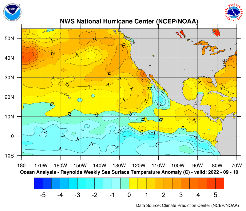
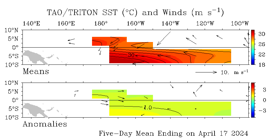
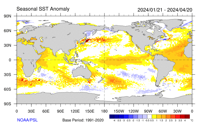
Still basiclly no change in the pacific anomalys with weak la nina conditions prevailing.
0 likes   

User avatar
windycity
S2K Supporter
S2K Supporter
Posts: 461
Joined: Wed Aug 24, 2005 6:45 pm
Location: P.B.county,Fl.
Contact:

#266 Postby windycity » Mon Jan 23, 2006 7:13 pm

maybe its just me, but it looks as though the waters off the fl. east coast are warmer this week than a week ago. ( less dark blue) Was it just that particular sst map,or to be expected for this time of the year or...
0 likes   

User avatar
mike815
Category 5
Category 5
Posts: 1460
Joined: Fri Jul 22, 2005 8:21 am
Location: palm bay fl

#267 Postby mike815 » Mon Jan 23, 2006 10:39 pm

hmmmm... kinda
0 likes   

User avatar
P.K.
Professional-Met
Professional-Met
Posts: 5149
Joined: Thu Sep 23, 2004 5:57 pm
Location: Watford, England
Contact:

#268 Postby P.K. » Tue Jan 24, 2006 7:47 pm

CURRENT STATUS as at 25th January 2006
Next update expected by 8th February 2006 (two weeks after this update).

| Summary | In Brief | Details |

Summary: A cooling Pacific, with some characteristics of a La Niña.


The overall ENSO pattern remains neutral, although with some features of a weak La Niña. This is particularly evident in the cold subsurface waters of the east Pacific, the reduced cloudiness in the central Pacific and the stronger than average Trade Winds in the western Pacific. On the other hand, the SOI remains neutral and sea surface temperatures, though cooler than normal, are not at La Niña levels.

There is a chance that with further cooling, the pattern might develop into a La Niña for a brief period. Historically, the formation of a long-lasting La Niña event at this time of year is extremely rare. Similarly, computer model predictions of ocean temperatures indicate warming after February and ENSO neutral conditions by the middle of 2006.

More information at: http://www.bom.gov.au/climate/enso/
0 likes   

User avatar
cycloneye
Admin
Admin
Posts: 146181
Age: 69
Joined: Thu Oct 10, 2002 10:54 am
Location: San Juan, Puerto Rico

#269 Postby cycloneye » Tue Jan 24, 2006 7:52 pm

P.K. wrote:CURRENT STATUS as at 25th January 2006
Next update expected by 8th February 2006 (two weeks after this update).

| Summary | In Brief | Details |

Summary: A cooling Pacific, with some characteristics of a La Niña.


The overall ENSO pattern remains neutral, although with some features of a weak La Niña. This is particularly evident in the cold subsurface waters of the east Pacific, the reduced cloudiness in the central Pacific and the stronger than average Trade Winds in the western Pacific. On the other hand, the SOI remains neutral and sea surface temperatures, though cooler than normal, are not at La Niña levels.

There is a chance that with further cooling, the pattern might develop into a La Niña for a brief period. Historically, the formation of a long-lasting La Niña event at this time of year is extremely rare. Similarly, computer model predictions of ocean temperatures indicate warming after February and ENSO neutral conditions by the middle of 2006.

More information at: http://www.bom.gov.au/climate/enso/


The Aussies are almost in line with Climate Prediction Centers update two weeks ago maybe a tad more neutral than CPC.
0 likes   
Visit the Caribbean-Central America Weather Thread where you can find at first post web cams,radars
and observations from Caribbean basin members Click Here

User avatar
cycloneye
Admin
Admin
Posts: 146181
Age: 69
Joined: Thu Oct 10, 2002 10:54 am
Location: San Juan, Puerto Rico

#270 Postby cycloneye » Wed Jan 25, 2006 1:23 pm

windycity wrote:maybe its just me, but it looks as though the waters off the fl. east coast are warmer this week than a week ago. ( less dark blue) Was it just that particular sst map,or to be expected for this time of the year or...


Fluctuations occur meaning more warmer waters or more cooler waters in a weeks time.What we have to watch is for long time trends to warmer anomalies or a trend to coler ones and there are 5 months before hurricane season starts to see how the Atlantic sstas will flip.
0 likes   
Visit the Caribbean-Central America Weather Thread where you can find at first post web cams,radars
and observations from Caribbean basin members Click Here

User avatar
cycloneye
Admin
Admin
Posts: 146181
Age: 69
Joined: Thu Oct 10, 2002 10:54 am
Location: San Juan, Puerto Rico

#271 Postby cycloneye » Wed Jan 25, 2006 1:42 pm

Image

Interesting Atlantic loop of ssts.


Sure la nina is now in the Pacific with those kind of anomalies of -1.5c at el nino 3 region.Let's see in the comming weeks how those anomalies will be.

Image
0 likes   

User avatar
cycloneye
Admin
Admin
Posts: 146181
Age: 69
Joined: Thu Oct 10, 2002 10:54 am
Location: San Juan, Puerto Rico

#272 Postby cycloneye » Fri Jan 27, 2006 7:29 pm

Bumping for those who haven't seen the latest sst grapgic for the Atlantic and the ssta's for the Pacific.Still the weak la nina is taking hold.
0 likes   
Visit the Caribbean-Central America Weather Thread where you can find at first post web cams,radars
and observations from Caribbean basin members Click Here

User avatar
cycloneye
Admin
Admin
Posts: 146181
Age: 69
Joined: Thu Oct 10, 2002 10:54 am
Location: San Juan, Puerto Rico

#273 Postby cycloneye » Sat Jan 28, 2006 5:39 pm

Image

The weak La Nina still holds on in the Pacific although a slight warm fluctuation is occuring at el nino 1-2 area.El nino 3-4 areas are cool so that is why La Nina still is there.

In the Atlantic side the MDR area is relativly warm however some pockets of cool anomalys show up in the subtropical Central Atlantic and in the Western Atlantic.

Let's keep watching the anomalys in both basins to see as the 2006 season gets closer how they will be.
0 likes   
Visit the Caribbean-Central America Weather Thread where you can find at first post web cams,radars
and observations from Caribbean basin members Click Here

User avatar
cycloneye
Admin
Admin
Posts: 146181
Age: 69
Joined: Thu Oct 10, 2002 10:54 am
Location: San Juan, Puerto Rico

#274 Postby cycloneye » Mon Jan 30, 2006 1:31 pm

cycloneye wrote:Image

There is some decrease in the anomaly temps in parts of the Atlantic especially off West Africa in the new weekly update where it has been very warm in recent weeks.Still for a third week in a row a warm spot lingers in the central GOM.Also the MDR area has stayed near average to warm anomalys.Let's continue to watch how the anomalys do in the next 3 months and then we will have a much better idea about how warm or not the Atlantic will be when hurricane season 2006 arrives.

Image

Still basiclly no change in the pacific anomalys with weak la nina conditions prevailing although a little warmer anomalys are showing up at el nino 1-2 area.
0 likes   
Visit the Caribbean-Central America Weather Thread where you can find at first post web cams,radars
and observations from Caribbean basin members Click Here

User avatar
wxman57
Moderator-Pro Met
Moderator-Pro Met
Posts: 23019
Age: 67
Joined: Sat Jun 21, 2003 8:06 pm
Location: Houston, TX (southwest)

#275 Postby wxman57 » Mon Jan 30, 2006 2:41 pm

I made an animation of the SST anomolies from Oct 2004 to present. I slowed down the animation as we get into the fall of 2005 and even more so closer to present. Note the dramatic cooling in the Pacific in recent months. Images are 1 week apart:

http://myweb.cableone.net/nolasue/sstanim.gif

Oh, it's a 14MB file so it's not going to load very quickly on dial-up (if anyone still uses dial-up these days). I did make a shorter version that just goes back a few months here:

http://myweb.cableone.net/nolasue/sstanim2.gif

Just looking at the past 3-5 weeks, SST anomolies in the tropical Atlantic are way down, closer to normal.
0 likes   

DrStorm

#276 Postby DrStorm » Mon Jan 30, 2006 4:00 pm

Found this interesting statistic on Nino and Nina, maybe common knowledge...

Bove et al. (1998) analyzed all continental U.S. landfalling hurricanes and intense hurricanes of this century by the concurrent phase of ENSO.

They found that the probability of at least two hurricanes striking the U.S. is:
28% during El Niño years compared with
48% during neutral years and
66% during La Niña years.

Likewise, the probabilities for at least one intense hurricane striking are
23%, 58% and 63%
for El Niño, neutral and La Niña years, respectively.
0 likes   

User avatar
cycloneye
Admin
Admin
Posts: 146181
Age: 69
Joined: Thu Oct 10, 2002 10:54 am
Location: San Juan, Puerto Rico

#277 Postby cycloneye » Sat Feb 04, 2006 3:39 pm

Image

You can see without difficulty how La Nina is in the Pacific by those blue colors.El nino 3 and 4 areas are covered by La Nina cool anomalys of between +1.0c and +1.5c.
0 likes   

User avatar
Ivanhater
Storm2k Moderator
Storm2k Moderator
Posts: 11162
Age: 38
Joined: Fri Jul 01, 2005 8:25 am
Location: Pensacola

#278 Postby Ivanhater » Sat Feb 04, 2006 4:32 pm

Image
0 likes   

User avatar
cycloneye
Admin
Admin
Posts: 146181
Age: 69
Joined: Thu Oct 10, 2002 10:54 am
Location: San Juan, Puerto Rico

#279 Postby cycloneye » Sat Feb 04, 2006 4:47 pm

Image

This is the latest updated graphic of the anomalys in the Atlantic and Pacific.Look how the MDR area between West Africa and the Lesser Antilles is a little above average in the anomaly temps.Also the GOM looks warm in the anomalys.On the flip side parts of the western and central atlantic are somewhat below average.
0 likes   

MiamiensisWx

#280 Postby MiamiensisWx » Sat Feb 04, 2006 5:37 pm

The La Nina seems to have strengthened as well!
0 likes   


Return to “Talkin' Tropics”

Who is online

Users browsing this forum: SconnieCane and 33 guests