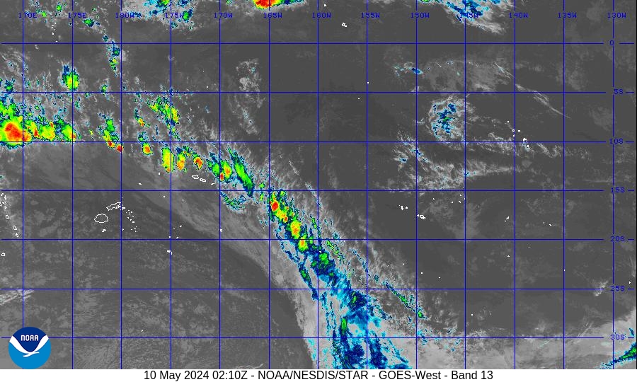
SW Pacific: Tropical Cyclone Vaianu (11P)
Moderator: S2k Moderators
Forum rules

The posts in this forum are NOT official forecasts and should not be used as such. They are just the opinion of the poster and may or may not be backed by sound meteorological data. They are NOT endorsed by any professional institution or STORM2K. For official information, please refer to products from the National Hurricane Center and National Weather Service.


-
HURAKAN

- Professional-Met

- Posts: 46086
- Age: 38
- Joined: Thu May 20, 2004 4:34 pm
- Location: Key West, FL
- Contact:
Tropical Disturbance Advisory Number A7 issued from RSMC NADI
Feb 11/1951 UTC 2006 UTC.
Tropical Cyclone VAIANU [990hPa] centre was located near 17.8 South
175.4 West at 111800 UTC. Position poor and based on MTSAT/EIR with
animation and peripheral surface reports. Repeat position 17.8S
175.4W at 111800 UTC. Cyclone moving southsouthwest at about 07 knots
and expected to curve southwest. Cyclone intensifying. Maximum
10-minute average winds estimated at 40 knots close to the centre
increasing to 45 knots in the next 6 to 12 hours. Expect winds above
33 knots with 60 nautical miles of centre.
TC Vaianu's overall organisation continues to improve despite 10 to
20 knots shear aloft. CIMMS indicates that the cyclone is moving into
a decreasing shear zone and the increased equatorward outflow should
maintain a positive growth curve for the system. LLCC still difficult
to locate and placed near the southern edge of deep convection. The
system lies just south of 250-hPa outflow in a diffluent region. SST
in the area is about 29-30C.
Dvorak analysis based on .60 wrap on log10 spiral gives
DT=MET=PT=3.0, yielding T3.0/3.0/D1.0/24hrs. The system is steered
southwest by a mid-level ridge to east for the next 24 hours and is
expected to curve southeast beyond 48 hours in response to an
approaching broad upper trough from the west. Global models agree on
a southwest track with further intensification in the short term.
FORECAST:
12hrs valid at 120600 UTC near 18.9S 176.3W mov SSW at 07kt with 45
kt close to the centre.
24hrs valid at 121800 UTC near 19.6S 176.9W mov SW at 05kt with 55 kt
close to the centre.
OUTLOOK:
36hrs valid at 130600 UTC near 20.3S 176.7W mov SSE at 05kt with 60kt
close to the centre.
48hrs valid at 131800 UTC near 21.3S 176.3W mov SSE at 06kt with 60kt
close to the centre.
The next Tropical Disturbance Advisory on Tropical Cyclone VAIANU
will be issued around 120200 UTC.
0 likes
-
HURAKAN
- Professional-Met
- Posts: 46086
- Age: 38
- Joined: Thu May 20, 2004 4:34 pm
- Location: Key West, FL
- Contact:

WTPS31 PGTW 112100
NAVOCEANO STENNIS SPACE CENTER MS//N16//
MSGID/GENADMIN/NAVPACMETOCCEN PEARL HARBOR HI/JTWC//
SUBJ/TROPICAL CYCLONE WARNING/111951ZFEB2006//
RMKS/
1. TROPICAL CYCLONE 11P (VAIANU) WARNING NR 002
01 ACTIVE TROPICAL CYCLONE IN SOUTHPAC
MAX SUSTAINED WINDS BASED ON ONE-MINUTE AVERAGE
---
WARNING POSITION:
111800Z --- NEAR 17.6S 175.3W
MOVEMENT PAST SIX HOURS - 230 DEGREES AT 08 KTS
POSITION ACCURATE TO WITHIN 060 NM
POSITION BASED ON CENTER LOCATED BY SATELLITE
PRESENT WIND DISTRIBUTION:
MAX SUSTAINED WINDS - 040 KT, GUSTS 050 KT
RADIUS OF 034 KT WINDS - 070 NM NORTHEAST QUADRANT
080 NM SOUTHEAST QUADRANT
080 NM SOUTHWEST QUADRANT
060 NM NORTHWEST QUADRANT
REPEAT POSIT: 17.6S 175.3W
---
FORECASTS:
12 HRS, VALID AT:
120600Z --- 18.4S 176.3W
MAX SUSTAINED WINDS - 045 KT, GUSTS 055 KT
RADIUS OF 034 KT WINDS - 075 NM NORTHEAST QUADRANT
080 NM SOUTHEAST QUADRANT
080 NM SOUTHWEST QUADRANT
075 NM NORTHWEST QUADRANT
VECTOR TO 24 HR POSIT: 215 DEG/ 05 KTS
---
24 HRS, VALID AT:
121800Z --- 19.2S 176.9W
MAX SUSTAINED WINDS - 050 KT, GUSTS 065 KT
RADIUS OF 034 KT WINDS - 075 NM NORTHEAST QUADRANT
085 NM SOUTHEAST QUADRANT
085 NM SOUTHWEST QUADRANT
075 NM NORTHWEST QUADRANT
VECTOR TO 36 HR POSIT: 185 DEG/ 05 KTS
---
36 HRS, VALID AT:
130600Z --- 20.2S 177.0W
MAX SUSTAINED WINDS - 055 KT, GUSTS 070 KT
RADIUS OF 050 KT WINDS - 020 NM NORTHEAST QUADRANT
020 NM SOUTHEAST QUADRANT
020 NM SOUTHWEST QUADRANT
020 NM NORTHWEST QUADRANT
RADIUS OF 034 KT WINDS - 075 NM NORTHEAST QUADRANT
080 NM SOUTHEAST QUADRANT
080 NM SOUTHWEST QUADRANT
075 NM NORTHWEST QUADRANT
VECTOR TO 48 HR POSIT: 160 DEG/ 06 KTS
---
EXTENDED OUTLOOK:
48 HRS, VALID AT:
131800Z --- 21.3S 176.6W
MAX SUSTAINED WINDS - 055 KT, GUSTS 070 KT
RADIUS OF 050 KT WINDS - 020 NM NORTHEAST QUADRANT
020 NM SOUTHEAST QUADRANT
020 NM SOUTHWEST QUADRANT
020 NM NORTHWEST QUADRANT
RADIUS OF 034 KT WINDS - 065 NM NORTHEAST QUADRANT
070 NM SOUTHEAST QUADRANT
070 NM SOUTHWEST QUADRANT
065 NM NORTHWEST QUADRANT
---
REMARKS:
112100Z POSITION NEAR 17.8S 175.6W.
TROPICAL CYCLONE (TC) 11P (VAIANU), LOCATED APPROXIMATELY 365 NM EAST
OF SUVA, FIJI, HAS TRACKED SOUTHWESTWARD AT 08 KNOTS OVER THE PAST SIX
HOURS. MAXIMUM SIGNIFICANT WAVE HEIGHT AT 111800Z IS 11 FEET. NEXT
WARNINGS AT 120900Z AND 122100Z.

0 likes
-
P.K.

- Professional-Met
- Posts: 5149
- Joined: Thu Sep 23, 2004 5:57 pm
- Location: Watford, England
- Contact:
FXXT01 EGRR 111833
MET OFFICE TROPICAL CYCLONE GUIDANCE FOR SOUTH PACIFIC AND
SOUTH-EAST INDIAN OCEANS
GLOBAL MODEL DATA TIME 12UTC 11.02.2006
TROPICAL CYCLONE VAIANU ANALYSED POSITION : 18.5S 174.1W
VERIFYING TIME POSITION STRENGTH TENDENCY
-------------- -------- -------- --------
12UTC 11.02.2006 18.5S 174.1W MODERATE
00UTC 12.02.2006 19.4S 174.7W MODERATE INTENSIFYING SLIGHTLY
12UTC 12.02.2006 20.5S 175.8W MODERATE LITTLE CHANGE
00UTC 13.02.2006 20.5S 176.3W MODERATE LITTLE CHANGE
12UTC 13.02.2006 22.4S 174.8W MODERATE INTENSIFYING SLIGHTLY
00UTC 14.02.2006 24.6S 174.6W STRONG INTENSIFYING RAPIDLY
12UTC 14.02.2006 25.6S 173.5W STRONG INTENSIFYING SLIGHTLY
00UTC 15.02.2006 27.3S 172.4W STRONG LITTLE CHANGE
12UTC 15.02.2006 29.5S 170.6W STRONG INTENSIFYING SLIGHTLY
00UTC 16.02.2006 32.8S 169.1W INTENSE INTENSIFYING RAPIDLY
12UTC 16.02.2006 33.1S 169.1W STRONG WEAKENING SLIGHTLY
00UTC 17.02.2006 34.4S 168.5W INTENSE INTENSIFYING SLIGHTLY
12UTC 17.02.2006 35.8S 168.0W STRONG WEAKENING RAPIDLY
THIS INFORMATION IS PROVIDED AS GUIDANCE FOR TROPICAL CYCLONE
RSMCS. IT REQUIRES INTERPRETATION BY TROPICAL CYCLONE SPECIALISTS
AND SHOULD NOT BE CONSIDERED AS A FINAL PRODUCT
MET OFFICE, EXETER, UK
0 likes
-
Matt-hurricanewatcher
-
HURAKAN
- Professional-Met
- Posts: 46086
- Age: 38
- Joined: Thu May 20, 2004 4:34 pm
- Location: Key West, FL
- Contact:
Storm Warning 015 issued from RSMC NADI Feb 12/0059 UTC 2006 UTC.
Tropical Cyclone VAIANU [985hPa] centre was located near 18.1 South
175.9 West at 120000 UTC.
Position poor.
Repeat position 18.1S 175.9W at 120000 UTC.
Cyclone moving southwest at about 07 knots.
Cyclone intensifying.
Expect sustained winds of 50 knots close to the centre increasing to
55 knots in the next 6 hours.
Expect winds over 47 knots within 20 miles of centre
and winds over 33 knots within 90 miles of centre.
Forecast position near 19.2S 176.8W at 121200 UTC
and near 19.7S 177.0W at 130000 UTC.
All vessels within 300 nautical miles of the centre are requested to
send reports every three hours to RSMC NADI. VOS reporting ships use
normal channels. Other vessels fax plus 679 6720190 or email naditcc
at met dot gov dot fj.
This warning cancels and replaces warning 014.
0 likes
-
JamesFromMaine2

- Category 4

- Posts: 989
- Joined: Tue Jul 19, 2005 1:38 am
- Location: Portland Maine USA
- Contact:

-
Matt-hurricanewatcher
-
P.K.
- Professional-Met
- Posts: 5149
- Joined: Thu Sep 23, 2004 5:57 pm
- Location: Watford, England
- Contact:
60kts
Tropical Disturbance Advisory Number A9 issued from RSMC NADI
Feb 12/0818 UTC 2006 UTC.
Tropical Cyclone VAIANU [975hPa] centre was located near 18.3 South
176.4 West at 120600 UTC. Position fair and based on MTSAT/EIR with
animation and peripheral surface reports. Repeat position 18.3S
176.4W at 120600 UTC. Cyclone moving southwest at about 06 knots but
is expected to turn south in the next 24 hours. Cyclone intensifying.
Maximum 10-minute average winds estimated at 60 knots close to the
centre, increasing to 65 knots in the next 6 to 12 hours. Expect
winds over 47 knots within 30 miles of centre and winds over 33 knots
within 100 miles of centre in the eastern semicircle and within 80
miles elsewhere.
System organisation has improved after initial supression due to
diurnal influence around 0300 UTC. Convection wraps closer and
tighter to llcc and Vaianu still struggles to form a banding eye. The
system remains embedded in the 250hPa subtropical ridge in a
diffluent region. Outflow remains good in all quadrants. CIMMS
indicates mininal shear over the cyclone and its forecast track
southwards.
Vaianu is expected to further intensify as it moves southwards
tonight, aided by diurnal changes and low environment shear. SST in
the area is about 29-30C.
Dvorak analysis based on 1.05 wrap on log10 spiral gives DT=PT=4.0
while MET=3.5, yielding T4.0/4.0/D1.5/24hrs. The system is steered
southwest by a mid-level ridge located to the east for the next 12
hours and it is expected to curve southwards beyond 12 hours in
response to an approaching broad upper trough from the west. Global
models agree on an initial southwest track with further
intensification.
FORECAST:
12hrs valid at 121800 UTC near 19.3S 177.0W mov SSW at 05kt with 65
kt close to the centre.
24hrs valid at 130600 UTC near 20.7S 177.2W mov SSW at 05kt with 70
kt close to the centre.
OUTLOOK:
36hrs valid at 131800 UTC near 21.9S 177.3W mov SSW at 05kt with 70kt
close to the centre.
48hrs valid at 140600 UTC near 22.5S 176.8W mov S at 05kt with 70kt
close to the centre.
0 likes
-
P.K.
- Professional-Met
- Posts: 5149
- Joined: Thu Sep 23, 2004 5:57 pm
- Location: Watford, England
- Contact:
Tropical Disturbance Advisory Number A10 issued from RSMC NADI
Feb 12/1347 UTC 2006 UTC.
Tropical Cyclone VAIANU [975hPa] centre was located near 18.7 South
176.5 West at 121200 UTC. Position fair and based on MTSAT/EIR with
animation and peripheral surface reports. Repeat position 18.7S
176.5W at 121200 UTC. Cyclone moving southwest at about 06 knots but
is expected to turn south in the next 12 hours. Cyclone intensifying.
Maximum 10-minute average winds estimated at 60 knots close to the
centre, increasing to 65 knots in the next 6 to 12 hours. Expect
winds over 47 knots within 30 miles of centre and winds over 33 knots
within 100 miles of centre in sectors from north through east to
southwest and within 80 miles elsewhere.
Convection wraps closer and tighter to llcc and Vaianu still
struggles to form a banding eye. The system remains embedded in the
250hPa subtropical ridge in a diffluent region. Outflow remains good
in all quadrants. CIMMS indicates mininal shear over the cyclone and
its forecast track. SST in the area is about 29-30C.
Dvorak analysis based on 1.0 wrap on log10 spiral gives DT=4.0 while
PT=MET=3.5, yielding T3.5/4.0/D1.5/24hrs. The system is currently
steered southwest by a mid-level ridge initially but is expected to
curve southwards following an broad upper trough from the west.
Global models agree on an initial southwest track with further
intensification.
FORECAST:
12hrs valid at 130000 UTC near 19.7S 177.0W mov SSW at 05kt with 65
kt close to the centre.
24hrs valid at 131200 UTC near 21.2S 177.7W mov SSW at 07kt with 65
kt close to the centre.
OUTLOOK:
36hrs valid at 140000 UTC near 22.0S 176.8W mov S at 05kt with 60kt
close to the centre.
48hrs valid at 141200 UTC near 22.4S 176.2W mov S at 05kt with 60kt
close to the centre.
The next Tropical Disturbance Advisory on Tropical Cyclone VAIANU
will be issued around 122000 UTC.
0 likes
-
P.K.
- Professional-Met
- Posts: 5149
- Joined: Thu Sep 23, 2004 5:57 pm
- Location: Watford, England
- Contact:
Tropical Cyclone VAIANU [975hPa] centre was located near 19.1 South
176.9 West at 121800 UTC. Position fair and based on MTSAT/EIR with
animation and peripheral surface reports. Repeat position 19.1S
176.9W at 121800 UTC. Cyclone moving southwest at about 05 knots but
is expected to turn south in the next 6 to 12 hours. Cyclone
intensifying. Maximum 10-minute average winds estimated at 60 knots
close to the centre, increasing to 65 knots in the next 6 to 12
hours. Expect winds over 47 knots within 30 miles of centre and winds
over 33 knots within 100 miles of centre in sectors from north
through east to southwest and within 80 miles elsewhere.
Overall organisation improved past 24 hours though development steady
past 6 hours. Warm air intrusion evident past 6 hours. Some warming
of convective tops occuring. The system lies under the 250-hPa ridge
in a diffluent region. Outflow good to south and north and restricted
elsewhere. CIMMS indicates mininal shear over the cyclone. SST in the
area is about 29-30C. Dvorak analysis based on LG embedded centre
yielding DT=4.5. PT=MET=4.0, thus T4.0/4.0/D1.0/24hrs. Cyclone is
being steered by a deep north to northeast steering flow. A gradual
southward turn is expected in the next 6 to 12 hours. Global models
generally agree on this with further intensification.
FORECAST:
12hrs valid at 130600 UTC near 20.3S 177.1W mov S at 06kt with 65 kt
close to the centre.
24hrs valid at 131800 UTC near 21.4S 177.1W mov S at 06kt with 65 kt
close to the centre.
OUTLOOK:
36hrs valid at 140600 UTC near 22.4S 177.3W mov S at 06kt with 60kt
close to the centre.
48hrs valid at 141800 UTC near 23.5S 176.9W mov S at 05kt with 60kt
close to the centre.
The next Tropical Disturbance Advisory on Tropical Cyclone VAIANU
will be issued around 130200 UTC.
0 likes
-
P.K.
- Professional-Met
- Posts: 5149
- Joined: Thu Sep 23, 2004 5:57 pm
- Location: Watford, England
- Contact:
65kts
Tropical Disturbance Advisory Number A13 issued from RSMC NADI
Feb 13/0816 UTC 2006 UTC.
Tropical Cyclone VAIANU [970hPa] centre was located near 20.6 South
176.8 West at 130600 UTC. Position fair. Repeat position 20.6S 176.8W
at 130600 UTC.
Cyclone moving south at about 05 knots and expected to eventually
turn southeast in the next 24 hours. Cyclone intensifying. Expect
sustained winds of 65 knots close to the centre increasing to 70
knots in the next 6 to 12 hours. Expect winds over 63 knots within 20
miles of centre. Expect winds over 47 knots within 40 miles of centre
and over 33 knots within 120 miles of centre in sectors from north
through east to southwest and within 80 miles
elsewhere.
System intensifying with overall organisation improving. LLCC has now
moved under dense cloud cover. Vaianu lies under the 250-hPa ridge in
a diffluent region. Outflow restricted to the northwest but good
elsewhere. Shear remains minimal. SST in the area is about 28-29.
Further intensification anticipated and supported by shortwave trough
and diurnal influence. Dvorak analysis based embedded centre of LG
surr by Black yielding DT=5.0. PT=MET=4.5, FT based on PT thus
T4.5/4.5/D1.0/24hrs. Cyclone is being steered southward by a deep
northerly steering flow. An eventual southeast turn is expected in
the next 24 hours. Global models generally agree on this with further
intensification.
FORECAST:
12hrs valid at 131800 UTC near 21.6S 176.8W mov S at 05kt with 65 kt
close to the centre.
24hrs valid at 140600 UTC near 22.4S 176.5W mov S at 05kt with 70 kt
close to the centre.
OUTLOOK:
36hrs valid at 141800 UTC near 24.2S 176.3W mov SSE at 05kt with 60kt
close to the centre.
48hrs valid at 150600 UTC near 25.3S 175.3W mov SSE at 05kt with 60kt
close to the centre.
The next Tropical Disturbance Advisory on Tropical Cyclone VAIANU
will be issued around 131400 UTC.
0 likes
-
HURAKAN
- Professional-Met
- Posts: 46086
- Age: 38
- Joined: Thu May 20, 2004 4:34 pm
- Location: Key West, FL
- Contact:
WTPS31 PGTW 130900
MSGID/GENADMIN/NAVPACMETOCCEN PEARL HARBOR HI/JTWC//
SUBJ/TROPICAL CYCLONE WARNING//
RMKS/
1. TROPICAL CYCLONE 11P (VAIANU) WARNING NR 005
01 ACTIVE TROPICAL CYCLONE IN SOUTHPAC
MAX SUSTAINED WINDS BASED ON ONE-MINUTE AVERAGE
---
WARNING POSITION:
130600Z --- NEAR 21.0S 176.7W
MOVEMENT PAST SIX HOURS - 175 DEGREES AT 10 KTS
POSITION ACCURATE TO WITHIN 040 NM
POSITION BASED ON CENTER LOCATED BY SATELLITE
PRESENT WIND DISTRIBUTION:
MAX SUSTAINED WINDS - 075 KT, GUSTS 090 KT
RADIUS OF 064 KT WINDS - 025 NM NORTHEAST QUADRANT
025 NM SOUTHEAST QUADRANT
025 NM SOUTHWEST QUADRANT
025 NM NORTHWEST QUADRANT
RADIUS OF 050 KT WINDS - 040 NM NORTHEAST QUADRANT
040 NM SOUTHEAST QUADRANT
040 NM SOUTHWEST QUADRANT
040 NM NORTHWEST QUADRANT
RADIUS OF 034 KT WINDS - 100 NM NORTHEAST QUADRANT
100 NM SOUTHEAST QUADRANT
110 NM SOUTHWEST QUADRANT
100 NM NORTHWEST QUADRANT
REPEAT POSIT: 21.0S 176.7W
---
FORECASTS:
12 HRS, VALID AT:
131800Z --- 22.4S 176.6W
MAX SUSTAINED WINDS - 075 KT, GUSTS 090 KT
RADIUS OF 064 KT WINDS - 025 NM NORTHEAST QUADRANT
025 NM SOUTHEAST QUADRANT
025 NM SOUTHWEST QUADRANT
025 NM NORTHWEST QUADRANT
RADIUS OF 050 KT WINDS - 040 NM NORTHEAST QUADRANT
040 NM SOUTHEAST QUADRANT
040 NM SOUTHWEST QUADRANT
040 NM NORTHWEST QUADRANT
RADIUS OF 034 KT WINDS - 100 NM NORTHEAST QUADRANT
100 NM SOUTHEAST QUADRANT
110 NM SOUTHWEST QUADRANT
100 NM NORTHWEST QUADRANT
VECTOR TO 24 HR POSIT: 160 DEG/ 05 KTS
---
24 HRS, VALID AT:
140600Z --- 23.3S 176.2W
MAX SUSTAINED WINDS - 065 KT, GUSTS 080 KT
RADIUS OF 050 KT WINDS - 035 NM NORTHEAST QUADRANT
035 NM SOUTHEAST QUADRANT
035 NM SOUTHWEST QUADRANT
035 NM NORTHWEST QUADRANT
RADIUS OF 034 KT WINDS - 100 NM NORTHEAST QUADRANT
100 NM SOUTHEAST QUADRANT
110 NM SOUTHWEST QUADRANT
100 NM NORTHWEST QUADRANT
VECTOR TO 36 HR POSIT: 155 DEG/ 05 KTS
---
36 HRS, VALID AT:
141800Z --- 24.3S 175.7W
MAX SUSTAINED WINDS - 060 KT, GUSTS 075 KT
RADIUS OF 050 KT WINDS - 030 NM NORTHEAST QUADRANT
030 NM SOUTHEAST QUADRANT
030 NM SOUTHWEST QUADRANT
030 NM NORTHWEST QUADRANT
RADIUS OF 034 KT WINDS - 090 NM NORTHEAST QUADRANT
090 NM SOUTHEAST QUADRANT
090 NM SOUTHWEST QUADRANT
090 NM NORTHWEST QUADRANT
VECTOR TO 48 HR POSIT: 140 DEG/ 07 KTS
---
EXTENDED OUTLOOK:
48 HRS, VALID AT:
150600Z --- 25.4S 174.7W
MAX SUSTAINED WINDS - 055 KT, GUSTS 070 KT
RADIUS OF 050 KT WINDS - 030 NM NORTHEAST QUADRANT
030 NM SOUTHEAST QUADRANT
030 NM SOUTHWEST QUADRANT
030 NM NORTHWEST QUADRANT
RADIUS OF 034 KT WINDS - 085 NM NORTHEAST QUADRANT
085 NM SOUTHEAST QUADRANT
085 NM SOUTHWEST QUADRANT
085 NM NORTHWEST QUADRANT
---
REMARKS:
130900Z POSITION NEAR 21.3S 176.7W.
TROPICAL CYCLONE (TC) 11P (VAIANU), LOCATED APPROXIMATELY 325 NM
EAST-SOUTHEAST OF SUVA, FIJI, HAS TRACKED SOUTHWARD AT 10 KNOTS
OVER THE PAST SIX HOURS. TC 11P WILL TRACK POLEWARD THROUGHOUT THE
FORECAST PERIOD AS A MID-LEVEL RIDGE TO THE EAST REMAINS THE PRIMARY
STEERING MECHANISM. ALTHOUGH THE CYCLONE HAS INTENSIFIED OVER THE
PAST SEVERAL HOURS, RECENT ANIMATED WATER VAPOR IMAGERY REVEALS
A SUPPRESSION OF STORM OUTFLOW IN THE WESTERN QUADRANTS. UPPER LEVEL
ANALYSIS DEPICTS AN IMPINGING TROUGH AND DEVELOPING LOW JUST TO THE
WEST OF TC 11P. THE STORM SHOULD BEGIN TO WEAKEN WITHIN 24 HOURS DUE
TO DETERIORATING UPPER LEVEL OUTFLOW, INCREASING VERTICAL WIND SHEAR,
AND INCREASING ATMOSPHERIC STABILITY. MAXIMUM SIGNIFICANT WAVE HEIGHT
AT 130600Z IS 28 FEET. NEXT WARNINGS AT 132100Z AND 140900Z.
VAIANU CONTINUES TO INTENSIFY ALTHOUGH IT HAS SLOWED DOWN IN THE SPEED IN WHICH IT WAS DOING SO. THE AIRPORT OF TONGA IS REPORTING RAIN SHOWERS AND SUSTAINED WINDS NEAR 33 MPH. FORTUNATELY THE CENTER OF VAIANU WILL PASS FAR ENOUGH FROM THE ISLAND TO NOT CAUSE MUCH HAVOC!
0 likes
-
P.K.
- Professional-Met
- Posts: 5149
- Joined: Thu Sep 23, 2004 5:57 pm
- Location: Watford, England
- Contact:
70kts
Tropical Disturbance Advisory Number A14 issued from RSMC NADI
Feb 13/1345 UTC 2006 UTC.
Tropical Cyclone VAIANU [965hPa] centre was located near 21.7 South
177.0 West at 131200 UTC. Position fair. Repeat position 21.7S 177.0W
at 131200 UTC. Cyclone moving south at about 08 knots and expected to
eventually turn southeast in the next 12 to 24 hours. Cyclone
intensifying.Expect sustained winds of 70 knots close to the centre
increasing to 80 knots in the next 6 to 12 hours. Expect winds over
63 knots within 20 miles of centre. Expect winds over 47 knots within
40 miles of centre and over 33 knots within 120 miles of centre in
sectors from north through east to southwest and
within 80 miles elsewhere.
System intensifying and overall organisation improving. LLCC is
difficult to locate and remains embedded. Centre placed over a warm
spot[CMG] appearing in the latest EIR imagery. Outflow restricted to
the northwest but good elsewhere. Shear remains minimal. SST in the
area is about 28-29. Further intensification anticipated and
supported by shortwave trough and diurnal influence overnight. Dvorak
analysis based embedded centre of CMG surr by W yielding DT=5.0.
PT=MET=4.5, FT based on PT thus T4.5/4.5/D1.0/24hrs. Cyclone is being
steered southward by a deep northerly steering flow. An eventual
southeast turn is expected in the next 24 hours. Global models
generally agree on this with further intensification.
FORECAST:
12hrs valid at 140000 UTC near 23.1S 176.9W mov S at 07kt with 75 kt
close to the centre.
24hrs valid at 141200 UTC near 24.0S 176.7W mov S at 07kt with 70 kt
close to the centre.
OUTLOOK:
36hrs valid at 150000 UTC near 25.0S 176.0W mov SSE at 06kt with 60kt
close to the centre.
48hrs valid at 151200 UTC near 26.0S 174.8W mov SSE at 06kt with 50kt
close to the centre.
The next Tropical Disturbance Advisory on Tropical Cyclone VAIANU
will be issued around 132000 UTC.
0 likes
-
P.K.
- Professional-Met
- Posts: 5149
- Joined: Thu Sep 23, 2004 5:57 pm
- Location: Watford, England
- Contact:
Tropical Disturbance Advisory Number A15 issued from RSMC NADI
Feb 13/2015 UTC 2006 UTC.
Tropical Cyclone VAIANU [965hPa] centre was located near 22.1 South
176.8 West at 131800 UTC. Position fair. Repeat position 22.1S 176.8W
at 131800 UTC. Cyclone moving south at about 08 knots and expected to
eventually turn southeast in the next 12 hours. Cyclone intensifying.
Expect sustained winds of 70 knots close to the centre increasing to
80 knots in the next 6 to 12 hours. Expect winds over 63 knots within
20 miles of centre, over 47 knots within 40 miles of centre and over
33 knots within 120 miles of centre in sectors from north through
east to southwest and within 80 miles elsewhere.
Overall organisation increasing, gradually, past 6 hours. Convective
bands wrapping tighter around llcc. Outflow good to north and south
but restricted elsewhere. Shear remains minimal. SST in the area is
about 28-29. Further intensification anticipated. Dvorak analysis
based on centre embedded in B yielding DT=5.0. PT=MET=4.5, thus
T4.5/4.5/D0.5/24hrs. Cyclone is being steered southward by a deep
northerly steering flow with an eventual southeast turn is expected
in the next 12 hours. Global models generally agree on this with
further intensification.
FORECAST:
12hrs valid at 140600 UTC near 23.2S 176.3W mov SE at 08kt with 80 kt
close to the centre.
24hrs valid at 141800 UTC near 24.1S 175.7W mov SE at 08kt with 80 kt
close to the centre.
OUTLOOK:
36hrs valid at 150600 UTC near 25.1S 174.7W mov SE at 07kt with 70kt
close to the centre.
48hrs valid at 151800 UTC near 26.4S 173.6W mov SE at 07kt with 50kt
close to the centre.
The next Tropical Disturbance Advisory on Tropical Cyclone VAIANU
will be issued around 140200 UTC.
0 likes
Who is online
Users browsing this forum: Kingarabian, South Texas Storms and 60 guests