Rita Downgraded?
Moderator: S2k Moderators
Forum rules

The posts in this forum are NOT official forecasts and should not be used as such. They are just the opinion of the poster and may or may not be backed by sound meteorological data. They are NOT endorsed by any professional institution or STORM2K. For official information, please refer to products from the National Hurricane Center and National Weather Service.
-
bayouwxman
- Tropical Low

- Posts: 47
- Joined: Wed Aug 27, 2003 10:28 pm
Rita Downgraded?
I seem to remember seeing somewhere in the last few days that Rita will be downgraded to a Category 2 at landfall when the post-storm report comes out. Can anyone confirm this or point me to a discussion on this board that mentions this possibility?
0 likes
-
Pearl River

- S2K Supporter

- Posts: 825
- Age: 66
- Joined: Fri Dec 09, 2005 6:07 pm
- Location: SELa
-
Hybridstorm_November2001

- S2K Supporter
- Posts: 2817
- Joined: Sat Aug 21, 2004 2:50 pm
- Location: SW New Brunswick, Canada
- Contact:
Will be interesting if it is, given all the damage it caused in said region. Just reinforces what I've always thought. Size, and thus duration of hurricane conditions, matter just as much as over all intensity. If Rita had been a small storm, like Andrew, it may not have caused nearly the degree of damage that it did at the same category.
0 likes
-
Derek Ortt
I will have the BT file on Wednesday (unless of course the report comes out tomorrow).
However, ALL data suggests a category 2 at landfall as this was another case where the 90% rule just did not apply. I know this because I flew into Rita and the surface winds from all 4 aircraft suggested an 80% reduction was appropriate
However, ALL data suggests a category 2 at landfall as this was another case where the 90% rule just did not apply. I know this because I flew into Rita and the surface winds from all 4 aircraft suggested an 80% reduction was appropriate
0 likes
-
Jim Cantore

I haven't seen all the damage down there since the media didn't cover it as much as Kat. I have heard it was extremely bad though. A high end cat 2 can do a lot of damage.....I wouldn't be surprised either way.
Last edited by ROCK on Tue Feb 14, 2006 8:07 pm, edited 1 time in total.
0 likes
-
Stratosphere747
- Category 5

- Posts: 3772
- Joined: Thu Sep 11, 2003 8:34 pm
- Location: Surfside Beach/Freeport Tx
- Contact:
I think the classification of Katrina and the possible downgrade of Rita can be taken in a positive manner. For years to come the images from these storms *in particular the SS* should be seared into the minds of coastal county residents.
Show the pictures of Cameron and Holley Beach and the question will be "A cat 2 did this?"
If not for Katrina the primary discussion would be about Rita. Ask the residents of SE Louisiana and Eastern Texas…..
And Houston has done a IMO a horrible job in covering either storm after the fact. We can now see what may lie ahead in our future, but refuse to face up to it…..
0 likes
-
hurricanetrack

- HurricaneTrack.com
- Posts: 1781
- Joined: Tue Dec 02, 2003 10:46 pm
- Location: Wilmington, NC
- Contact:
I am going to have to dig deep in to my video and what little digital data I had from Port Arthur. I had some solid gusts over 108 mph at about 10 feet in an open area. I also know that Josh Wurman was nearby with his DOW. I would sure like to know what those babies recorded. I believe I read he lost his ground instruments- ie- the anemometers. The damage to the trees and structures sure seemed like a 100 knot hurricane. Perhaps categories of hurricanes can be like the Fujita scale- take a look at the damage and go from there. Interesting to see what happens, but weak three would be my call since I was on the ground as it happened. And- I was not sqaurely in the RFQ where the stronger winds might have been.
We simply need an extensive network of 10m towers like Uof FL has to deploy around a landfalling hurricane. That would all but solve the problem of wind speeds at landfall. Anyone know of where we can 2.5 million to do it?
We simply need an extensive network of 10m towers like Uof FL has to deploy around a landfalling hurricane. That would all but solve the problem of wind speeds at landfall. Anyone know of where we can 2.5 million to do it?
0 likes
-
Audrey2Katrina

- Category 5
- Posts: 4252
- Age: 76
- Joined: Fri Dec 23, 2005 10:39 pm
- Location: Metaire, La.
Anyone know of where we can 2.5 million to do it?
Succinctly put, Mark... and I agree
A2K
0 likes
Flossy 56 Audrey 57 Hilda 64* Betsy 65* Camille 69* Edith 71 Carmen 74 Bob 79 Danny 85 Elena 85 Juan 85 Florence 88 Andrew 92*, Opal 95, Danny 97, Georges 98*, Isidore 02, Lili 02, Ivan 04, Cindy 05*, Dennis 05, Katrina 05*, Gustav 08*, Isaac 12*, Nate 17, Barry 19, Cristobal 20, Marco, 20, Sally, 20, Zeta 20*, Claudette 21 IDA* 21 Francine *24

-
terstorm1012

- S2K Supporter
- Posts: 1314
- Age: 44
- Joined: Fri Sep 10, 2004 5:36 pm
- Location: Millersburg, PA
hurricanetrack wrote:I am going to have to dig deep in to my video and what little digital data I had from Port Arthur. I had some solid gusts over 108 mph at about 10 feet in an open area. I also know that Josh Wurman was nearby with his DOW. I would sure like to know what those babies recorded. I believe I read he lost his ground instruments- ie- the anemometers. The damage to the trees and structures sure seemed like a 100 knot hurricane. Perhaps categories of hurricanes can be like the Fujita scale- take a look at the damage and go from there. Interesting to see what happens, but weak three would be my call since I was on the ground as it happened. And- I was not sqaurely in the RFQ where the stronger winds might have been.
We simply need an extensive network of 10m towers like Uof FL has to deploy around a landfalling hurricane. That would all but solve the problem of wind speeds at landfall. Anyone know of where we can 2.5 million to do it?
Only 2.5 mil?
Hmmm...I bet this site could start a fundraising drive. Link up with other weather sites and forums...you'd be surprised as to how much money people raise over the internet. And of course there are, even in these budgetcutting times, grants that can help you along as well from fed, state, and local gov'ts.
0 likes
-
TheEuropean

- Professional-Met

- Posts: 1797
- Age: 60
- Joined: Tue Sep 20, 2005 3:17 pm
- Location: Voerde, Germany
- Contact:
Stratosphere747 wrote:Show the pictures of Cameron and Holley Beach and the question will be "A cat 2 did this?"
If not for Katrina the primary discussion would be about Rita. Ask the residents of SE Louisiana and Eastern Texas…..
The coast at Holy Beach after Rita:
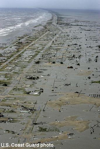
Total devastation from a cat2?
0 likes
-
TheEuropean
- Professional-Met
- Posts: 1797
- Age: 60
- Joined: Tue Sep 20, 2005 3:17 pm
- Location: Voerde, Germany
- Contact:
-
Derek Ortt

hurricanetrack wrote:I am going to have to dig deep in to my video and what little digital data I had from Port Arthur. I had some solid gusts over 108 mph at about 10 feet in an open area. I also know that Josh Wurman was nearby with his DOW. I would sure like to know what those babies recorded. I believe I read he lost his ground instruments- ie- the anemometers. The damage to the trees and structures sure seemed like a 100 knot hurricane. Perhaps categories of hurricanes can be like the Fujita scale- take a look at the damage and go from there. Interesting to see what happens, but weak three would be my call since I was on the ground as it happened. And- I was not sqaurely in the RFQ where the stronger winds might have been.
We simply need an extensive network of 10m towers like Uof FL has to deploy around a landfalling hurricane. That would all but solve the problem of wind speeds at landfall. Anyone know of where we can 2.5 million to do it?
I was stationed at the L'auberge du Lac Casino during the storm and covered the aftermath in SW Louisiana for several days and would have also thought this was a low-end 3. I spent quite a bit of time at the National Weather Service office in Lake Charles and I'm confident they also felt it was a 3. In fact, their anemometer failed, but they felt like they got strong cat. 2 winds and the airport is a good-bit inland.
On the other hand, the limited amount of wind data from the area suggests this may have indeed been a cat. 2.

0 likes
-
wxman57

- Moderator-Pro Met

- Posts: 23133
- Age: 68
- Joined: Sat Jun 21, 2003 8:06 pm
- Location: Houston, TX (southwest)
TheEuropean wrote:Brent wrote:It had a Cat 4/5 surge... just like Katrina, and Katrina wasn't a Cat 4 or 5 at landfall.
You are correct. One lession from the 2005 hurricane season is that surge can be much higher than we normaly expect if the hurricane was much more intense before.
I don't think that the former small area of high winds near Rita's core is nearly as significant in determining storm surge as the tremendous expanse of 75-100 mph winds which continued up to landfall. It's that large area of hurricane-force wind which moved the large volume of water into the coast. The tiny area of Cat 3-4 winds wouldn't move much volume over a large area.
Rita's hurricane force winds covered a much larger area than the typical hurricane, Cat 2 or otherwise. The SS scale does not consider storm surge at all, though there has been some attempt to associate a possible surge range for each category. It may be more appropriate to relate surge height to the areal coverage of higher winds than a small area of peak winds.
Consider these possible storm surge ranges for the current SS scale:
Cat 1 - up to 15 feet
Cat 2 - up to 25 feet
Cat 3 - up to 35 feet
Cat 4-5 up to 40 feet
That kind of scale would be more realistic. Note that having a small area of Cat 3-4-5 winds may not contribute much to the storm surge as a whole. Ivan, Katrina, and Rita had hurricane force and greater winds that were in the top 5% of all hurricanes since 1988 (in terms of square miles). It's unlikely that there would be too many hurricanes with larger wind fields than those three. Gilbert in 1988 would have been one that rivaled them. Hugo was another massive hurricane.
Storm surge depends on a variety of factors:
1. forward speed
2. angle at which the hurricane strikes the coast
3. shape of the sea floor
4. pressure gradient between the core and outer parts of the storm
5. shape of the coast affected
With so many variables, there could be a considerable range in surge values for any particular SS category.
0 likes

hurricanetrack wrote:I am going to have to dig deep in to my video and what little digital data I had from Port Arthur. I had some solid gusts over 108 mph at about 10 feet in an open area. I also know that Josh Wurman was nearby with his DOW. I would sure like to know what those babies recorded. I believe I read he lost his ground instruments- ie- the anemometers. The damage to the trees and structures sure seemed like a 100 knot hurricane. Perhaps categories of hurricanes can be like the Fujita scale- take a look at the damage and go from there. Interesting to see what happens, but weak three would be my call since I was on the ground as it happened. And- I was not sqaurely in the RFQ where the stronger winds might have been.
We simply need an extensive network of 10m towers like Uof FL has to deploy around a landfalling hurricane. That would all but solve the problem of wind speeds at landfall. Anyone know of where we can 2.5 million to do it?
Given that FEMA has literally wasted 300 times more than that so far with Katrina, I'd say the feds should fund it.
0 likes
Also, this goes back to the argument that the NHC needs to have a seperate SURGE WARNING for hurricanes.
A storm coming down from a 5 to a 2/3 will still have the surge of a 4/5 at landfall in the GOM.
A storm coming up to a 2 from a TS or 1 will have the surge of a TS or 1, with small areas of 2 surge.
A storm coming down from a 5 to a 2/3 will still have the surge of a 4/5 at landfall in the GOM.
A storm coming up to a 2 from a TS or 1 will have the surge of a TS or 1, with small areas of 2 surge.
0 likes
Who is online
Users browsing this forum: cycloneye and 54 guests