SST'S and Anomalies in Atlantic and Pacific
Moderator: S2k Moderators
Forum rules
The posts in this forum are NOT official forecasts and should not be used as such. They are just the opinion of the poster and may or may not be backed by sound meteorological data. They are NOT endorsed by any professional institution or STORM2K. For official information, please refer to products from the National Hurricane Center and National Weather Service.
- cycloneye
- Admin

- Posts: 149514
- Age: 69
- Joined: Thu Oct 10, 2002 10:54 am
- Location: San Juan, Puerto Rico

Here is the latest graphic of the atlantic anomalys which show some cooling in portions of the Atlantic but also a little bit more warmer ones.Still there is a warm spot of anomalys in the GOM that has been there for three weeks.
0 likes
Visit the Caribbean-Central America Weather Thread where you can find at first post web cams,radars
and observations from Caribbean basin members Click Here
and observations from Caribbean basin members Click Here
- P.K.
- Professional-Met

- Posts: 5149
- Joined: Thu Sep 23, 2004 5:57 pm
- Location: Watford, England
- Contact:
CURRENT STATUS as at 8th February 2006
Next update expected by 22nd February 2006 (two weeks after this update).
| Summary | In Brief | Details |
Summary: La Niña indicators strengthen
Pacific climate patterns evolved during January and early February to the point where, should the current conditions persist for about another three months, it will be an official La Niña event. Subsurface waters in the eastern equatorial Pacific are particularly cool, but surface temperatures are only bordering on La Niña thresholds. In addition, the Southern Oscillation Index is above +10, the Trade Winds have been enhanced in the central to western Pacific and cloudiness remains substantially suppressed in the central Pacific. All these are consistent with a La Niña.
However, it is unknown in the historical record for a La Niña event of any significance (either in terms of duration or intensity), to evolve at this time of year. Accordingly, we cannot assume the typical Australian
La Niña impacts (widespread above average rainfall, floods, increased tropical cyclone numbers) will occur. Similarly, though the autumn period is generally the maximum time of uncertainty for computer model projections, most computer models predict cool conditions persisting over the next few months followed by warming to ENSO neutral conditions by the middle of 2006.
http://www.bom.gov.au/climate/enso/
0 likes
- cycloneye
- Admin

- Posts: 149514
- Age: 69
- Joined: Thu Oct 10, 2002 10:54 am
- Location: San Juan, Puerto Rico

Interesting loop of the sst's in the Atlantic that you can follow daily to see how the Atlantic is in terms of more warm or less warm waters.
Thanks P.K. for posting the latest from the Aussies which is close to what Noaa has said.Now let's see what CPC update that will be out tommorow will say about the progression of La Nina.

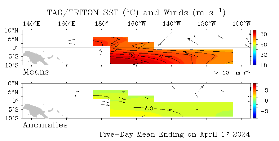
Graphic above of the Pacific and the latest data of anomalys.It shows la nina holding firm by looking at those blue colors and the numbers in centigrade which are around -1.5c to -2.0c at el nino 3-4 area.
0 likes
Visit the Caribbean-Central America Weather Thread where you can find at first post web cams,radars
and observations from Caribbean basin members Click Here
and observations from Caribbean basin members Click Here
-
CHRISTY
- cycloneye
- Admin

- Posts: 149514
- Age: 69
- Joined: Thu Oct 10, 2002 10:54 am
- Location: San Juan, Puerto Rico

Here is the latest graphic update for the Atlantic and it shows not much change from last weeks data.Still the warm spot in the GOM prevails.
0 likes
Visit the Caribbean-Central America Weather Thread where you can find at first post web cams,radars
and observations from Caribbean basin members Click Here
and observations from Caribbean basin members Click Here
-
JonathanBelles
- Professional-Met

- Posts: 11430
- Age: 35
- Joined: Sat Dec 24, 2005 9:00 pm
- Location: School: Florida State University (Tallahassee, FL) Home: St. Petersburg, Florida
- Contact:
- cycloneye
- Admin

- Posts: 149514
- Age: 69
- Joined: Thu Oct 10, 2002 10:54 am
- Location: San Juan, Puerto Rico

The latest data of Pacific anomalys show a slightly weaker la nina than in the past 2 weeks.If you look at el nino area 1-2 close to SouthAmerica you can see some warming of anomalys.However this may be fluctuations that can occur so let's continue to watch the equatorial Pacific to see if the weak La Nina prevails or neutral conditions will dominate.
0 likes
Visit the Caribbean-Central America Weather Thread where you can find at first post web cams,radars
and observations from Caribbean basin members Click Here
and observations from Caribbean basin members Click Here
Hi folks I have been closely reading the commentaries and thoughts on the recent onset of La Nina and the apparent fluctuations in sea surface temps in the Atlantic and have seen what seems to be a very reveling trend. One may say it's a bit disturbing but caution should be taken as many things could happen between now and the actual heart of the hurricane season. Comparatively to last year there are very high sst's around the immediate vicinity of the islands in the Caribbean from Grenada all the way up the chain to the Northern islands.It also begs to reason that Saint Lucia and the Windwards have been experiencing some unseasonal rainfall over the past two months.
Of note is also the fact that the SST's over the Atlantic closer to the COA are not as warm as they were last year around the same time last year.This could be a tentative set up for long trackers accross the Atlantic in conjunction with a favorable Bermuda High. The cooler the sst's remain closer to the coast the longer the systems may tend to remain in a westward motion before responding via a wnw or nw motion.
To summarize it all, the Caribbean and all areas prone to direct storm hits should bare extra vigilant this year much more than ever given what has been occurring climatically over the world.
0 likes
- cycloneye
- Admin

- Posts: 149514
- Age: 69
- Joined: Thu Oct 10, 2002 10:54 am
- Location: San Juan, Puerto Rico
Anthonyl wrote:Hi folks I have been closely reading the commentaries and thoughts on the recent onset of La Nina and the apparent fluctuations in sea surface temps in the Atlantic and have seen what seems to be a very reveling trend. One may say it's a bit disturbing but caution should be taken as many things could happen between now and the actual heart of the hurricane season. Comparatively to last year there are very high sst's around the immediate vicinity of the islands in the Caribbean from Grenada all the way up the chain to the Northern islands.It also begs to reason that Saint Lucia and the Windwards have been experiencing some unseasonal rainfall over the past two months.
Of note is also the fact that the SST's over the Atlantic closer to the COA are not as warm as they were last year around the same time last year.This could be a tentative set up for long trackers accross the Atlantic in conjunction with a favorable Bermuda High. The cooler the sst's remain closer to the coast the longer the systems may tend to remain in a westward motion before responding via a wnw or nw motion.
To summarize it all, the Caribbean and all areas prone to direct storm hits should bare extra vigilant this year much more than ever given what has been occurring climatically over the world.
I agree 100% with your statement about what you said about a more threat to the Caribbean islands this 2006 season.I add that especially the NE Caribbean islands population must be very alert as the tranquil past few years without a hurricane moving thru these islands from Puerto Rico to Guadeloupe may come to an end.But I hope that those systems that form east of us go fishing away from any land.The best thing to do is to prepare for the worse and hope for the best for us who live in the NE Caribbean area.
0 likes
Visit the Caribbean-Central America Weather Thread where you can find at first post web cams,radars
and observations from Caribbean basin members Click Here
and observations from Caribbean basin members Click Here
-
MiamiensisWx
- cycloneye
- Admin

- Posts: 149514
- Age: 69
- Joined: Thu Oct 10, 2002 10:54 am
- Location: San Juan, Puerto Rico
cycloneye wrote:
The latest data of Pacific anomalys show a slightly weaker la nina than in the past 2 weeks.If you look at el nino area 1-2 close to SouthAmerica you can see some warming of anomalys.However this may be fluctuations that can occur so let's continue to watch the equatorial Pacific to see if the weak La Nina prevails or neutral conditions will dominate.

0 likes
Visit the Caribbean-Central America Weather Thread where you can find at first post web cams,radars
and observations from Caribbean basin members Click Here
and observations from Caribbean basin members Click Here
-
MiamiensisWx
- cycloneye
- Admin

- Posts: 149514
- Age: 69
- Joined: Thu Oct 10, 2002 10:54 am
- Location: San Juan, Puerto Rico
wxmann_91 wrote:Good news is CPAC anomalies have died down as well... sign of a fish or EC year? Or will they build back up?
It's too early to tell.I say wait until May and June to see how the anomalies look in those months and by then we can have a much better idea if we will have La nina or neutral conditions.
0 likes
Visit the Caribbean-Central America Weather Thread where you can find at first post web cams,radars
and observations from Caribbean basin members Click Here
and observations from Caribbean basin members Click Here
Who is online
Users browsing this forum: AnnularCane, Ulf and 146 guests


