 The posts in this forum are NOT official forecast and should not be used as such. They are just the opinion of the poster and may or may not be backed by sound meteorological data. They are NOT endorsed by any professional institution or


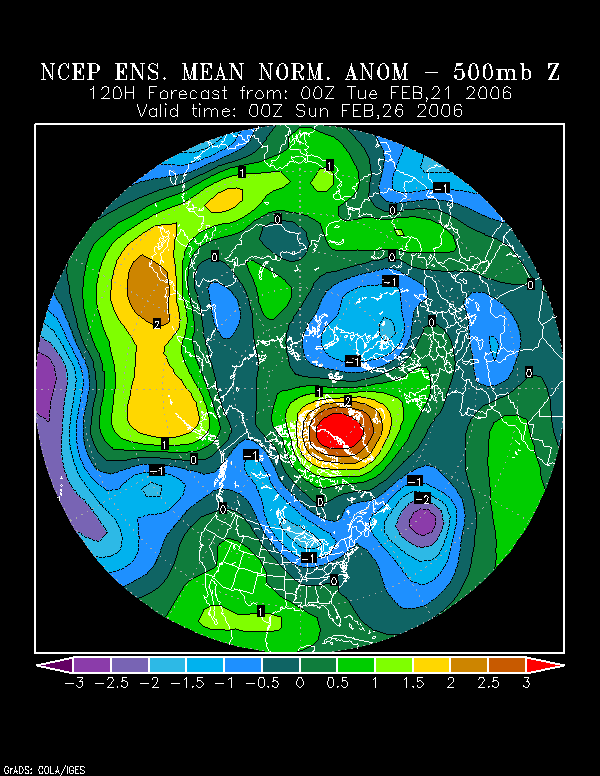
As the developing block heads toward its peak, there is an interesting look to the NCEP ensemble means.
2/21/2006 0z NCEP Ensemble 500 mb Anomalies (standard deviations) at 120 hours:
2/21/2006 0z NCEP Ensemble 500 mb Anomalies (standard deviations) at 144 hours:
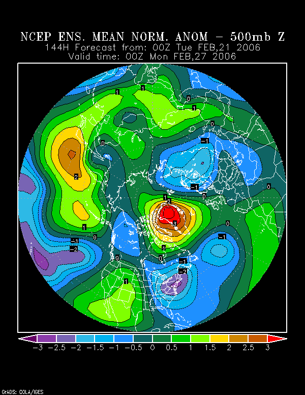
2/21/2006 0z NCEP Ensemble 500 mb Anomalies (standard deviations) at 144 hours:
There, one finds a hint of perhaps an energetic shortwave diving southeastward/east-southeastward from Canada (1.5 standard deviations below normal) strengthening as it does so. As it is centered over the generael southeastern PA/eastern NJ/DE area, it has reached 2.5 standard deviations below normal. Afterward, it moves slowly east-northeastward reaching 3.5 standard deviations below normal.
Is this a hint of a clipper-type or Miller B system that would blow up as it heads off the Mid-Atlantic coast or a suggestion of a wave forming along the Arctic front?
Right now, at least some of the operational guidance is not highly impressed. Most of the GFS ensemble members aren't either. However, there does appear to be at least a measure of support, particularly from NYC north and east.
Forecast Precipitation (mm) from the 2/21 6z GFS (114-144 hours)
Boston: 8.979 mm (0.35")
New York City: 2.569 mm (0.10")
Philadelphia: 1.586 mm (0.06")
Providence: 10.629 mm (0.42")
Morover while precipitation 6-hour precipitation falls of to 0.064 mm at 126 hours, it rises slightly to .262 for the next 6 hours. One also sees a weaker redevelopment of precipitation at Philadelphia (No precipitation for the 6 hours ended at 126 hours and 0.042 mm for the 6 hours ended at 132 hours) over the same timeframe.
Is this a subtle hint of the development of a possible comma-head that is mainly to the north and east of NYC?
Even as there is uncertainty concerning the possibility of storm development that could bring some portions of the East Coast (highest chance in eastern New England and perhaps on Long Island) a possible appreciable snowfall, there is little uncertainty as to the magnitude of cold that appears likely.
Longer-term, I like the idea of a weakening negative NAO, particularly after March 1 (which is backed by the ensembles) and possibly its going > 0 in the 3/5-12 timeframe. However, based on past historical data, I lean toward the redevelopment of a new block not too long after the NAO goes above 0--probably within 10 days or less.
I looked at past blocks that bottomed out in the -1.50 to -2.99 range while forming 2/15-3/5 and found the following:
∙ Median duration: 14 days
∙ Mean duration: 15.4 days
∙ Shortest: 7 days (2/26-3/4/1998)
∙ Longest: 23 days (2/26-3/20/1954)
∙ 5/7 (71%) saw a new blocking episode develop within 10 days or less of the NAO reaching > 0
∙ Both seasons that saw blocks that met the above criteria and similar ENSO conditions saw a return to blocking 10 days or less after the initial block broke.
This repetition of blocking is, among other reasons, why I continue to believe that March could see cooler than normal readings across the Mid-Atlantic, New England, and Ohio Valley regions, not to mention above normal snowfall.
Conclusions:
∙ Readings will likely dive to much below normal levels beginning on Sunday and likely hold there probably through at least Wednesday.
∙ While a small amount of precipitation appears likely from the passage of the Arctic front, there is some possibility (>0) that a storm could develop and impact a portion of the East, particularly the northern Mid-Atlantic and New England regions. For now, the highest risk is probably across eastern Long Island and eastern New England (including Boston and Providence). So, I don't think the possibility of a more important episode of storminess to coincide with the return of Arctic air should be altogether dismissed. Later trends in the modeling and ensembles will likely prove helpful.