SST'S and Anomalies in Atlantic and Pacific
Moderator: S2k Moderators
Forum rules

The posts in this forum are NOT official forecasts and should not be used as such. They are just the opinion of the poster and may or may not be backed by sound meteorological data. They are NOT endorsed by any professional institution or STORM2K. For official information, please refer to products from the National Hurricane Center and National Weather Service.


windycity wrote:the warm water in the gulf has bothered me for months. Its part of the loop current, that i know but its warmer and larger than normal. Perhaps this is the new normal, and its a sign to us to make us think where we should be building.
that loop current is what made Katrina&Rita a storm of legend
0 likes
-
cycloneye

- Admin

- Posts: 149514
- Age: 69
- Joined: Thu Oct 10, 2002 10:54 am
- Location: San Juan, Puerto Rico
cycloneye wrote:
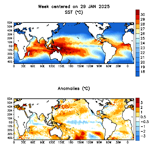
More warming at this update of the data at el nino 1-2 area west of SouthAmerica.Will there be a big surprise of el nino waking up?
Some cool pockets haved appeared in parts of the Atlantic but also there are warm pockets too and the warm anomaly in the GOM persists.


0 likes
Visit the Caribbean-Central America Weather Thread where you can find at first post web cams,radars
and observations from Caribbean basin members Click Here
and observations from Caribbean basin members Click Here
-
cycloneye
- Admin
- Posts: 149514
- Age: 69
- Joined: Thu Oct 10, 2002 10:54 am
- Location: San Juan, Puerto Rico

Here is the graphic of the GOM and the loop current some here are talking about.
0 likes
Visit the Caribbean-Central America Weather Thread where you can find at first post web cams,radars
and observations from Caribbean basin members Click Here
and observations from Caribbean basin members Click Here
-
Jim Hughes
- Category 3

- Posts: 825
- Joined: Sun Jul 24, 2005 1:52 pm
- Location: Martinsburg West Virginia
windycity wrote:i agree. A surprise el nino would be such a blessing, while a neg. enso year would put florida at a higher risk for land falls. Jim, what do you think?
There are many variables to consider here and I could not say at this time as to whether Florida will be at more or less of a risk. Let's see how all of this evolves. We still have a strong AMO and that is the key component here.
Jim
0 likes


-
P.K.

- Professional-Met

- Posts: 5149
- Joined: Thu Sep 23, 2004 5:57 pm
- Location: Watford, England
- Contact:
CURRENT STATUS as at 22nd February 2006
Next update expected by 8th March 2006 (two weeks after this update).
| Summary | In Brief | Details |
Summary: Some easing of La Niña indicators
After a fairly rapid evolution of incipient La Niña conditions by early February, the past two weeks has seen some key indicators ease to levels more typical of neutral conditions. Specifically, central to eastern Pacific surface temperatures have risen abruptly, the SOI has fallen back to near zero and the Trade Winds have decreased to average intensity in the western to central Pacific. However, given the large mass of cooler than average water that remains in the subsurface of the eastern Pacific, it may be premature to assume this trend away from La Niña conditions will continue.
Adding to the uncertainty is the fact that we're nearing the ENSO prediction barrier of March to June, the time when predictability of the climate system is at its lowest, and the time when ENSO events usually decay or begin to form. Neverthelss, Australian and international computer models strongly suggest neutral conditions will be present by the middle of the year due to a steady warming of the central Pacific between now and the southern winter.
It is also unknown in the historical record for a La Niña event of any significance (either in terms of duration or intensity), to evolve during the southern summer. Accordingly, it shouldn't be assumed that typical Australian La Niña impacts (widespread above average rainfall, some flooding, more tropical cyclones) will occur.
0 likes
-
JamesFromMaine2

- Category 4

- Posts: 989
- Joined: Tue Jul 19, 2005 1:38 am
- Location: Portland Maine USA
- Contact:

-
cycloneye
- Admin
- Posts: 149514
- Age: 69
- Joined: Thu Oct 10, 2002 10:54 am
- Location: San Juan, Puerto Rico
If you look at the graphics in this thread and above at this page it seems that less warm conditions once again has got to the area of el Nino 1-2 off SouthAmerica than in the past few days.As I haved said before fluctuations occur many times but what we have to watch for is a definite trend of cool waters persisting or warmer anomalies expanding westward which is not occuring now.
0 likes
Visit the Caribbean-Central America Weather Thread where you can find at first post web cams,radars
and observations from Caribbean basin members Click Here
and observations from Caribbean basin members Click Here
JamesFromMaine2 wrote:The Atlantic is starting to warm up in the past couple of days! Watch the loop and you can really see it!
that bull horn feature in the GOM looks like UT's longhorn mascot
Last edited by f5 on Thu Feb 23, 2006 5:10 pm, edited 1 time in total.
0 likes
-
JonathanBelles
- Professional-Met
- Posts: 11430
- Age: 35
- Joined: Sat Dec 24, 2005 9:00 pm
- Location: School: Florida State University (Tallahassee, FL) Home: St. Petersburg, Florida
- Contact:


Who is online
Users browsing this forum: tolakram and 185 guests