The posts in this forum are NOT official forecast and should not be used as such. They are just the opinion of the poster and may or may not be backed by sound meteorological data. They are NOT endorsed by any professional institution or


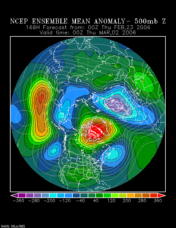
At the same time, the NCEP ensemble 500 mb mean anomalies suggest a trough near or off the East Coast that is 3 or more standard deviations below normal:

Already, the NAO is falling and it will probably go negative either tomorrow or Wednesday:
2/16 +0.901
2/17 +0.702
2/18 +0.490
2/19 +0.215
2/20 +0.150
The implication would be a generally colder-than-normal pattern in the eastern United States. The historical data (1950-2004) for the 2/20-29 period supports such a proposition.
Mean Temperatures for Given NAO Ranges:
Boston:
NAO > 0: 35.6°
NAO -0.99 to 0: 32.1°
NAO -1.99 to -1.00: 33.1°
New York City:
NAO > 0: 39.7°
NAO -0.99 to 0: 35.7°
NAO -1.99 to -1.00: 36.1°
Philadelphia:
NAO > 0: 39.8°
NAO -0.99 to 0: 36.1°
NAO -1.99 to -1.00: 36.9°
Washington, DC (DCA):
NAO > 0: 43.7°
NAO -0.99 to 0: 40.2°
NAO -1.99 to -1.00: 40.8°
Percentage of Days with Highs < 40°:
Boston:
NAO > 0: 18%
NAO -0.99 to 0: 27%
NAO -1.99 to -1.00: 25%
New York City:
NAO > 0: 23%
NAO -0.99 to 0: 35%
NAO -1.99 to -1.00: 41%
Philadelphia:
NAO > 0: 20%
NAO -0.99 to 0: 35%
NAO -1.99 to -1.00: 33%
Washington, DC (DCA):
NAO > 0: 10%
NAO -0.99 to 0: 18%
NAO -1.99 to -1.00: 20%
In addition, there are also some snowfall implications. The Mid-Atlantic region sees a somewhat higher likelihood of accumulating snow.
Percentage of Days that receive 0.1" or More Snowfall:
i]Boston:[/i]
NAO > 0: 17%
NAO -0.99 to 0: 20%
NAO -1.99 to -1.00: 19%
New York City:
NAO > 0: 5%
NAO -0.99 to 0: 10%
NAO -1.99 to -1.00: 13%
Philadelphia:
NAO > 0: 6%
NAO -0.99 to 0: 11%
NAO -1.99 to -1.00: 7%
Washington, DC (DCA):
NAO > 0: 3%
NAO -0.99 to 0: 7%
NAO -1.99 to -1.00: 7%
It should be noted that the magnitude of change that is forecast in the NAO's regime change to negative has sometimes coincided with important storms in the East per Heather Archambault's research.
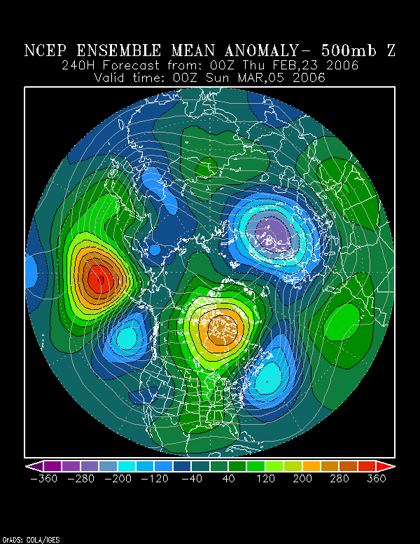
As a result of the developing block, my idea (see my February 16-28 expectations) of moderation to near normal in the 2/23-28 period will probably see an attempted moderation turned back in the closing days of the month. In fact, the NCEP ensemble mean suggests the possibility of a very cold air mass to close out the month and that suggestion appears quite reasonable.
Moreover, with such a deep trough developing to coincide with the growing block, the Mid-Atlantic and New England states will need to be wary of the possibility of at least one or two shots of accumulating snow prior to the end of February. The greatest risk of a moderate to large storm would probably lie in the closing days of the month.
Finally, should such blockiness persist through the first half of March, that would also imply a colder than normal first half of the month. At this time, given the ENSO analogs (ENSO regional anomalies and MEI), past tendencies for weak La Niña/PDO+/QBO East seasons, I believe March will probably prove both cooler than normal and snowier than normal from Washington, DC to Boston. This does not mean that there won't be warm days, as I do believe that the weaker and probably less persistent blocking episode relative to last year's will allow for more warmth.
Interestingly enough, the two analogs per the ENSO regional anomalies and MEI that saw February snowfall of 8" or more in Washington, DC (DCA) and 15" or more at both New York City and Boston were 1966-67 and 1995-96. The small sample size suggests a measure of caution is in order. However, the larger historical patterns (based on seasonal snowfall to date) and La Niña-PDO+ winters suggests a good possibility for above normal snowfall in March.
For now, a block is forming and that should translate into a colder outcome to close February and possibly opportunities for additional snowfall, as well.