SST'S and Anomalies in Atlantic and Pacific
Moderator: S2k Moderators
Forum rules
The posts in this forum are NOT official forecasts and should not be used as such. They are just the opinion of the poster and may or may not be backed by sound meteorological data. They are NOT endorsed by any professional institution or STORM2K. For official information, please refer to products from the National Hurricane Center and National Weather Service.
- cheezyWXguy
- Category 5

- Posts: 6282
- Joined: Mon Feb 13, 2006 12:29 am
- Location: Dallas, TX
-
JonathanBelles
- Professional-Met

- Posts: 11430
- Age: 35
- Joined: Sat Dec 24, 2005 9:00 pm
- Location: School: Florida State University (Tallahassee, FL) Home: St. Petersburg, Florida
- Contact:
- cheezyWXguy
- Category 5

- Posts: 6282
- Joined: Mon Feb 13, 2006 12:29 am
- Location: Dallas, TX
- cycloneye
- Admin

- Posts: 149514
- Age: 69
- Joined: Thu Oct 10, 2002 10:54 am
- Location: San Juan, Puerto Rico


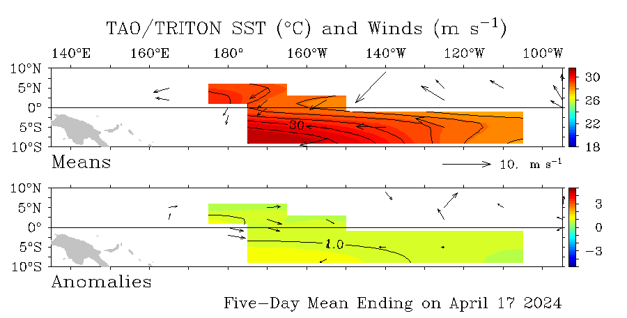
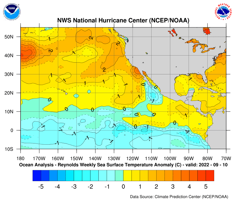
The latest update of the Pacific anomalys show the weak La Nina hanging on despite a small warm pocket that is located close to the SouthAmerican coast.

In the Atlantic side no big changes from last weeks data with scattered pockets of warm and cool anomalys in the Atlantic.Still persists the area of warm anomalies in the GOM.

Above is the graphic of the GOM and the loop current.Also you can see how the Gulfstream waters are.
0 likes
- cycloneye
- Admin

- Posts: 149514
- Age: 69
- Joined: Thu Oct 10, 2002 10:54 am
- Location: San Juan, Puerto Rico
The above graphic at this page which shows the Pacific anomalies indicate a bit more stronger La Nina than in the past 2 weeks if you look at the numbers of between -1.0c to -1.5c.Those yellows indicating warm anomalies are almost gone at el Nino 1-2 area.
0 likes
Visit the Caribbean-Central America Weather Thread where you can find at first post web cams,radars
and observations from Caribbean basin members Click Here
and observations from Caribbean basin members Click Here
-
MiamiensisWx
N.O can't afford another Hurricane like the one in CapeVerdeWave's avatar.worst case scenario means from 1 storm but when its one after the other like Flordia been experienceing it becomes a psychological nightmere .NO officals don't want to have to keep pumping and repumping water out of the city every single time a Katrina or Rita type storm comes roaring through the GOM
0 likes
-
Scorpion
CapeVerdeWave wrote:I still think the La Nina will weaken by summer, resulting in a weak La Nina. The main reason I think so is because of how long the La Nina has been here and how prone to fluctuations it is.
La Nina hasnt been there for awhile. There is nothing out there that will automatically cause the anomolies to go up. If anything it will likely be stronger.
0 likes
-
MiamiensisWx
- cycloneye
- Admin

- Posts: 149514
- Age: 69
- Joined: Thu Oct 10, 2002 10:54 am
- Location: San Juan, Puerto Rico
it is too early to say that it won't weaken.
Yes CapeVerdeWave it's too early to say for sure what will the ENSO conditions be when the hurricane season reaches it's peak although some ENSO models haved predicted a return to Neutral conditions.We have to wait around 2-3 months to see how the anomalies are doing and then we can make our analysis about this factor.
0 likes
Visit the Caribbean-Central America Weather Thread where you can find at first post web cams,radars
and observations from Caribbean basin members Click Here
and observations from Caribbean basin members Click Here
It's kind of interesting looking at the SST anomalies compared to a year ago, even though it really doesn't mean much this far out. Not much difference in the Atlantic but overall a bit cooler this year. Also notice there was a warm spot in the GoM last year too. It was a little weaker and a bit further east.


0 likes
- AussieMark
- Category 5

- Posts: 5857
- Joined: Tue Sep 02, 2003 6:36 pm
- Location: near Sydney, Australia
CapeVerdeWave wrote:I think La Nina has been here since October... it just was not "officially" designated as a La Nina until January. Also, it is too early to say that it won't weaken.
to be La Nina the anomality index has to be at least -0.5C I think
in August it was 0.0C
in September it was 0.0C
in October it was -0.2C
in November it was -0.4C
in December it was -0.7C
so technically December was the start of it
0 likes
- cycloneye
- Admin

- Posts: 149514
- Age: 69
- Joined: Thu Oct 10, 2002 10:54 am
- Location: San Juan, Puerto Rico
Seele wrote:It's kind of interesting looking at the SST anomalies compared to a year ago, even though it really doesn't mean much this far out. Not much difference in the Atlantic but overall a bit cooler this year. Also notice there was a warm spot in the GoM last year too. It was a little weaker and a bit further east.
Yes I agree about the Atlantic Basin especially between Africa and the Lesser Antilles not being as warm as last year by this time.Let's see if this trend holds up as we enter the summer months.
0 likes
Visit the Caribbean-Central America Weather Thread where you can find at first post web cams,radars
and observations from Caribbean basin members Click Here
and observations from Caribbean basin members Click Here
-
MiamiensisWx
- cycloneye
- Admin

- Posts: 149514
- Age: 69
- Joined: Thu Oct 10, 2002 10:54 am
- Location: San Juan, Puerto Rico
CapeVerdeWave wrote:The La Nina has weakened in it's western reaches west of and near 180W. Look how much that area continues to warm up! Notice that?
CapeVerdeWave I think you saw the 2005 graphic above where it shows up that way.The 2006 one is the first one of the 2 graphics posted and shows a different data.
0 likes
Visit the Caribbean-Central America Weather Thread where you can find at first post web cams,radars
and observations from Caribbean basin members Click Here
and observations from Caribbean basin members Click Here
Who is online
Users browsing this forum: No registered users and 142 guests


