The jet would certainly kill it, not that it would get anywhere near that without being torn apart.
What levels is this shear taken between? It doesn't say on the image.
Tropical Depression Basyang at WPAC
Moderator: S2k Moderators
Forum rules

The posts in this forum are NOT official forecasts and should not be used as such. They are just the opinion of the poster and may or may not be backed by sound meteorological data. They are NOT endorsed by any professional institution or STORM2K. For official information, please refer to products from the National Hurricane Center and National Weather Service.

-
cycloneye

- Admin

- Posts: 149506
- Age: 69
- Joined: Thu Oct 10, 2002 10:54 am
- Location: San Juan, Puerto Rico
BULLETIN
TROPICAL DEPRESSION 01W ADVISORY NUMBER 8
800 AM GUAM LST MON MAR 6 2006
...TROPICAL STORM 01W DOWNGRADED TO TROPICAL DEPRESSION...
A TROPICAL STORM WARNING REMAINS IN EFFECT FOR KOROR AND KAYANGEL IN
THE REPUBLIC OF PALAU. THIS MEANS THAT TROPICAL STORM FORCE WINDS OF
39 MPH OR MORE ARE EXPECTED WITHIN 24 HOURS.
A TROPICAL STORM WATCH REMAINS IN EFFECT FOR SONSOROL IN THE
REPUBLIC OF PALAU. THIS MEANS THAT TROPICAL STORM FORCE WINDS OF 39
MPH OR MORE ARE POSSIBLE WITHIN 48 HOURS.
AT 7 AM GUAM LST...2100Z...THE POORLY-DEFINED CENTER OF TROPICAL
DEPRESSION 01W WAS NEAR LATITUDE 6.6 DEGREES NORTH AND LONGITUDE
138.0 DEGREES EAST. THIS IS 250 MILES EAST OF KOROR
250 MILES EAST-SOUTHEAST OF KAYANGEL
120 MILES SOUTH-SOUTHEAST OF NGULU
200 MILES SOUTH OF YAP
410 MILES EAST-NORTHEAST OF SONSOROL
TROPICAL DEPRESSION 01W IS NEARLY STATIONARY...AND IS FORECAST TO
TRACK WESTWARD AT A SLOWLY INCREASING FORWARD SPEED OVER THE NEXT 24
HOURS. THIS FORECAST TRACK WOULD TAKE TROPICAL DEPRESSION 01W SOUTH
OF KOROR LATE TUESDAY MORNING.
MAXIMUM SUSTAINED WINDS ARE 30 MPH. TROPICAL DEPRESSION 01W IS
EXPECTED TO STRENGTHEN AND MAY BECOME A TROPICAL STORM AGAIN LATER
TODAY.
REPEATING THE 7 AM POSITION...6.6 DEGREES NORTH AND 138.0 DEGREES
EAST AND IS NEARLY STATIONARY WITH MAXIMUM SUSTAINED WINDS OF 30
MPH.
FOR STORM INFORMATION SPECIFIC TO YOUR LOCAL AREA...REFER TO
TROPICAL DEPRESSION 01W LOCAL STATEMENT /WTPQ81 PGUM/ AND OTHER
PRODUCTS FROM YOUR LOCAL WEATHER OFFICE.
AN INTERMEDIATE ADVISORY WILL BE ISSUED BY THE NATIONAL WEATHER
SERVICE AT 11 AM GUAM LST FOLLOWED BY THE NEXT SCHEDULED ADVISORY AT
2 PM GUAM LST.
$$
STANKO/MARN
I haven't seen this latest advisory by the Guam NWS posted so here it is.
0 likes
Visit the Caribbean-Central America Weather Thread where you can find at first post web cams,radars
and observations from Caribbean basin members Click Here
and observations from Caribbean basin members Click Here
-
JonathanBelles
- Professional-Met

- Posts: 11430
- Age: 35
- Joined: Sat Dec 24, 2005 9:00 pm
- Location: School: Florida State University (Tallahassee, FL) Home: St. Petersburg, Florida
- Contact:
-
senorpepr

- Military Met/Moderator

- Posts: 12542
- Age: 43
- Joined: Fri Aug 22, 2003 9:22 pm
- Location: Mackenbach, Germany
- Contact:
fact789 wrote:i was talking about the white band to the north of 01w
senorpepr wrote:The blue areas won't.
The green areas will probably affect the storm some.
The yellow areas and higher will kill the storm.
The yellow areas indicate 30 knots of shear. The white areas are >100 knots of shear. If the yellow will kill the storm, you can bet the farm, wife, and kids that the white will kill it.
0 likes
-
senorpepr
- Military Met/Moderator
- Posts: 12542
- Age: 43
- Joined: Fri Aug 22, 2003 9:22 pm
- Location: Mackenbach, Germany
- Contact:
fact789 wrote:Team Ragnarok wrote:I think it's upper-level shear, so 200-500 mb, probably.
i thought mb stood for millibars, if i am wrong explain it to me.
Yes, mb stands for millibars.
200-500mb refers to standard layers of the atmosphere. The 500mb level (or the altitude where the pressure is 500mb) is near 18,000ft. 200mb level (or the altitude where the pressure is 200mb) is near 39,000ft.
0 likes
-
P.K.

- Professional-Met
- Posts: 5149
- Joined: Thu Sep 23, 2004 5:57 pm
- Location: Watford, England
- Contact:
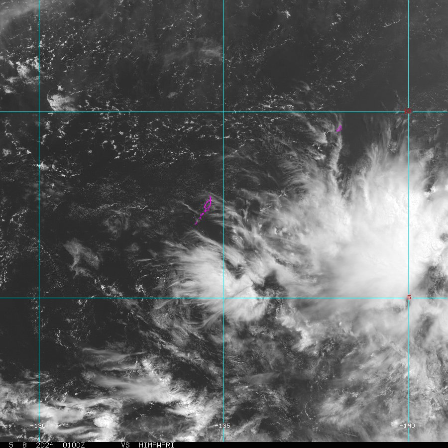
You can definitely see that shear here, got some heights on here for the pressure levels as well.

As you would expect it is very moist in the area of the TD.

Pressure is up to 1008hPa.
Tropical Depression
Issued at 00:00 UTC 6 Mar 2006
RSMC TROPICAL CYCLONE ADVISORY
NAME TD
ANALYSIS
PSTN 060000UTC 04.6N 136.1E POOR
MOVE ALMOST STATIONARY
PRES 1008HPA
MXWD 030KT
FORECAST
24HF 070000UTC 04.8N 133.8E 150NM 70%
MOVE W SLOWLY
PRES 1002HPA
MXWD 035KT
As you would expect it is very moist in the area of the TD.
Pressure is up to 1008hPa.
Tropical Depression
Issued at 00:00 UTC 6 Mar 2006
RSMC TROPICAL CYCLONE ADVISORY
NAME TD
ANALYSIS
PSTN 060000UTC 04.6N 136.1E POOR
MOVE ALMOST STATIONARY
PRES 1008HPA
MXWD 030KT
FORECAST
24HF 070000UTC 04.8N 133.8E 150NM 70%
MOVE W SLOWLY
PRES 1002HPA
MXWD 035KT
0 likes

-
JonathanBelles
- Professional-Met
- Posts: 11430
- Age: 35
- Joined: Sat Dec 24, 2005 9:00 pm
- Location: School: Florida State University (Tallahassee, FL) Home: St. Petersburg, Florida
- Contact:
-
JonathanBelles
- Professional-Met
- Posts: 11430
- Age: 35
- Joined: Sat Dec 24, 2005 9:00 pm
- Location: School: Florida State University (Tallahassee, FL) Home: St. Petersburg, Florida
- Contact:
-
JonathanBelles
- Professional-Met
- Posts: 11430
- Age: 35
- Joined: Sat Dec 24, 2005 9:00 pm
- Location: School: Florida State University (Tallahassee, FL) Home: St. Petersburg, Florida
- Contact:

-
Matt-hurricanewatcher
-
P.K.
- Professional-Met
- Posts: 5149
- Joined: Thu Sep 23, 2004 5:57 pm
- Location: Watford, England
- Contact:
FXPQ20 RJTD 060000
RSMC GUIDANCE FOR FORECAST
NAME TD
PSTN 060000UTC 04.6N 136.1E
PRES 1008HPA
MXWD 30KT
FORECAST BY TYPHOON MODEL
TIME PSTN PRES MXWD
(CHANGE FROM T=0)
T=06 03.5N 135.0E -003HPA -003KT
T=12 03.7N 133.8E -001HPA -002KT
T=18 03.4N 132.9E -003HPA -003KT
T=24 03.6N 132.2E -002HPA +001KT
T=30 04.3N 131.0E -005HPA +002KT
T=36 04.8N 129.5E -003HPA +004KT
T=42 05.2N 127.8E -004HPA +005KT
T=48 05.6N 126.6E -006HPA +013KT
T=54 07.0N 124.8E -006HPA +001KT
T=60 08.1N 123.0E -004HPA +008KT
T=66 08.3N 121.2E -005HPA +017KT
T=72 08.8N 119.6E -005HPA +018KT
T=78 09.0N 118.2E -007HPA +016KT
T=84 09.1N 117.2E -005HPA +012KT
T=90 ///// ////// /////// //////=
0 likes
Who is online
Users browsing this forum: cycloneye, South Texas Storms and 163 guests